
 Search
Long Range Thread 9.0
Page 16 of 40 •  1 ... 9 ... 15, 16, 17 ... 28 ... 40
 ![]()
Re: Long Range Thread 9.0
![]() by skinsfan1177 Tue Dec 08, 2015 8:25 pm
by skinsfan1177 Tue Dec 08, 2015 8:25 pm
amugs wrote:skinsfan1177 wrote:Does any of this have any effect on a pattern locking in or not more of a transient setup
Don't know yet but at worst I would say transient. Guys in other forums saying a ssw is happening by thebeater part of next week on rhe models and a pretty strong one at that. Tome will tell Skins. Let's hope for the best my man.
Fingers crossed Positive Vibes
skinsfan1177- Senior Enthusiast

- Posts : 4485
Join date : 2013-01-07
Re: Long Range Thread 9.0
![]() by amugs Tue Dec 08, 2015 8:36 pm
by amugs Tue Dec 08, 2015 8:36 pm

amugs- Advanced Forecaster - Mod

- Posts : 15093
Join date : 2013-01-07
Re: Long Range Thread 9.0
![]() by Frank_Wx Tue Dec 08, 2015 10:36 pm
by Frank_Wx Tue Dec 08, 2015 10:36 pm
rb924119 wrote:Uhhhh, Merry Chr-ICE-stmas anyone???? Lmao
Just a bit on the extreme side of things ahaha

Nice, but it's so far out.
algae888 wrote:I could be wrong about this but isn't there a 2 to 3 month lag time for our area with el-nino weakening with regards to seeing any effect in the overall pattern. if correct this weakening of el-nino would not have an impact on our area until mid feb. I thought that the central based el-nino rather than east based and convection around the dateline is whats beneficial for us.
More like 3-6 weeks
amugs wrote:Frank_Wx wrote:Long day at work. I'll look at some models tonight. Seems to be some optimism in this thread tonight....
Franky needs consistency but each run sin e 6z trending better so far so pour yourself a cold one or warm one sit back and roll the model runs.

If that block is real, look out.
amugs wrote:I'll take 5 his from the 18z GEFS in a heartbeat.mobile at mu son hockey game at an outdoor rink woop woop
East based block near Scandinavia. That would help perturb the Strat too
_________________
_______________________________________________________________________________________________________
CLICK HERE to view NJ Strong Snowstorm Classifications

Frank_Wx- Godzilla Seeker

- Posts : 21305
Reputation : 328
Join date : 2013-01-05
Age : 31
Location : Jersey City, NJ -

Re: Long Range Thread 9.0
![]() by Frank_Wx Tue Dec 08, 2015 10:44 pm
by Frank_Wx Tue Dec 08, 2015 10:44 pm
_________________
_______________________________________________________________________________________________________
CLICK HERE to view NJ Strong Snowstorm Classifications
Frank_Wx- Godzilla Seeker
- Posts : 21305
Reputation : 328
Join date : 2013-01-05
Age : 31
Location : Jersey City, NJ -
Re: Long Range Thread 9.0
![]() by amugs Tue Dec 08, 2015 10:57 pm
by amugs Tue Dec 08, 2015 10:57 pm
12z
.png)
18z
.png)
_________________
Mugs
AKA:King: Snow Weenie
Self Proclaimed
WINTER 2014-15 : 55.12" +.02 for 6 coatings (avg. 35")
WINTER 2015-16 Total - 29.8" (Avg 35")
WINTER 2016-17 : 39.5" so far

amugs- Advanced Forecaster - Mod
- Posts : 15093
Reputation : 213
Join date : 2013-01-07
Age : 54
Location : Hillsdale,NJ
Re: Long Range Thread 9.0
![]() by sroc4 Wed Dec 09, 2015 11:36 am
by sroc4 Wed Dec 09, 2015 11:36 am
GFS Op Last nights 00z, 6z, then 12z. Marked differences with timing and strength at 500mb leads to these differences at the surface. All 3 images represent 00z on Dec15th.


_________________
"In weather and in life, there's no winning and losing; there's only winning and learning."
WINTER 2012/2013 TOTALS 43.65"WINTER 2017/2018 TOTALS 62.85" WINTER 2022/2023 TOTALS 4.9"
WINTER 2013/2014 TOTALS 64.85"WINTER 2018/2019 TOTALS 14.25" WINTER 2023/2024 TOTALS 13.1"
WINTER 2014/2015 TOTALS 71.20"WINTER 2019/2020 TOTALS 6.35"
WINTER 2015/2016 TOTALS 35.00"WINTER 2020/2021 TOTALS 37.75"
WINTER 2016/2017 TOTALS 42.25"WINTER 2021/2022 TOTALS 31.65"

sroc4- Admin
- Posts : 8331
Reputation : 301
Join date : 2013-01-07
Location : Wading River, LI
Re: Long Range Thread 9.0
![]() by algae888 Wed Dec 09, 2015 11:49 am
by algae888 Wed Dec 09, 2015 11:49 am

algae888- Advanced Forecaster

- Posts : 5311
Reputation : 46
Join date : 2013-02-05
Age : 61
Location : mt. vernon, new york
Re: Long Range Thread 9.0
![]() by sroc4 Wed Dec 09, 2015 12:23 pm
by sroc4 Wed Dec 09, 2015 12:23 pm
algae888 wrote:Scott after the system passes we get cold for half a day and then Heights rise again and we should be into the fifties from the 17th thru the 19th. eps agrees. Last week's GFS showed cold air at this time frame for us with a possible storm the one on mug's birthday. obviously this is not happening and probably not anytime soon after. I think the only thing that's going to break this pattern is an sswe which the models are hinting at. But if this does happen we will not feel its effects until sometime in January. Can we time cold air and a short wave interacting at the same time sure we can but its hard to be confident about that at the moment
As I pointed out Al this is not a pattern changer. That being said models are continuing to flip and flop with this first system. There will be another GLC in its wake that yes it appears we will be in the warm sector again between the 16th-18th until it forces the cold front through. However; after the second system, which also looks fairly postent in MSLP ,notice how there is now a pretty potent HP forming in western and central Canada.
 " />
" />This has not shown up yet at all this season because of the progressive Pacific jet. But as I pointed out in my prev post the LR is hinting at the possibility of some higher heights in the EPO regions and NAO regions. The 12z GFS verbatim has a ridge into Western Canada which directly results in the HP in the above image. Here is the GFS 500mb for the same time as the surface map above.
 " />
" />Obviously in this set up the timing must be perfect. The trough you see in the SW at 500mb will cont to kick out pieces of energy. If there is a strong enough HP to the N it could block it enough so it follows a more southerly track and could make it somehwre in the vacinity of the coast to at least give us a peak.
EPS has been hinting at something coming out of the SW for awhile now.
[img]
 [/img]
There is still a huge spread however on ensembles which is prob due to the same reason the operationals cvont to flip. Exactly what happens with GLC one around the 14th-15th then GLC two around the 16th-18th is still in question so the time frame shortly after is still up in the air. Even if we dont get a snow storm I still think the coldest air so far is coming after that time frame.
Again Al this is all LR stuff so alot can and will prob change, hopefully for the beter, but the chances for snow for someone on or near the coast between the 18th-25th is not zero.
_________________
"In weather and in life, there's no winning and losing; there's only winning and learning."
WINTER 2012/2013 TOTALS 43.65"WINTER 2017/2018 TOTALS 62.85" WINTER 2022/2023 TOTALS 4.9"
WINTER 2013/2014 TOTALS 64.85"WINTER 2018/2019 TOTALS 14.25" WINTER 2023/2024 TOTALS 13.1"
WINTER 2014/2015 TOTALS 71.20"WINTER 2019/2020 TOTALS 6.35"
WINTER 2015/2016 TOTALS 35.00"WINTER 2020/2021 TOTALS 37.75"
WINTER 2016/2017 TOTALS 42.25"WINTER 2021/2022 TOTALS 31.65"
sroc4- Admin
- Posts : 8331
Reputation : 301
Join date : 2013-01-07
Location : Wading River, LI
Re: Long Range Thread 9.0
![]() by amugs Wed Dec 09, 2015 2:00 pm
by amugs Wed Dec 09, 2015 2:00 pm


_________________
Mugs
AKA:King: Snow Weenie
Self Proclaimed
WINTER 2014-15 : 55.12" +.02 for 6 coatings (avg. 35")
WINTER 2015-16 Total - 29.8" (Avg 35")
WINTER 2016-17 : 39.5" so far
amugs- Advanced Forecaster - Mod
- Posts : 15093
Reputation : 213
Join date : 2013-01-07
Age : 54
Location : Hillsdale,NJ
Re: Long Range Thread 9.0
![]() by algae888 Wed Dec 09, 2015 2:07 pm
by algae888 Wed Dec 09, 2015 2:07 pm

algae888- Advanced Forecaster
- Posts : 5311
Reputation : 46
Join date : 2013-02-05
Age : 61
Location : mt. vernon, new york
Re: Long Range Thread 9.0
![]() by NjWeatherGuy Wed Dec 09, 2015 5:40 pm
by NjWeatherGuy Wed Dec 09, 2015 5:40 pm
http://mag.ncep.noaa.gov/Image.php?fhr=384&image=data%2Fgfs%2F12%2Fgfs_namer_384_850_temp_mslp_precip.gif&model=gfs&area=namer¶m=850_temp_mslp_precip&group=Model+Guidance&preselected_formatted_cycle_date=20151209+12+UTC&imageSize=M&ps=model

NjWeatherGuy- Advanced Forecaster
- Posts : 4100
Reputation : 28
Join date : 2013-01-06
Location : Belle Mead, NJ
Re: Long Range Thread 9.0
![]() by amugs Wed Dec 09, 2015 7:17 pm
by amugs Wed Dec 09, 2015 7:17 pm

_________________
Mugs
AKA:King: Snow Weenie
Self Proclaimed
WINTER 2014-15 : 55.12" +.02 for 6 coatings (avg. 35")
WINTER 2015-16 Total - 29.8" (Avg 35")
WINTER 2016-17 : 39.5" so far
amugs- Advanced Forecaster - Mod
- Posts : 15093
Reputation : 213
Join date : 2013-01-07
Age : 54
Location : Hillsdale,NJ
Re: Long Range Thread 9.0
![]() by amugs Wed Dec 09, 2015 7:35 pm
by amugs Wed Dec 09, 2015 7:35 pm

_________________
Mugs
AKA:King: Snow Weenie
Self Proclaimed
WINTER 2014-15 : 55.12" +.02 for 6 coatings (avg. 35")
WINTER 2015-16 Total - 29.8" (Avg 35")
WINTER 2016-17 : 39.5" so far
amugs- Advanced Forecaster - Mod
- Posts : 15093
Reputation : 213
Join date : 2013-01-07
Age : 54
Location : Hillsdale,NJ
Re: Long Range Thread 9.0
![]() by amugs Wed Dec 09, 2015 7:37 pm
by amugs Wed Dec 09, 2015 7:37 pm

THIS


_________________
Mugs
AKA:King: Snow Weenie
Self Proclaimed
WINTER 2014-15 : 55.12" +.02 for 6 coatings (avg. 35")
WINTER 2015-16 Total - 29.8" (Avg 35")
WINTER 2016-17 : 39.5" so far
amugs- Advanced Forecaster - Mod
- Posts : 15093
Reputation : 213
Join date : 2013-01-07
Age : 54
Location : Hillsdale,NJ
Re: Long Range Thread 9.0
![]() by jmanley32 Wed Dec 09, 2015 8:44 pm
by jmanley32 Wed Dec 09, 2015 8:44 pm

jmanley32- Senior Enthusiast
- Posts : 20517
Reputation : 108
Join date : 2013-12-12
Age : 42
Location : Yonkers, NY
Re: Long Range Thread 9.0
![]() by Frank_Wx Wed Dec 09, 2015 10:53 pm
by Frank_Wx Wed Dec 09, 2015 10:53 pm

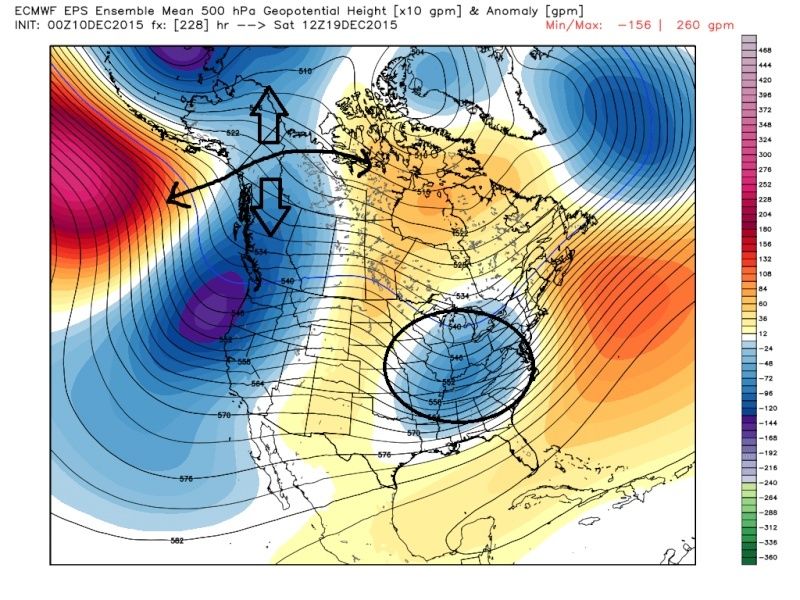
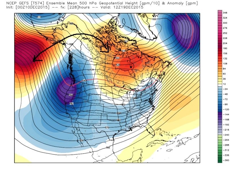
Some interesting developments in the 10 day range on todays model runs. Both the EURO and GFS are trying to pop positive heights in the circled area. If a ridge truly does develop there it would push the eastern ridge south and east, as well as the baroclinic zone. This could allow cold air to reach the coast near Christmas. This only happens if the magnitude of this ridge, or -EPO, strengthens and tries to extend poleward. We'll see how this looks by the weekend. Tonight, this feature left me going "hmmmm"
_________________
_______________________________________________________________________________________________________
CLICK HERE to view NJ Strong Snowstorm Classifications
Frank_Wx- Godzilla Seeker
- Posts : 21305
Reputation : 328
Join date : 2013-01-05
Age : 31
Location : Jersey City, NJ -
Re: Long Range Thread 9.0
![]() by amugs Wed Dec 09, 2015 10:59 pm
by amugs Wed Dec 09, 2015 10:59 pm
18z

12z

_________________
Mugs
AKA:King: Snow Weenie
Self Proclaimed
WINTER 2014-15 : 55.12" +.02 for 6 coatings (avg. 35")
WINTER 2015-16 Total - 29.8" (Avg 35")
WINTER 2016-17 : 39.5" so far
amugs- Advanced Forecaster - Mod
- Posts : 15093
Reputation : 213
Join date : 2013-01-07
Age : 54
Location : Hillsdale,NJ
Re: Long Range Thread 9.0
![]() by Snow88 Wed Dec 09, 2015 11:46 pm
by Snow88 Wed Dec 09, 2015 11:46 pm

Snow88- Senior Enthusiast
- Posts : 2193
Reputation : 4
Join date : 2013-01-09
Age : 35
Location : Brooklyn, NY
Re: Long Range Thread 9.0
![]() by NjWeatherGuy Thu Dec 10, 2015 7:04 am
by NjWeatherGuy Thu Dec 10, 2015 7:04 am
http://mag.ncep.noaa.gov/Image.php?fhr=219&image=data%2Fgfs%2F06%2Fgfs_namer_219_850_temp_mslp_precip.gif&model=gfs&area=namer¶m=850_temp_mslp_precip&group=Model+Guidance&preselected_formatted_cycle_date=20151210+06+UTC&imageSize=M&ps=area
NjWeatherGuy- Advanced Forecaster
- Posts : 4100
Reputation : 28
Join date : 2013-01-06
Location : Belle Mead, NJ
Re: Long Range Thread 9.0
![]() by sroc4 Thu Dec 10, 2015 7:22 am
by sroc4 Thu Dec 10, 2015 7:22 am
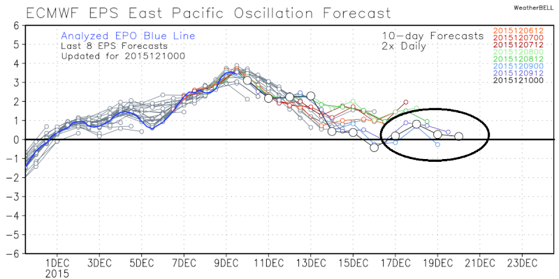
This far out I much prefer to look at the trends of 51model and the avg of what all 51 are saying, (which is what the ensemble mean is aka EPS aka European ensemble mean or the GEFS which is the GFS ensemble), than the operational which is only one run twice a day for the euro or 4 times a day for the GFS, although the trends of the operational models are important too. And of course the Canadian is also looked at and evaluated along with the others for the big picture.
EPS cont to hint at a trough moving into the E during this time frame. We need to see the spread in the negatives(blue colors) up into NW Canada and Eastern Alaska trend more concentrated N and S of that region. This will allow the Positives to hopefully build into this region.
 " />
" />You can see that the EPS is trying at least to get to a neutral EPO in that time frame. Hopefully it cont to trend towards negative
 " />
" />Vs the Euro OP: decent ridging into western Canada and more trough in the east on last nights run, but unfort is still changing quite drastically from run to run at 500mb. At least the trend cont to be more trough in the east:
Last nights 00z
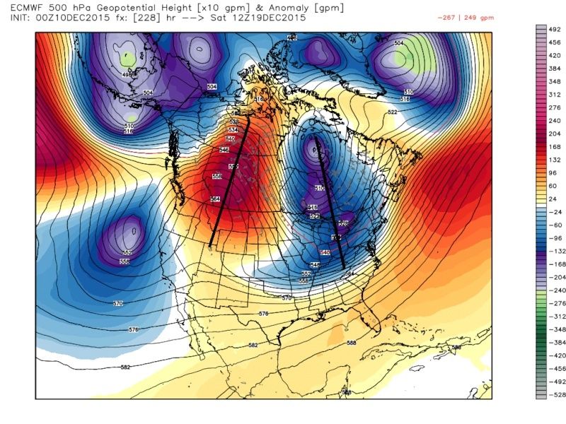 " />
" />Yesterdays 12z
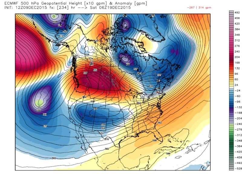 " />
" />GEFS are also hinting at some energy cutting underneath the ridging in Canada placing a trough into the east, but as you can see here they already have the positive heights into our EPO region. This is vital. This leads to a HP system to develop over central Canada that would provide a source for cold air to begin to try and drain into the central and eastern CONUS as I indicated in my write up yesterday.
 " />
" />GEFS have the EPO trending towards slight negative but have a pretty wide spread at the moment:
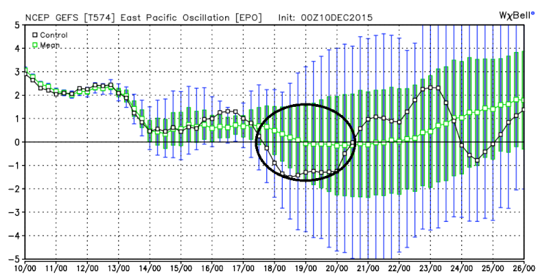 " />
" />Again we have a long way to go here. This is by no means an ideal set up, but this is a set up that can produce snow in the east if timing is right. Things will have to be pretty perfectly timed to have it workout so my confidence is still low for a snow storm at this time. My confidence is mod; however, that we see temps that are below normal.
_________________
"In weather and in life, there's no winning and losing; there's only winning and learning."
WINTER 2012/2013 TOTALS 43.65"WINTER 2017/2018 TOTALS 62.85" WINTER 2022/2023 TOTALS 4.9"
WINTER 2013/2014 TOTALS 64.85"WINTER 2018/2019 TOTALS 14.25" WINTER 2023/2024 TOTALS 13.1"
WINTER 2014/2015 TOTALS 71.20"WINTER 2019/2020 TOTALS 6.35"
WINTER 2015/2016 TOTALS 35.00"WINTER 2020/2021 TOTALS 37.75"
WINTER 2016/2017 TOTALS 42.25"WINTER 2021/2022 TOTALS 31.65"
sroc4- Admin
- Posts : 8331
Reputation : 301
Join date : 2013-01-07
Location : Wading River, LI
Re: Long Range Thread 9.0
![]() by Snow88 Thu Dec 10, 2015 8:32 am
by Snow88 Thu Dec 10, 2015 8:32 am
Snow88- Senior Enthusiast
- Posts : 2193
Reputation : 4
Join date : 2013-01-09
Age : 35
Location : Brooklyn, NY
Re: Long Range Thread 9.0
![]() by jmanley32 Thu Dec 10, 2015 8:55 am
by jmanley32 Thu Dec 10, 2015 8:55 am
jmanley32- Senior Enthusiast
- Posts : 20517
Reputation : 108
Join date : 2013-12-12
Age : 42
Location : Yonkers, NY
Re: Long Range Thread 9.0
![]() by HectorO Thu Dec 10, 2015 12:15 pm
by HectorO Thu Dec 10, 2015 12:15 pm

HectorO- Pro Enthusiast

- Posts : 959
Reputation : 27
Join date : 2013-01-11
Re: Long Range Thread 9.0
![]() by sroc4 Thu Dec 10, 2015 12:38 pm
by sroc4 Thu Dec 10, 2015 12:38 pm
HectorO wrote:It's my birthday! I think I might rock short sleeve shirt today LOL. Maybe tan this weekend.
Fabulous long range analysis Hector..lol..and Happy Birthday!
_________________
"In weather and in life, there's no winning and losing; there's only winning and learning."
WINTER 2012/2013 TOTALS 43.65"WINTER 2017/2018 TOTALS 62.85" WINTER 2022/2023 TOTALS 4.9"
WINTER 2013/2014 TOTALS 64.85"WINTER 2018/2019 TOTALS 14.25" WINTER 2023/2024 TOTALS 13.1"
WINTER 2014/2015 TOTALS 71.20"WINTER 2019/2020 TOTALS 6.35"
WINTER 2015/2016 TOTALS 35.00"WINTER 2020/2021 TOTALS 37.75"
WINTER 2016/2017 TOTALS 42.25"WINTER 2021/2022 TOTALS 31.65"
sroc4- Admin
- Posts : 8331
Reputation : 301
Join date : 2013-01-07
Location : Wading River, LI
Re: Long Range Thread 9.0
![]() by amugs Thu Dec 10, 2015 12:43 pm
by amugs Thu Dec 10, 2015 12:43 pm
HectorO wrote:It's my birthday! I think I might rock short sleeve shirt today LOL. Maybe tan this weekend.
Happy Birthday!! Bust out the baby oil!!
_________________
Mugs
AKA:King: Snow Weenie
Self Proclaimed
WINTER 2014-15 : 55.12" +.02 for 6 coatings (avg. 35")
WINTER 2015-16 Total - 29.8" (Avg 35")
WINTER 2016-17 : 39.5" so far
amugs- Advanced Forecaster - Mod
- Posts : 15093
Reputation : 213
Join date : 2013-01-07
Age : 54
Location : Hillsdale,NJ
Re: Long Range Thread 9.0
![]() by algae888 Thu Dec 10, 2015 1:06 pm
by algae888 Thu Dec 10, 2015 1:06 pm
Happy birthday hector! Enjoy the warm weather. I don't mind it warm as long as the sun's out.HectorO wrote:It's my birthday! I think I might rock short sleeve shirt today LOL. Maybe tan this weekend.
algae888- Advanced Forecaster
- Posts : 5311
Reputation : 46
Join date : 2013-02-05
Age : 61
Location : mt. vernon, new york
Re: Long Range Thread 9.0
![]() by NjWeatherGuy Thu Dec 10, 2015 1:19 pm
by NjWeatherGuy Thu Dec 10, 2015 1:19 pm
NjWeatherGuy- Advanced Forecaster
- Posts : 4100
Reputation : 28
Join date : 2013-01-06
Location : Belle Mead, NJ
Page 16 of 40 • 1 ... 9 ... 15, 16, 17 ... 28 ... 40 ![]()
|
|
|