
 Search
Long Range Thread 9.0
Page 9 of 40 •  1 ... 6 ... 8, 9, 10 ... 24 ... 40
 ![]()
Re: Long Range Thread 9.0
![]() by rb924119 Tue Dec 01, 2015 8:06 am
by rb924119 Tue Dec 01, 2015 8:06 am
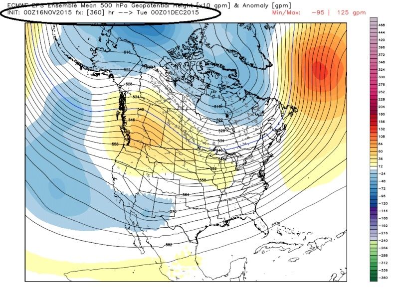
Frank_Wx wrote:Word around the weather world tonight is about how awful the latest EURO weeklies look. Here's some images 1 week apart from eachother. Take note of time stamps.
And to be honest, I'm not really thrilled about the look they give between Christmas and New Years. Luckily that's still pretty far out for changes to still happen.


Hey Frank, all hope may not be lost. When taken at face value, no; it looks like even the end of December is going to H@ll in a hand basket. BUT, take notice of the trends of the 500 hPa positive anomalies. They started in the northern Midwest; this latest run the core is now centered right near 60N. The trend is moving the right direction; toward the pole. Even in the GooFuS, this trend is evident. Why am I bringing this up? Here's why:

Look at the winds and fluxes toward mid-month......winds start dropping and fluxes start increasing, and you can also see the rises in heights. Also notice the time period; both on your graphics and mine, the time period is mid-month. Remember when all that snow cover started to rapidly stack up in the NH, specifically Siberia? Mid-month of October through the present. I think we might be seeing the models attempting to pick up on these vertical fluxes in the long range. You can also see the trends in the teleconnections, for the most part, heading in the right directions: NAO/AO/EPO trending toward negative values. The PNA is the only uncooperative one, but I think that could end up reversing if we start to see this consistently showing up.
rb924119- Meteorologist

- Posts : 6890
Join date : 2013-02-06
Re: Long Range Thread 9.0
![]() by amugs Tue Dec 01, 2015 8:45 am
by amugs Tue Dec 01, 2015 8:45 am
amugs- Advanced Forecaster - Mod

- Posts : 15093
Join date : 2013-01-07
Re: Long Range Thread 9.0
![]() by sroc4 Tue Dec 01, 2015 8:50 am
by sroc4 Tue Dec 01, 2015 8:50 am
 " />
" />But this is what the 500mb pattern actually looks like as of this mornings run hr 0 for 00z Dec1st. HUGE differences.
 " />
" />With the SOI still in crash mode, latest daily value -22.80, there is def something going to happen in the atmosphere that will take the models a little time to catch onto. It may trend even worse given the strength of some of the main drivers here, but the LR is the LR and more often than not what you see in the LR is not exactly what you get, for better or worse.
_________________
"In weather and in life, there's no winning and losing; there's only winning and learning."
WINTER 2012/2013 TOTALS 43.65"WINTER 2017/2018 TOTALS 62.85" WINTER 2022/2023 TOTALS 4.9"
WINTER 2013/2014 TOTALS 64.85"WINTER 2018/2019 TOTALS 14.25" WINTER 2023/2024 TOTALS 13.1"
WINTER 2014/2015 TOTALS 71.20"WINTER 2019/2020 TOTALS 6.35"
WINTER 2015/2016 TOTALS 35.00"WINTER 2020/2021 TOTALS 37.75"
WINTER 2016/2017 TOTALS 42.25"WINTER 2021/2022 TOTALS 31.65"

sroc4- Admin

- Posts : 8331
Reputation : 301
Join date : 2013-01-07
Location : Wading River, LI
Re: Long Range Thread 9.0
![]() by Frank_Wx Tue Dec 01, 2015 9:36 am
by Frank_Wx Tue Dec 01, 2015 9:36 am
rb924119 wrote:Frank_Wx wrote:Word around the weather world tonight is about how awful the latest EURO weeklies look. Here's some images 1 week apart from eachother. Take note of time stamps.
And to be honest, I'm not really thrilled about the look they give between Christmas and New Years. Luckily that's still pretty far out for changes to still happen.
Hey Frank, all hope may not be lost. When taken at face value, no; it looks like even the end of December is going to H@ll in a hand basket. BUT, take notice of the trends of the 500 hPa positive anomalies. They started in the northern Midwest; this latest run the core is now centered right near 60N. The trend is moving the right direction; toward the pole. Even in the GooFuS, this trend is evident. Why am I bringing this up? Here's why:
Look at the winds and fluxes toward mid-month......winds start dropping and fluxes start increasing, and you can also see the rises in heights. Also notice the time period; both on your graphics and mine, the time period is mid-month. Remember when all that snow cover started to rapidly stack up in the NH, specifically Siberia? Mid-month of October through the present. I think we might be seeing the models attempting to pick up on these vertical fluxes in the long range. You can also see the trends in the teleconnections, for the most part, heading in the right directions: NAO/AO/EPO trending toward negative values. The PNA is the only uncooperative one, but I think that could end up reversing if we start to see this consistently showing up.
There's a short term spike in EPV at 10hPa, but the magnitude is fairly weak. We want to see those arrows point poleward and show greater impact. Geopotential heights in the Stratosphere suggest we're in a wave 1 event but the warmth I'm seeing at 10-30mb doesn't seem impressive enough to displace the Strato PV at this time.
There's positive signs I'm seeing in the LR though. I'm still in favor of a pattern change taking place late this month, around New Year, or early January.
_________________
_______________________________________________________________________________________________________
CLICK HERE to view NJ Strong Snowstorm Classifications

Frank_Wx- Godzilla Seeker
- Posts : 21305
Reputation : 328
Join date : 2013-01-05
Age : 31
Location : Jersey City, NJ -

Re: Long Range Thread 9.0
![]() by amugs Tue Dec 01, 2015 12:20 pm
by amugs Tue Dec 01, 2015 12:20 pm
CANSIPS FOR JAN ON NOV 1
.png)
CANSIPS FOR JAN ON DEC 1
.png)
WHAT DO YOU SAY NOW MR HEAT MISER!!!
2M TEMPS - BOOOOOMM!!
.png)
OH ANN LETS GO PRECIP - CP, DOC, SNOW247 - BETTER THAN LAST RUNS!
.png)
_________________
Mugs
AKA:King: Snow Weenie
Self Proclaimed
WINTER 2014-15 : 55.12" +.02 for 6 coatings (avg. 35")
WINTER 2015-16 Total - 29.8" (Avg 35")
WINTER 2016-17 : 39.5" so far

amugs- Advanced Forecaster - Mod
- Posts : 15093
Reputation : 213
Join date : 2013-01-07
Age : 54
Location : Hillsdale,NJ
Re: Long Range Thread 9.0
![]() by CPcantmeasuresnow Tue Dec 01, 2015 12:44 pm
by CPcantmeasuresnow Tue Dec 01, 2015 12:44 pm

CPcantmeasuresnow- Wx Statistician Guru

- Posts : 7274
Reputation : 230
Join date : 2013-01-07
Age : 103
Location : Eastern Orange County, NY
Re: Long Range Thread 9.0
![]() by amugs Tue Dec 01, 2015 1:01 pm
by amugs Tue Dec 01, 2015 1:01 pm
CPcantmeasuresnow wrote:Mugs - As per your January maps, normal to slightly below average January temps, and above average January precip, should equal above average snowfall. We shall see, but I'm not holding my breath.
Yes we shall but as Sroc pointed out that the models are catching up to what is happening in our atmosphere and almost always lag -with taht said it is bette rtrending this way than the other and as the saying goes - the Trend is our Friend!!!
_________________
Mugs
AKA:King: Snow Weenie
Self Proclaimed
WINTER 2014-15 : 55.12" +.02 for 6 coatings (avg. 35")
WINTER 2015-16 Total - 29.8" (Avg 35")
WINTER 2016-17 : 39.5" so far
amugs- Advanced Forecaster - Mod
- Posts : 15093
Reputation : 213
Join date : 2013-01-07
Age : 54
Location : Hillsdale,NJ
Re: Long Range Thread 9.0
![]() by nutleyblizzard Tue Dec 01, 2015 1:05 pm
by nutleyblizzard Tue Dec 01, 2015 1:05 pm

nutleyblizzard- Senior Enthusiast

- Posts : 1952
Reputation : 41
Join date : 2014-01-30
Age : 58
Location : Nutley, new jersey
Re: Long Range Thread 9.0
![]() by rb924119 Tue Dec 01, 2015 1:12 pm
by rb924119 Tue Dec 01, 2015 1:12 pm
Frank_Wx wrote:rb924119 wrote:Frank_Wx wrote:Word around the weather world tonight is about how awful the latest EURO weeklies look. Here's some images 1 week apart from eachother. Take note of time stamps.
And to be honest, I'm not really thrilled about the look they give between Christmas and New Years. Luckily that's still pretty far out for changes to still happen.
Hey Frank, all hope may not be lost. When taken at face value, no; it looks like even the end of December is going to H@ll in a hand basket. BUT, take notice of the trends of the 500 hPa positive anomalies. They started in the northern Midwest; this latest run the core is now centered right near 60N. The trend is moving the right direction; toward the pole. Even in the GooFuS, this trend is evident. Why am I bringing this up? Here's why:
Look at the winds and fluxes toward mid-month......winds start dropping and fluxes start increasing, and you can also see the rises in heights. Also notice the time period; both on your graphics and mine, the time period is mid-month. Remember when all that snow cover started to rapidly stack up in the NH, specifically Siberia? Mid-month of October through the present. I think we might be seeing the models attempting to pick up on these vertical fluxes in the long range. You can also see the trends in the teleconnections, for the most part, heading in the right directions: NAO/AO/EPO trending toward negative values. The PNA is the only uncooperative one, but I think that could end up reversing if we start to see this consistently showing up.
There's a short term spike in EPV at 10hPa, but the magnitude is fairly weak. We want to see those arrows point poleward and show greater impact. Geopotential heights in the Stratosphere suggest we're in a wave 1 event but the warmth I'm seeing at 10-30mb doesn't seem impressive enough to displace the Strato PV at this time.
There's positive signs I'm seeing in the LR though. I'm still in favor of a pattern change taking place late this month, around New Year, or early January.
Totally agree. BUT my point is that we are seeing signs of something that MIGHT be coming. I'm not saying that future runs don't start trending and go back to what we have been seeing, but I think it's certainly something to watch over the next week or so to see how the trends go. That's all I'm saying. But with regard to the longggggg range, I agree.....again haha
rb924119- Meteorologist
- Posts : 6890
Reputation : 194
Join date : 2013-02-06
Age : 32
Location : Greentown, Pa
Re: Long Range Thread 9.0
![]() by Frank_Wx Tue Dec 01, 2015 1:28 pm
by Frank_Wx Tue Dec 01, 2015 1:28 pm
amugs wrote:Well looky here peps - thngs are a changing as per the changes from tehse dates - kudos to SROC for always harping on this point an dpointing it at!!
CANSIPS FOR JAN ON NOV 1
CANSIPS FOR JAN ON DEC 1
WHAT DO YOU SAY NOW MR HEAT MISER!!!
2M TEMPS - BOOOOOMM!!
OH ANN LETS GO PRECIP - CP, DOC, SNOW247 - BETTER THAN LAST RUNS!
I am not confident in this model - have not even heard of it to be honest - but I like the time frame it's signaling for a pattern change to occur. Within the next 7-14 days, we have to see exactly where the tropical forcing sets up. Will it be enough to displace the AK vortex and allow for an anomalous Aleutian trough to develop? If so, the EPO has a good chance of going negative and this could be the Tropospheric change we need to feedback into the Stratosphere and eventually displace / split the PV.
_________________
_______________________________________________________________________________________________________
CLICK HERE to view NJ Strong Snowstorm Classifications
Frank_Wx- Godzilla Seeker
- Posts : 21305
Reputation : 328
Join date : 2013-01-05
Age : 31
Location : Jersey City, NJ -
Re: Long Range Thread 9.0
![]() by amugs Tue Dec 01, 2015 1:31 pm
by amugs Tue Dec 01, 2015 1:31 pm
@ Frank, CanSIPS is the CMC from the Canadian - Levi Cowan, DT, WeatherBell all use this model.
Here is a link on it - https://weather.gc.ca/saisons/howto_seasonal_coupled_e.html
Seems to be the best chance of displacing or splitting vortex is going to come from the trop forcing out near the dateline - pretty crazy. Where is Thor when you need him?
_________________
Mugs
AKA:King: Snow Weenie
Self Proclaimed
WINTER 2014-15 : 55.12" +.02 for 6 coatings (avg. 35")
WINTER 2015-16 Total - 29.8" (Avg 35")
WINTER 2016-17 : 39.5" so far
amugs- Advanced Forecaster - Mod
- Posts : 15093
Reputation : 213
Join date : 2013-01-07
Age : 54
Location : Hillsdale,NJ
Re: Long Range Thread 9.0
![]() by Frank_Wx Tue Dec 01, 2015 9:13 pm
by Frank_Wx Tue Dec 01, 2015 9:13 pm
_________________
_______________________________________________________________________________________________________
CLICK HERE to view NJ Strong Snowstorm Classifications
Frank_Wx- Godzilla Seeker
- Posts : 21305
Reputation : 328
Join date : 2013-01-05
Age : 31
Location : Jersey City, NJ -
Re: Long Range Thread 9.0
![]() by NjWeatherGuy Tue Dec 01, 2015 10:14 pm
by NjWeatherGuy Tue Dec 01, 2015 10:14 pm

NjWeatherGuy- Advanced Forecaster

- Posts : 4100
Reputation : 28
Join date : 2013-01-06
Location : Belle Mead, NJ
Re: Long Range Thread 9.0
![]() by NjWeatherGuy Wed Dec 02, 2015 12:52 am
by NjWeatherGuy Wed Dec 02, 2015 12:52 am
http://meteocentre.com/models/explorateur.php?lang=en&map=na&run=00&mod=gemglb&stn=PNMPR&comp=1&run2=00&mod2=gemglb&stn2=PNMPR&hh2=120&fixhh=1&stn2_type=prog&mode=latest&yyyy=latest&mm=latest&dd=latest&hh=132
NjWeatherGuy- Advanced Forecaster
- Posts : 4100
Reputation : 28
Join date : 2013-01-06
Location : Belle Mead, NJ
Re: Long Range Thread 9.0
![]() by Frank_Wx Wed Dec 02, 2015 6:12 am
by Frank_Wx Wed Dec 02, 2015 6:12 am
NjWeatherGuy wrote:Uh, guys, I think the Canadian just went to a snowstorm on the 8th if im seeing this right, hr 132.
http://meteocentre.com/models/explorateur.php?lang=en&map=na&run=00&mod=gemglb&stn=PNMPR&comp=1&run2=00&mod2=gemglb&stn2=PNMPR&hh2=120&fixhh=1&stn2_type=prog&mode=latest&yyyy=latest&mm=latest&dd=latest&hh=132
No, that's rain. 540 line is in the Great Lakes.
_________________
_______________________________________________________________________________________________________
CLICK HERE to view NJ Strong Snowstorm Classifications
Frank_Wx- Godzilla Seeker
- Posts : 21305
Reputation : 328
Join date : 2013-01-05
Age : 31
Location : Jersey City, NJ -
Re: Long Range Thread 9.0
![]() by algae888 Wed Dec 02, 2015 8:06 am
by algae888 Wed Dec 02, 2015 8:06 am

heading in the right direction. some hope for January.
Last edited by algae888 on Wed Dec 02, 2015 8:08 am; edited 1 time in total

algae888- Advanced Forecaster
- Posts : 5311
Reputation : 46
Join date : 2013-02-05
Age : 61
Location : mt. vernon, new york
Re: Long Range Thread 9.0
![]() by Snow88 Wed Dec 02, 2015 8:06 am
by Snow88 Wed Dec 02, 2015 8:06 am
Yesterday : -22.80
Today : - 33.68
https://www.longpaddock.qld.gov.au/seasonalclimateoutlook/southernoscillationindex/

Snow88- Senior Enthusiast
- Posts : 2193
Reputation : 4
Join date : 2013-01-09
Age : 35
Location : Brooklyn, NY
Re: Long Range Thread 9.0
![]() by algae888 Wed Dec 02, 2015 9:42 am
by algae888 Wed Dec 02, 2015 9:42 am
algae888- Advanced Forecaster
- Posts : 5311
Reputation : 46
Join date : 2013-02-05
Age : 61
Location : mt. vernon, new york
Re: Long Range Thread 9.0
![]() by Guest Wed Dec 02, 2015 10:10 am
by Guest Wed Dec 02, 2015 10:10 am
This "storm" so far has given me a whopping .17 inches and nothing showing up downstream on the radar heading this way, while the LHV and NNJ make out again
Hopefully this is not a preview of the winter once it gets established next month???
Guest- Guest
Re: Long Range Thread 9.0
![]() by amugs Wed Dec 02, 2015 10:16 am
by amugs Wed Dec 02, 2015 10:16 am
algae888 wrote:Today's olr map shows a lot of convection in the Indian Ocean and also around the Date Line however most of that is in the southern hemisphere which is unfavorable for our area. Steve D feels that the conviction at the Date Line will move northward and help set up a more favorable pattern for us by displacing the Alaskan vortex and placing it south of the Aleutians. This process is probably going to be slow and we probably have to wait till at least sometime next week before we should see hints of the pattern change and maybe longer.
This displacement of this PV as per the Euro seasonal and CanSIPS maps are to take place late Dec and by mid Jan - for a back loaded winter this is what occurs. The convection at the dateline is a good sign and expectations for a bang bang Dec by many were not on the board for this winter. The same routine happened last year and we thought we never were going to get out of this "boot leg" type pattern and look what happened. The pattern needs time to evolve and it may take baby steps but eventually we will get there - back loaded means about 45 days away and THAT is a boat load of time for changes to occur. My friend and ex student who is a Lydon State Alum (Alex ?). pro met who worked for NOAA in Alaska for 8 years and now is working for meteostar in Upstate NY said to me the other day that he expects things to change over to more winter like condition by the first week of Jan (4-10th) time frame. As he said "Winter atmospheric conditions take longer to come together sometimes but as we enter deeper into winter all the factors do come together". I take his word.
_________________
Mugs
AKA:King: Snow Weenie
Self Proclaimed
WINTER 2014-15 : 55.12" +.02 for 6 coatings (avg. 35")
WINTER 2015-16 Total - 29.8" (Avg 35")
WINTER 2016-17 : 39.5" so far
amugs- Advanced Forecaster - Mod
- Posts : 15093
Reputation : 213
Join date : 2013-01-07
Age : 54
Location : Hillsdale,NJ
Re: Long Range Thread 9.0
![]() by amugs Wed Dec 02, 2015 10:19 am
by amugs Wed Dec 02, 2015 10:19 am
syosnow94 wrote:Besides some of the people on this forum beginning to get nervous about a non-winter because of how warm it has been and the forecast going forward, I am nervous about winter for a different reason. I am a BIG believer in patterns, and so far the last 3 rain storms for my area including this one have been a total BUST. I have received less than half of the forecasted rainfall from each one, while areas N/W have exceeded expectations.
This "storm" so far has given me a whopping .17 inches and nothing showing up downstream on the radar heading this way, while the LHV and NNJ make out again
Hopefully this is not a preview of the winter once it gets established next month???
About time the trend has reversed course -
_________________
Mugs
AKA:King: Snow Weenie
Self Proclaimed
WINTER 2014-15 : 55.12" +.02 for 6 coatings (avg. 35")
WINTER 2015-16 Total - 29.8" (Avg 35")
WINTER 2016-17 : 39.5" so far
amugs- Advanced Forecaster - Mod
- Posts : 15093
Reputation : 213
Join date : 2013-01-07
Age : 54
Location : Hillsdale,NJ
Re: Long Range Thread 9.0
![]() by sroc4 Wed Dec 02, 2015 11:00 am
by sroc4 Wed Dec 02, 2015 11:00 am
syosnow94 wrote:Besides some of the people on this forum beginning to get nervous about a non-winter because of how warm it has been and the forecast going forward, I am nervous about winter for a different reason. I am a BIG believer in patterns, and so far the last 3 rain storms for my area including this one have been a total BUST. I have received less than half of the forecasted rainfall from each one, while areas N/W have exceeded expectations.
This "storm" so far has given me a whopping .17 inches and nothing showing up downstream on the radar heading this way, while the LHV and NNJ make out again
Hopefully this is not a preview of the winter once it gets established next month???
I thought my rain guage was broken. I too had 0.23" measured yest into today. I do think the north and western areas will do better than us this year but I have confidence we still see above normal amts.
_________________
"In weather and in life, there's no winning and losing; there's only winning and learning."
WINTER 2012/2013 TOTALS 43.65"WINTER 2017/2018 TOTALS 62.85" WINTER 2022/2023 TOTALS 4.9"
WINTER 2013/2014 TOTALS 64.85"WINTER 2018/2019 TOTALS 14.25" WINTER 2023/2024 TOTALS 13.1"
WINTER 2014/2015 TOTALS 71.20"WINTER 2019/2020 TOTALS 6.35"
WINTER 2015/2016 TOTALS 35.00"WINTER 2020/2021 TOTALS 37.75"
WINTER 2016/2017 TOTALS 42.25"WINTER 2021/2022 TOTALS 31.65"
sroc4- Admin
- Posts : 8331
Reputation : 301
Join date : 2013-01-07
Location : Wading River, LI
Re: Long Range Thread 9.0
![]() by amugs Wed Dec 02, 2015 11:07 am
by amugs Wed Dec 02, 2015 11:07 am
500Map
.png)
Temps
.png)
Stressing early Jan through late March is the time frame and Feb fun fun fun!!
_________________
Mugs
AKA:King: Snow Weenie
Self Proclaimed
WINTER 2014-15 : 55.12" +.02 for 6 coatings (avg. 35")
WINTER 2015-16 Total - 29.8" (Avg 35")
WINTER 2016-17 : 39.5" so far
amugs- Advanced Forecaster - Mod
- Posts : 15093
Reputation : 213
Join date : 2013-01-07
Age : 54
Location : Hillsdale,NJ
Re: Long Range Thread 9.0
![]() by amugs Wed Dec 02, 2015 4:30 pm
by amugs Wed Dec 02, 2015 4:30 pm

Look at how the black like crashes come late Dec - woop woop!!

_________________
Mugs
AKA:King: Snow Weenie
Self Proclaimed
WINTER 2014-15 : 55.12" +.02 for 6 coatings (avg. 35")
WINTER 2015-16 Total - 29.8" (Avg 35")
WINTER 2016-17 : 39.5" so far
amugs- Advanced Forecaster - Mod
- Posts : 15093
Reputation : 213
Join date : 2013-01-07
Age : 54
Location : Hillsdale,NJ
Re: Long Range Thread 9.0
![]() by NjWeatherGuy Wed Dec 02, 2015 4:40 pm
by NjWeatherGuy Wed Dec 02, 2015 4:40 pm
https://weather.gc.ca/ensemble/charts_e.html?Hour=0&Day=0&RunTime=12&Type=pnm
NjWeatherGuy- Advanced Forecaster
- Posts : 4100
Reputation : 28
Join date : 2013-01-06
Location : Belle Mead, NJ
Re: Long Range Thread 9.0
![]() by NjWeatherGuy Wed Dec 02, 2015 4:42 pm
by NjWeatherGuy Wed Dec 02, 2015 4:42 pm
Frank_Wx wrote:NjWeatherGuy wrote:Uh, guys, I think the Canadian just went to a snowstorm on the 8th if im seeing this right, hr 132.
http://meteocentre.com/models/explorateur.php?lang=en&map=na&run=00&mod=gemglb&stn=PNMPR&comp=1&run2=00&mod2=gemglb&stn2=PNMPR&hh2=120&fixhh=1&stn2_type=prog&mode=latest&yyyy=latest&mm=latest&dd=latest&hh=132
No, that's rain. 540 line is in the Great Lakes.
Isnt the 540 the blue line, looks like it gets pulled into the storm from what I see, still could be too warm at the surface but it looks like thats below freezing aloft on last nights run.
NjWeatherGuy- Advanced Forecaster
- Posts : 4100
Reputation : 28
Join date : 2013-01-06
Location : Belle Mead, NJ
Re: Long Range Thread 9.0
![]() by amugs Wed Dec 02, 2015 4:48 pm
by amugs Wed Dec 02, 2015 4:48 pm
NjWeatherGuy wrote:Frank_Wx wrote:NjWeatherGuy wrote:Uh, guys, I think the Canadian just went to a snowstorm on the 8th if im seeing this right, hr 132.
http://meteocentre.com/models/explorateur.php?lang=en&map=na&run=00&mod=gemglb&stn=PNMPR&comp=1&run2=00&mod2=gemglb&stn2=PNMPR&hh2=120&fixhh=1&stn2_type=prog&mode=latest&yyyy=latest&mm=latest&dd=latest&hh=132
No, that's rain. 540 line is in the Great Lakes.
Isnt the 540 the blue line, looks like it gets pulled into the storm from what I see, still could be too warm at the surface but it looks like thats below freezing aloft on last nights run.
Tom from teh look sit does start to get pulled from the GL into it but seems to reside in Central PA - funnier things have happened with these beasts but looks to be rain for the coast. Time will tell.
Side not Nick Gregory last night on the 10PM news said there is possibility of a Nor'easter mid week.
_________________
Mugs
AKA:King: Snow Weenie
Self Proclaimed
WINTER 2014-15 : 55.12" +.02 for 6 coatings (avg. 35")
WINTER 2015-16 Total - 29.8" (Avg 35")
WINTER 2016-17 : 39.5" so far
amugs- Advanced Forecaster - Mod
- Posts : 15093
Reputation : 213
Join date : 2013-01-07
Age : 54
Location : Hillsdale,NJ
Page 9 of 40 • 1 ... 6 ... 8, 9, 10 ... 24 ... 40 ![]()
|
|
|