
 Search
Long Range Thread 9.0
Page 17 of 40 •  1 ... 10 ... 16, 17, 18 ... 28 ... 40
 ![]()
Re: Long Range Thread 9.0
![]() by algae888 Thu Dec 10, 2015 1:06 pm
by algae888 Thu Dec 10, 2015 1:06 pm
Happy birthday hector! Enjoy the warm weather. I don't mind it warm as long as the sun's out.HectorO wrote:It's my birthday! I think I might rock short sleeve shirt today LOL. Maybe tan this weekend.
algae888- Advanced Forecaster

- Posts : 5311
Join date : 2013-02-05
Re: Long Range Thread 9.0
![]() by NjWeatherGuy Thu Dec 10, 2015 1:19 pm
by NjWeatherGuy Thu Dec 10, 2015 1:19 pm
NjWeatherGuy- Advanced Forecaster
- Posts : 4100
Join date : 2013-01-06
Re: Long Range Thread 9.0
![]() by sroc4 Thu Dec 10, 2015 1:51 pm
by sroc4 Thu Dec 10, 2015 1:51 pm
NjWeatherGuy wrote:12z gfs shows never ending glcs, pattern doesnt change... SE ridge keeps pumping.
Ensembles may say differently. Plus take with a grain of salt. Upper levels cont to evolve to a deeper trough in the east around the 19th.
This is what it look liked for this time frame 4 days ago:

Now 00z first then todays 12z. Notice the trough in the east, the higher heights into alaska and the subtle -NAO look to the NE. The op along with the Ensembles cont to evolve. Not saying we get snow but not saying we arent.


_________________
"In weather and in life, there's no winning and losing; there's only winning and learning."
WINTER 2012/2013 TOTALS 43.65"WINTER 2017/2018 TOTALS 62.85" WINTER 2022/2023 TOTALS 4.9"
WINTER 2013/2014 TOTALS 64.85"WINTER 2018/2019 TOTALS 14.25" WINTER 2023/2024 TOTALS 13.1"
WINTER 2014/2015 TOTALS 71.20"WINTER 2019/2020 TOTALS 6.35"
WINTER 2015/2016 TOTALS 35.00"WINTER 2020/2021 TOTALS 37.75"
WINTER 2016/2017 TOTALS 42.25"WINTER 2021/2022 TOTALS 31.65"

sroc4- Admin

- Posts : 8331
Reputation : 301
Join date : 2013-01-07
Location : Wading River, LI
Re: Long Range Thread 9.0
![]() by HectorO Thu Dec 10, 2015 4:03 pm
by HectorO Thu Dec 10, 2015 4:03 pm
algae888 wrote:Happy birthday hector! Enjoy the warm weather. I don't mind it warm as long as the sun's out.HectorO wrote:It's my birthday! I think I might rock short sleeve shirt today LOL. Maybe tan this weekend.
Thank you!

HectorO- Pro Enthusiast

- Posts : 959
Reputation : 27
Join date : 2013-01-11
Re: Long Range Thread 9.0
![]() by amugs Thu Dec 10, 2015 4:31 pm
by amugs Thu Dec 10, 2015 4:31 pm
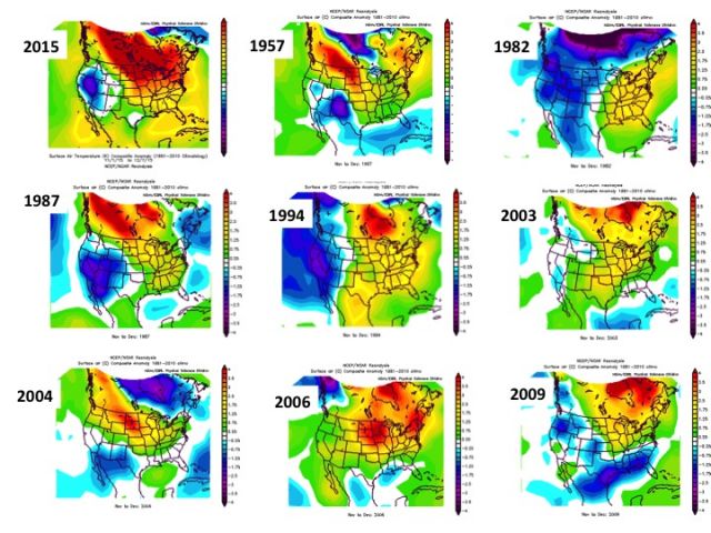
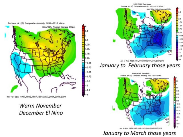
Warm N/D followed by this - everyone said Dec would be AN as I did as well BUT J-M we get colder not like last year cold I think and snowy. I stay steadfast on that. Pattern is tarting to evolve as Scott noted and I have said since the SOI crashed about 2 weeks ago. Following maps depict this evolution from N/D warmth to J-F, J-M colder and snowier pattern
_________________
Mugs
AKA:King: Snow Weenie
Self Proclaimed
WINTER 2014-15 : 55.12" +.02 for 6 coatings (avg. 35")
WINTER 2015-16 Total - 29.8" (Avg 35")
WINTER 2016-17 : 39.5" so far

amugs- Advanced Forecaster - Mod

- Posts : 15093
Reputation : 213
Join date : 2013-01-07
Age : 54
Location : Hillsdale,NJ
Re: Long Range Thread 9.0
![]() by skinsfan1177 Thu Dec 10, 2015 5:23 pm
by skinsfan1177 Thu Dec 10, 2015 5:23 pm
amugs wrote:Compliments of Joe D
Warm N/D followed by this - everyone said Dec would be AN as I did as well BUT J-M we get colder not like last year cold I think and snowy. I stay steadfast on that. Pattern is tarting to evolve as Scott noted and I have said since the SOI crashed about 2 weeks ago. Following maps depict this evolution from N/D warmth to J-F, J-M colder and snowier pattern
I hope so mugsy I feel if it doesn't most forecast will be a bust. But with that said I believe El Nino will weaken and I believe mid j-f we get the goods with possibly some big storms. Not as cold is fine we don't suppression depression. Also I always remember hearing that just being cold enough is when you get the good snows.

skinsfan1177- Senior Enthusiast

- Posts : 4485
Reputation : 35
Join date : 2013-01-07
Age : 46
Location : Point Pleasant Boro
Re: Long Range Thread 9.0
![]() by Frank_Wx Thu Dec 10, 2015 5:28 pm
by Frank_Wx Thu Dec 10, 2015 5:28 pm
sroc4 wrote:Quick update: Ensembles cont to hint at a storm signal or at least the potential for the coldest air of the season to arrive between Dec 18th-21st and 22nd-25th although there is still a long way to go.
This far out I much prefer to look at the trends of 51model and the avg of what all 51 are saying, (which is what the ensemble mean is aka EPS aka European ensemble mean or the GEFS which is the GFS ensemble), than the operational which is only one run twice a day for the euro or 4 times a day for the GFS, although the trends of the operational models are important too. And of course the Canadian is also looked at and evaluated along with the others for the big picture.
EPS cont to hint at a trough moving into the E during this time frame. We need to see the spread in the negatives(blue colors) up into NW Canada and Eastern Alaska trend more concentrated N and S of that region. This will allow the Positives to hopefully build into this region." />
You can see that the EPS is trying at least to get to a neutral EPO in that time frame. Hopefully it cont to trend towards negative" />
Vs the Euro OP: decent ridging into western Canada and more trough in the east on last nights run, but unfort is still changing quite drastically from run to run at 500mb. At least the trend cont to be more trough in the east:
Last nights 00z" />
Yesterdays 12z" />
GEFS are also hinting at some energy cutting underneath the ridging in Canada placing a trough into the east, but as you can see here they already have the positive heights into our EPO region. This is vital. This leads to a HP system to develop over central Canada that would provide a source for cold air to begin to try and drain into the central and eastern CONUS as I indicated in my write up yesterday." />
GEFS have the EPO trending towards slight negative but have a pretty wide spread at the moment:" />
Again we have a long way to go here. This is by no means an ideal set up, but this is a set up that can produce snow in the east if timing is right. Things will have to be pretty perfectly timed to have it workout so my confidence is still low for a snow storm at this time. My confidence is mod; however, that we see temps that are below normal.
Nice writeup. I mentioned the positive heights getting into the EPO domain so we're almost seeing the same thing. If there's a stout EPO ridge I would be a big believer in the cold between 18th and 25th. I haven't looked at any model yet today.
HectorO wrote:It's my birthday! I think I might rock short sleeve shirt today LOL. Maybe tan this weekend.
Happy birthday man. Hope it's a good one!
NjWeatherGuy wrote:12z gfs shows never ending glcs, pattern doesnt change... SE ridge keeps pumping.
Unfortunately, this is most likely to happen than not. Depends on the EPO ridge.
sroc4 wrote:NjWeatherGuy wrote:12z gfs shows never ending glcs, pattern doesnt change... SE ridge keeps pumping.
Ensembles may say differently. Plus take with a grain of salt. Upper levels cont to evolve to a deeper trough in the east around the 19th.
This is what it look liked for this time frame 4 days ago:
Now 00z first then todays 12z. Notice the trough in the east, the higher heights into alaska and the subtle -NAO look to the NE. The op along with the Ensembles cont to evolve. Not saying we get snow but not saying we arent.
I prefer the look on yesterday's model runs. This looks a bit more transient / progressive to me.
_________________
_______________________________________________________________________________________________________
CLICK HERE to view NJ Strong Snowstorm Classifications

Frank_Wx- Godzilla Seeker
- Posts : 21305
Reputation : 328
Join date : 2013-01-05
Age : 31
Location : Jersey City, NJ -

Re: Long Range Thread 9.0
![]() by Frank_Wx Thu Dec 10, 2015 6:47 pm
by Frank_Wx Thu Dec 10, 2015 6:47 pm

We're all aware this weekend will feature a massive cutter that will send temps soaring into the 60s. This time next week, according to the Weeklies and other guidance, another storm will cut due to the anomalous trough digging into the west. This time, there's going to be unseasonably colder air that follows behind it. But it will not last long. December 18th to MAYBE the 20th. No precip expected at this time either.
Day 14

From the 21st to Christmas Day, the Weeklies suggest we'll be around normal. This is interesting actually. Ridge in SE Canada helping to slow the flow (I'm basically Jay Z) down, with positive heights now showing up in the EPO domain over Alaska and western Canada. The bowling ball ULL still keeps the Southeast warm, but the mild temps don't reach our Latitude because of the aforementioned upper level features. I don't believe the air mass will be cold enough to support snow in this time frame, but it's GREAT to see the EPO try to go negative.
Day 21:

New Years Eve Godzilla? Hard to tell but you can see the influence of El Nino in this graphic. Canada is very warm and STJ tries to form a coastal storm. I'm still betting against the Arctic airmass here because lowest height anomalies continue to be bottled up in the Arctic. The ULL off the west could be amplifying the pattern too much. If that feature is real, I can definitely see the STJ getting active around this time.
Day 28:

Wild. And to be perfectly honest, I'm pretty happy to see the Weeklies get a bit nuts. To me, this is indicative of the pattern trying to change. By week 4, heights over Canada are not nearly as positive. The ULL travels along the southern tier of the country which raises heights over the western and central US. What's most important to take away here is the Aleutian trough. It's quite clear it's retrograded and a ridge is now over Alaska. This is pivotal in getting colder air to eastern NA, and you can already see that I'm eastern Canada. This could also lead to an advanced signal that Stratospheric Warming could take place between New Years and early January. This means a permanent pattern change - the one I talked about in my Winter Outlook - comes by week 3 or week 4 of January. Right in line with last season.
These were my interpretations of the Weeklies. My personal take, I think the winter pattern is in line to change by week 3 or week 4 of January. It could come sooner, but it's going to take time for Nino to weaken to moderate levels and for the extremely cold Stratosphere to suddenly warm. A SSWE should take place right after Christmas to week 1 of January. Not just the Weeklies, but other guidance insists on the Aleutian Low retrograding and for an EPO ridge to develop. In my Winter Outlook I called for a pattern change similar to last year's time frame. I'm a strong believer in this still.
_________________
_______________________________________________________________________________________________________
CLICK HERE to view NJ Strong Snowstorm Classifications
Frank_Wx- Godzilla Seeker
- Posts : 21305
Reputation : 328
Join date : 2013-01-05
Age : 31
Location : Jersey City, NJ -
Re: Long Range Thread 9.0
![]() by Frank_Wx Thu Dec 10, 2015 7:34 pm
by Frank_Wx Thu Dec 10, 2015 7:34 pm
_________________
_______________________________________________________________________________________________________
CLICK HERE to view NJ Strong Snowstorm Classifications
Frank_Wx- Godzilla Seeker
- Posts : 21305
Reputation : 328
Join date : 2013-01-05
Age : 31
Location : Jersey City, NJ -
Re: Long Range Thread 9.0
![]() by amugs Thu Dec 10, 2015 10:03 pm
by amugs Thu Dec 10, 2015 10:03 pm
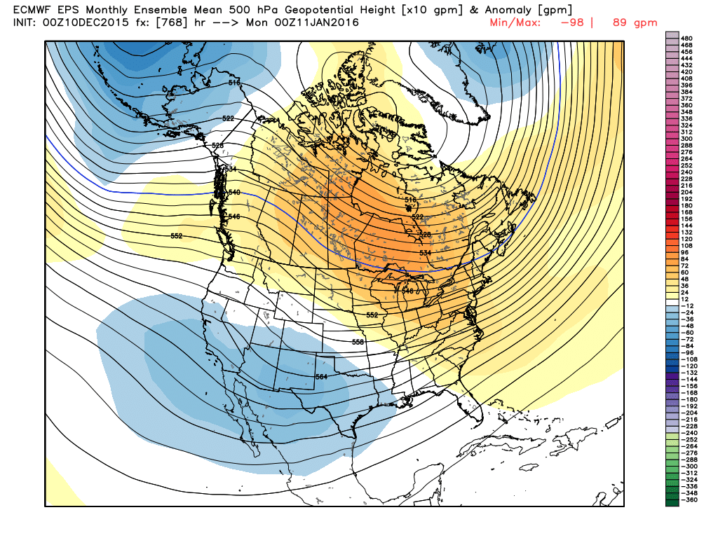
Frank_Wx wrote:I mistakenly posted the Controls instead of the Means of the Weekly EURO. No big deal cause idea is still the same by weeks 3 and 4. CA Ridge going from east to central Canada with higher heights sneaking into EPO domain. Also notice Aleutian trough retrograde.
Exactly what the EURO seasonal 500mb map showed in Jan . Then it goes SW of the Aleutians lets the heights build into BC/NW Can drops a trough in the SE and bazinga with the STJ.
-EPO,+PNA, -NAO and AO in the means
_________________
Mugs
AKA:King: Snow Weenie
Self Proclaimed
WINTER 2014-15 : 55.12" +.02 for 6 coatings (avg. 35")
WINTER 2015-16 Total - 29.8" (Avg 35")
WINTER 2016-17 : 39.5" so far
amugs- Advanced Forecaster - Mod
- Posts : 15093
Reputation : 213
Join date : 2013-01-07
Age : 54
Location : Hillsdale,NJ
Re: Long Range Thread 9.0
![]() by amugs Thu Dec 10, 2015 10:05 pm
by amugs Thu Dec 10, 2015 10:05 pm
skinsfan1177 wrote:amugs wrote:Compliments of Joe D
Warm N/D followed by this - everyone said Dec would be AN as I did as well BUT J-M we get colder not like last year cold I think and snowy. I stay steadfast on that. Pattern is tarting to evolve as Scott noted and I have said since the SOI crashed about 2 weeks ago. Following maps depict this evolution from N/D warmth to J-F, J-M colder and snowier pattern
I hope so mugsy I feel if it doesn't most forecast will be a bust. But with that said I believe El Nino will weaken and I believe mid j-f we get the goods with possibly some big storms. Not as cold is fine we don't suppression depression. Also I always remember hearing that just being cold enough is when you get the good snows.
25-30* is great for snow - preferably 27-29* gives you an awesome snow IMO.
_________________
Mugs
AKA:King: Snow Weenie
Self Proclaimed
WINTER 2014-15 : 55.12" +.02 for 6 coatings (avg. 35")
WINTER 2015-16 Total - 29.8" (Avg 35")
WINTER 2016-17 : 39.5" so far
amugs- Advanced Forecaster - Mod
- Posts : 15093
Reputation : 213
Join date : 2013-01-07
Age : 54
Location : Hillsdale,NJ
Re: Long Range Thread 9.0
![]() by snow247 Fri Dec 11, 2015 6:58 am
by snow247 Fri Dec 11, 2015 6:58 am

snow247- Pro Enthusiast
- Posts : 2417
Reputation : 0
Join date : 2014-08-27
Location : Mount Ivy, NY - Elevation 545'
Re: Long Range Thread 9.0
![]() by amugs Fri Dec 11, 2015 7:42 am
by amugs Fri Dec 11, 2015 7:42 am
snow247 wrote:Latest GFS and Euro have interior snow around day 7.
I'm Back!!!!!

Close here for the coast but more so interior as snow said:

_________________
Mugs
AKA:King: Snow Weenie
Self Proclaimed
WINTER 2014-15 : 55.12" +.02 for 6 coatings (avg. 35")
WINTER 2015-16 Total - 29.8" (Avg 35")
WINTER 2016-17 : 39.5" so far
amugs- Advanced Forecaster - Mod
- Posts : 15093
Reputation : 213
Join date : 2013-01-07
Age : 54
Location : Hillsdale,NJ
Re: Long Range Thread 9.0
![]() by sroc4 Fri Dec 11, 2015 9:04 am
by sroc4 Fri Dec 11, 2015 9:04 am
amugs wrote:snow247 wrote:Latest GFS and Euro have interior snow around day 7.
I'm Back!!!!!
Close here for the coast but more so interior as snow said:
ALMOST under 7 days out. I've been harping on this time frame for at least a cold shot into the east with the possibility of a storm if the ingredients were in the right place since my SOI comments. Chances still aren't ideal, but again will stress chances are def NOT zero either for a system on or near the coast. I will start to take any storm threat seriously when we are in the 5-7 day time frame and under. Encouraging to see it still around on models, and upper levels really are not that far off. Well see.
_________________
"In weather and in life, there's no winning and losing; there's only winning and learning."
WINTER 2012/2013 TOTALS 43.65"WINTER 2017/2018 TOTALS 62.85" WINTER 2022/2023 TOTALS 4.9"
WINTER 2013/2014 TOTALS 64.85"WINTER 2018/2019 TOTALS 14.25" WINTER 2023/2024 TOTALS 13.1"
WINTER 2014/2015 TOTALS 71.20"WINTER 2019/2020 TOTALS 6.35"
WINTER 2015/2016 TOTALS 35.00"WINTER 2020/2021 TOTALS 37.75"
WINTER 2016/2017 TOTALS 42.25"WINTER 2021/2022 TOTALS 31.65"
sroc4- Admin
- Posts : 8331
Reputation : 301
Join date : 2013-01-07
Location : Wading River, LI
Re: Long Range Thread 9.0
![]() by algae888 Fri Dec 11, 2015 9:32 am
by algae888 Fri Dec 11, 2015 9:32 am


while it will not get cold right after the cold front passes tues and wens., this low will then sit and spin for several days over Hudson bay and in response to this lp colder air will be drawn down from the arctic regions and a nice ridge out west and a deep trough over the Mississippi river valley will develop.


this trough will develop a low over the gom and this low will ride n/e into our area as currently modeled.


now the question becomes can the cold arrive at the right time and we snow? we shall see how this evolves in the coming days.

algae888- Advanced Forecaster
- Posts : 5311
Reputation : 46
Join date : 2013-02-05
Age : 61
Location : mt. vernon, new york
Re: Long Range Thread 9.0
![]() by algae888 Fri Dec 11, 2015 9:41 am
by algae888 Fri Dec 11, 2015 9:41 am
algae888- Advanced Forecaster
- Posts : 5311
Reputation : 46
Join date : 2013-02-05
Age : 61
Location : mt. vernon, new york
Re: Long Range Thread 9.0
![]() by docstox12 Fri Dec 11, 2015 10:10 am
by docstox12 Fri Dec 11, 2015 10:10 am

docstox12- Wx Statistician Guru

- Posts : 8507
Reputation : 222
Join date : 2013-01-07
Age : 73
Location : Monroe NY
Re: Long Range Thread 9.0
![]() by algae888 Fri Dec 11, 2015 10:27 am
by algae888 Fri Dec 11, 2015 10:27 am
Yes doc At least we have something to track within 7 days. it's unfortunate that we will not get any cold air with the first cold front that passes Monday night. if temperatures just got to normal Tuesday through Thursday we would have a really good shot at seeing some snow.docstox12 wrote:Good news, Al, will be nice if it happens to see a few flakes flying.It's been almost two months around here.
algae888- Advanced Forecaster
- Posts : 5311
Reputation : 46
Join date : 2013-02-05
Age : 61
Location : mt. vernon, new york
Re: Long Range Thread 9.0
![]() by amugs Fri Dec 11, 2015 11:07 am
by amugs Fri Dec 11, 2015 11:07 am
algae888 wrote:Yes doc At least we have something to track within 7 days. it's unfortunate that we will not get any cold air with the first cold front that passes Monday night. if temperatures just got to normal Tuesday through Thursday we would have a really good shot at seeing some snow.docstox12 wrote:Good news, Al, will be nice if it happens to see a few flakes flying.It's been almost two months around here.
Its going to happen you watch - Big momma has way of evening things out. model mayhem for the next few days so everyone just sit tight and let it play out. things are slowly eveolving. Cutters/LP's get log jammed in NE Can from the model runs - so we'll see i fthis gives us a 50/50 block to help the situation.
JB said last night he still likes this time frame as well - coast eehh but inland more so but don't rule it out.
_________________
Mugs
AKA:King: Snow Weenie
Self Proclaimed
WINTER 2014-15 : 55.12" +.02 for 6 coatings (avg. 35")
WINTER 2015-16 Total - 29.8" (Avg 35")
WINTER 2016-17 : 39.5" so far
amugs- Advanced Forecaster - Mod
- Posts : 15093
Reputation : 213
Join date : 2013-01-07
Age : 54
Location : Hillsdale,NJ
Re: Long Range Thread 9.0
![]() by Abba701 Fri Dec 11, 2015 12:54 pm
by Abba701 Fri Dec 11, 2015 12:54 pm
Abba701- Posts : 328
Reputation : 0
Join date : 2013-01-14
Re: Long Range Thread 9.0
![]() by rb924119 Fri Dec 11, 2015 1:26 pm
by rb924119 Fri Dec 11, 2015 1:26 pm
Take a look at the latest 500 hPa height anomalies from today's 12z GFS Op for the storm in question (17th/18th):
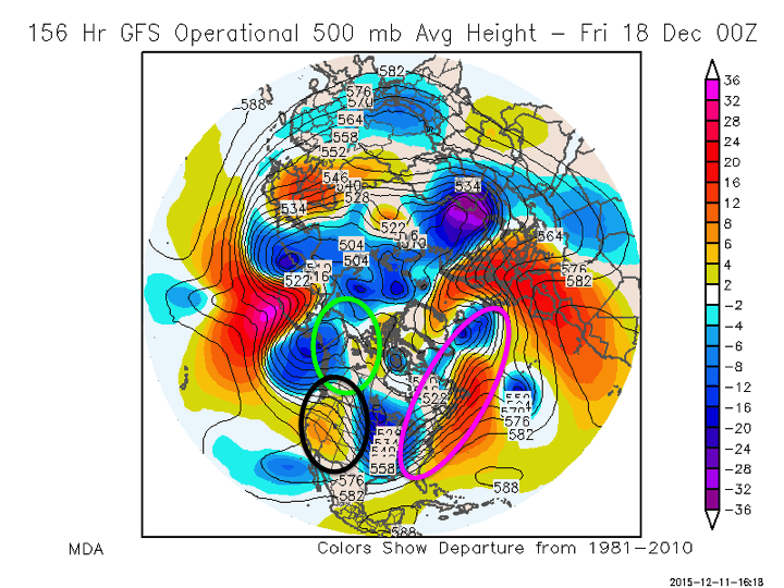 " />
" />Notice the three regions that I have circled in various colors. The first, working from upstream-down (west to east), in the green, denotes the EPO region. Notice how there are no colors, or even slightly cool colors in this region. While at first glance this appears to be a negative right off the bat, this has trended significantly better as off late, with more ridging (less cool colors) showing up here. The second region (black circle) denotes the PNA region, and in this look, we can all clearly see the warmer colors which signify ridging. This is another good sign for an East Coast system. Ok; 2-2 so far. Now let me direct your attention to the third circle in pink, which denotes some of the NAO region. Notice how flat, or zonal, the flow is, with cooler colors poleward (north) of warmer colors. This shows one of the issues that we have faced for the last few winters; a +NAO. Well, as Meatloaf put it; "2 outta 3 ain't bad", so we should still have a shot at this thing, right? I'm not so sure. Here's why. Take a look at the 500 hPa vorticity (energy) that will be responsible for whether or not we see something develop at all (same run, same time).....

The energy we are looking for is "centered" over the Ark-La-Tex region, but has a long tail that trails all the way back up into South-central Canada. Notice there is also a weak strip ahead of it; that's associated with the front itself. Under certain circumstances, we have gotten similar situations to work in the past, but I don't think this will be one of them. Assuming the PNA stays as is on the models, and we continue to see the EPO trend in what is typically a more favorable state (negative, with higher than normal heights, warmer colors/less cooler colors into Alaska), combined with the consistently progressive pattern we have been in and +NAO, then I THINK we will end up seeing this thing trend both offshore and weaker.
With those conditions and assumptions in place, and the excessively fast flow, seen by the very tight gradient of the black lines on the map above), there is no way for this energy to consolidate and ball up, and yield a decent event; even rain. I think we will see the final solution come to be a disorganized open wave that rides the warm side of the front, which gets pushed to our south, and we are left on the cold and dry side of it. Just my two cents....
rb924119- Meteorologist

- Posts : 6890
Reputation : 194
Join date : 2013-02-06
Age : 32
Location : Greentown, Pa
Re: Long Range Thread 9.0
![]() by rb924119 Fri Dec 11, 2015 1:30 pm
by rb924119 Fri Dec 11, 2015 1:30 pm

rb924119- Meteorologist
- Posts : 6890
Reputation : 194
Join date : 2013-02-06
Age : 32
Location : Greentown, Pa
Re: Long Range Thread 9.0
![]() by amugs Fri Dec 11, 2015 2:11 pm
by amugs Fri Dec 11, 2015 2:11 pm
People ready to cancel winter??
Read the link above - all in place as we go forward for another I feel great period of time incoming as we head deeper into winter. Evolution is starting, its going to come - Mid Januarish.
_________________
Mugs
AKA:King: Snow Weenie
Self Proclaimed
WINTER 2014-15 : 55.12" +.02 for 6 coatings (avg. 35")
WINTER 2015-16 Total - 29.8" (Avg 35")
WINTER 2016-17 : 39.5" so far
amugs- Advanced Forecaster - Mod
- Posts : 15093
Reputation : 213
Join date : 2013-01-07
Age : 54
Location : Hillsdale,NJ
Re: Long Range Thread 9.0
![]() by algae888 Fri Dec 11, 2015 2:25 pm
by algae888 Fri Dec 11, 2015 2:25 pm
mugs yes it was a good read and makes a lot of sense to me especially the impact the mjo has had on our weather so far. if you look at the euro ensembles for the mjo we are in a warm phase now but look at where it is taking us. a lot of members have it going to 7 and 8 which is good for our area. steve d has been all over this also in the last week or so.amugs wrote:http://www.lightinthestorm.com/archives/962
People ready to cancel winter??
Read the link above - all in place as we go forward for another I feel great period of time incoming as we head deeper into winter. Evolution is starting, its going to come - Mid Januarish.

algae888- Advanced Forecaster
- Posts : 5311
Reputation : 46
Join date : 2013-02-05
Age : 61
Location : mt. vernon, new york
Re: Long Range Thread 9.0
![]() by amugs Fri Dec 11, 2015 2:32 pm
by amugs Fri Dec 11, 2015 2:32 pm
_________________
Mugs
AKA:King: Snow Weenie
Self Proclaimed
WINTER 2014-15 : 55.12" +.02 for 6 coatings (avg. 35")
WINTER 2015-16 Total - 29.8" (Avg 35")
WINTER 2016-17 : 39.5" so far
amugs- Advanced Forecaster - Mod
- Posts : 15093
Reputation : 213
Join date : 2013-01-07
Age : 54
Location : Hillsdale,NJ
Re: Long Range Thread 9.0
![]() by nutleyblizzard Fri Dec 11, 2015 2:35 pm
by nutleyblizzard Fri Dec 11, 2015 2:35 pm
I agree with that analogy. I'm very confident in a pattern flip after the new year. This winter I believe will be remembered as a tale of two seasons. Right now we are in a very boring weather pattern; (for snow lovers anyway). We just have to be patient as Frank has mentioned on numerous occasions that this will be a gradual process toward a more wintry pattern. I can see a very active period commencing once we get into mid January right through February; extreme if our NAO goes negative too. I would like to see if a steady decline in our Nino develops in the coming days and weeks. The faster the better. That will help to hasten the pattern change.amugs wrote:http://www.lightinthestorm.com/archives/962
People ready to cancel winter??
Read the link above - all in place as we go forward for another I feel great period of time incoming as we head deeper into winter. Evolution is starting, its going to come - Mid Januarish.

nutleyblizzard- Senior Enthusiast
- Posts : 1952
Reputation : 41
Join date : 2014-01-30
Age : 58
Location : Nutley, new jersey
Re: Long Range Thread 9.0
![]() by sroc4 Fri Dec 11, 2015 2:38 pm
by sroc4 Fri Dec 11, 2015 2:38 pm
http://www.accuweather.com/en/weather-news/powerful-bering-sea-storm-potential-record-breaking-fairbanks-anchorage-alaska/54125652
Although you and Frank are probably correct, I will cont to point out that the probability of a LP at or near the coast that could produce white gold, most likely interior if at all, is not zero. I would put it at 25% ATT.
_________________
"In weather and in life, there's no winning and losing; there's only winning and learning."
WINTER 2012/2013 TOTALS 43.65"WINTER 2017/2018 TOTALS 62.85" WINTER 2022/2023 TOTALS 4.9"
WINTER 2013/2014 TOTALS 64.85"WINTER 2018/2019 TOTALS 14.25" WINTER 2023/2024 TOTALS 13.1"
WINTER 2014/2015 TOTALS 71.20"WINTER 2019/2020 TOTALS 6.35"
WINTER 2015/2016 TOTALS 35.00"WINTER 2020/2021 TOTALS 37.75"
WINTER 2016/2017 TOTALS 42.25"WINTER 2021/2022 TOTALS 31.65"
sroc4- Admin
- Posts : 8331
Reputation : 301
Join date : 2013-01-07
Location : Wading River, LI
Page 17 of 40 • 1 ... 10 ... 16, 17, 18 ... 28 ... 40 ![]()
|
|
|