Long Range Thread 9.0
+35
snowlover 12345
Snowfall
hyde345
Mathgod55
Dtone
weatherwatchermom
WOLVES1
elkiehound
devsman
Radz
Abba701
dkodgis
Quietace
Vinnydula
CPcantmeasuresnow
billg315
snow247
Math23x7
RJB8525
docstox12
jmanley32
HectorO
31MBP
NjWeatherGuy
rb924119
skinsfan1177
nutleyblizzard
Snow88
chief7
sroc4
aiannone
amugs
Frank_Wx
algae888
Dunnzoo
39 posters
Page 27 of 40
Page 27 of 40 •  1 ... 15 ... 26, 27, 28 ... 33 ... 40
 Re: Long Range Thread 9.0
He basically goes on to say that the only way we're going to get sustained cold and below normal temperatures here in the Northeast with such a strong El Nino is to get some kind of blocking. He did not reference anyone in particular whether it's the EPO AO or NAO.
http://www.meteonetwork.it/models/mjo/ is a good place to start. That's freely available. This is the link to the site he used for his data
http://www.meteonetwork.it/models/mjo/ is a good place to start. That's freely available. This is the link to the site he used for his data
algae888- Advanced Forecaster

- Posts : 5311
Join date : 2013-02-05
 Re: Long Range Thread 9.0
How can that be the other years we disnt have blocking and had sustained cold. El nino is declining
skinsfan1177- Senior Enthusiast

- Posts : 4485
Join date : 2013-01-07
 Re: Long Range Thread 9.0
algae888 wrote:Today's gfs has a significant ice storm for our northern and western suburbs on Monday which is 6 days out. it starts at snow and then turns to ice. not unrealistic as today's run has the high pressure which is very strong in a favorable place for cold air damming. would favor the interior over coastal locations though
sure does, placement of ice is very hard to pin down but of course our first winter wx event would have to be a ice storm right, plus thats the time frame when its supposed to get very windy too. heh fun times
Al if I am correct in that those numbers are liquid equivelant as stated in the image that shows about 2-5 inches of ice pellets/sleet for us fun.


jmanley32- Senior Enthusiast

- Posts : 20635
Reputation : 108
Join date : 2013-12-12
Age : 43
Location : Yonkers, NY
 Re: Long Range Thread 9.0
Skins last year we did have blocking it was in the eastern Pacific from the EPO however in strong El Nino years it's much harder to get that block sustained so we would need help from the AO or the NAO which is on the Atlantic side. As far is El Nino region 3.4 is + 2.9 today so it is not really weakening its more staying levelskinsfan1177 wrote:How can that be the other years we disnt have blocking and had sustained cold. El nino is declining

algae888- Advanced Forecaster

- Posts : 5311
Reputation : 46
Join date : 2013-02-05
Age : 62
Location : mt. vernon, new york
 Re: Long Range Thread 9.0
algae888 wrote:Skins last year we did have blocking it was in the eastern Pacific from the EPO however in strong El Nino years it's much harder to get that block sustained so we would need help from the AO or the NAO which is on the Atlantic side. As far is El Nino region 3.4 is + 2.9 today so it is not really weakening its more staying levelskinsfan1177 wrote:How can that be the other years we disnt have blocking and had sustained cold. El nino is declining
Got you thanks for explaining that to me.

skinsfan1177- Senior Enthusiast

- Posts : 4485
Reputation : 35
Join date : 2013-01-07
Age : 46
Location : Point Pleasant Boro
 Re: Long Range Thread 9.0
Al,
Not a reason for big concern due to the fact that the WWB that came about is dying off, when it does you will see a big cool down - Nino is overall cooling not warming so if we do not see the numbers drop in the next update then we have reason for big concern. Besides it is a basin wide which is in our favor as well. If it was 1.2 then we would basically be done.
This from eartyhlight "There are plenty of indications in long range forecasting that suggest a period of high latitude blocking and below normal temperatures during the second half of winter. " - New Euro Para on WxBell shows PV elongated, HL blocking and Heights built up over the BC and north regions.


_________________
Mugs
AKA:King: Snow Weenie
Self Proclaimed
WINTER 2014-15 : 55.12" +.02 for 6 coatings (avg. 35")
WINTER 2015-16 Total - 29.8" (Avg 35")
WINTER 2016-17 : 39.5" so far

amugs- Advanced Forecaster - Mod

- Posts : 15130
Reputation : 213
Join date : 2013-01-07
Age : 54
Location : Hillsdale,NJ
 Re: Long Range Thread 9.0
amugs wrote:Al,
Not a reason for big concern due to the fact that the WWB that came about is dying off, when it does you will see a big cool down - Nino is overall cooling not warming so if we do not see the numbers drop in the next update then we have reason for big concern. Besides it is a basin wide which is in our favor as well. If it was 1.2 then we would basically be done.
This from eartyhlight "There are plenty of indications in long range forecasting that suggest a period of high latitude blocking and below normal temperatures during the second half of winter. " - New Euro Para on WxBell shows PV elongated, HL blocking and Heights built up over the BC and north regions.
What is earth light a website

skinsfan1177- Senior Enthusiast

- Posts : 4485
Reputation : 35
Join date : 2013-01-07
Age : 46
Location : Point Pleasant Boro
 Re: Long Range Thread 9.0
Earth light Skins is a very intelligent young pro met who runs the NY Metro Weather service/business and Isotherm who is Tom.
_________________
Mugs
AKA:King: Snow Weenie
Self Proclaimed
WINTER 2014-15 : 55.12" +.02 for 6 coatings (avg. 35")
WINTER 2015-16 Total - 29.8" (Avg 35")
WINTER 2016-17 : 39.5" so far

amugs- Advanced Forecaster - Mod

- Posts : 15130
Reputation : 213
Join date : 2013-01-07
Age : 54
Location : Hillsdale,NJ
 Re: Long Range Thread 9.0
They have post that I can readamugs wrote:Earth light Skins is a very intelligent young pro met who runs the NY Metro Weather service/business and Isotherm who is Tom.
Last edited by skinsfan1177 on Tue Dec 22, 2015 8:53 pm; edited 1 time in total

skinsfan1177- Senior Enthusiast

- Posts : 4485
Reputation : 35
Join date : 2013-01-07
Age : 46
Location : Point Pleasant Boro
 Re: Long Range Thread 9.0
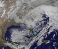
GFS is beginning to show hints of storm signals in the LR, buckle up buddies.
NjWeatherGuy- Advanced Forecaster

- Posts : 4100
Reputation : 28
Join date : 2013-01-06
Location : Belle Mead, NJ
 Re: Long Range Thread 9.0
nutleyblizzard wrote:With today's encouraging developments I wonder if Frank is ready to commit on a date for a pattern change.
The next 10-14 days could dictate how the entire winter plays out. I know it sounds silly, but the Stratosphere better start making positive strides. The PV split at 50mb is temporary from the anomalous Scandinavian ridge. Once that ridge breaks down, the PV reconsolidates over the North Pole. Luckily, I'm still feeling optimistic about the Strat after reading Cohens blog. I'll issue an official pattern change date once my confidence level reaches 80% with the Stratosphere. Right now it's around 60%
algae888 wrote:Oh-no I just read this from a met from another board...
"Here's the problem with your MJO argument. In ENSO filtered MJO events (those years where we have Jan ENSO 3.4 anomalies >1 degree above normal) both phase 8 and phase 1 are both positively correlated to above normal temps in the northeast. So, if you're arguing more of a phase 8 look to it, you're actually arguing for more warmth in the northeast. That's actually reflected pretty well in the Euro ENS today, which had a +3 to +5 anomaly painted over the northeast as a mean for the 11-15 day period.
Worse yet, the phase 1 composites argue even more mild weather nationally, particularly across the northern tier.
We're certainly not going to be able to sustain +30 degree warmth, but whether we're even able to get back to seasonable conditions for longer than a 1-2 day stretch in Jan is absolutely up for debate."
Is this true? I've never heard any other met or knowledgeable person about the weather say this. My next question if this is true is there any phase of the mjo that would favor colder than normal temperatures in the Northeast for January with enso 3.4 >1?
He has a point. That said, the MJO going into the aforementioned phases will actually help with the wavebreaking into the Stratosphere. I can care less about our sensible weather now. I care more about mid to late January and beyond.
algae888 wrote:He basically goes on to say that the only way we're going to get sustained cold and below normal temperatures here in the Northeast with such a strong El Nino is to get some kind of blocking. He did not reference anyone in particular whether it's the EPO AO or NAO.
http://www.meteonetwork.it/models/mjo/ is a good place to start. That's freely available. This is the link to the site he used for his data
Atlantic blocking may not happen at all this year. If it does, won't be until mid February.
NjWeatherGuy wrote:GFS is beginning to show hints of storm signals in the LR, buckle up buddies.
Don't get your hopes up.
_________________
_______________________________________________________________________________________________________
CLICK HERE to view NJ Strong Snowstorm Classifications
 Re: Long Range Thread 9.0
Today's ensembles continue showing January to feature an upper air pattern vastly different from what we've seen in December. There is much more ridging taking place in western NA.
EPS valid Jan 1:

GEFS valid Jan 1:

The Scandinavian ridge begins to expand at this time N&E which should continue raiding the lower Stratosphere with above normal temps. Positive heights are seen across Canada and the western US. With the MJO remaining active and amplifying into phases 6-7, this should maintain ridging in those regions. The east will at least be seasonable if not slightly below normal.
EPS valid Jan 5th:

GEFS valid Jan 5th:


The aforementioned atmospheric anomalies look even more impressive / stronger by the end of the first week of January. Tropical forcing and +AAM looks to persist which should keep the pattern amplified, as opposed to progressive. The amplified pattern (signaled by troughs and ridges) should keep the wavebreaking into the Stratosphere alive. Cohens model predicts +WAF to pick back up come early January. This is a critical time. Hopefully we begin seeing the displacement / split response we want from the Strat PV. As long as these forecasts come to fruition I continue to remain on the optimistic side.
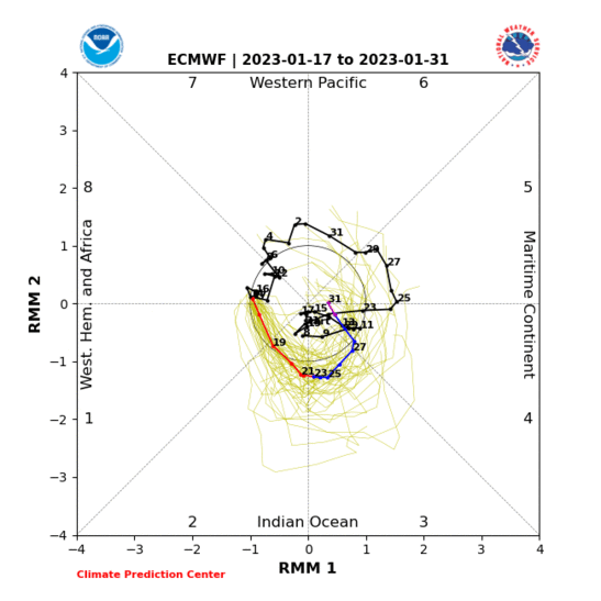
Yesterday the EURO did not even show the MJO entering phase 7. It was crashing it into the COD. Completely different look today, which is why I think the EPS (and GEFS) are showing an amplified 500mb pattern down the road.
EPS valid Jan 1:

GEFS valid Jan 1:

The Scandinavian ridge begins to expand at this time N&E which should continue raiding the lower Stratosphere with above normal temps. Positive heights are seen across Canada and the western US. With the MJO remaining active and amplifying into phases 6-7, this should maintain ridging in those regions. The east will at least be seasonable if not slightly below normal.
EPS valid Jan 5th:

GEFS valid Jan 5th:


The aforementioned atmospheric anomalies look even more impressive / stronger by the end of the first week of January. Tropical forcing and +AAM looks to persist which should keep the pattern amplified, as opposed to progressive. The amplified pattern (signaled by troughs and ridges) should keep the wavebreaking into the Stratosphere alive. Cohens model predicts +WAF to pick back up come early January. This is a critical time. Hopefully we begin seeing the displacement / split response we want from the Strat PV. As long as these forecasts come to fruition I continue to remain on the optimistic side.

Yesterday the EURO did not even show the MJO entering phase 7. It was crashing it into the COD. Completely different look today, which is why I think the EPS (and GEFS) are showing an amplified 500mb pattern down the road.
_________________
_______________________________________________________________________________________________________
CLICK HERE to view NJ Strong Snowstorm Classifications
 Re: Long Range Thread 9.0
Frank great positive and very encouraging write up. Step down evolution process taking shape. Everything right on track for the mid Jan turn at our level. It us already turning way above our heads.
_________________
Mugs
AKA:King: Snow Weenie
Self Proclaimed
WINTER 2014-15 : 55.12" +.02 for 6 coatings (avg. 35")
WINTER 2015-16 Total - 29.8" (Avg 35")
WINTER 2016-17 : 39.5" so far

amugs- Advanced Forecaster - Mod

- Posts : 15130
Reputation : 213
Join date : 2013-01-07
Age : 54
Location : Hillsdale,NJ
 Re: Long Range Thread 9.0
Deleted by owner
Last edited by CPcantmeasuresnow on Wed Dec 23, 2015 9:57 am; edited 1 time in total

CPcantmeasuresnow- Wx Statistician Guru

- Posts : 7274
Reputation : 230
Join date : 2013-01-07
Age : 103
Location : Eastern Orange County, NY
 Re: Long Range Thread 9.0
with regard to mjo and 3.4>1 for phase 8 and 1 being warm for us well last night I found out it only happened 3 times so sample size is small. also steve d addressed this issue this morning since it was all over twitter. here is part of his disco...
"You see, in the MJO years that were taken in which the MJO was a strong positive, in other words strong, each one of those El Nino phases were east based, in other words the strongest anomalies were not in 3.4 but in 1.2 and 3. The years takes where 1998, 1993, and 1983. All three of those years were east based El Nino phases which strongly supports the Sub Tropical jet stream remaining the dominant feature, flooding the United States with mild air and never centering the core of the convection around the date line. The phase 8 of the MJO was basically muted out and became a none factor. In all of those cases, snow growth in Siberia was below normal which means there was also no mechanism to disrupt the strong Polar Vortex that had developed. In this year, none of those factors are true."
I say bring on phase 8 and 1 and lets see how it plays out.

algae888- Advanced Forecaster

- Posts : 5311
Reputation : 46
Join date : 2013-02-05
Age : 62
Location : mt. vernon, new york
 Re: Long Range Thread 9.0
Dave's comments after the new NOAA map came out predicting a warmer winter for us....
"We're not going to be getting into patterns later this winter where we lock in cold air for weeks on end," said New Jersey state climatologist Dave Robinson. "It's not to say that we're not going to have some cold weeks. It's not to say that we're going to see some flakes flying at some points."
_________________
Janet
Snowfall winter of 2023-2024 17.5"
Snowfall winter of 2022-2023 6.0"
Snowfall winter of 2021-2022 17.6" 1" sleet 2/25/22
Snowfall winter of 2020-2021 51.1"
Snowfall winter of 2019-2020 8.5"
Snowfall winter of 2018-2019 25.1"
Snowfall winter of 2017-2018 51.9"
Snowfall winter of 2016-2017 45.6"
Snowfall winter of 2015-2016 29.5"
Snowfall winter of 2014-2015 50.55"
Snowfall winter of 2013-2014 66.5"
Dunnzoo- Senior Enthusiast - Mod

- Posts : 4922
Reputation : 68
Join date : 2013-01-11
Age : 62
Location : Westwood, NJ
 Re: Long Range Thread 9.0
Frank you know I am not an overly optimistic person by any means. That being said what I meant was we're seeing signals of the pattern change beginning to show up strongly in the LR on the models and with that will inevitably come storm chances and things to track. Things will look up from this dismal December pattern and when your at the bottom theres nowhere to go but up.

NjWeatherGuy- Advanced Forecaster

- Posts : 4100
Reputation : 28
Join date : 2013-01-06
Location : Belle Mead, NJ
 Re: Long Range Thread 9.0
NjWeatherGuy wrote:Frank you know I am not an overly optimistic person by any means. That being said what I meant was we're seeing signals of the pattern change beginning to show up strongly in the LR on the models and with that will inevitably come storm chances and things to track. Things will look up from this dismal December pattern and when your at the bottom theres nowhere to go but up.
Well said.
_________________
"In weather and in life, there's no winning and losing; there's only winning and learning."
WINTER 2012/2013 TOTALS 43.65"WINTER 2017/2018 TOTALS 62.85" WINTER 2022/2023 TOTALS 4.9"
WINTER 2013/2014 TOTALS 64.85"WINTER 2018/2019 TOTALS 14.25" WINTER 2023/2024 TOTALS 13.1"
WINTER 2014/2015 TOTALS 71.20"WINTER 2019/2020 TOTALS 6.35"
WINTER 2015/2016 TOTALS 35.00"WINTER 2020/2021 TOTALS 37.75"
WINTER 2016/2017 TOTALS 42.25"WINTER 2021/2022 TOTALS 31.65"

sroc4- Admin

- Posts : 8442
Reputation : 302
Join date : 2013-01-07
Location : Wading River, LI
 Re: Long Range Thread 9.0
algae888 wrote:with regard to mjo and 3.4>1 for phase 8 and 1 being warm for us well last night I found out it only happened 3 times so sample size is small. also steve d addressed this issue this morning since it was all over twitter. here is part of his disco...
"You see, in the MJO years that were taken in which the MJO was a strong positive, in other words strong, each one of those El Nino phases were east based, in other words the strongest anomalies were not in 3.4 but in 1.2 and 3. The years takes where 1998, 1993, and 1983. All three of those years were east based El Nino phases which strongly supports the Sub Tropical jet stream remaining the dominant feature, flooding the United States with mild air and never centering the core of the convection around the date line. The phase 8 of the MJO was basically muted out and became a none factor. In all of those cases, snow growth in Siberia was below normal which means there was also no mechanism to disrupt the strong Polar Vortex that had developed. In this year, none of those factors are true."
I say bring on phase 8 and 1 and lets see how it plays out.
Al when you reference the years do you mean 1993 as in the winter of 1993/94? That is still one of the coldest and snowiest in my lifetime. The other two pathetic. Why the huge divergence?

CPcantmeasuresnow- Wx Statistician Guru

- Posts : 7274
Reputation : 230
Join date : 2013-01-07
Age : 103
Location : Eastern Orange County, NY
 Re: Long Range Thread 9.0
Cp all those dates are for January of that year so that would be 92/93 . I'm on my cell and can't post the anomaly map but it's all over Twitter. What's interesting is that only three strong El Nino winters produced an mjo in phase 8 or 1 so that's only a small sample size and don't forget February of 83 produced a big snowstorm for New York City I think we received 18 inches around February 18th or 20thCPcantmeasuresnow wrote:algae888 wrote:with regard to mjo and 3.4>1 for phase 8 and 1 being warm for us well last night I found out it only happened 3 times so sample size is small. also steve d addressed this issue this morning since it was all over twitter. here is part of his disco...
"You see, in the MJO years that were taken in which the MJO was a strong positive, in other words strong, each one of those El Nino phases were east based, in other words the strongest anomalies were not in 3.4 but in 1.2 and 3. The years takes where 1998, 1993, and 1983. All three of those years were east based El Nino phases which strongly supports the Sub Tropical jet stream remaining the dominant feature, flooding the United States with mild air and never centering the core of the convection around the date line. The phase 8 of the MJO was basically muted out and became a none factor. In all of those cases, snow growth in Siberia was below normal which means there was also no mechanism to disrupt the strong Polar Vortex that had developed. In this year, none of those factors are true."
I say bring on phase 8 and 1 and lets see how it plays out.
Al when you reference the years do you mean 1993 as in the winter of 1993/94? That is still one of the coldest and snowiest in my lifetime. The other two pathetic. Why the huge divergence?

algae888- Advanced Forecaster

- Posts : 5311
Reputation : 46
Join date : 2013-02-05
Age : 62
Location : mt. vernon, new york
 Re: Long Range Thread 9.0
Cp the February 83 snow storm was not in 8 or 1. it moved into a different phase not sure which one in early February.

algae888- Advanced Forecaster

- Posts : 5311
Reputation : 46
Join date : 2013-02-05
Age : 62
Location : mt. vernon, new york
 Re: Long Range Thread 9.0
We have to watch the system on the 28th and 29th of December for some sort of frozen precipitation here. The high pressure sitting over maine keeps getting stronger with each run. as you know it's hard to push these high pressures out late December. 850 s are forecast to be -5 to -10 Celsius on Monday the 28th as far south as New York City the NAO will be dropping to neutral at this time 2sd from where it was so I think we have something to watch. at least for seeing some kind of wintry weather and definitely favors the interior.

algae888- Advanced Forecaster

- Posts : 5311
Reputation : 46
Join date : 2013-02-05
Age : 62
Location : mt. vernon, new york
 Re: Long Range Thread 9.0
^If precipitation manages to break out along the cold sector of the front (which it shows it struggling to with plenty of moisture south) it could be something to watch but i wouldnt get my hopes up. More interested in the January timeframe when things really start changing.

NjWeatherGuy- Advanced Forecaster

- Posts : 4100
Reputation : 28
Join date : 2013-01-06
Location : Belle Mead, NJ
 Re: Long Range Thread 9.0
Today's 12z GFS is trending colder for the Monday Tuesday storm it now has the northern third of New Jersey receiving some sort of frozen precip. The high pressure at hour 138 sits in Southeast Canada west of yesterday's runs so as the Warm Front approaches because of the storm cutting our wind flow should be from the north and northeast locking in the cold air for a while. It's a 1040mb high pressure very strong with plenty of cold air available looks rather interesting especially for the northwest suburbs
Last edited by algae888 on Wed Dec 23, 2015 11:31 am; edited 1 time in total

algae888- Advanced Forecaster

- Posts : 5311
Reputation : 46
Join date : 2013-02-05
Age : 62
Location : mt. vernon, new york
 Re: Long Range Thread 9.0
algae888 wrote:Cp the February 83 snow storm was not in 8 or 1. it moved into a different phase not sure which one in early February.
Here is the MJO for Jan-March 83' Looks like we were in a week phase 5-6 during Feb 18-20 that year.

_________________
"In weather and in life, there's no winning and losing; there's only winning and learning."
WINTER 2012/2013 TOTALS 43.65"WINTER 2017/2018 TOTALS 62.85" WINTER 2022/2023 TOTALS 4.9"
WINTER 2013/2014 TOTALS 64.85"WINTER 2018/2019 TOTALS 14.25" WINTER 2023/2024 TOTALS 13.1"
WINTER 2014/2015 TOTALS 71.20"WINTER 2019/2020 TOTALS 6.35"
WINTER 2015/2016 TOTALS 35.00"WINTER 2020/2021 TOTALS 37.75"
WINTER 2016/2017 TOTALS 42.25"WINTER 2021/2022 TOTALS 31.65"

sroc4- Admin

- Posts : 8442
Reputation : 302
Join date : 2013-01-07
Location : Wading River, LI
 Re: Long Range Thread 9.0
The storm cuts and transfer to a coastal low south of Long Island off the Jersey coast it pummels southern New England and our friends in Boston will have big smiles on their faces. Also snowman CP doc Will have a significant ice storm if this were to verify. Imagine going from the 70's tomorrow and the sixties on Sunday to a snow and ice storm on Tuesday

algae888- Advanced Forecaster

- Posts : 5311
Reputation : 46
Join date : 2013-02-05
Age : 62
Location : mt. vernon, new york
 Re: Long Range Thread 9.0
Frank and Scott an Rb look at what the GFS does with that high pressure system it just continues Building it in. its not budging. So the low pressure that cuts has no choice but to redevelop off the coast. what do you guys think

algae888- Advanced Forecaster

- Posts : 5311
Reputation : 46
Join date : 2013-02-05
Age : 62
Location : mt. vernon, new york
Page 27 of 40 •  1 ... 15 ... 26, 27, 28 ... 33 ... 40
Page 27 of 40
Permissions in this forum:
You cannot reply to topics in this forum|
|
|

 Home
Home