
 Search
Long Range Thread 9.0
Page 26 of 40 •  1 ... 14 ... 25, 26, 27 ... 33 ... 40
 ![]()
Re: Long Range Thread 9.0
![]() by HectorO Mon Dec 21, 2015 8:57 pm
by HectorO Mon Dec 21, 2015 8:57 pm
HectorO- Pro Enthusiast

- Posts : 959
Join date : 2013-01-11
Re: Long Range Thread 9.0
![]() by Frank_Wx Mon Dec 21, 2015 9:16 pm
by Frank_Wx Mon Dec 21, 2015 9:16 pm
Frank_Wx- Godzilla Seeker

- Posts : 21305
Join date : 2013-01-05 -

Re: Long Range Thread 9.0
![]() by Snow88 Tue Dec 22, 2015 12:00 am
by Snow88 Tue Dec 22, 2015 12:00 am

Snow88- Senior Enthusiast

- Posts : 2193
Reputation : 4
Join date : 2013-01-09
Age : 35
Location : Brooklyn, NY
Re: Long Range Thread 9.0
![]() by Abba701 Tue Dec 22, 2015 12:05 am
by Abba701 Tue Dec 22, 2015 12:05 am
Abba701- Posts : 328
Reputation : 0
Join date : 2013-01-14
Re: Long Range Thread 9.0
![]() by CPcantmeasuresnow Tue Dec 22, 2015 12:29 am
by CPcantmeasuresnow Tue Dec 22, 2015 12:29 am
HectorO wrote:Imagine if this continues through March. We'll be so acclimated to warm weather that if we get hammered next winter, we're going to freeze to death. This week will be the warmest winter I've been in since I left Florida 10 years ago.
Well the warmest December by far in 147 years of record keeping will do that. I've lived in this area for over 50 years and have never seen a December anything like this. Preceded by a pretty crappy November I might add.

CPcantmeasuresnow- Wx Statistician Guru

- Posts : 7274
Reputation : 230
Join date : 2013-01-07
Age : 103
Location : Eastern Orange County, NY
Re: Long Range Thread 9.0
![]() by Abba701 Tue Dec 22, 2015 12:37 am
by Abba701 Tue Dec 22, 2015 12:37 am
Abba701- Posts : 328
Reputation : 0
Join date : 2013-01-14
Re: Long Range Thread 9.0
![]() by docstox12 Tue Dec 22, 2015 12:55 am
by docstox12 Tue Dec 22, 2015 12:55 am
Abba701 wrote:Something tells me there will be a payback at some point in the next few months.But I could be wrong.
I've got that too, Abba.This November and December have coiled the spring to a level unseen before and something has to give.Hoping it does in February and March and NOT in April and May with cold and rain.UGH!!!

docstox12- Wx Statistician Guru
- Posts : 8506
Reputation : 222
Join date : 2013-01-07
Age : 73
Location : Monroe NY
Re: Long Range Thread 9.0
![]() by Abba701 Tue Dec 22, 2015 1:00 am
by Abba701 Tue Dec 22, 2015 1:00 am
Abba701- Posts : 328
Reputation : 0
Join date : 2013-01-14
Re: Long Range Thread 9.0
![]() by docstox12 Tue Dec 22, 2015 1:16 am
by docstox12 Tue Dec 22, 2015 1:16 am
docstox12- Wx Statistician Guru
- Posts : 8506
Reputation : 222
Join date : 2013-01-07
Age : 73
Location : Monroe NY
Re: Long Range Thread 9.0
![]() by NjWeatherGuy Tue Dec 22, 2015 3:12 am
by NjWeatherGuy Tue Dec 22, 2015 3:12 am
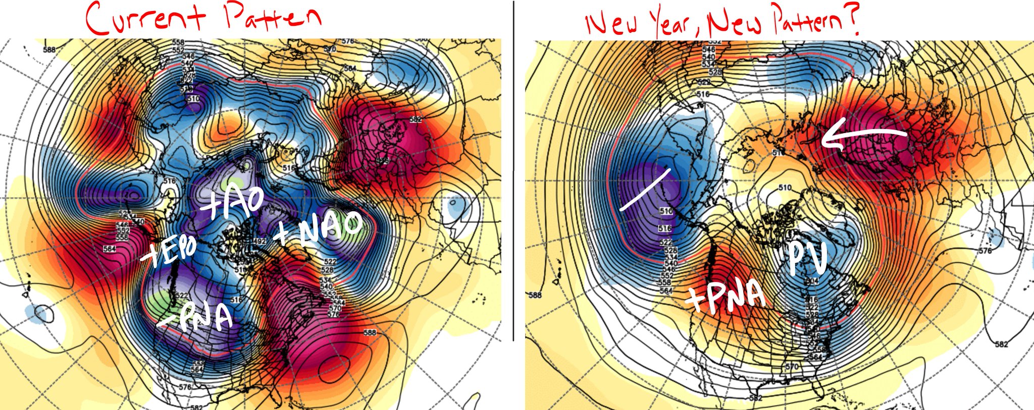
Not really a ridge, progressive PAC flow that keeps the whole country mild. I think these signals are pointing to the pattern slowly changing. No amped SE ridge and trough in the west anymore. Instead transient troughiness in the east followed by progressive mild but not warm flow, alternating cycles. Eventually the PV will settle over eastern Canada hopefully and push the arctic air into the eastern US for good. NAO looking to go neutral.Snow88 wrote:0z GFS brings in the cold around Jan 1 but only for a few days before a ridge comes back. It looks nothing like the ensembles. It's also in weenie land so take anything that far with a grain of salt.

NjWeatherGuy- Advanced Forecaster

- Posts : 4100
Reputation : 28
Join date : 2013-01-06
Location : Belle Mead, NJ
Re: Long Range Thread 9.0
![]() by sroc4 Tue Dec 22, 2015 6:46 am
by sroc4 Tue Dec 22, 2015 6:46 am
NjWeatherGuy wrote:Not really a ridge, progressive PAC flow that keeps the whole country mild. I think these signals are pointing to the pattern slowly changing. No amped SE ridge and trough in the west anymore. Instead transient troughiness in the east followed by progressive mild but not warm flow, alternating cycles. Eventually the PV will settle over eastern Canada hopefully and push the arctic air into the eastern US for good. NAO looking to go neutral.Snow88 wrote:0z GFS brings in the cold around Jan 1 but only for a few days before a ridge comes back. It looks nothing like the ensembles. It's also in weenie land so take anything that far with a grain of salt.
Interpreting a single GFS run in the 300hr range esp during a transition, is like interpreting how a starting picture will perform in the post season in April. European and GFS ensembles are showing a strong signal for a positive pna and negative EPO. Step one.
_________________
"In weather and in life, there's no winning and losing; there's only winning and learning."
WINTER 2012/2013 TOTALS 43.65"WINTER 2017/2018 TOTALS 62.85" WINTER 2022/2023 TOTALS 4.9"
WINTER 2013/2014 TOTALS 64.85"WINTER 2018/2019 TOTALS 14.25" WINTER 2023/2024 TOTALS 13.1"
WINTER 2014/2015 TOTALS 71.20"WINTER 2019/2020 TOTALS 6.35"
WINTER 2015/2016 TOTALS 35.00"WINTER 2020/2021 TOTALS 37.75"
WINTER 2016/2017 TOTALS 42.25"WINTER 2021/2022 TOTALS 31.65"

sroc4- Admin
- Posts : 8331
Reputation : 301
Join date : 2013-01-07
Location : Wading River, LI
Re: Long Range Thread 9.0
![]() by algae888 Tue Dec 22, 2015 8:45 am
by algae888 Tue Dec 22, 2015 8:45 am
yes scott and the pna signal is only getting stronger each day..sroc4 wrote:NjWeatherGuy wrote:Not really a ridge, progressive PAC flow that keeps the whole country mild. I think these signals are pointing to the pattern slowly changing. No amped SE ridge and trough in the west anymore. Instead transient troughiness in the east followed by progressive mild but not warm flow, alternating cycles. Eventually the PV will settle over eastern Canada hopefully and push the arctic air into the eastern US for good. NAO looking to go neutral.Snow88 wrote:0z GFS brings in the cold around Jan 1 but only for a few days before a ridge comes back. It looks nothing like the ensembles. It's also in weenie land so take anything that far with a grain of salt.
Interpreting a single GFS run in the 300hr range esp during a transition, is like interpreting how a starting picture will perform in the post season in April. European and GFS ensembles are showing a strong signal for a positive pna and negative EPO. Step one.
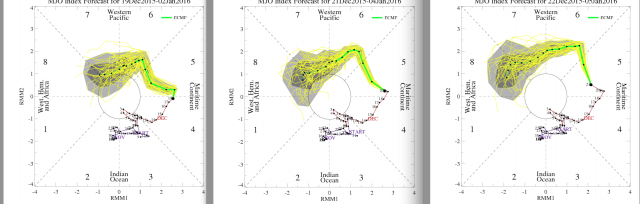
step 3...mjo which is probably why we get the +pna/-epo...
this signal is also getting stronger esp the gfs coming in line with the euro. notice how the indian ocean convection has died down.next up the strat

algae888- Advanced Forecaster
- Posts : 5311
Reputation : 46
Join date : 2013-02-05
Age : 61
Location : mt. vernon, new york
Re: Long Range Thread 9.0
![]() by algae888 Tue Dec 22, 2015 11:03 am
by algae888 Tue Dec 22, 2015 11:03 am
algae888- Advanced Forecaster
- Posts : 5311
Reputation : 46
Join date : 2013-02-05
Age : 61
Location : mt. vernon, new york
Re: Long Range Thread 9.0
![]() by algae888 Tue Dec 22, 2015 11:06 am
by algae888 Tue Dec 22, 2015 11:06 am
algae888- Advanced Forecaster
- Posts : 5311
Reputation : 46
Join date : 2013-02-05
Age : 61
Location : mt. vernon, new york
Re: Long Range Thread 9.0
![]() by algae888 Tue Dec 22, 2015 11:12 am
by algae888 Tue Dec 22, 2015 11:12 am
algae888- Advanced Forecaster
- Posts : 5311
Reputation : 46
Join date : 2013-02-05
Age : 61
Location : mt. vernon, new york
Re: Long Range Thread 9.0
![]() by rb924119 Tue Dec 22, 2015 11:49 am
by rb924119 Tue Dec 22, 2015 11:49 am
rb924119- Meteorologist

- Posts : 6890
Reputation : 194
Join date : 2013-02-06
Age : 32
Location : Greentown, Pa
Re: Long Range Thread 9.0
![]() by algae888 Tue Dec 22, 2015 12:13 pm
by algae888 Tue Dec 22, 2015 12:13 pm
algae888- Advanced Forecaster
- Posts : 5311
Reputation : 46
Join date : 2013-02-05
Age : 61
Location : mt. vernon, new york
Re: Long Range Thread 9.0
![]() by skinsfan1177 Tue Dec 22, 2015 12:23 pm
by skinsfan1177 Tue Dec 22, 2015 12:23 pm

skinsfan1177- Senior Enthusiast
- Posts : 4485
Reputation : 35
Join date : 2013-01-07
Age : 46
Location : Point Pleasant Boro
Re: Long Range Thread 9.0
![]() by algae888 Tue Dec 22, 2015 12:26 pm
by algae888 Tue Dec 22, 2015 12:26 pm
algae888- Advanced Forecaster
- Posts : 5311
Reputation : 46
Join date : 2013-02-05
Age : 61
Location : mt. vernon, new york
Re: Long Range Thread 9.0
![]() by algae888 Tue Dec 22, 2015 12:32 pm
by algae888 Tue Dec 22, 2015 12:32 pm
Skins as of today the pattern is already starting to change and we should feel its effects starting next week with a return to more normal temperatures and storms that will less likely cut. In regards to the NAO we don't necessarily need it to be negative. We just need it to fluctuate back and forth from positive to negative and so on. I've read where data shows when this occurs storms often form near our areaskinsfan1177 wrote:So is their any signs as we speak now that show when the pattern flips it may eventually get locked in. What do we need for it to the AO to go negative I know past couple winters NAO has been meaning less
algae888- Advanced Forecaster
- Posts : 5311
Reputation : 46
Join date : 2013-02-05
Age : 61
Location : mt. vernon, new york
Re: Long Range Thread 9.0
![]() by amugs Tue Dec 22, 2015 1:07 pm
by amugs Tue Dec 22, 2015 1:07 pm
Look at this:

From the Bell at the models playing catch up - no denying it peeps the changes are coming - get out the hot flash meds for some will be needing it as we get into JAN - ooofffffaaaaaaaaaa!!
_________________
Mugs
AKA:King: Snow Weenie
Self Proclaimed
WINTER 2014-15 : 55.12" +.02 for 6 coatings (avg. 35")
WINTER 2015-16 Total - 29.8" (Avg 35")
WINTER 2016-17 : 39.5" so far

amugs- Advanced Forecaster - Mod

- Posts : 15093
Reputation : 213
Join date : 2013-01-07
Age : 54
Location : Hillsdale,NJ
Re: Long Range Thread 9.0
![]() by nutleyblizzard Tue Dec 22, 2015 1:13 pm
by nutleyblizzard Tue Dec 22, 2015 1:13 pm

nutleyblizzard- Senior Enthusiast
- Posts : 1952
Reputation : 41
Join date : 2014-01-30
Age : 58
Location : Nutley, new jersey
Re: Long Range Thread 9.0
![]() by skinsfan1177 Tue Dec 22, 2015 1:21 pm
by skinsfan1177 Tue Dec 22, 2015 1:21 pm
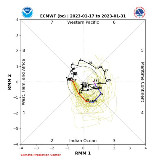
amugs wrote:Well well - the models playing catch up to the pertubation in the atmosphere - the startosphere is seeing a ssw amongst, waves are getting shorter and going into winter mode. The MJO saying we go into phase 7 and then into 8 and Earthlight and Isotherm saying the changes are already happening over our heads but have not made to us YET!
Look at this:
From the Bell at the models playing catch up - no denying it peeps the changes are coming - get out the hot flash meds for some will be needing it as we get into JAN - ooofffffaaaaaaaaaa!!
Is it for certain it goes into phase 8 or can it crash after 7
skinsfan1177- Senior Enthusiast
- Posts : 4485
Reputation : 35
Join date : 2013-01-07
Age : 46
Location : Point Pleasant Boro
Re: Long Range Thread 9.0
![]() by amugs Tue Dec 22, 2015 1:33 pm
by amugs Tue Dec 22, 2015 1:33 pm
_________________
Mugs
AKA:King: Snow Weenie
Self Proclaimed
WINTER 2014-15 : 55.12" +.02 for 6 coatings (avg. 35")
WINTER 2015-16 Total - 29.8" (Avg 35")
WINTER 2016-17 : 39.5" so far
amugs- Advanced Forecaster - Mod
- Posts : 15093
Reputation : 213
Join date : 2013-01-07
Age : 54
Location : Hillsdale,NJ
Re: Long Range Thread 9.0
![]() by algae888 Tue Dec 22, 2015 2:54 pm
by algae888 Tue Dec 22, 2015 2:54 pm
"Here's the problem with your MJO argument. In ENSO filtered MJO events (those years where we have Jan ENSO 3.4 anomalies >1 degree above normal) both phase 8 and phase 1 are both positively correlated to above normal temps in the northeast. So, if you're arguing more of a phase 8 look to it, you're actually arguing for more warmth in the northeast. That's actually reflected pretty well in the Euro ENS today, which had a +3 to +5 anomaly painted over the northeast as a mean for the 11-15 day period.
Worse yet, the phase 1 composites argue even more mild weather nationally, particularly across the northern tier.
We're certainly not going to be able to sustain +30 degree warmth, but whether we're even able to get back to seasonable conditions for longer than a 1-2 day stretch in Jan is absolutely up for debate."
Is this true? I've never heard any other met or knowledgeable person about the weather say this. My next question if this is true is there any phase of the mjo that would favor colder than normal temperatures in the Northeast for January with enso 3.4 >1?
algae888- Advanced Forecaster
- Posts : 5311
Reputation : 46
Join date : 2013-02-05
Age : 61
Location : mt. vernon, new york
Re: Long Range Thread 9.0
![]() by algae888 Tue Dec 22, 2015 3:08 pm
by algae888 Tue Dec 22, 2015 3:08 pm
http://www.meteonetwork.it/models/mjo/ is a good place to start. That's freely available. This is the link to the site he used for his data
algae888- Advanced Forecaster
- Posts : 5311
Reputation : 46
Join date : 2013-02-05
Age : 61
Location : mt. vernon, new york
Re: Long Range Thread 9.0
![]() by skinsfan1177 Tue Dec 22, 2015 3:16 pm
by skinsfan1177 Tue Dec 22, 2015 3:16 pm
skinsfan1177- Senior Enthusiast
- Posts : 4485
Reputation : 35
Join date : 2013-01-07
Age : 46
Location : Point Pleasant Boro
Page 26 of 40 • 1 ... 14 ... 25, 26, 27 ... 33 ... 40 ![]()
|
|
|