
 Search
Long Range Thread 10.0
Page 19 of 28 •  1 ... 11 ... 18, 19, 20 ... 23 ... 28
 ![]()
Re: Long Range Thread 10.0
![]() by amugs Wed Feb 17, 2016 3:07 pm
by amugs Wed Feb 17, 2016 3:07 pm
6-10 DAYS
.png)
PARA SAYS SO
.png)
11-15 DAYS - HOLY MAP !!
.png)
amugs- Advanced Forecaster - Mod

- Posts : 15093
Join date : 2013-01-07
Re: Long Range Thread 10.0
![]() by sroc4 Wed Feb 17, 2016 3:08 pm
by sroc4 Wed Feb 17, 2016 3:08 pm
jmanley32 wrote:GFS and CMC inland traqcks, Euro on its own. Doesn't seem to look gr8, am I wrong? I remember some people saying the Euro has been aweful this season.?
Dont be surprised to see waffling with all the models over the next few days
sroc4- Admin

- Posts : 8331
Join date : 2013-01-07
Re: Long Range Thread 10.0
![]() by amugs Wed Feb 17, 2016 3:12 pm
by amugs Wed Feb 17, 2016 3:12 pm
jmanley32 wrote:GFS and CMC inland traqcks, Euro on its own. Doesn't seem to look gr8, am I wrong? I remember some people saying the Euro has been aweful this season.?
WHAT??? WE HAVE 100 -120 HOURS UNTIL WE NAIL THIS DOWN. THE HANDLING OF THE PV LOCATION IS BIG HERE AS IS THE PHASE. THE CMC AND GFS SAY THE WAR - WESTERN ATLANTIC RIDGE - PRESSES ON US - EURO SAYS NO GET OUT OF HERE WITH THAT WAR AND IT DOES SO WITH A SYSTEM ON MONDAY.
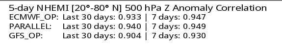
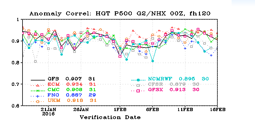
EURO AND PARA ARE 1&2 FOR US THIS WINTER IN VERIFICATION SCORES FROM WHAT I HAVE READ AND YES IT BLEW SOME STORMS. AND HAD A BAD STRETCH BUT HOPEFULLY IT IS COMING BACK.
WE SHALL SEE.
_________________
Mugs
AKA:King: Snow Weenie
Self Proclaimed
WINTER 2014-15 : 55.12" +.02 for 6 coatings (avg. 35")
WINTER 2015-16 Total - 29.8" (Avg 35")
WINTER 2016-17 : 39.5" so far

amugs- Advanced Forecaster - Mod
- Posts : 15093
Reputation : 213
Join date : 2013-01-07
Age : 54
Location : Hillsdale,NJ
Re: Long Range Thread 10.0
![]() by amugs Wed Feb 17, 2016 3:15 pm
by amugs Wed Feb 17, 2016 3:15 pm
_________________
Mugs
AKA:King: Snow Weenie
Self Proclaimed
WINTER 2014-15 : 55.12" +.02 for 6 coatings (avg. 35")
WINTER 2015-16 Total - 29.8" (Avg 35")
WINTER 2016-17 : 39.5" so far
amugs- Advanced Forecaster - Mod
- Posts : 15093
Reputation : 213
Join date : 2013-01-07
Age : 54
Location : Hillsdale,NJ
Re: Long Range Thread 10.0
![]() by jmanley32 Wed Feb 17, 2016 3:25 pm
by jmanley32 Wed Feb 17, 2016 3:25 pm
sroc4 wrote:jmanley32 wrote:GFS and CMC inland traqcks, Euro on its own. Doesn't seem to look gr8, am I wrong? I remember some people saying the Euro has been aweful this season.?
Dont be surprised to see waffling with all the models over the next few days
Yeah sorry just been in a bad mood was hoping see some fun model runs, work been murder.

jmanley32- Senior Enthusiast

- Posts : 20517
Reputation : 108
Join date : 2013-12-12
Age : 42
Location : Yonkers, NY
Re: Long Range Thread 10.0
![]() by jmanley32 Wed Feb 17, 2016 3:26 pm
by jmanley32 Wed Feb 17, 2016 3:26 pm
amugs wrote:jmanley32 wrote:GFS and CMC inland traqcks, Euro on its own. Doesn't seem to look gr8, am I wrong? I remember some people saying the Euro has been aweful this season.?
WHAT??? WE HAVE 100 -120 HOURS UNTIL WE NAIL THIS DOWN. THE HANDLING OF THE PV LOCATION IS BIG HERE AS IS THE PHASE. THE CMC AND GFS SAY THE WAR - WESTERN ATLANTIC RIDGE - PRESSES ON US - EURO SAYS NO GET OUT OF HERE WITH THAT WAR AND IT DOES SO WITH A SYSTEM ON MONDAY.
EURO AND PARA ARE 1&2 FOR US THIS WINTER IN VERIFICATION SCORES FROM WHAT I HAVE READ AND YES IT BLEW SOME STORMS. AND HAD A BAD STRETCH BUT HOPEFULLY IT IS COMING BACK.
WE SHALL SEE.
ahh mugs your persistent optimism helps us along : )
jmanley32- Senior Enthusiast
- Posts : 20517
Reputation : 108
Join date : 2013-12-12
Age : 42
Location : Yonkers, NY
Re: Long Range Thread 10.0
![]() by New Yorker 234 Wed Feb 17, 2016 3:26 pm
by New Yorker 234 Wed Feb 17, 2016 3:26 pm
Thanks.
New Yorker 234- Posts : 32
Reputation : 0
Join date : 2013-10-01
Location : Midtown East, Manhattan
Re: Long Range Thread 10.0
![]() by jmanley32 Wed Feb 17, 2016 3:27 pm
by jmanley32 Wed Feb 17, 2016 3:27 pm
jmanley32- Senior Enthusiast
- Posts : 20517
Reputation : 108
Join date : 2013-12-12
Age : 42
Location : Yonkers, NY
Re: Long Range Thread 10.0
![]() by jmanley32 Wed Feb 17, 2016 3:28 pm
by jmanley32 Wed Feb 17, 2016 3:28 pm
New Yorker 234 wrote:I am due to fly back into LGA Monday afternoon the 22nd. Any indication that the weather that afternoon will be such that I should try to change to a morning flight or even a Sunday night before flight?
Thanks.
As mugs reminded me we have neaqrly 5 days still to go so IMO to make travel plan changes not yet.
jmanley32- Senior Enthusiast
- Posts : 20517
Reputation : 108
Join date : 2013-12-12
Age : 42
Location : Yonkers, NY
Re: Long Range Thread 10.0
![]() by Dtone Wed Feb 17, 2016 3:45 pm
by Dtone Wed Feb 17, 2016 3:45 pm
jmanley32 wrote:BTW sorry this is noit LR but how do I find out what my average snowfall should be? am I close enough to NYC to go by that, but then again more times than not I see more snow than NYC, aside from Jonas.
NWS will use the closest climate station, which is most likely LGA for you. Its close between LGA and Teterboro for closest reporting station (depends on exact Yonkers location both around 10 miles away in diff directions) but far as I know Teterboro doesn't keep long term official snow statistics.
LGA is an inch or so more than Central Park.
Dtone- Wx Statistician Guru

- Posts : 1738
Reputation : 9
Join date : 2013-08-26
Location : Bronx, NY
Re: Long Range Thread 10.0
![]() by algae888 Wed Feb 17, 2016 3:57 pm
by algae888 Wed Feb 17, 2016 3:57 pm

algae888- Advanced Forecaster

- Posts : 5311
Reputation : 46
Join date : 2013-02-05
Age : 61
Location : mt. vernon, new york
Re: Long Range Thread 10.0
![]() by CPcantmeasuresnow Wed Feb 17, 2016 4:08 pm
by CPcantmeasuresnow Wed Feb 17, 2016 4:08 pm
jmanley32 wrote:BTW sorry this is noit LR but how do I find out what my average snowfall should be? am I close enough to NYC to go by that, but then again more times than not I see more snow than NYC, aside from Jonas.
JMAN.
Your about 10 miles north of Central Park geographically so add about 2-3 inches to these averages.
The 30 year average in CPK is 25.8
The 146 year average is 28.8
The running 30 yr average is 28.6
The average since Jan 2001 is 34.0 inches.

CPcantmeasuresnow- Wx Statistician Guru
- Posts : 7274
Reputation : 230
Join date : 2013-01-07
Age : 103
Location : Eastern Orange County, NY
Re: Long Range Thread 10.0
![]() by skinsfan1177 Wed Feb 17, 2016 4:21 pm
by skinsfan1177 Wed Feb 17, 2016 4:21 pm

skinsfan1177- Senior Enthusiast
- Posts : 4485
Reputation : 35
Join date : 2013-01-07
Age : 46
Location : Point Pleasant Boro
Re: Long Range Thread 10.0
![]() by algae888 Wed Feb 17, 2016 4:27 pm
by algae888 Wed Feb 17, 2016 4:27 pm
http://mageval.ncep.noaa.gov/Imageanis.php
Last edited by algae888 on Wed Feb 17, 2016 4:30 pm; edited 1 time in total
algae888- Advanced Forecaster
- Posts : 5311
Reputation : 46
Join date : 2013-02-05
Age : 61
Location : mt. vernon, new york
Re: Long Range Thread 10.0
![]() by Grselig Wed Feb 17, 2016 4:28 pm
by Grselig Wed Feb 17, 2016 4:28 pm
jmanley32 wrote:amugs wrote:jmanley32 wrote:GFS and CMC inland traqcks, Euro on its own. Doesn't seem to look gr8, am I wrong? I remember some people saying the Euro has been aweful this season.?
WHAT??? WE HAVE 100 -120 HOURS UNTIL WE NAIL THIS DOWN. THE HANDLING OF THE PV LOCATION IS BIG HERE AS IS THE PHASE. THE CMC AND GFS SAY THE WAR - WESTERN ATLANTIC RIDGE - PRESSES ON US - EURO SAYS NO GET OUT OF HERE WITH THAT WAR AND IT DOES SO WITH A SYSTEM ON MONDAY.
EURO AND PARA ARE 1&2 FOR US THIS WINTER IN VERIFICATION SCORES FROM WHAT I HAVE READ AND YES IT BLEW SOME STORMS. AND HAD A BAD STRETCH BUT HOPEFULLY IT IS COMING BACK.
WE SHALL SEE.
ahh mugs your persistent optimism helps us along : )
Mugs for President. Our country needs the optimism. He would increase funding for a blizzard machine.

Grselig- Senior Enthusiast
- Posts : 1408
Reputation : 140
Join date : 2013-03-04
Age : 54
Location : Wayne NJ
Re: Long Range Thread 10.0
![]() by algae888 Wed Feb 17, 2016 4:38 pm
by algae888 Wed Feb 17, 2016 4:38 pm
Last edited by algae888 on Wed Feb 17, 2016 4:57 pm; edited 1 time in total
algae888- Advanced Forecaster
- Posts : 5311
Reputation : 46
Join date : 2013-02-05
Age : 61
Location : mt. vernon, new york
Re: Long Range Thread 10.0
![]() by skinsfan1177 Wed Feb 17, 2016 4:53 pm
by skinsfan1177 Wed Feb 17, 2016 4:53 pm
BM is what we coasties need to far inland and it's wetalgae888 wrote:The 12z para gfs is a benchmark track similar to the euro operational we basically get crushed
http://mageval.ncep.noaa.gov/Imageanis.php
skinsfan1177- Senior Enthusiast
- Posts : 4485
Reputation : 35
Join date : 2013-01-07
Age : 46
Location : Point Pleasant Boro
Re: Long Range Thread 10.0
![]() by amugs Wed Feb 17, 2016 5:50 pm
by amugs Wed Feb 17, 2016 5:50 pm
GFS moved towards the euro solution IMO - not weenie thinking here - bring the PV a bit more south which bring the cold air in. Be patient but nothing but good JUJU here for this next one, we can and will do this!!
Verification scores of models - what have you done for me lately?? Better correlate to next week!
If we can get a 50/50 low from the Monday system then I say wtfo!! The ceiling/potential on this can be high.
_________________
Mugs
AKA:King: Snow Weenie
Self Proclaimed
WINTER 2014-15 : 55.12" +.02 for 6 coatings (avg. 35")
WINTER 2015-16 Total - 29.8" (Avg 35")
WINTER 2016-17 : 39.5" so far
amugs- Advanced Forecaster - Mod
- Posts : 15093
Reputation : 213
Join date : 2013-01-07
Age : 54
Location : Hillsdale,NJ


algae888- Advanced Forecaster
- Posts : 5311
Reputation : 46
Join date : 2013-02-05
Age : 61
Location : mt. vernon, new york
Re: Long Range Thread 10.0
![]() by algae888 Wed Feb 17, 2016 6:54 pm
by algae888 Wed Feb 17, 2016 6:54 pm
algae888- Advanced Forecaster
- Posts : 5311
Reputation : 46
Join date : 2013-02-05
Age : 61
Location : mt. vernon, new york
jmanley32- Senior Enthusiast
- Posts : 20517
Reputation : 108
Join date : 2013-12-12
Age : 42
Location : Yonkers, NY
Re: Long Range Thread 10.0
![]() by amugs Wed Feb 17, 2016 7:25 pm
by amugs Wed Feb 17, 2016 7:25 pm
_________________
Mugs
AKA:King: Snow Weenie
Self Proclaimed
WINTER 2014-15 : 55.12" +.02 for 6 coatings (avg. 35")
WINTER 2015-16 Total - 29.8" (Avg 35")
WINTER 2016-17 : 39.5" so far
amugs- Advanced Forecaster - Mod
- Posts : 15093
Reputation : 213
Join date : 2013-01-07
Age : 54
Location : Hillsdale,NJ
Re: Long Range Thread 10.0
![]() by Guest Wed Feb 17, 2016 8:00 pm
by Guest Wed Feb 17, 2016 8:00 pm
Guest- Guest
Re: Long Range Thread 10.0
![]() by amugs Wed Feb 17, 2016 8:48 pm
by amugs Wed Feb 17, 2016 8:48 pm
Gfs has a really amped Miller A and Euro has good SLP as well the HP Position is what is diffrence as is the Monday LP that sets things up as well. Another wait and see.
Just for the record, I am leaning to N & W of the city on this one. Driscoll bridge North type of storm sorry SNJ could be wrong here but we'll see.
_________________
Mugs
AKA:King: Snow Weenie
Self Proclaimed
WINTER 2014-15 : 55.12" +.02 for 6 coatings (avg. 35")
WINTER 2015-16 Total - 29.8" (Avg 35")
WINTER 2016-17 : 39.5" so far
amugs- Advanced Forecaster - Mod
- Posts : 15093
Reputation : 213
Join date : 2013-01-07
Age : 54
Location : Hillsdale,NJ
Re: Long Range Thread 10.0
![]() by amugs Wed Feb 17, 2016 8:53 pm
by amugs Wed Feb 17, 2016 8:53 pm
"The talk about a potential major winter storm affecting parts of the Deep South, Appalachia, and the Eastern Seaboard next week will likely be growing. The disturbance will likely be composed of two entities: energy ejecting out of the sub-Aleutian vortex, and an impulse moving along in the subtropical jet stream (tied very much to the Phase 6-7-8 banding of the Madden-Julian Oscillation). With the aforementioned mAk gyre pumping up a steep +PNA/-AO styled ridge complex, the ...two disturbances will likely meld in the base of a 500MB trough over the Deep South next Tuesday.
It is way too early to speculate about possible snow amounts, but the unity of the numerical models with regard to this feature is pretty amazing. Therefore the most likely outcome will be a Miller "A" Gulf Coaster/Hatteras/Nor'easter event between February 23 and 27. Yes, I insist on a longer time span because the European and American ensemble platforms suggest a closed off, vertically stacked cyclone that progresses slowly from the NC Outer Banks to the MA Islands, then on toward the Bay of Fundy.
Because the disturbance will be flanked both right and left sides by strong ridging, a huge temperature split is bound to arise by next Wednesday and Thursday. I can easily see some warming developing in coastal New England and Mid-Atlantic locations, enough to allow for precipitation to start as rain. in many places along the Interstate 95 corridor. But I suspect that most of this event will be snow, and potentially a lot of it. With a neutral/negative tilt aloft and inverted trough development over the Virginias, this could be a big snow/ice thunderstorm maker above Interstate 64 near and east of Huntington WV on up into the major cities of the Northeast."-
_________________
Mugs
AKA:King: Snow Weenie
Self Proclaimed
WINTER 2014-15 : 55.12" +.02 for 6 coatings (avg. 35")
WINTER 2015-16 Total - 29.8" (Avg 35")
WINTER 2016-17 : 39.5" so far
amugs- Advanced Forecaster - Mod
- Posts : 15093
Reputation : 213
Join date : 2013-01-07
Age : 54
Location : Hillsdale,NJ
Re: Long Range Thread 10.0
![]() by Dunnzoo Wed Feb 17, 2016 9:01 pm
by Dunnzoo Wed Feb 17, 2016 9:01 pm
_________________
Janet
Snowfall winter of 2023-2024 17.5"
Snowfall winter of 2022-2023 6.0"
Snowfall winter of 2021-2022 17.6" 1" sleet 2/25/22
Snowfall winter of 2020-2021 51.1"
Snowfall winter of 2019-2020 8.5"
Snowfall winter of 2018-2019 25.1"
Snowfall winter of 2017-2018 51.9"
Snowfall winter of 2016-2017 45.6"
Snowfall winter of 2015-2016 29.5"
Snowfall winter of 2014-2015 50.55"
Snowfall winter of 2013-2014 66.5"

Dunnzoo- Senior Enthusiast - Mod
- Posts : 4892
Reputation : 68
Join date : 2013-01-11
Age : 62
Location : Westwood, NJ
Re: Long Range Thread 10.0
![]() by skinsfan1177 Wed Feb 17, 2016 9:14 pm
by skinsfan1177 Wed Feb 17, 2016 9:14 pm
skinsfan1177- Senior Enthusiast
- Posts : 4485
Reputation : 35
Join date : 2013-01-07
Age : 46
Location : Point Pleasant Boro
Page 19 of 28 • 1 ... 11 ... 18, 19, 20 ... 23 ... 28 ![]()
|
|
|