
 Search
Long Range Thread 10.0
Page 23 of 28 •  1 ... 13 ... 22, 23, 24 ... 28
 ![]()
Re: Long Range Thread 10.0
![]() by jmanley32 Thu Feb 18, 2016 2:05 pm
by jmanley32 Thu Feb 18, 2016 2:05 pm
jmanley32- Senior Enthusiast

- Posts : 20513
Join date : 2013-12-12
Re: Long Range Thread 10.0
![]() by SNOW MAN Thu Feb 18, 2016 2:05 pm
by SNOW MAN Thu Feb 18, 2016 2:05 pm
CPcantmeasuresnow wrote:algae888 wrote:And the euro is strung out and way east of last night's run looks like the GFS 2 - 6 inches across the area post some apps when I get home we also have to watch the sunday night Monday morning system as the Euro spits out .5 le I'm not sure how much of that is snow definitely better for the interior
Al I appreciate everything you do here, but I'm getting dizzy now.
It's time for me to take a break. I've watched the models since yesterday and I've seen a half a dozen wildy different solutions in that time frame. Obviously the models have no clue at this stage, none of them. It's not like they are disagreeing with each other, they each have contradicted themselves from run to run.
I'm going to take 24 hours off and see if I can stick to that vow for once.
24 hours off. Come on your not going to take 24 seconds off. It's like the ketchup commercial. Annnnntttttiiiicccccciiiiiiippppppaaaaatttttttiiiiiiiiooooooonnnnnn !
SNOW MAN- Senior Enthusiast
- Posts : 1361
Join date : 2013-01-13
Re: Long Range Thread 10.0
![]() by CPcantmeasuresnow Thu Feb 18, 2016 2:10 pm
by CPcantmeasuresnow Thu Feb 18, 2016 2:10 pm
SNOW MAN wrote:CPcantmeasuresnow wrote:algae888 wrote:And the euro is strung out and way east of last night's run looks like the GFS 2 - 6 inches across the area post some apps when I get home we also have to watch the sunday night Monday morning system as the Euro spits out .5 le I'm not sure how much of that is snow definitely better for the interior
Al I appreciate everything you do here, but I'm getting dizzy now.
It's time for me to take a break. I've watched the models since yesterday and I've seen a half a dozen wildy different solutions in that time frame. Obviously the models have no clue at this stage, none of them. It's not like they are disagreeing with each other, they each have contradicted themselves from run to run.
I'm going to take 24 hours off and see if I can stick to that vow for once.
24 hours off. Come on your not going to take 24 seconds off. It's like the ketchup commercial. Annnnntttttiiiicccccciiiiiiippppppaaaaatttttttiiiiiiiiooooooonnnnnn !
You may be right Snow Man. I believe my self imposed exile lasted almost 24 minutes. I must start slow.

CPcantmeasuresnow- Wx Statistician Guru

- Posts : 7274
Reputation : 230
Join date : 2013-01-07
Age : 103
Location : Eastern Orange County, NY
Re: Long Range Thread 10.0
![]() by SNOW MAN Thu Feb 18, 2016 2:19 pm
by SNOW MAN Thu Feb 18, 2016 2:19 pm
CPcantmeasuresnow wrote:SNOW MAN wrote:CPcantmeasuresnow wrote:algae888 wrote:And the euro is strung out and way east of last night's run looks like the GFS 2 - 6 inches across the area post some apps when I get home we also have to watch the sunday night Monday morning system as the Euro spits out .5 le I'm not sure how much of that is snow definitely better for the interior
Al I appreciate everything you do here, but I'm getting dizzy now.
It's time for me to take a break. I've watched the models since yesterday and I've seen a half a dozen wildy different solutions in that time frame. Obviously the models have no clue at this stage, none of them. It's not like they are disagreeing with each other, they each have contradicted themselves from run to run.
I'm going to take 24 hours off and see if I can stick to that vow for once.
24 hours off. Come on your not going to take 24 seconds off. It's like the ketchup commercial. Annnnntttttiiiicccccciiiiiiippppppaaaaatttttttiiiiiiiiooooooonnnnnn !
You may be right Snow Man. I believe my self imposed exile lasted almost 24 minutes. I must start slow.


SNOW MAN- Senior Enthusiast
- Posts : 1361
Reputation : 25
Join date : 2013-01-13
Age : 64
Location : Marshalls Creek Pa.
Re: Long Range Thread 10.0
![]() by docstox12 Thu Feb 18, 2016 2:32 pm
by docstox12 Thu Feb 18, 2016 2:32 pm
CPcantmeasuresnow wrote:SNOW MAN wrote:CPcantmeasuresnow wrote:algae888 wrote:And the euro is strung out and way east of last night's run looks like the GFS 2 - 6 inches across the area post some apps when I get home we also have to watch the sunday night Monday morning system as the Euro spits out .5 le I'm not sure how much of that is snow definitely better for the interior
Al I appreciate everything you do here, but I'm getting dizzy now.
It's time for me to take a break. I've watched the models since yesterday and I've seen a half a dozen wildy different solutions in that time frame. Obviously the models have no clue at this stage, none of them. It's not like they are disagreeing with each other, they each have contradicted themselves from run to run.
I'm going to take 24 hours off and see if I can stick to that vow for once.
24 hours off. Come on your not going to take 24 seconds off. It's like the ketchup commercial. Annnnntttttiiiicccccciiiiiiippppppaaaaatttttttiiiiiiiiooooooonnnnnn !
You may be right Snow Man. I believe my self imposed exile lasted almost 24 minutes. I must start slow.
IIIIII THINKKKK IIIII CANNNN.....II THINKK II CANN...I THINK I CAN!!!!!!!!!!!!
If I know you, you will be waking up at 2:38 AM with all this model madness on your mind.....and will JUST HAVE TO CHECK.Such a sad situation!!
PS, I'll be there at 2:37 AM,LOL!

docstox12- Wx Statistician Guru
- Posts : 8504
Reputation : 222
Join date : 2013-01-07
Age : 73
Location : Monroe NY
Re: Long Range Thread 10.0
![]() by amugs Thu Feb 18, 2016 2:53 pm
by amugs Thu Feb 18, 2016 2:53 pm


Looks to be rain to wet snow/sleet/graupel - o*c 850 and 925 is just north of the hv when it start s and then crashes - IF we get teh SLP to get about 50 miles more south instead of cutting across cnj then we could be in business
The system after that is going to drive you to drink - lots of time and solutions of course.
_________________
Mugs
AKA:King: Snow Weenie
Self Proclaimed
WINTER 2014-15 : 55.12" +.02 for 6 coatings (avg. 35")
WINTER 2015-16 Total - 29.8" (Avg 35")
WINTER 2016-17 : 39.5" so far

amugs- Advanced Forecaster - Mod

- Posts : 15093
Reputation : 213
Join date : 2013-01-07
Age : 54
Location : Hillsdale,NJ
Re: Long Range Thread 10.0
![]() by amugs Thu Feb 18, 2016 2:59 pm
by amugs Thu Feb 18, 2016 2:59 pm

_________________
Mugs
AKA:King: Snow Weenie
Self Proclaimed
WINTER 2014-15 : 55.12" +.02 for 6 coatings (avg. 35")
WINTER 2015-16 Total - 29.8" (Avg 35")
WINTER 2016-17 : 39.5" so far
amugs- Advanced Forecaster - Mod
- Posts : 15093
Reputation : 213
Join date : 2013-01-07
Age : 54
Location : Hillsdale,NJ
Re: Long Range Thread 10.0
![]() by sroc4 Thu Feb 18, 2016 3:02 pm
by sroc4 Thu Feb 18, 2016 3:02 pm
GFS:
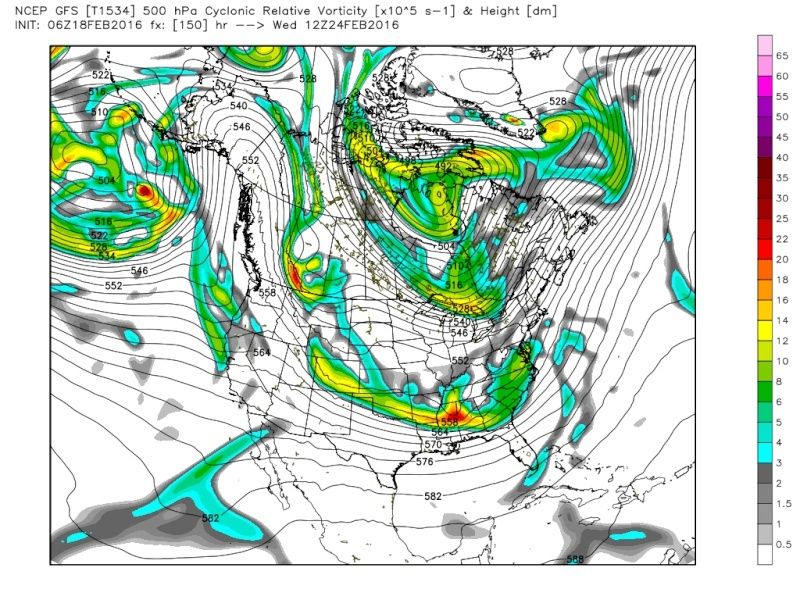
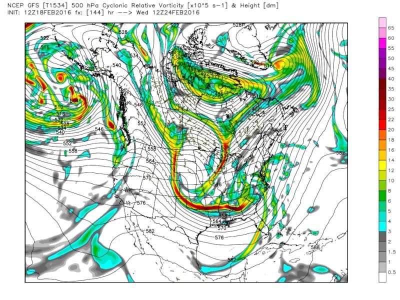
CMC:
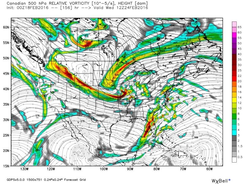
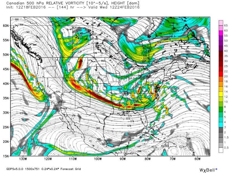
EURO:


I mean the changes from run to run are not subtle...they are drastic. You do not have to be an expert on the 500mb map to notice the differences from one run to another. Operational models are having a difficult time handling where to focus all the energy. Its going to take a few more days until we really see that dial in. The MJO forecast is still looking good. In fact the GEFS are actually correcting quite nicely. First image was the GEFS MJO forecast from yesterday; the second was from today. Hopefully GEFS cont to correct in this fashion. The third image is the Euro MJO forecast from today. The black circle is where the MJO is currently forecast to be around the time of our storm. In theory this should promote a colder soln as time goes on.
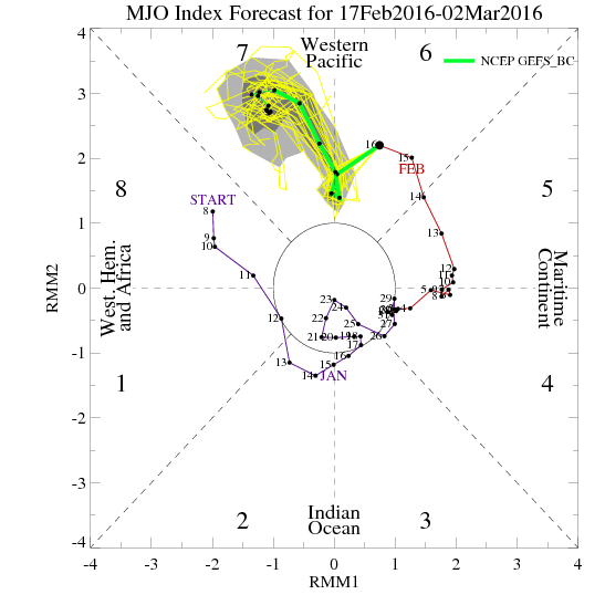


The sat image shows a huge burst of convection on the right ride of the image around the phase 8 trop Pac so in theory current observations supports the idea of the correction on the models of the MJO towards phase 8. Stay patient a cont to beware of the operational models flipping back and forth.

_________________
"In weather and in life, there's no winning and losing; there's only winning and learning."
WINTER 2012/2013 TOTALS 43.65"WINTER 2017/2018 TOTALS 62.85" WINTER 2022/2023 TOTALS 4.9"
WINTER 2013/2014 TOTALS 64.85"WINTER 2018/2019 TOTALS 14.25" WINTER 2023/2024 TOTALS 13.1"
WINTER 2014/2015 TOTALS 71.20"WINTER 2019/2020 TOTALS 6.35"
WINTER 2015/2016 TOTALS 35.00"WINTER 2020/2021 TOTALS 37.75"
WINTER 2016/2017 TOTALS 42.25"WINTER 2021/2022 TOTALS 31.65"

sroc4- Admin

- Posts : 8331
Reputation : 301
Join date : 2013-01-07
Location : Wading River, LI
Re: Long Range Thread 10.0
![]() by amugs Thu Feb 18, 2016 4:02 pm
by amugs Thu Feb 18, 2016 4:02 pm
My Pont above was the sun mon system indeed
It will help set up the next one
My idea was a bit more south and we above cnj cash on on the Monday storm, if not it looks to i287 N or an I 80 N type of storm. That Monday storm is there and I think it may be a nice surprise.
_________________
Mugs
AKA:King: Snow Weenie
Self Proclaimed
WINTER 2014-15 : 55.12" +.02 for 6 coatings (avg. 35")
WINTER 2015-16 Total - 29.8" (Avg 35")
WINTER 2016-17 : 39.5" so far
amugs- Advanced Forecaster - Mod
- Posts : 15093
Reputation : 213
Join date : 2013-01-07
Age : 54
Location : Hillsdale,NJ
Re: Long Range Thread 10.0
![]() by skinsfan1177 Thu Feb 18, 2016 4:06 pm
by skinsfan1177 Thu Feb 18, 2016 4:06 pm
Monday storm can set up a 50/50 low correct. Also weds. Big storm coastal areas as of today looki,g better correctamugs wrote:Great analysis Sroc.
My Pont above was the sun mon system indeed
It will help set up the next one
My idea was a bit more south and we above cnj cash on on the Monday storm, if not it looks to i287 N or an I 80 N type of storm. That Monday storm is there and I think it may be a nice surprise.

skinsfan1177- Senior Enthusiast
- Posts : 4485
Reputation : 35
Join date : 2013-01-07
Age : 46
Location : Point Pleasant Boro
Re: Long Range Thread 10.0
![]() by sroc4 Thu Feb 18, 2016 4:43 pm
by sroc4 Thu Feb 18, 2016 4:43 pm
skinsfan1177 wrote:Monday storm can set up a 50/50 low correct. Also weds. Big storm coastal areas as of today looki,g better correctamugs wrote:Great analysis Sroc.
My Pont above was the sun mon system indeed
It will help set up the next one
My idea was a bit more south and we above cnj cash on on the Monday storm, if not it looks to i287 N or an I 80 N type of storm. That Monday storm is there and I think it may be a nice surprise.
Im not sure its gong to be positioned correctly to be a true 50/50 Low. A 50/50 Low by definition is centered on or around 50N/50W. The first Low for Monday is off this map in the top right corner.

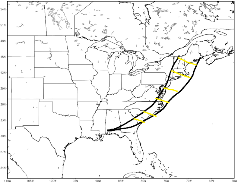
Here is my cone of uncertainty regarding the track of this storm as of now. Although I have to say the UKIE (which has done well this winter) although not quite in range yet is showing quite the amped soln. It it went out further it would be left of my cone of uncertainty. I believe the intensity of the LP will trend stronger again in the next few days.

_________________
"In weather and in life, there's no winning and losing; there's only winning and learning."
WINTER 2012/2013 TOTALS 43.65"WINTER 2017/2018 TOTALS 62.85" WINTER 2022/2023 TOTALS 4.9"
WINTER 2013/2014 TOTALS 64.85"WINTER 2018/2019 TOTALS 14.25" WINTER 2023/2024 TOTALS 13.1"
WINTER 2014/2015 TOTALS 71.20"WINTER 2019/2020 TOTALS 6.35"
WINTER 2015/2016 TOTALS 35.00"WINTER 2020/2021 TOTALS 37.75"
WINTER 2016/2017 TOTALS 42.25"WINTER 2021/2022 TOTALS 31.65"
sroc4- Admin
- Posts : 8331
Reputation : 301
Join date : 2013-01-07
Location : Wading River, LI
Re: Long Range Thread 10.0
![]() by CPcantmeasuresnow Thu Feb 18, 2016 5:00 pm
by CPcantmeasuresnow Thu Feb 18, 2016 5:00 pm
https://www.americanwx.com/bb/uploads/monthly_02_2016/post-9849-0-88500800-1455828692.png
CPcantmeasuresnow- Wx Statistician Guru
- Posts : 7274
Reputation : 230
Join date : 2013-01-07
Age : 103
Location : Eastern Orange County, NY
Re: Long Range Thread 10.0
![]() by sroc4 Thu Feb 18, 2016 5:09 pm
by sroc4 Thu Feb 18, 2016 5:09 pm
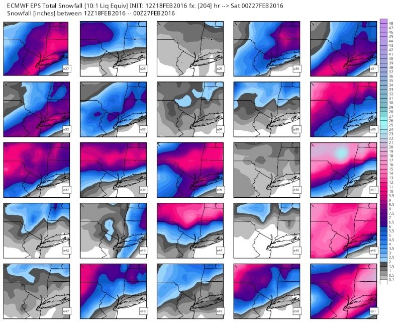
CPcantmeasuresnow wrote:Just for fun, the Euro snow map. Once again the HV in the bulls eye which proves the absurdity of this run.
https://www.americanwx.com/bb/uploads/monthly_02_2016/post-9849-0-88500800-1455828692.png
I have to say CP you have to look at the Ensebmles slight different from an operational map. That is an average of 51 members. That is a strong signal this far out. I would def be cautious however since we still have time. Ill one up it for you an post the individual members. Give me a sec
Last edited by sroc4 on Thu Feb 18, 2016 5:11 pm; edited 1 time in total
_________________
"In weather and in life, there's no winning and losing; there's only winning and learning."
WINTER 2012/2013 TOTALS 43.65"WINTER 2017/2018 TOTALS 62.85" WINTER 2022/2023 TOTALS 4.9"
WINTER 2013/2014 TOTALS 64.85"WINTER 2018/2019 TOTALS 14.25" WINTER 2023/2024 TOTALS 13.1"
WINTER 2014/2015 TOTALS 71.20"WINTER 2019/2020 TOTALS 6.35"
WINTER 2015/2016 TOTALS 35.00"WINTER 2020/2021 TOTALS 37.75"
WINTER 2016/2017 TOTALS 42.25"WINTER 2021/2022 TOTALS 31.65"
sroc4- Admin
- Posts : 8331
Reputation : 301
Join date : 2013-01-07
Location : Wading River, LI
Re: Long Range Thread 10.0
![]() by sroc4 Thu Feb 18, 2016 5:11 pm
by sroc4 Thu Feb 18, 2016 5:11 pm

_________________
"In weather and in life, there's no winning and losing; there's only winning and learning."
WINTER 2012/2013 TOTALS 43.65"WINTER 2017/2018 TOTALS 62.85" WINTER 2022/2023 TOTALS 4.9"
WINTER 2013/2014 TOTALS 64.85"WINTER 2018/2019 TOTALS 14.25" WINTER 2023/2024 TOTALS 13.1"
WINTER 2014/2015 TOTALS 71.20"WINTER 2019/2020 TOTALS 6.35"
WINTER 2015/2016 TOTALS 35.00"WINTER 2020/2021 TOTALS 37.75"
WINTER 2016/2017 TOTALS 42.25"WINTER 2021/2022 TOTALS 31.65"
sroc4- Admin
- Posts : 8331
Reputation : 301
Join date : 2013-01-07
Location : Wading River, LI
Re: Long Range Thread 10.0
![]() by amugs Thu Feb 18, 2016 5:20 pm
by amugs Thu Feb 18, 2016 5:20 pm

_________________
Mugs
AKA:King: Snow Weenie
Self Proclaimed
WINTER 2014-15 : 55.12" +.02 for 6 coatings (avg. 35")
WINTER 2015-16 Total - 29.8" (Avg 35")
WINTER 2016-17 : 39.5" so far
amugs- Advanced Forecaster - Mod
- Posts : 15093
Reputation : 213
Join date : 2013-01-07
Age : 54
Location : Hillsdale,NJ
Re: Long Range Thread 10.0
![]() by weatherwatchermom Thu Feb 18, 2016 6:28 pm
by weatherwatchermom Thu Feb 18, 2016 6:28 pm
bernie rayno today

weatherwatchermom- Senior Enthusiast
- Posts : 3738
Reputation : 77
Join date : 2014-11-25
Age : 60
Location : Hazlet Township, NJ
Re: Long Range Thread 10.0
![]() by rb924119 Thu Feb 18, 2016 6:40 pm
by rb924119 Thu Feb 18, 2016 6:40 pm
As for the next potential, this is the same one that I was focused on a while back, but it got shifted slightly further in time. That said, I am unsure of what to think at this point. Up until yesterday, things were looking good for it to have impacts on the area (winter weather-wise); the tropics were looking good, the Pacific was looking good, and the Atlantic was ehh, but we don’t necessarily need that. Yesterday, things trended poorly mainly with respect to the tropics and Pacific. Essentially, the blocky pattern out west was muted a bit by the tropical forcings, which had me concerned that the storm could either phase and cut to our west and end up a repeat of two days ago, or remain two separate entities with the first cutting and the second developing along the baroclinic zone from the first. Today, it appears that the trends reversed again, and look more like they were initially; with a nicely amplified Pacific. There are two things that worry me about this; though. The first is the projection of the MJO. Earlier, it was progged to enter a phase (
The second thing that concerns me is the state of the Stratospheric PV. It’s orientation is such that we are not located beneath a trough (lobe) of it; we are actually slightly under the influence of a lower-level Stratospheric ridge. This worries me because to me it signals that the air that will be flooding into the region brought in on the wings of the Pacific pattern will not be truly arctic in nature through the entirety of the atmospheric column. Sure, it may be cold at the surface, or to 700 hPa, but without the troughing of the Stratospheric PV overhead, to me that shows that it will not be very hard to advect warmer air into the system (if it develops). In terms of sensible impacts? Instead of having pure snow with a track on the 40/70 benchmark, it could in fact mix all the way to I-95. I think even with an offshore track, it will be a marginally cold column for snow, ESPECIALLY for areas near the coast. Depending on the eventual track, that area can of course change.
In a nutshell:
1. We have to monitor the progress and forecasts of the tropics (MJO). If it makes to Phase 8 before the storm, or even during its early development, that will help to promote more Eastern U.S. troughing, and more of a coastal/offshore track. If not, have to worry about it cutting west as Phase 7 promotes eastern ridging.
2. How blocky can the Pacific get?? The blockier, the higher the chance that it can override the MJO and shift the storm track further east.
3. My thoughts on storm track and NYC impacts as of now:
a. Apps runner/further west/all rain: 20%
b. On/very near the coast/front-end slop-rain-back-end snow: 35%
c. On/around the 40/70 Benchmark/Snow-mix-snow: 30%
d. Outside the 40/70 Benchmark or out to sea: 15%
This can all change overnight, but that’s what I think right now. I think we will see the models play “catch-up” to the speed with which the MJO is progressing through the equatorial pacific, and it will end up in Phase 8, which will allow the blocky Pacific to work in tandem with these forcings. Something else to note is the northwest trend that we have seen this season with systems. Note that today all of the Ensemble Means have the central pressure (means) slightly outside of the Benchmark. We have seen trends of between 75-125 miles northwest with the systems in the last month or so in the two days leading up to the events, so if that holds, then given current forecasts that further adds support to my thinking.
rb924119- Meteorologist

- Posts : 6889
Reputation : 194
Join date : 2013-02-06
Age : 32
Location : Greentown, Pa
Re: Long Range Thread 10.0
![]() by Guest Thu Feb 18, 2016 6:54 pm
by Guest Thu Feb 18, 2016 6:54 pm
What the hell's going on around here. Our leader is down and we have a storm or 2 coming. Unacceptable. Frank get your but back on here and tell us what we want to hear. In the words of the immortal Herb Brooks "a bruise on the leg (or in your case stomach) is a hell of a long way from the heart you candy ass!!:" Cmon Frank. Late winter rally cap time.

Guest- Guest
Re: Long Range Thread 10.0
![]() by Math23x7 Thu Feb 18, 2016 8:46 pm
by Math23x7 Thu Feb 18, 2016 8:46 pm
Math23x7- Wx Statistician Guru
- Posts : 2379
Reputation : 68
Join date : 2013-01-08
Re: Long Range Thread 10.0
![]() by amugs Thu Feb 18, 2016 8:57 pm
by amugs Thu Feb 18, 2016 8:57 pm
Math23x7 wrote:Toward the end of the 0Z SREF run, some plumes are sniffing a snow possibility late Sunday night into Monday.
mikey good catch 21z showing rain to ice to snow


_________________
Mugs
AKA:King: Snow Weenie
Self Proclaimed
WINTER 2014-15 : 55.12" +.02 for 6 coatings (avg. 35")
WINTER 2015-16 Total - 29.8" (Avg 35")
WINTER 2016-17 : 39.5" so far
amugs- Advanced Forecaster - Mod
- Posts : 15093
Reputation : 213
Join date : 2013-01-07
Age : 54
Location : Hillsdale,NJ
Re: Long Range Thread 10.0
![]() by amugs Thu Feb 18, 2016 9:03 pm
by amugs Thu Feb 18, 2016 9:03 pm


Last edited by amugs on Thu Feb 18, 2016 10:17 pm; edited 1 time in total
_________________
Mugs
AKA:King: Snow Weenie
Self Proclaimed
WINTER 2014-15 : 55.12" +.02 for 6 coatings (avg. 35")
WINTER 2015-16 Total - 29.8" (Avg 35")
WINTER 2016-17 : 39.5" so far
amugs- Advanced Forecaster - Mod
- Posts : 15093
Reputation : 213
Join date : 2013-01-07
Age : 54
Location : Hillsdale,NJ
Re: Long Range Thread 10.0
![]() by amugs Thu Feb 18, 2016 10:00 pm
by amugs Thu Feb 18, 2016 10:00 pm


_________________
Mugs
AKA:King: Snow Weenie
Self Proclaimed
WINTER 2014-15 : 55.12" +.02 for 6 coatings (avg. 35")
WINTER 2015-16 Total - 29.8" (Avg 35")
WINTER 2016-17 : 39.5" so far
amugs- Advanced Forecaster - Mod
- Posts : 15093
Reputation : 213
Join date : 2013-01-07
Age : 54
Location : Hillsdale,NJ
Re: Long Range Thread 10.0
![]() by amugs Thu Feb 18, 2016 10:02 pm
by amugs Thu Feb 18, 2016 10:02 pm

_________________
Mugs
AKA:King: Snow Weenie
Self Proclaimed
WINTER 2014-15 : 55.12" +.02 for 6 coatings (avg. 35")
WINTER 2015-16 Total - 29.8" (Avg 35")
WINTER 2016-17 : 39.5" so far
amugs- Advanced Forecaster - Mod
- Posts : 15093
Reputation : 213
Join date : 2013-01-07
Age : 54
Location : Hillsdale,NJ
Re: Long Range Thread 10.0
![]() by amugs Thu Feb 18, 2016 10:12 pm
by amugs Thu Feb 18, 2016 10:12 pm

_________________
Mugs
AKA:King: Snow Weenie
Self Proclaimed
WINTER 2014-15 : 55.12" +.02 for 6 coatings (avg. 35")
WINTER 2015-16 Total - 29.8" (Avg 35")
WINTER 2016-17 : 39.5" so far
amugs- Advanced Forecaster - Mod
- Posts : 15093
Reputation : 213
Join date : 2013-01-07
Age : 54
Location : Hillsdale,NJ
Re: Long Range Thread 10.0
![]() by amugs Thu Feb 18, 2016 10:17 pm
by amugs Thu Feb 18, 2016 10:17 pm
_________________
Mugs
AKA:King: Snow Weenie
Self Proclaimed
WINTER 2014-15 : 55.12" +.02 for 6 coatings (avg. 35")
WINTER 2015-16 Total - 29.8" (Avg 35")
WINTER 2016-17 : 39.5" so far
amugs- Advanced Forecaster - Mod
- Posts : 15093
Reputation : 213
Join date : 2013-01-07
Age : 54
Location : Hillsdale,NJ
Re: Long Range Thread 10.0
![]() by amugs Thu Feb 18, 2016 10:58 pm
by amugs Thu Feb 18, 2016 10:58 pm
Goes against the nam, euro and srefs
_________________
Mugs
AKA:King: Snow Weenie
Self Proclaimed
WINTER 2014-15 : 55.12" +.02 for 6 coatings (avg. 35")
WINTER 2015-16 Total - 29.8" (Avg 35")
WINTER 2016-17 : 39.5" so far
amugs- Advanced Forecaster - Mod
- Posts : 15093
Reputation : 213
Join date : 2013-01-07
Age : 54
Location : Hillsdale,NJ


Snow88- Senior Enthusiast
- Posts : 2193
Reputation : 4
Join date : 2013-01-09
Age : 35
Location : Brooklyn, NY
Page 23 of 28 • 1 ... 13 ... 22, 23, 24 ... 28 ![]()
|
|
|