
 Search
Long Range Thread 10.0
Page 26 of 28 •  1 ... 14 ... 25, 26, 27, 28
 ![]()
Re: Long Range Thread 10.0
![]() by Guest Fri Feb 19, 2016 9:52 pm
by Guest Fri Feb 19, 2016 9:52 pm
Guest- Guest
Re: Long Range Thread 10.0
![]() by Biggin23 Fri Feb 19, 2016 11:23 pm
by Biggin23 Fri Feb 19, 2016 11:23 pm
However, the model changes this winter seem to be massive. I have only been following the weather closely the last four years, but I don't think I have ever seen as many drastic changes and misses as this winter, so who know what can happen the rest of the way....
Biggin23- Posts : 259
Join date : 2015-02-11
Re: Long Range Thread 10.0
![]() by sroc4 Sat Feb 20, 2016 6:40 am
by sroc4 Sat Feb 20, 2016 6:40 am
Biggin23 wrote:GFS has the storm mid week in Ohio and Michigan. Not sure anything can happen drastic enough to bring it back this way.
However, the model changes this winter seem to be massive. I have only been following the weather closely the last four years, but I don't think I have ever seen as many drastic changes and misses as this winter, so who know what can happen the rest of the way....
You ain't kiddin Biggin. Atrocious is the word that comes to mind.
_________________
"In weather and in life, there's no winning and losing; there's only winning and learning."
WINTER 2012/2013 TOTALS 43.65"WINTER 2017/2018 TOTALS 62.85" WINTER 2022/2023 TOTALS 4.9"
WINTER 2013/2014 TOTALS 64.85"WINTER 2018/2019 TOTALS 14.25" WINTER 2023/2024 TOTALS 13.1"
WINTER 2014/2015 TOTALS 71.20"WINTER 2019/2020 TOTALS 6.35"
WINTER 2015/2016 TOTALS 35.00"WINTER 2020/2021 TOTALS 37.75"
WINTER 2016/2017 TOTALS 42.25"WINTER 2021/2022 TOTALS 31.65"

sroc4- Admin

- Posts : 8331
Reputation : 301
Join date : 2013-01-07
Location : Wading River, LI
Re: Long Range Thread 10.0
![]() by Frank_Wx Sat Feb 20, 2016 7:55 am
by Frank_Wx Sat Feb 20, 2016 7:55 am
No blocking!
The upper energy coming out of the Pacific is SO strong this season. H5 is closing off once it crosses the Rockies. This means the SE ridge amplifies ahead of the mean trough and the storm tracks well to our west as a result. The only way to combat this in El Nino regimes is to have a west-based -NAO. Not even a -EPO is enough to fight the STJ.
It is what it is. Hopefully March has more to offer.
_________________
_______________________________________________________________________________________________________
CLICK HERE to view NJ Strong Snowstorm Classifications

Frank_Wx- Godzilla Seeker
- Posts : 21305
Reputation : 328
Join date : 2013-01-05
Age : 31
Location : Jersey City, NJ -

Re: Long Range Thread 10.0
![]() by sroc4 Sat Feb 20, 2016 8:34 am
by sroc4 Sat Feb 20, 2016 8:34 am
Now normally when I see an operational model all over the place I look to its ensemble forecast to see if it has support. Remember the ensemble forecast is many runs averaged out. And low and behold both the GFS ensemble and the Euro ensemble means are way east of their operational forecasts.
00z GFS OP VS 00z GFS ENSEMBLE:

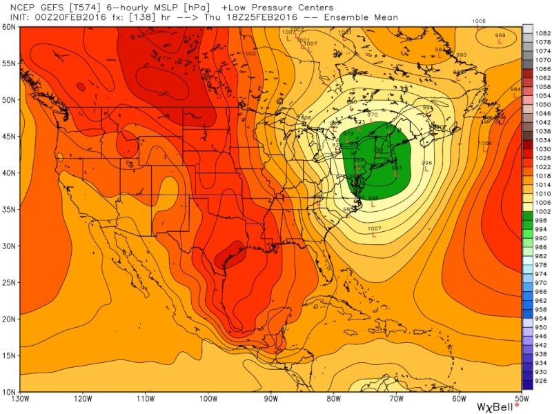
00z EURO OP VS 00z EURO ENSEMBLE:

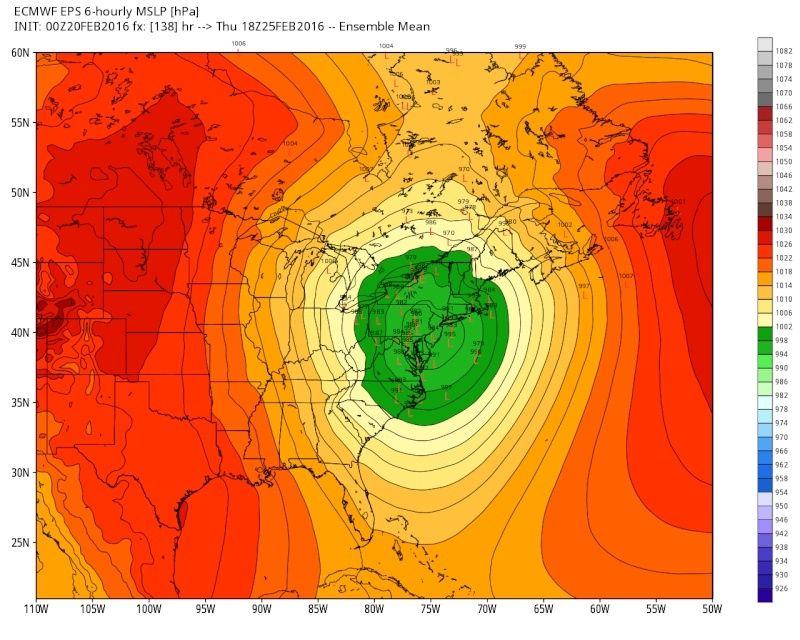
Now to be fair the Ukie which has been one of the better winter models this season has been consistent in its track through western NY/W PA which is west of the aforementioned ensembles but has shown a shift east with successive runs. I don't have 500mb for the Ukie, but both the Euro and GFS close off the system at 500mb early and the western track ensues from there.
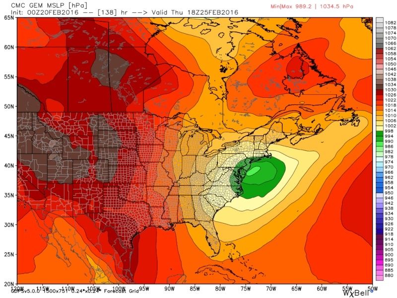
On the other hand the Canadian still has a track over Eastern LI:
Now one thing is becoming clear. There will most likely be an initial weaker wave that moves through the area on Tuesday; followed by the main event Wed-Thurs. If true this could be a game changer. So how do you make sense of it all. I mean you have operation models changing their storm track by hundreds of miles from run to run because the energy depiction at 500mb changes from run to run. Here is my take.
On Thursday afternoon this was my cone of uncertainty for the track put out before the shift west on the ensemble forecasts that ensued over night Thursday into Friday.
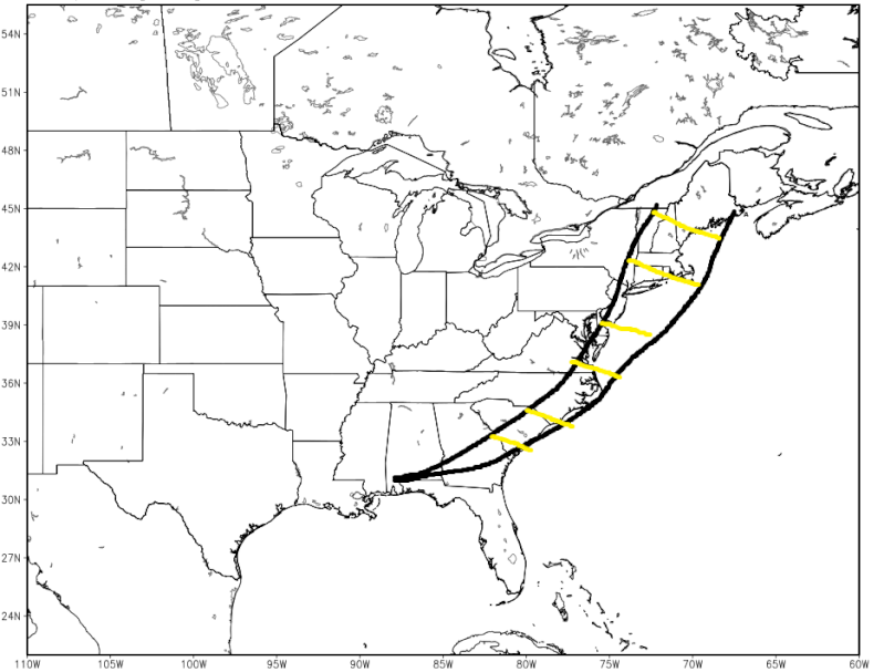
I am shifting my new cone of uncertainty west, but not by that much, about 100-125miles.
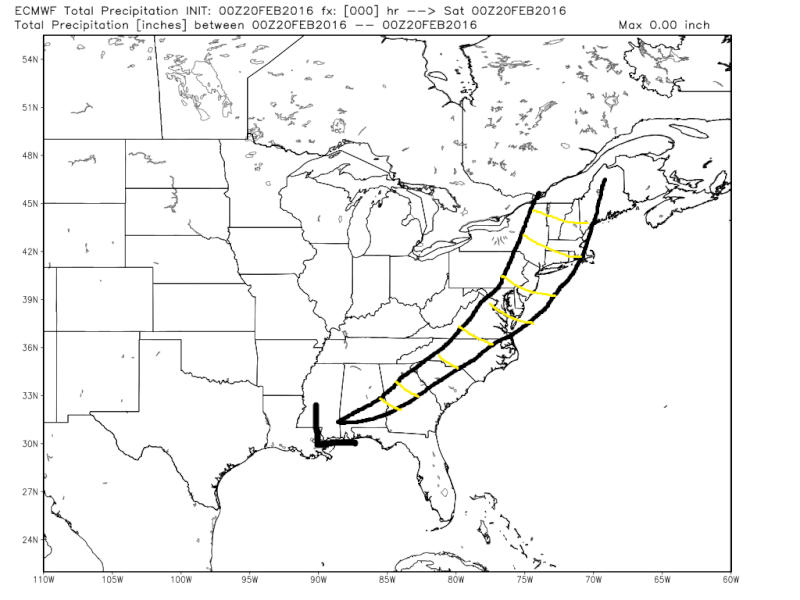
My track is based on a blend of the Ensemble mean and the CMC. As of now I am leaning to the left side of the storm track but this track is anything but a lock. There are a few other things to note. First, with so much uncertainty of the track who gets what and when and how and why, and how much simply cannot be answered. One thing I will say is if the weak wave followed by the main event unfolds like I think then watch the temp profiles trend colder and colder as we get inside 24-48hrs out. Look at the CMC and Euro surface map to get an idea why.
When the models lost the two wave idea there was nothing but a S/SE wind flow into the main system as it came up the coast:

In the next images pay little attention to the exact position of the LP but pay more attn. to the HP to the N. Slowly but surely with the trend towards this weak wave first followed by the stronger system second the HP that was modeled to be centered in the Canadian maritimesee above) is now trending stronger back west over NE. Instead we have the first wave move underneath the HP and now we have a stronger likely hood that a N/NE flow is still hanging on as second wave approaches if this hold true.
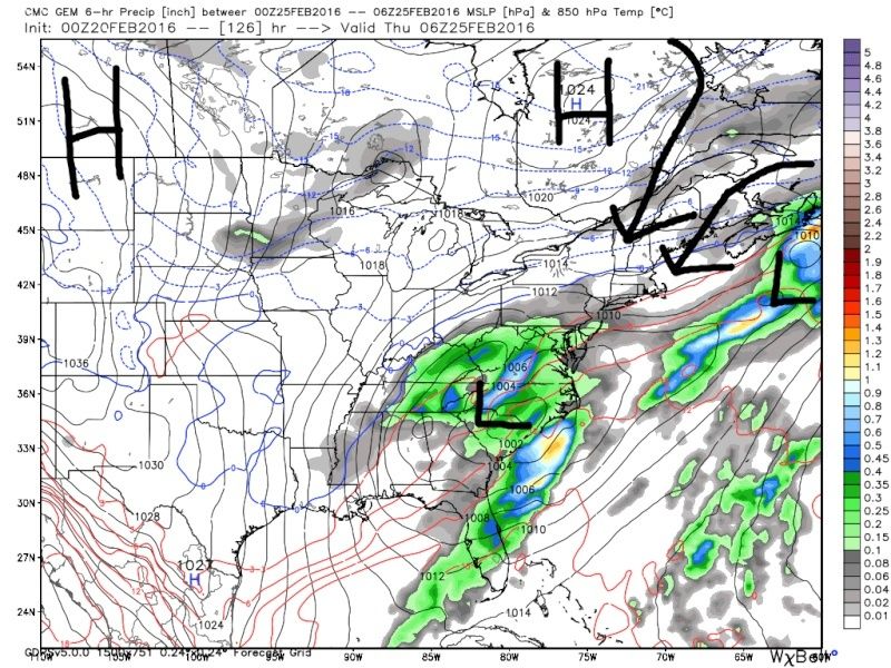

This trend tells me that if it were to cont as we approach zero hr for the second wave the temp profiles will trend colder as well. Nothing more than this general statement about temps can be made as we are way to far out. I could be way off in this assessment, but its what I am seeing this morning. The MJO forecast still supports the idea of a colder soln in my opinion, as does the ridge axis placement and strength in the western CONUS. Make no mistake I am not calling for a BM track, and in all likely hood the vast majority of us, esp the coastal plain changes over to rain, but this storm is not done yet trending for better or worse.
Last edited by sroc4 on Sat Feb 20, 2016 11:50 am; edited 1 time in total
_________________
"In weather and in life, there's no winning and losing; there's only winning and learning."
WINTER 2012/2013 TOTALS 43.65"WINTER 2017/2018 TOTALS 62.85" WINTER 2022/2023 TOTALS 4.9"
WINTER 2013/2014 TOTALS 64.85"WINTER 2018/2019 TOTALS 14.25" WINTER 2023/2024 TOTALS 13.1"
WINTER 2014/2015 TOTALS 71.20"WINTER 2019/2020 TOTALS 6.35"
WINTER 2015/2016 TOTALS 35.00"WINTER 2020/2021 TOTALS 37.75"
WINTER 2016/2017 TOTALS 42.25"WINTER 2021/2022 TOTALS 31.65"
sroc4- Admin
- Posts : 8331
Reputation : 301
Join date : 2013-01-07
Location : Wading River, LI
Re: Long Range Thread 10.0
![]() by skinsfan1177 Sat Feb 20, 2016 9:22 am
by skinsfan1177 Sat Feb 20, 2016 9:22 am

skinsfan1177- Senior Enthusiast

- Posts : 4485
Reputation : 35
Join date : 2013-01-07
Age : 46
Location : Point Pleasant Boro
Re: Long Range Thread 10.0
![]() by CPcantmeasuresnow Sat Feb 20, 2016 9:28 am
by CPcantmeasuresnow Sat Feb 20, 2016 9:28 am
I'm actually starting to understand the whole picture finally. It's only taken me what, 10 years since the accu weather chat board?

CPcantmeasuresnow- Wx Statistician Guru

- Posts : 7274
Reputation : 230
Join date : 2013-01-07
Age : 103
Location : Eastern Orange County, NY
Re: Long Range Thread 10.0
![]() by Radz Sat Feb 20, 2016 10:02 am
by Radz Sat Feb 20, 2016 10:02 am
TheAresian wrote:Look at the 12z NAM vs the 06z GFS for 00z Wednesday. One of those models is setting up to be horrendously wrong.
06zGFS
http://www.tropicaltidbits.com/analysis/models/gfs/2016022006/gfs_z500_vort_us_16.png
12z NAM
http://www.tropicaltidbits.com/analysis/models/namconus/2016022012/namconus_z500_vort_us_29.png
Or both will be horrendously wrong

Radz- Pro Enthusiast

- Posts : 1028
Reputation : 17
Join date : 2013-01-12
Location : Cortlandt Manor NY
Re: Long Range Thread 10.0
![]() by SoulSingMG Sat Feb 20, 2016 10:30 am
by SoulSingMG Sat Feb 20, 2016 10:30 am
"SPELL BINDING" (phrase of the day!)sroc4 wrote:I know many have lost interest in tracking this system because it has trended unfavorable for most, but now that I have had a chance to look at the 00z runs from last night it is truly mind boggling to me. First off I have to say the amount of inconsistency at both 500mb, and naturally at the surface, on the GFS and the Euro operational models with this system STILL run after run after run has been spell binding. It tells me that they are still out to lunch; esp the GFS. The GFS 06z this morning takes the LP on a track through eastern Indiana up through Michigan?????????. I am fairly confident that that wont happen so throw it out.
Now normally when I see an operational model all over the place I look to its ensemble forecast to see if it has support. Remember the ensemble forecast is many runs averaged out. And low and behold both the GFS ensemble and the Euro ensemble means are way east of their operational forecasts.
00z GFS OP VS 00z GFS ENSEMBLE:
00z EURO OP VS 00z EURO ENSEMBLE:
Now to be fair the Ukie which has been one of the better winter models this season has been consistent in its track through western NY/W PA which is west of the aforementioned ensembles but has shown a shift east with successive runs. I don't have 500mb for the Ukie, but both the Euro and GFS close off the system at 500mb early and the western track ensues from there.
On the other hand the Canadian still has a track over Eastern LI:
Now one thing is becoming clear. There will most likely be an initial weaker wave that moves through the area on Tuesday; followed by the main event Wed-Thurs. If true this could be a game changer. So how do you make sense of it all. I mean you have operation models changing their storm track by hundreds of miles from run to run because the energy depiction at 500mb changes from run to run. Here is my take.
On Thursday afternoon this was my cone of uncertainty for the track put out before the shift west on the ensemble forecasts that ensued over night Thursday into Friday.
I am shifting my new cone of uncertainty west, but not by that much, about 100-125miles.
My track is based on a blend of the Ensemble mean and the CMC. As of now I am leaning to the left side of the storm track but this track is anything but a lock. There are a few other things to note. First, with so much uncertainty of the track who gets what and when and how and why, and how much simply cannot be answered. One thing I will say is if the weak wave followed by the main event unfolds like I think then watch the temp profiles trend colder and colder as we get inside 24-48hrs out. Look at the CMC and Euro surface map to get an idea why.
When the models lost the two wave idea there was nothing but a S/SE wind flow into the main system as it came up the coast:
In the next images pay little attention to the exact position of the LP but pay more attn. to the HP to the N. Slowly but surely with the trend towards this weak wave first followed by the stronger system second the HP that was modeled to be centered in the Canadian maritimesee above) is now trending stronger back west over NE. Instead we have the first wave move underneath the HP and now we have a stronger likely hood that a N/NE flow is still hanging on as second wave approaches if this hold true.
This trend tells me that if it were to cont as we approach zero hr for the second wave the temp profiles will trend colder as well. Nothing more than this general statement about temps can be made as we are way to far out. I could be way off in this assessment, but its what I am seeing this morning. The MJO forecast still supports the idea of a colder soln in my opinion, as does the ridge axis placement and strength in the western CONUS. Make no mistake I am not calling for a BM track, and in all likely hood the vast majority of us, esp the coastal plain changes over to rain, but this storm is not done yet trending for better or worse.
Great write-up! Bernie Rayno agrees with you. Lots of changes still in store with this.

SoulSingMG- Senior Enthusiast
- Posts : 2853
Reputation : 74
Join date : 2013-12-11
Location : Long Island City, NY
Re: Long Range Thread 10.0
![]() by sroc4 Sat Feb 20, 2016 11:21 am
by sroc4 Sat Feb 20, 2016 11:21 am
_________________
"In weather and in life, there's no winning and losing; there's only winning and learning."
WINTER 2012/2013 TOTALS 43.65"WINTER 2017/2018 TOTALS 62.85" WINTER 2022/2023 TOTALS 4.9"
WINTER 2013/2014 TOTALS 64.85"WINTER 2018/2019 TOTALS 14.25" WINTER 2023/2024 TOTALS 13.1"
WINTER 2014/2015 TOTALS 71.20"WINTER 2019/2020 TOTALS 6.35"
WINTER 2015/2016 TOTALS 35.00"WINTER 2020/2021 TOTALS 37.75"
WINTER 2016/2017 TOTALS 42.25"WINTER 2021/2022 TOTALS 31.65"
sroc4- Admin
- Posts : 8331
Reputation : 301
Join date : 2013-01-07
Location : Wading River, LI
Re: Long Range Thread 10.0
![]() by CPcantmeasuresnow Sat Feb 20, 2016 11:30 am
by CPcantmeasuresnow Sat Feb 20, 2016 11:30 am
sroc4 wrote:Only a 350 miles shift east on 12z relative to 6z on the GFS
Only another 350 to go. Will probably get that tonight and we'll be golden, at least until tomorrow mornings.
CPcantmeasuresnow- Wx Statistician Guru
- Posts : 7274
Reputation : 230
Join date : 2013-01-07
Age : 103
Location : Eastern Orange County, NY
Re: Long Range Thread 10.0
![]() by sroc4 Sat Feb 20, 2016 11:52 am
by sroc4 Sat Feb 20, 2016 11:52 am
_________________
"In weather and in life, there's no winning and losing; there's only winning and learning."
WINTER 2012/2013 TOTALS 43.65"WINTER 2017/2018 TOTALS 62.85" WINTER 2022/2023 TOTALS 4.9"
WINTER 2013/2014 TOTALS 64.85"WINTER 2018/2019 TOTALS 14.25" WINTER 2023/2024 TOTALS 13.1"
WINTER 2014/2015 TOTALS 71.20"WINTER 2019/2020 TOTALS 6.35"
WINTER 2015/2016 TOTALS 35.00"WINTER 2020/2021 TOTALS 37.75"
WINTER 2016/2017 TOTALS 42.25"WINTER 2021/2022 TOTALS 31.65"
sroc4- Admin
- Posts : 8331
Reputation : 301
Join date : 2013-01-07
Location : Wading River, LI
Re: Long Range Thread 10.0
![]() by Frank_Wx Sat Feb 20, 2016 11:54 am
by Frank_Wx Sat Feb 20, 2016 11:54 am
_________________
_______________________________________________________________________________________________________
CLICK HERE to view NJ Strong Snowstorm Classifications
Frank_Wx- Godzilla Seeker
- Posts : 21305
Reputation : 328
Join date : 2013-01-05
Age : 31
Location : Jersey City, NJ -
rb924119- Meteorologist

- Posts : 6889
Reputation : 194
Join date : 2013-02-06
Age : 32
Location : Greentown, Pa
Re: Long Range Thread 10.0
![]() by Frank_Wx Sat Feb 20, 2016 12:01 pm
by Frank_Wx Sat Feb 20, 2016 12:01 pm

_________________
_______________________________________________________________________________________________________
CLICK HERE to view NJ Strong Snowstorm Classifications
Frank_Wx- Godzilla Seeker
- Posts : 21305
Reputation : 328
Join date : 2013-01-05
Age : 31
Location : Jersey City, NJ -
Re: Long Range Thread 10.0
![]() by sroc4 Sat Feb 20, 2016 12:04 pm
by sroc4 Sat Feb 20, 2016 12:04 pm
CPcantmeasuresnow wrote:Just an excellent write up Scott.
I'm actually starting to understand the whole picture finally. It's only taken me what, 10 years since the accu weather chat board?
Thanks BTW CP.
_________________
"In weather and in life, there's no winning and losing; there's only winning and learning."
WINTER 2012/2013 TOTALS 43.65"WINTER 2017/2018 TOTALS 62.85" WINTER 2022/2023 TOTALS 4.9"
WINTER 2013/2014 TOTALS 64.85"WINTER 2018/2019 TOTALS 14.25" WINTER 2023/2024 TOTALS 13.1"
WINTER 2014/2015 TOTALS 71.20"WINTER 2019/2020 TOTALS 6.35"
WINTER 2015/2016 TOTALS 35.00"WINTER 2020/2021 TOTALS 37.75"
WINTER 2016/2017 TOTALS 42.25"WINTER 2021/2022 TOTALS 31.65"
sroc4- Admin
- Posts : 8331
Reputation : 301
Join date : 2013-01-07
Location : Wading River, LI
Re: Long Range Thread 10.0
![]() by Frank_Wx Sat Feb 20, 2016 10:00 pm
by Frank_Wx Sat Feb 20, 2016 10:00 pm
_________________
_______________________________________________________________________________________________________
CLICK HERE to view NJ Strong Snowstorm Classifications
Frank_Wx- Godzilla Seeker
- Posts : 21305
Reputation : 328
Join date : 2013-01-05
Age : 31
Location : Jersey City, NJ -
Re: Long Range Thread 10.0
![]() by frank 638 Sat Feb 20, 2016 10:38 pm
by frank 638 Sat Feb 20, 2016 10:38 pm
frank 638- Senior Enthusiast
- Posts : 2824
Reputation : 37
Join date : 2016-01-01
Age : 40
Location : bronx ny
Re: Long Range Thread 10.0
![]() by Frank_Wx Sun Feb 21, 2016 8:49 am
by Frank_Wx Sun Feb 21, 2016 8:49 am
_________________
_______________________________________________________________________________________________________
CLICK HERE to view NJ Strong Snowstorm Classifications
Frank_Wx- Godzilla Seeker
- Posts : 21305
Reputation : 328
Join date : 2013-01-05
Age : 31
Location : Jersey City, NJ -
Re: Long Range Thread 10.0
![]() by weatherwatchermom Sun Feb 21, 2016 10:40 am
by weatherwatchermom Sun Feb 21, 2016 10:40 am
Frank_Wx wrote:LR guidance is hinting at a winter storm or two between the 28th and 3rd. Another arctic blast is expected the last few days of this month into March.
Good Morning Frank! Hope this morning finds you stronger..all I have to say to your comment above is from your mouth..to you know who's ears!! We need to go out with a bang!! for everyone!!

weatherwatchermom- Senior Enthusiast
- Posts : 3734
Reputation : 77
Join date : 2014-11-25
Age : 60
Location : Hazlet Township, NJ
Re: Long Range Thread 10.0
![]() by algae888 Sun Feb 21, 2016 12:15 pm
by algae888 Sun Feb 21, 2016 12:15 pm
here is one of them frank...Frank_Wx wrote:The Mo Mo will return Monday and it will discuss why February could end with a bang, and a preview of what March may be like.

cmc

gfs

algae888- Advanced Forecaster

- Posts : 5311
Reputation : 46
Join date : 2013-02-05
Age : 61
Location : mt. vernon, new york
Re: Long Range Thread 10.0
![]() by amugs Sun Feb 21, 2016 7:18 pm
by amugs Sun Feb 21, 2016 7:18 pm

_________________
Mugs
AKA:King: Snow Weenie
Self Proclaimed
WINTER 2014-15 : 55.12" +.02 for 6 coatings (avg. 35")
WINTER 2015-16 Total - 29.8" (Avg 35")
WINTER 2016-17 : 39.5" so far

amugs- Advanced Forecaster - Mod

- Posts : 15093
Reputation : 213
Join date : 2013-01-07
Age : 54
Location : Hillsdale,NJ
we are going back in the freezer while alaska and the northpole is going to bake but yes that is cold now can we get a snowstorm
![]() by frank 638 Sun Feb 21, 2016 7:49 pm
by frank 638 Sun Feb 21, 2016 7:49 pm
amugs wrote:Arctic blast Madonne -10 to 15 departures next weekend through the Beg of March if this serves
frank 638- Senior Enthusiast
- Posts : 2824
Reputation : 37
Join date : 2016-01-01
Age : 40
Location : bronx ny
Re: Long Range Thread 10.0
![]() by Math23x7 Sun Feb 21, 2016 8:28 pm
by Math23x7 Sun Feb 21, 2016 8:28 pm
frank 638 wrote:amugs wrote:Arctic blast Madonne -10 to 15 departures next weekend through the Beg of March if this serves
If it is going to be this cold in March, I want the snow. If we're not getting the snow, I would just like it to be warm, especially after March 13th as that's the day that Daylight Savings Time begins.
PS: frank638, with all due respect, when you post a reply on a thread, it is probably best to post it in the main portion of the message and not in the title portion. Just my opinion though.
Math23x7- Wx Statistician Guru
- Posts : 2379
Reputation : 68
Join date : 2013-01-08
Re: Long Range Thread 10.0
![]() by docstox12 Sun Feb 21, 2016 8:49 pm
by docstox12 Sun Feb 21, 2016 8:49 pm
Math23x7 wrote:frank 638 wrote:amugs wrote:Arctic blast Madonne -10 to 15 departures next weekend through the Beg of March if this serves
If it is going to be this cold in March, I want the snow. If we're not getting the snow, I would just like it to be warm, especially after March 13th as that's the day that Daylight Savings Time begins.
PS: frank638, with all due respect, when you post a reply on a thread, it is probably best to post it in the main portion of the message and not in the title portion. Just my opinion though.
Agreed.Sure hope it is not a cold, rainy spring.UGH!

docstox12- Wx Statistician Guru
- Posts : 8502
Reputation : 222
Join date : 2013-01-07
Age : 73
Location : Monroe NY
Re: Long Range Thread 10.0
![]() by Math23x7 Sun Feb 21, 2016 8:55 pm
by Math23x7 Sun Feb 21, 2016 8:55 pm
docstox12 wrote:Math23x7 wrote:frank 638 wrote:amugs wrote:Arctic blast Madonne -10 to 15 departures next weekend through the Beg of March if this serves
If it is going to be this cold in March, I want the snow. If we're not getting the snow, I would just like it to be warm, especially after March 13th as that's the day that Daylight Savings Time begins.
PS: frank638, with all due respect, when you post a reply on a thread, it is probably best to post it in the main portion of the message and not in the title portion. Just my opinion though.
Agreed.Sure hope it is not a cold, rainy spring.UGH!
I would take March 2012 (no snow and the 2nd warmest March on record for CPK) over March 2014 (cold with only 0.1" of snow, which came from a system that days earlier was forecasted to give NYC 6-12" of snow.)
Math23x7- Wx Statistician Guru
- Posts : 2379
Reputation : 68
Join date : 2013-01-08
Re: Long Range Thread 10.0
![]() by Guest Sun Feb 21, 2016 9:25 pm
by Guest Sun Feb 21, 2016 9:25 pm
Guest- Guest
Page 26 of 28 • 1 ... 14 ... 25, 26, 27, 28 ![]()
|
|
|