
 Search
Hurricane Hermine Discussion
Page 4 of 40 •  1, 2, 3, 4, 5 ... 22 ... 40
 ![]()
Re: Hurricane Hermine Discussion
![]() by weatherwatchermom Tue Aug 30, 2016 6:22 pm
by weatherwatchermom Tue Aug 30, 2016 6:22 pm
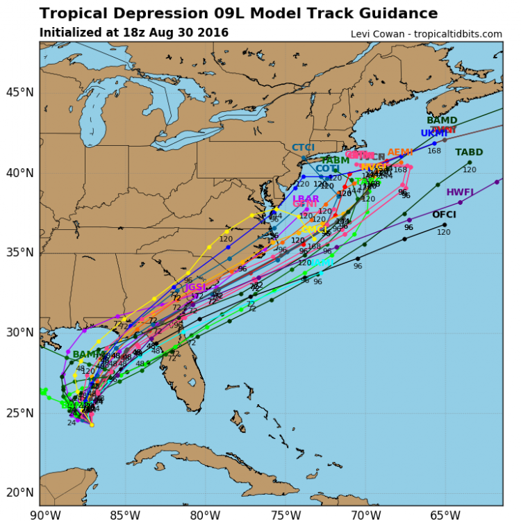
Snow88 wrote:jmanley32 wrote:I missed that guess updated bit after 5. That's a big change in cone. Nhc buying the curve to some extent now. I'm not asking if this is going to b a sandy but is it the same setup? The one they said was 100 years rare?Snow88 wrote:NHC west of their previous update
http://www.nhc.noaa.gov/refresh/graphics_at4+shtml/152206.shtml?5-daynl#contents
I think there was a lot more blocking with Sandy than now
the video I posted in Banter has a good explanation of Sandy and what made it a superstorm...along with footage of the area
weatherwatchermom- Senior Enthusiast

- Posts : 3733
Join date : 2014-11-25
Re: Hurricane Hermine Discussion
![]() by aiannone Tue Aug 30, 2016 6:43 pm
by aiannone Tue Aug 30, 2016 6:43 pm
amugs wrote:
Looky see big HP to our North SE or more East Can
Blue for $1000 Alex?
I'll take it! I'll drive home from school for it lol!
aiannone- Senior Enthusiast - Mod

- Posts : 4813
Join date : 2013-01-07
Re: Hurricane Hermine Discussion
![]() by Quietace Tue Aug 30, 2016 6:49 pm
by Quietace Tue Aug 30, 2016 6:49 pm
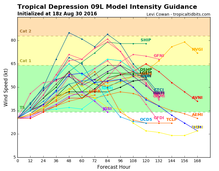
That sounds about right given intensity guidance. Now given if there was such a interaction with the mid lat trough it probably would be a hybrid/subtropical cyclone such that its intensity would certainty vary away from guidance.jmanley32 wrote:Watching twc. I know don't kill me. Has 70mph ts in the northern most part of cone.

Quietace- Meteorologist - Mod

- Posts : 3687
Reputation : 33
Join date : 2013-01-07
Age : 27
Location : Point Pleasant, NJ
Re: Hurricane Hermine Discussion
![]() by jmanley32 Tue Aug 30, 2016 7:08 pm
by jmanley32 Tue Aug 30, 2016 7:08 pm
Quietace wrote:That sounds about right given intensity guidance. Now given if there was such a interaction with the mid lat trough it probably would be a hybrid/subtropical cyclone such that its intensity would certainty vary away from guidance.jmanley32 wrote:Watching twc. I know don't kill me. Has 70mph ts in the northern most part of cone.
It couldnt maintain tropical structure up to this latitude this time of year? Its also stacking and the LLC and mid level are coming together, sign its getting its act together.

jmanley32- Senior Enthusiast
- Posts : 20512
Reputation : 108
Join date : 2013-12-12
Age : 42
Location : Yonkers, NY
Re: Hurricane Hermine Discussion
![]() by jmanley32 Tue Aug 30, 2016 7:09 pm
by jmanley32 Tue Aug 30, 2016 7:09 pm
aiannone wrote:amugs wrote:
Looky see big HP to our North SE or more East Can
Blue for $1000 Alex?
I'll take it! I'll drive home from school for it lol!
sorry mugs I don't get it. blue?
jmanley32- Senior Enthusiast
- Posts : 20512
Reputation : 108
Join date : 2013-12-12
Age : 42
Location : Yonkers, NY
Re: Hurricane Hermine Discussion
![]() by jmanley32 Tue Aug 30, 2016 7:16 pm
by jmanley32 Tue Aug 30, 2016 7:16 pm
http://www.ssd.noaa.gov/PS/TROP/floaters/09L/imagery/rb_lalo-animated.gif
jmanley32- Senior Enthusiast
- Posts : 20512
Reputation : 108
Join date : 2013-12-12
Age : 42
Location : Yonkers, NY
Re: Hurricane Hermine Discussion
![]() by rb924119 Tue Aug 30, 2016 7:16 pm
by rb924119 Tue Aug 30, 2016 7:16 pm
jmanley32 wrote:Quietace wrote:That sounds about right given intensity guidance. Now given if there was such a interaction with the mid lat trough it probably would be a hybrid/subtropical cyclone such that its intensity would certainty vary away from guidance.jmanley32 wrote:Watching twc. I know don't kill me. Has 70mph ts in the northern most part of cone.
It couldnt maintain tropical structure up to this latitude this time of year? Its also stacking and the LLC and mid level are coming together, sign its getting its act together.
It absolutely could. You're missing what he means. He's saying that if it started interacting with a favorably located jet and vorticity and such, because of those interactions, by definition it would no longer be considered tropical. Tropical has no involvement with baroclinic environments (i.e. temperature gradients that are directly responsible for the jet structure and evolution of mid-latitude patterns). If it did have an interaction, he is saying that the hurricane guidance would likely not be able to pick up on any enhancement due to a strong interaction with the mid-latitude structures (extra-tropical transition) because they are not designed to incorporate those types of dynamics. They are designed for tropical development. Make sense?
rb924119- Meteorologist

- Posts : 6889
Reputation : 194
Join date : 2013-02-06
Age : 32
Location : Greentown, Pa
Re: Hurricane Hermine Discussion
![]() by Quietace Tue Aug 30, 2016 7:20 pm
by Quietace Tue Aug 30, 2016 7:20 pm
Exactly. Thank you.rb924119 wrote:jmanley32 wrote:Quietace wrote:That sounds about right given intensity guidance. Now given if there was such a interaction with the mid lat trough it probably would be a hybrid/subtropical cyclone such that its intensity would certainty vary away from guidance.jmanley32 wrote:Watching twc. I know don't kill me. Has 70mph ts in the northern most part of cone.
It couldnt maintain tropical structure up to this latitude this time of year? Its also stacking and the LLC and mid level are coming together, sign its getting its act together.
It absolutely could. You're missing what he means. He's saying that if it started interacting with a favorably located jet and vorticity and such, because of those interactions, by definition it would no longer be considered tropical. Tropical has no involvement with baroclinic environments (i.e. temperature gradients that are directly responsible for the jet structure and evolution of mid-latitude patterns). If it did have an interaction, he is saying that the hurricane guidance would likely not be able to pick up on any enhancement due to a strong interaction with the mid-latitude structures (extra-tropical transition) because they are not designed to incorporate those types of dynamics. They are designed for tropical development. Make sense?
Quietace- Meteorologist - Mod
- Posts : 3687
Reputation : 33
Join date : 2013-01-07
Age : 27
Location : Point Pleasant, NJ
Re: Hurricane Hermine Discussion
![]() by jmanley32 Tue Aug 30, 2016 7:21 pm
by jmanley32 Tue Aug 30, 2016 7:21 pm
rb924119 wrote:jmanley32 wrote:Quietace wrote:That sounds about right given intensity guidance. Now given if there was such a interaction with the mid lat trough it probably would be a hybrid/subtropical cyclone such that its intensity would certainty vary away from guidance.jmanley32 wrote:Watching twc. I know don't kill me. Has 70mph ts in the northern most part of cone.
It couldnt maintain tropical structure up to this latitude this time of year? Its also stacking and the LLC and mid level are coming together, sign its getting its act together.
It absolutely could. You're missing what he means. He's saying that if it started interacting with a favorably located jet and vorticity and such, because of those interactions, by definition it would no longer be considered tropical. Tropical has no involvement with baroclinic environments (i.e. temperature gradients that are directly responsible for the jet structure and evolution of mid-latitude patterns). If it did have an interaction, he is saying that the hurricane guidance would likely not be able to pick up on any enhancement due to a strong interaction with the mid-latitude structures (extra-tropical transition) because they are not designed to incorporate those types of dynamics. They are designed for tropical development. Make sense?
Kind of so basically, models could be off due to the differences in handling the different types tropical or hybrid? So we may not see final solution until very close.
jmanley32- Senior Enthusiast
- Posts : 20512
Reputation : 108
Join date : 2013-12-12
Age : 42
Location : Yonkers, NY
Re: Hurricane Hermine Discussion
![]() by jmanley32 Tue Aug 30, 2016 7:22 pm
by jmanley32 Tue Aug 30, 2016 7:22 pm
jmanley32- Senior Enthusiast
- Posts : 20512
Reputation : 108
Join date : 2013-12-12
Age : 42
Location : Yonkers, NY
Re: Hurricane Hermine Discussion
![]() by rb924119 Tue Aug 30, 2016 7:32 pm
by rb924119 Tue Aug 30, 2016 7:32 pm
jmanley32 wrote:rb924119 wrote:jmanley32 wrote:Quietace wrote:That sounds about right given intensity guidance. Now given if there was such a interaction with the mid lat trough it probably would be a hybrid/subtropical cyclone such that its intensity would certainty vary away from guidance.jmanley32 wrote:Watching twc. I know don't kill me. Has 70mph ts in the northern most part of cone.
It couldnt maintain tropical structure up to this latitude this time of year? Its also stacking and the LLC and mid level are coming together, sign its getting its act together.
It absolutely could. You're missing what he means. He's saying that if it started interacting with a favorably located jet and vorticity and such, because of those interactions, by definition it would no longer be considered tropical. Tropical has no involvement with baroclinic environments (i.e. temperature gradients that are directly responsible for the jet structure and evolution of mid-latitude patterns). If it did have an interaction, he is saying that the hurricane guidance would likely not be able to pick up on any enhancement due to a strong interaction with the mid-latitude structures (extra-tropical transition) because they are not designed to incorporate those types of dynamics. They are designed for tropical development. Make sense?
Kind of so basically, models could be off due to the differences in handling the different types tropical or hybrid? So we may not see final solution until very close.
In a nutshell, yes haha If it was me, the way I would look at it is this: In today's runs, I would follow all guidance, but weight the hurricane models (tracks/intensities) more than the global suites (GFS/EURO/etc), something like a 70/30 split, mainly because it is a purely tropical entity at this point. I would continue this until it starts showing an interaction with whatever the mid-latitudes do (or if they do at all) in today's runs (for example through hour 84 or 78, or something like that). Once to that point, I would start weighting the globals more heavily, going from 70/30 to 60/40 to 50/50 so on and so forth as you look further in time, because at those times it won't necessarily be entirely tropical, and I think the globals have a better handle on its development at that point in time. I would still consider the hurricane guidance, just not necessarily as heavily as in the beginning. That's just an example, though, of how I might look at it with respect to figuring out its possible intensity and track. I think it would help to limit the amount of error, versus just following one type of model or the other. Blends are wonderful things haha
rb924119- Meteorologist
- Posts : 6889
Reputation : 194
Join date : 2013-02-06
Age : 32
Location : Greentown, Pa
Re: Hurricane Hermine Discussion
![]() by amugs Tue Aug 30, 2016 11:21 pm
by amugs Tue Aug 30, 2016 11:21 pm

_________________
Mugs
AKA:King: Snow Weenie
Self Proclaimed
WINTER 2014-15 : 55.12" +.02 for 6 coatings (avg. 35")
WINTER 2015-16 Total - 29.8" (Avg 35")
WINTER 2016-17 : 39.5" so far

amugs- Advanced Forecaster - Mod
- Posts : 15093
Reputation : 213
Join date : 2013-01-07
Age : 54
Location : Hillsdale,NJ
Re: Hurricane Hermine Discussion
![]() by Snow88 Wed Aug 31, 2016 12:21 am
by Snow88 Wed Aug 31, 2016 12:21 am
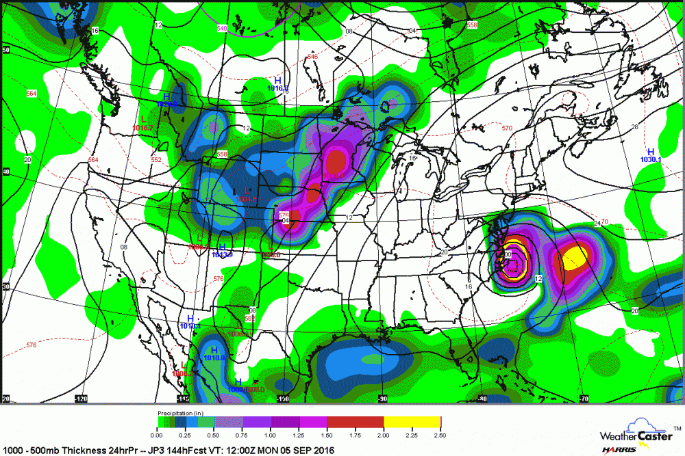
GFS goes northeast from the Carolinas and doesn't hit the Northeast.

Snow88- Senior Enthusiast
- Posts : 2193
Reputation : 4
Join date : 2013-01-09
Age : 35
Location : Brooklyn, NY
Re: Hurricane Hermine Discussion
![]() by Snow88 Wed Aug 31, 2016 12:43 am
by Snow88 Wed Aug 31, 2016 12:43 am
Goodnight
Not a good trend tonight if you want to see a storm up here in the Northeast.
Snow88- Senior Enthusiast
- Posts : 2193
Reputation : 4
Join date : 2013-01-09
Age : 35
Location : Brooklyn, NY
Re: Hurricane Hermine Discussion
![]() by sroc4 Wed Aug 31, 2016 6:58 am
by sroc4 Wed Aug 31, 2016 6:58 am
sroc4 wrote:rb924119 wrote:I honestly am not buying a retrograding storm in this scenario. Can't give a huge explanation because I'm at work, but if you look at the 500 hPa anomalies for the Northern Hemisphere centered over North America, you have the following: Strongly positive EPO, strongly negative PNA and absolutely zero Atlantic blocking. How does this help when discussing tropics? The GFS solution, specifically today's 12z, is heavily reliant upon a piece of this weekend's trough digging far into the Southeastern States and interacting with the tropical entity enough so that it prevents it from getting embedded in the westerlies of the lifting and progressive trough. Instead, this interaction allows a cyclogenesis event similar to what we can see in the winter (with respect to the track) where the trough goes from a positive tilt, to neutral, to nearly negative, before it finally becomes embedded in the westerlies at our latitude. However, it is obviously different in the fact that this a tropical entity, so the reasons for why the trough is able to change orientations are different (here, the ridge wave breaks over the top of the entity and then is reinforced by the diabatic heat release from the convection of the system).
The reason that I don't buy this solution is because none of the factors I highlighted at the beginning; the strongly positive EPO, strongly negative PNA and no Atlantic blocking do not support energy digging even remotely close to deep enough to allow this type of interaction to occur. A bit concerning, by the same token, is that the GFS has had the best handle on this system regarding its intensity to date. Just my quick opinion. Feel free to discuss lol
I def have some thoughts both for and against your argument, but not enough time to discuss at the moment. I can see it both ways depending on trends at 500mb
Hey Rb. Let me start by saying I prev thought and still believe that ultimately this will swing and miss most if not all of the NE, but a few points to be made. First is that the models have been in fair agreement, GFS, Euro operationals and their ensembles, that the main energy from TD 9 will be left behind at some point from the trough. I do believe that a retrograde towards the coast is def possible. Not however in a Sandy esque fashion where we get a phase with the trough and a full neg tilt etc, but rather IF, and its a big IF, the timing of the system with the trough is off it gets left behind cutoff from the main flow. Afterall it is a tropical system; not a run of the mill LP off the coast. Although the -NAO blocking is not present its actually the -PNA that sets this potential up. Here is the 500mb anomalies from the CMC showing my points:
First frame: Trough digging S of Aleutians building ridge into GOA consequently digging trough ito the west coast (-PNA) which argues for Ridging along the east coast.
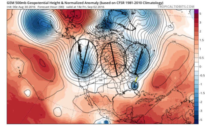
Therefore the trough that digs into the EC tugging our little fiend TD 9 North has NO staying power; is progressive (as seen by extreme positive tilt) and so lifts up and out into the N Atlantic very quickly. See next fram below. In its wake HP will want to build; however there is a weakness that our system heads for left behind in between the Sub tropical ridge and the ridge over the N CONUS/E Canada
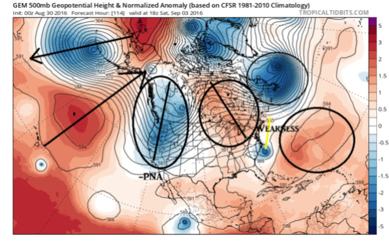
HOWEVER, The CMC soln from 24hrs ago the ridge builds in rapidly in the wake of the exiting trough and in front of the system effectively cutting it off from the main flow and trapping/blocking its exit.

This is in fact in response to the -PNA establishing itself. Strong trough in the west ridge response in the east. Result is a system that gets turned back towards the coast in response to the approaching trough

Now lets be clear here....TIMING IS EVERYTHING. TD 9 still would likely still need to slow down some from its current forecast in order to miss the trough and leave it close enough to the coast to have it retrograde enough to have an impact in the NE. That said, and I mentioned above, there is good agreement for now, that it will in fact be left behind and be cutoff from the main westerly's for a brief time until the next trough picks it up and officially takes it away into the N Atlantic. And there looks to be a gentle turn back N and/or NW as it feels the approaching trough before its swept away. Timing will be key here. Remember models have been doing a poor job overall beyond day 3 so take it all with a grain of salt and keep monitoring for trends. Heck...Euro once again has TD 9 ramping up to a strong 980mb Cat 1 at landfall with gusts to 90+ MPH; whereas the GFS still has it as a 1004mb TS or TD still with winds half that and we are only 2 DAYS!! away. Bottom line.....WE TRACK!!


Last edited by sroc4 on Sun Sep 04, 2016 7:55 am; edited 1 time in total
_________________
"In weather and in life, there's no winning and losing; there's only winning and learning."
WINTER 2012/2013 TOTALS 43.65"WINTER 2017/2018 TOTALS 62.85" WINTER 2022/2023 TOTALS 4.9"
WINTER 2013/2014 TOTALS 64.85"WINTER 2018/2019 TOTALS 14.25" WINTER 2023/2024 TOTALS 13.1"
WINTER 2014/2015 TOTALS 71.20"WINTER 2019/2020 TOTALS 6.35"
WINTER 2015/2016 TOTALS 35.00"WINTER 2020/2021 TOTALS 37.75"
WINTER 2016/2017 TOTALS 42.25"WINTER 2021/2022 TOTALS 31.65"

sroc4- Admin

- Posts : 8331
Reputation : 301
Join date : 2013-01-07
Location : Wading River, LI
Re: Hurricane Hermine Discussion
![]() by jmanley32 Wed Aug 31, 2016 7:09 am
by jmanley32 Wed Aug 31, 2016 7:09 am
jmanley32- Senior Enthusiast
- Posts : 20512
Reputation : 108
Join date : 2013-12-12
Age : 42
Location : Yonkers, NY
Re: Hurricane Hermine Discussion
![]() by weatherwatchermom Wed Aug 31, 2016 7:17 am
by weatherwatchermom Wed Aug 31, 2016 7:17 am

weatherwatchermom- Senior Enthusiast
- Posts : 3733
Reputation : 77
Join date : 2014-11-25
Age : 60
Location : Hazlet Township, NJ
Re: Hurricane Hermine Discussion
![]() by WOLVES1 Wed Aug 31, 2016 7:32 am
by WOLVES1 Wed Aug 31, 2016 7:32 am

WOLVES1- Posts : 103
Reputation : 0
Join date : 2013-01-10
Age : 52
Location : Malverne NY
Re: Hurricane Hermine Discussion
![]() by sroc4 Wed Aug 31, 2016 8:06 am
by sroc4 Wed Aug 31, 2016 8:06 am
1) An upper level anticyclone is currently centered right over the top of the system( blue wind barbs pointing out from the center of the circulation in a clockwise fashion) which is a check mark towards intensification.

2) For the moment wind shear is mild to mod at best with the heaviest shear well to the N of the system along the gulf coast and to the west over the Fla straits.

3) strong bursts of convection this morning concentrated and centered over or very near the LLC.

You can see two really nice out flow channels on the N NE and S SW sides of the system. A sign of organization.

4) The LLC and the Mid level centers are getting very close to becoming stacked over top of one another.
This loop and green circle shows the LLC at the surface:
https://earth.nullschool.net/#current/wind/surface/level/orthographic=-83.73,25.17,1921/loc=-88.388,24.310
Green circle on this is still the LLC but the loop is now at 850mb (approx. 5000ft up). Notice the two are stacked on top of each other.
https://earth.nullschool.net/#current/wind/isobaric/850hPa/orthographic=-83.73,25.17,1921/loc=-88.388,24.310
This loop the green circle is still centered over the LLC but you can see the Mid level circulation (500mb or approx. 18,000ft up) is still just SE of the LLC but this is the closest its been to the LLC since we have been following.
https://earth.nullschool.net/#current/wind/isobaric/500hPa/orthographic=-83.73,25.17,1921/loc=-88.388,24.310
5) Finally models are in good agreement about the development and favorable positioning of an upper level jet streak which could aid in intensification just before landfall and also aid in a lack of weakening or even further intensification while over land and certainly if the system re-emerges just off the SE coast.

This aspect of the storm is usually something we talk about in winter when we see the bombing out of a Nor easter as it rides the coast. Check out Levi Cowan's latest video to see a nice explanation about this:
http://www.tropicaltidbits.com/
This thing is getting very close, if not already due to the reasons mentioned above, to be able to feed back on itself meaning the system may be able to overcome some of the neg things that have been holding it back thus far ie: dry air on the NW side, shear on the northern side, and decoupled low levels and mid level circulations. I would also say that chances that an unexpected intensification beyond a Cat 1 is not zero, although unlikely at this time.
_________________
"In weather and in life, there's no winning and losing; there's only winning and learning."
WINTER 2012/2013 TOTALS 43.65"WINTER 2017/2018 TOTALS 62.85" WINTER 2022/2023 TOTALS 4.9"
WINTER 2013/2014 TOTALS 64.85"WINTER 2018/2019 TOTALS 14.25" WINTER 2023/2024 TOTALS 13.1"
WINTER 2014/2015 TOTALS 71.20"WINTER 2019/2020 TOTALS 6.35"
WINTER 2015/2016 TOTALS 35.00"WINTER 2020/2021 TOTALS 37.75"
WINTER 2016/2017 TOTALS 42.25"WINTER 2021/2022 TOTALS 31.65"
sroc4- Admin
- Posts : 8331
Reputation : 301
Join date : 2013-01-07
Location : Wading River, LI
Re: Hurricane Hermine Discussion
![]() by jmanley32 Wed Aug 31, 2016 8:13 am
by jmanley32 Wed Aug 31, 2016 8:13 am
Last edited by jmanley32 on Wed Aug 31, 2016 8:27 am; edited 1 time in total
jmanley32- Senior Enthusiast
- Posts : 20512
Reputation : 108
Join date : 2013-12-12
Age : 42
Location : Yonkers, NY
Re: Hurricane Hermine Discussion
![]() by jmanley32 Wed Aug 31, 2016 8:26 am
by jmanley32 Wed Aug 31, 2016 8:26 am

jmanley32- Senior Enthusiast
- Posts : 20512
Reputation : 108
Join date : 2013-12-12
Age : 42
Location : Yonkers, NY
Re: Hurricane Hermine Discussion
![]() by jmanley32 Wed Aug 31, 2016 8:30 am
by jmanley32 Wed Aug 31, 2016 8:30 am

jmanley32- Senior Enthusiast
- Posts : 20512
Reputation : 108
Join date : 2013-12-12
Age : 42
Location : Yonkers, NY
Re: Hurricane Hermine Discussion
![]() by sroc4 Wed Aug 31, 2016 8:36 am
by sroc4 Wed Aug 31, 2016 8:36 am
jmanley32 wrote:Sroc when do you think we will have a better idea of if and when we get a turn into the area? 06z gfs was one strongest yet and brings strong ts conditions to most the area though not extremely far inland. And as mugs posted gefs Def shoe that position on sun/monday. Fl I think takes anything under cat 2 as a regular day. Or so says my family.in Vero beach. But ya it looks impressive this morning and I'd b surprised if not a ts by 11am.
My guess would be some time after we see landfall. As far as what residents think about a cat one or TS vs above cat 2 is not the point. If residents in low lying areas expect a storm surge of a few feet but a strong Cat 1 produces a bigger surge than expected then that is something. The surge on the east side in a Weak TS vs a strong Cat 1 could be more serious than the winds themselves.
_________________
"In weather and in life, there's no winning and losing; there's only winning and learning."
WINTER 2012/2013 TOTALS 43.65"WINTER 2017/2018 TOTALS 62.85" WINTER 2022/2023 TOTALS 4.9"
WINTER 2013/2014 TOTALS 64.85"WINTER 2018/2019 TOTALS 14.25" WINTER 2023/2024 TOTALS 13.1"
WINTER 2014/2015 TOTALS 71.20"WINTER 2019/2020 TOTALS 6.35"
WINTER 2015/2016 TOTALS 35.00"WINTER 2020/2021 TOTALS 37.75"
WINTER 2016/2017 TOTALS 42.25"WINTER 2021/2022 TOTALS 31.65"
sroc4- Admin
- Posts : 8331
Reputation : 301
Join date : 2013-01-07
Location : Wading River, LI
Re: Hurricane Hermine Discussion
![]() by sroc4 Wed Aug 31, 2016 9:11 am
by sroc4 Wed Aug 31, 2016 9:11 am
_________________
"In weather and in life, there's no winning and losing; there's only winning and learning."
WINTER 2012/2013 TOTALS 43.65"WINTER 2017/2018 TOTALS 62.85" WINTER 2022/2023 TOTALS 4.9"
WINTER 2013/2014 TOTALS 64.85"WINTER 2018/2019 TOTALS 14.25" WINTER 2023/2024 TOTALS 13.1"
WINTER 2014/2015 TOTALS 71.20"WINTER 2019/2020 TOTALS 6.35"
WINTER 2015/2016 TOTALS 35.00"WINTER 2020/2021 TOTALS 37.75"
WINTER 2016/2017 TOTALS 42.25"WINTER 2021/2022 TOTALS 31.65"
sroc4- Admin
- Posts : 8331
Reputation : 301
Join date : 2013-01-07
Location : Wading River, LI


Quietace- Meteorologist - Mod
- Posts : 3687
Reputation : 33
Join date : 2013-01-07
Age : 27
Location : Point Pleasant, NJ
Re: Hurricane Hermine Discussion
![]() by amugs Wed Aug 31, 2016 9:30 am
by amugs Wed Aug 31, 2016 9:30 am

_________________
Mugs
AKA:King: Snow Weenie
Self Proclaimed
WINTER 2014-15 : 55.12" +.02 for 6 coatings (avg. 35")
WINTER 2015-16 Total - 29.8" (Avg 35")
WINTER 2016-17 : 39.5" so far
amugs- Advanced Forecaster - Mod
- Posts : 15093
Reputation : 213
Join date : 2013-01-07
Age : 54
Location : Hillsdale,NJ

Snow88- Senior Enthusiast
- Posts : 2193
Reputation : 4
Join date : 2013-01-09
Age : 35
Location : Brooklyn, NY
Page 4 of 40 • 1, 2, 3, 4, 5 ... 22 ... 40 ![]()
|
|
|