
 Search
HURRICANE MATTHEW
Page 15 of 32 •  1 ... 9 ... 14, 15, 16 ... 23 ... 32
 ![]()
Re: HURRICANE MATTHEW
![]() by amugs Thu Sep 29, 2016 2:59 pm
by amugs Thu Sep 29, 2016 2:59 pm
Comparison - Levi Thank you
West and faster


amugs- Advanced Forecaster - Mod

- Posts : 15093
Join date : 2013-01-07
Re: HURRICANE MATTHEW
![]() by nutleyblizzard Thu Sep 29, 2016 2:59 pm
by nutleyblizzard Thu Sep 29, 2016 2:59 pm
nutleyblizzard- Senior Enthusiast

- Posts : 1952
Join date : 2014-01-30
Re: HURRICANE MATTHEW
![]() by jmanley32 Thu Sep 29, 2016 3:04 pm
by jmanley32 Thu Sep 29, 2016 3:04 pm

jmanley32- Senior Enthusiast
- Posts : 20513
Reputation : 108
Join date : 2013-12-12
Age : 42
Location : Yonkers, NY
Re: HURRICANE MATTHEW
![]() by jmanley32 Thu Sep 29, 2016 3:10 pm
by jmanley32 Thu Sep 29, 2016 3:10 pm
jmanley32- Senior Enthusiast
- Posts : 20513
Reputation : 108
Join date : 2013-12-12
Age : 42
Location : Yonkers, NY
Re: HURRICANE MATTHEW
![]() by nutleyblizzard Thu Sep 29, 2016 3:13 pm
by nutleyblizzard Thu Sep 29, 2016 3:13 pm
I think Frank and most forecasters will wait till Matthew emerges into the Bahamas before sounding any alarms. Got to give it a few more days. Upper air pattern is complex and ever evolving.jmanley32 wrote:Hey I believed in gfs all along. It had too much support from itself run after run. That said we still got a week or so b4 he will be moving in and we will find out the fate of this storm. At least it's not 16 days. The old runs of euro would been that long maybe longer. Nutley u think frank may sound the alarm this weekend if this continues. His banner has held the treat all week and it has increased as u also stated.

nutleyblizzard- Senior Enthusiast
- Posts : 1952
Reputation : 41
Join date : 2014-01-30
Age : 58
Location : Nutley, new jersey
Re: HURRICANE MATTHEW
![]() by SoulSingMG Thu Sep 29, 2016 3:14 pm
by SoulSingMG Thu Sep 29, 2016 3:14 pm
jmanley32 wrote:Matthew is getting media attention now. Imagine the chaos if the ec threat continues. Oy
Interesting day so far regarding that. Some pro METS I follow are saying the GEFS are trending OTS now and the operational is a west outlier. And now Euro is OTS too? No one knows anything and won't for days.

SoulSingMG- Senior Enthusiast
- Posts : 2853
Reputation : 74
Join date : 2013-12-11
Location : Long Island City, NY
Re: HURRICANE MATTHEW
![]() by nutleyblizzard Thu Sep 29, 2016 3:19 pm
by nutleyblizzard Thu Sep 29, 2016 3:19 pm
Nice central core blowup this afternoon. Matthew is getting stronger!!!
nutleyblizzard- Senior Enthusiast
- Posts : 1952
Reputation : 41
Join date : 2014-01-30
Age : 58
Location : Nutley, new jersey
Re: HURRICANE MATTHEW
![]() by skinsfan1177 Thu Sep 29, 2016 3:40 pm
by skinsfan1177 Thu Sep 29, 2016 3:40 pm

skinsfan1177- Senior Enthusiast
- Posts : 4485
Reputation : 35
Join date : 2013-01-07
Age : 46
Location : Point Pleasant Boro
Re: HURRICANE MATTHEW
![]() by jmanley32 Thu Sep 29, 2016 3:44 pm
by jmanley32 Thu Sep 29, 2016 3:44 pm
jmanley32- Senior Enthusiast
- Posts : 20513
Reputation : 108
Join date : 2013-12-12
Age : 42
Location : Yonkers, NY
Re: HURRICANE MATTHEW
![]() by jmanley32 Thu Sep 29, 2016 3:46 pm
by jmanley32 Thu Sep 29, 2016 3:46 pm
jmanley32- Senior Enthusiast
- Posts : 20513
Reputation : 108
Join date : 2013-12-12
Age : 42
Location : Yonkers, NY
Re: HURRICANE MATTHEW
![]() by algae888 Thu Sep 29, 2016 3:48 pm
by algae888 Thu Sep 29, 2016 3:48 pm

algae888- Advanced Forecaster

- Posts : 5311
Reputation : 46
Join date : 2013-02-05
Age : 61
Location : mt. vernon, new york
Re: HURRICANE MATTHEW
![]() by nutleyblizzard Thu Sep 29, 2016 3:49 pm
by nutleyblizzard Thu Sep 29, 2016 3:49 pm
Nobody knows where Matthew ultimately ends up, but I firmly believe we will have a CAT 4 or 5 storm at some point. At the very least this weather forum has finally woke up after months of boredom.skinsfan1177 wrote:Right no alarms to be made yet our way. The upper air pattern changes constantly. A lot of players in the field and they are always changing.

nutleyblizzard- Senior Enthusiast
- Posts : 1952
Reputation : 41
Join date : 2014-01-30
Age : 58
Location : Nutley, new jersey
Re: HURRICANE MATTHEW
![]() by jmanley32 Thu Sep 29, 2016 3:51 pm
by jmanley32 Thu Sep 29, 2016 3:51 pm

jmanley32- Senior Enthusiast
- Posts : 20513
Reputation : 108
Join date : 2013-12-12
Age : 42
Location : Yonkers, NY
Re: HURRICANE MATTHEW
![]() by algae888 Thu Sep 29, 2016 3:52 pm
by algae888 Thu Sep 29, 2016 3:52 pm
algae888- Advanced Forecaster
- Posts : 5311
Reputation : 46
Join date : 2013-02-05
Age : 61
Location : mt. vernon, new york
Re: HURRICANE MATTHEW
![]() by jmanley32 Thu Sep 29, 2016 3:53 pm
by jmanley32 Thu Sep 29, 2016 3:53 pm
My peril? Fine I will not put my nuts in the basket for any model then because we really still do not know, a few runs is not a trend, that has been said here before especially this far out.algae888 wrote: models coming in agreement now that Matthew will head out to sea. Cmc euro and ukie gefs. If anyone wants to believe the GFS operational do so at your own peril
jmanley32- Senior Enthusiast
- Posts : 20513
Reputation : 108
Join date : 2013-12-12
Age : 42
Location : Yonkers, NY
Re: HURRICANE MATTHEW
![]() by jmanley32 Thu Sep 29, 2016 3:54 pm
by jmanley32 Thu Sep 29, 2016 3:54 pm
I respect your insights but I have heard just as many saying the opposite on other tropical forums etc, maybe they are wishcasting I dunno, we will see.algae888 wrote:I should add things could change nothing is written in stone at this point but the trends are not good if you want the landfallgin Hurricane along the east coast
jmanley32- Senior Enthusiast
- Posts : 20513
Reputation : 108
Join date : 2013-12-12
Age : 42
Location : Yonkers, NY
Re: HURRICANE MATTHEW
![]() by algae888 Thu Sep 29, 2016 3:56 pm
by algae888 Thu Sep 29, 2016 3:56 pm
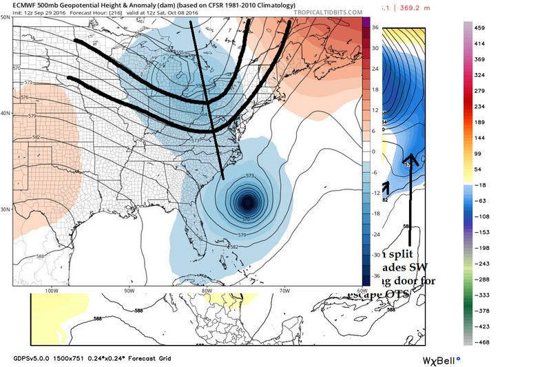
Jman that's a neutral to slightly positive tilted trough on the GFS it would push Matthew out to sea. The trough needs to be negative to pull him back. all the guidance today has the trough lifting North into Canada, weakening or staying positive. Can this change absolutely but the trends were not good today 4 landfall on East Coast hurricanejmanley32 wrote:Did you guys see how close matthew was to a capture though before going OTS, Why is the ridge on the GFS and not so much the Euro. Disagreement on that is a big deal.
algae888- Advanced Forecaster
- Posts : 5311
Reputation : 46
Join date : 2013-02-05
Age : 61
Location : mt. vernon, new york
Re: HURRICANE MATTHEW
![]() by algae888 Thu Sep 29, 2016 3:59 pm
by algae888 Thu Sep 29, 2016 3:59 pm
When I say peril I mean the time emotions and energy invested in tracking this storm. More than likely it will be a big let-down it usually is post 7 day operational runs in all seasons. I know this very well ive been there many times.jmanley32 wrote:My peril? Fine I will not put my nuts in the basket for any model then because we really still do not know, a few runs is not a trend, that has been said here before especially this far out.algae888 wrote: models coming in agreement now that Matthew will head out to sea. Cmc euro and ukie gefs. If anyone wants to believe the GFS operational do so at your own peril
algae888- Advanced Forecaster
- Posts : 5311
Reputation : 46
Join date : 2013-02-05
Age : 61
Location : mt. vernon, new york
jmanley32- Senior Enthusiast
- Posts : 20513
Reputation : 108
Join date : 2013-12-12
Age : 42
Location : Yonkers, NY
Re: HURRICANE MATTHEW
![]() by jmanley32 Thu Sep 29, 2016 4:16 pm
by jmanley32 Thu Sep 29, 2016 4:16 pm
your right, goes to show u do not listen to non-pros got this from another forum. I lurk you guys are the only ones I talk to and a chat that is full of a lot of BS.algae888 wrote:Jman that's a neutral to slightly positive tilted trough on the GFS it would push Matthew out to sea. The trough needs to be negative to pull him back. all the guidance today has the trough lifting North into Canada, weakening or staying positive. Can this change absolutely but the trends were not good today 4 landfall on East Coast hurricanejmanley32 wrote:Did you guys see how close matthew was to a capture though before going OTS, Why is the ridge on the GFS and not so much the Euro. Disagreement on that is a big deal.
jmanley32- Senior Enthusiast
- Posts : 20513
Reputation : 108
Join date : 2013-12-12
Age : 42
Location : Yonkers, NY
Re: HURRICANE MATTHEW
![]() by sroc4 Thu Sep 29, 2016 4:17 pm
by sroc4 Thu Sep 29, 2016 4:17 pm
algae888 wrote:Jman that's a neutral to slightly positive tilted trough on the GFS it would push Matthew out to sea. The trough needs to be negative to pull him back. all the guidance today has the trough lifting North into Canada, weakening or staying positive. Can this change absolutely but the trends were not good today 4 landfall on East Coast hurricanejmanley32 wrote:Did you guys see how close matthew was to a capture though before going OTS, Why is the ridge on the GFS and not so much the Euro. Disagreement on that is a big deal.
This looks more netral to neg to me Al. And honestly right now the long term track right now is more dependent on the happenings of the deep layer trough currently in the east and the ridging complex to the N of the system and in the Atlantic than the approaching trough. The euro has actually trended more favorable since yetserday in that regards. The DLT is actually further N and east just SE of maine vs off the NC coast yetserday at 12z because the Atlantic ridge is fighting back. The system is also located further west today vs yesterday and is faster in gaining latitutde. Likely because of the increase in intensity of Matt today vs where it had it by this time today yesterday. In addition The trough in the west is actually deeper than yesterday at 12z but maybe a bit faster. IMO there are trends on both GFS and Euro that still has me very concerned with an EC landfall. Im not calling anything right now because it could all trend 500miles one way or the other still.


_________________
"In weather and in life, there's no winning and losing; there's only winning and learning."
WINTER 2012/2013 TOTALS 43.65"WINTER 2017/2018 TOTALS 62.85" WINTER 2022/2023 TOTALS 4.9"
WINTER 2013/2014 TOTALS 64.85"WINTER 2018/2019 TOTALS 14.25" WINTER 2023/2024 TOTALS 13.1"
WINTER 2014/2015 TOTALS 71.20"WINTER 2019/2020 TOTALS 6.35"
WINTER 2015/2016 TOTALS 35.00"WINTER 2020/2021 TOTALS 37.75"
WINTER 2016/2017 TOTALS 42.25"WINTER 2021/2022 TOTALS 31.65"

sroc4- Admin

- Posts : 8331
Reputation : 301
Join date : 2013-01-07
Location : Wading River, LI
Re: HURRICANE MATTHEW
![]() by Quietace Thu Sep 29, 2016 4:18 pm
by Quietace Thu Sep 29, 2016 4:18 pm
I am going to advise again to not set anything in stone. Pattern evolution is still occurring, as we have already seen in the past 24 hours or so. These solutions may not exist in another 24 hours as pieces adjust past day 5.jmanley32 wrote:your right, goes to show u do not listen to non-pros got this from another forum. I lurk you guys are the only ones I talk to and a chat that is full of a lot of BS.algae888 wrote:Jman that's a neutral to slightly positive tilted trough on the GFS it would push Matthew out to sea. The trough needs to be negative to pull him back. all the guidance today has the trough lifting North into Canada, weakening or staying positive. Can this change absolutely but the trends were not good today 4 landfall on East Coast hurricanejmanley32 wrote:Did you guys see how close matthew was to a capture though before going OTS, Why is the ridge on the GFS and not so much the Euro. Disagreement on that is a big deal.
Last edited by Quietace on Thu Sep 29, 2016 4:18 pm; edited 1 time in total

Quietace- Meteorologist - Mod

- Posts : 3687
Reputation : 33
Join date : 2013-01-07
Age : 27
Location : Point Pleasant, NJ
Re: HURRICANE MATTHEW
![]() by hyde345 Thu Sep 29, 2016 4:18 pm
by hyde345 Thu Sep 29, 2016 4:18 pm
algae888 wrote: models coming in agreement now that Matthew will head out to sea. Cmc euro and ukie gefs. If anyone wants to believe the GFS operational do so at your own peril
I agree. OTS is the most likely scenario although not guaranteed this far out. I bet the 18z GFS backs away from a land falling hurricane.

hyde345- Pro Enthusiast

- Posts : 1082
Reputation : 48
Join date : 2013-01-08
Location : Hyde Park, NY
Re: HURRICANE MATTHEW
![]() by sroc4 Thu Sep 29, 2016 4:19 pm
by sroc4 Thu Sep 29, 2016 4:19 pm
_________________
"In weather and in life, there's no winning and losing; there's only winning and learning."
WINTER 2012/2013 TOTALS 43.65"WINTER 2017/2018 TOTALS 62.85" WINTER 2022/2023 TOTALS 4.9"
WINTER 2013/2014 TOTALS 64.85"WINTER 2018/2019 TOTALS 14.25" WINTER 2023/2024 TOTALS 13.1"
WINTER 2014/2015 TOTALS 71.20"WINTER 2019/2020 TOTALS 6.35"
WINTER 2015/2016 TOTALS 35.00"WINTER 2020/2021 TOTALS 37.75"
WINTER 2016/2017 TOTALS 42.25"WINTER 2021/2022 TOTALS 31.65"
sroc4- Admin
- Posts : 8331
Reputation : 301
Join date : 2013-01-07
Location : Wading River, LI
Re: HURRICANE MATTHEW
![]() by jmanley32 Thu Sep 29, 2016 4:22 pm
by jmanley32 Thu Sep 29, 2016 4:22 pm
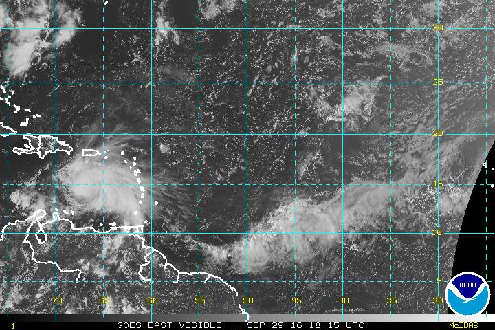
http://www.ssd.noaa.gov/PS/TROP/floaters/14L/html5-vis-short.html
jmanley32- Senior Enthusiast
- Posts : 20513
Reputation : 108
Join date : 2013-12-12
Age : 42
Location : Yonkers, NY
Re: HURRICANE MATTHEW
![]() by sroc4 Thu Sep 29, 2016 4:48 pm
by sroc4 Thu Sep 29, 2016 4:48 pm

_________________
"In weather and in life, there's no winning and losing; there's only winning and learning."
WINTER 2012/2013 TOTALS 43.65"WINTER 2017/2018 TOTALS 62.85" WINTER 2022/2023 TOTALS 4.9"
WINTER 2013/2014 TOTALS 64.85"WINTER 2018/2019 TOTALS 14.25" WINTER 2023/2024 TOTALS 13.1"
WINTER 2014/2015 TOTALS 71.20"WINTER 2019/2020 TOTALS 6.35"
WINTER 2015/2016 TOTALS 35.00"WINTER 2020/2021 TOTALS 37.75"
WINTER 2016/2017 TOTALS 42.25"WINTER 2021/2022 TOTALS 31.65"
sroc4- Admin
- Posts : 8331
Reputation : 301
Join date : 2013-01-07
Location : Wading River, LI
Re: HURRICANE MATTHEW
![]() by jmanley32 Thu Sep 29, 2016 4:52 pm
by jmanley32 Thu Sep 29, 2016 4:52 pm
so does that tell us anything? Msybe euro go even more west. If it does it will make landfall in fl or se if similar track to 12z but more west. When do u think u will start to become more certain or is that even too hard to tell now?sroc4 wrote:Ensembles are still west of Operationals.
jmanley32- Senior Enthusiast
- Posts : 20513
Reputation : 108
Join date : 2013-12-12
Age : 42
Location : Yonkers, NY
Page 15 of 32 • 1 ... 9 ... 14, 15, 16 ... 23 ... 32 ![]()
|
|
|