
 Search
HURRICANE MATTHEW: Phase 2--"The Turn"
Page 32 of 40 •  1 ... 17 ... 31, 32, 33 ... 36 ... 40
 ![]()
Re: HURRICANE MATTHEW: Phase 2--"The Turn"
![]() by jmanley32 Mon Oct 03, 2016 2:55 pm
by jmanley32 Mon Oct 03, 2016 2:55 pm
jmanley32- Senior Enthusiast

- Posts : 20516
Join date : 2013-12-12
Re: HURRICANE MATTHEW: Phase 2--"The Turn"
![]() by Sanchize06 Mon Oct 03, 2016 2:58 pm
by Sanchize06 Mon Oct 03, 2016 2:58 pm
jmanley32 wrote:holy crap! That's pretty dead on for a hit! Huge shift. Wow. Very much like irene but could b stronger depending on intensity and land interaction. These aRe huge changes today.Sanchize06 wrote:

Yeah haha pretty much everything came west. Maybe the more frequent balloon launches are giving the models a better idea of how the upper levels are going to play out, like the stronger Atlantic Ridge we've seen today from all models
Sanchize06- Senior Enthusiast
- Posts : 1041
Join date : 2013-02-05
Re: HURRICANE MATTHEW: Phase 2--"The Turn"
![]() by jmanley32 Mon Oct 03, 2016 3:04 pm
by jmanley32 Mon Oct 03, 2016 3:04 pm

jmanley32- Senior Enthusiast
- Posts : 20516
Reputation : 108
Join date : 2013-12-12
Age : 42
Location : Yonkers, NY
Re: HURRICANE MATTHEW: Phase 2--"The Turn"
![]() by Frank_Wx Mon Oct 03, 2016 3:07 pm
by Frank_Wx Mon Oct 03, 2016 3:07 pm

_________________
_______________________________________________________________________________________________________
CLICK HERE to view NJ Strong Snowstorm Classifications

Frank_Wx- Godzilla Seeker

- Posts : 21305
Reputation : 328
Join date : 2013-01-05
Age : 31
Location : Jersey City, NJ -

Re: HURRICANE MATTHEW: Phase 2--"The Turn"
![]() by hyde345 Mon Oct 03, 2016 3:08 pm
by hyde345 Mon Oct 03, 2016 3:08 pm
Sanchize06 wrote:
This says it all. The euro is pretty much on its own.

hyde345- Pro Enthusiast

- Posts : 1082
Reputation : 48
Join date : 2013-01-08
Location : Hyde Park, NY
Re: HURRICANE MATTHEW: Phase 2--"The Turn"
![]() by Frank_Wx Mon Oct 03, 2016 3:09 pm
by Frank_Wx Mon Oct 03, 2016 3:09 pm
jmanley32 wrote:I think one more day and we can start to turn volume up on the alarm a bit. What ur thoughts frank threat increased a lot?
In my Mo Mo I was leaning Euro. After this afternoon, I am leaning GFS. If you see the banner change to Storm Mode, that is when you know I am confident on impacts to our area.
_________________
_______________________________________________________________________________________________________
CLICK HERE to view NJ Strong Snowstorm Classifications
Frank_Wx- Godzilla Seeker
- Posts : 21305
Reputation : 328
Join date : 2013-01-05
Age : 31
Location : Jersey City, NJ -
Re: HURRICANE MATTHEW: Phase 2--"The Turn"
![]() by aiannone Mon Oct 03, 2016 3:09 pm
by aiannone Mon Oct 03, 2016 3:09 pm
_________________
-Alex Iannone-

aiannone- Senior Enthusiast - Mod

- Posts : 4814
Reputation : 92
Join date : 2013-01-07
Location : Saint James, LI (Northwest Suffolk Co.)
Re: HURRICANE MATTHEW: Phase 2--"The Turn"
![]() by Frank_Wx Mon Oct 03, 2016 3:10 pm
by Frank_Wx Mon Oct 03, 2016 3:10 pm
aiannone wrote:This is just great. Had a 4 day weekend this weekend and now we get a possible hurricane next weekend on a Sunday when I have classes Monday. Maybe it will be enough to close Binghamton and I can come home haha. I drove all the way home for Hermine and you know how that ended lol.
Yes we do. Stay in Binghamton. If you come home, I'll ban you.
_________________
_______________________________________________________________________________________________________
CLICK HERE to view NJ Strong Snowstorm Classifications
Frank_Wx- Godzilla Seeker
- Posts : 21305
Reputation : 328
Join date : 2013-01-05
Age : 31
Location : Jersey City, NJ -
Re: HURRICANE MATTHEW: Phase 2--"The Turn"
![]() by sroc4 Mon Oct 03, 2016 3:10 pm
by sroc4 Mon Oct 03, 2016 3:10 pm
aiannone wrote:This is just great. Had a 4 day weekend this weekend and now we get a possible hurricane next weekend on a Sunday when I have classes Monday. Maybe it will be enough to close Binghamton and I can come home haha. I drove all the way home for Hermine and you know how that ended lol.
So stay where you are so you dont jinx it Alex
_________________
"In weather and in life, there's no winning and losing; there's only winning and learning."
WINTER 2012/2013 TOTALS 43.65"WINTER 2017/2018 TOTALS 62.85" WINTER 2022/2023 TOTALS 4.9"
WINTER 2013/2014 TOTALS 64.85"WINTER 2018/2019 TOTALS 14.25" WINTER 2023/2024 TOTALS 13.1"
WINTER 2014/2015 TOTALS 71.20"WINTER 2019/2020 TOTALS 6.35"
WINTER 2015/2016 TOTALS 35.00"WINTER 2020/2021 TOTALS 37.75"
WINTER 2016/2017 TOTALS 42.25"WINTER 2021/2022 TOTALS 31.65"

sroc4- Admin
- Posts : 8331
Reputation : 301
Join date : 2013-01-07
Location : Wading River, LI
Re: HURRICANE MATTHEW: Phase 2--"The Turn"
![]() by Frank_Wx Mon Oct 03, 2016 3:11 pm
by Frank_Wx Mon Oct 03, 2016 3:11 pm

_________________
_______________________________________________________________________________________________________
CLICK HERE to view NJ Strong Snowstorm Classifications
Frank_Wx- Godzilla Seeker
- Posts : 21305
Reputation : 328
Join date : 2013-01-05
Age : 31
Location : Jersey City, NJ -
Re: HURRICANE MATTHEW: Phase 2--"The Turn"
![]() by aiannone Mon Oct 03, 2016 3:15 pm
by aiannone Mon Oct 03, 2016 3:15 pm
Frank_Wx wrote:aiannone wrote:This is just great. Had a 4 day weekend this weekend and now we get a possible hurricane next weekend on a Sunday when I have classes Monday. Maybe it will be enough to close Binghamton and I can come home haha. I drove all the way home for Hermine and you know how that ended lol.
Yes we do. Stay in Binghamton. If you come home, I'll ban you.
If Binghamton Closes, I'm coming whether you like it or not haha
_________________
-Alex Iannone-
aiannone- Senior Enthusiast - Mod
- Posts : 4814
Reputation : 92
Join date : 2013-01-07
Location : Saint James, LI (Northwest Suffolk Co.)
Re: HURRICANE MATTHEW: Phase 2--"The Turn"
![]() by jmanley32 Mon Oct 03, 2016 3:15 pm
by jmanley32 Mon Oct 03, 2016 3:15 pm
jmanley32- Senior Enthusiast
- Posts : 20516
Reputation : 108
Join date : 2013-12-12
Age : 42
Location : Yonkers, NY
Re: HURRICANE MATTHEW: Phase 2--"The Turn"
![]() by jmanley32 Mon Oct 03, 2016 3:16 pm
by jmanley32 Mon Oct 03, 2016 3:16 pm
I feel ya I'd want to come down too.aiannone wrote:Frank_Wx wrote:aiannone wrote:This is just great. Had a 4 day weekend this weekend and now we get a possible hurricane next weekend on a Sunday when I have classes Monday. Maybe it will be enough to close Binghamton and I can come home haha. I drove all the way home for Hermine and you know how that ended lol.
Yes we do. Stay in Binghamton. If you come home, I'll ban you.
If Binghamton Closes, I'm coming whether you like it or not haha
jmanley32- Senior Enthusiast
- Posts : 20516
Reputation : 108
Join date : 2013-12-12
Age : 42
Location : Yonkers, NY
Re: HURRICANE MATTHEW: Phase 2--"The Turn"
![]() by aiannone Mon Oct 03, 2016 3:17 pm
by aiannone Mon Oct 03, 2016 3:17 pm
Close Up
_________________
-Alex Iannone-
aiannone- Senior Enthusiast - Mod
- Posts : 4814
Reputation : 92
Join date : 2013-01-07
Location : Saint James, LI (Northwest Suffolk Co.)
Re: HURRICANE MATTHEW: Phase 2--"The Turn"
![]() by jmanley32 Mon Oct 03, 2016 3:17 pm
by jmanley32 Mon Oct 03, 2016 3:17 pm
jmanley32- Senior Enthusiast
- Posts : 20516
Reputation : 108
Join date : 2013-12-12
Age : 42
Location : Yonkers, NY
Re: HURRICANE MATTHEW: Phase 2--"The Turn"
![]() by rb924119 Mon Oct 03, 2016 3:18 pm
by rb924119 Mon Oct 03, 2016 3:18 pm
rb924119- Meteorologist

- Posts : 6890
Reputation : 194
Join date : 2013-02-06
Age : 32
Location : Greentown, Pa
Re: HURRICANE MATTHEW: Phase 2--"The Turn"
![]() by njwx7 Mon Oct 03, 2016 3:18 pm
by njwx7 Mon Oct 03, 2016 3:18 pm
njwx7- Posts : 5
Reputation : 0
Join date : 2016-10-02
Re: HURRICANE MATTHEW: Phase 2--"The Turn"
![]() by billg315 Mon Oct 03, 2016 3:19 pm
by billg315 Mon Oct 03, 2016 3:19 pm

billg315- Advanced Forecaster - Mod
- Posts : 4468
Reputation : 185
Join date : 2015-01-24
Age : 50
Location : Flemington, NJ
Re: HURRICANE MATTHEW: Phase 2--"The Turn"
![]() by Frank_Wx Mon Oct 03, 2016 3:24 pm
by Frank_Wx Mon Oct 03, 2016 3:24 pm
rb924119 wrote:In my opinion, the key or keys, to this whole thing, actually lie in the eastern and northern Pacific. At work so I can't really do a full write up, but take notice of the drastic differences at H5 between the EURO and the GFS in these regions. The GFS depicts an important phase beneath the Alaskan ridge, which not only continues the look of a -EPO, but also develops an ideal Gulf of Alaska low. These allow the PNA region to spike at the perfect time and maintain a deep enough trough to capture Matthew. The EURO on the other hand, does not take part in the phase and allows the two shortwaves to remain distinct and separate entities. This prevents the -EPO and Gulf of Alaska low from developing, and maintains the progressive pattern. Which am I favoring? ABSOLUTELY NO IDEA. What am I worried about? Well, the EURO has been the most consistent with respect to its evolution and timing, although seemingly not so now. The GFS hasn't, for one, and secondly, we all know what the GFS likes to do in the colder times of the year-bombard the Eastern US with troughs and cold weather. Could this be part of the problem and reason why we are seeing the current solution come back? Possibly. Definitely? No. Moral to the story: Find a real short pier and take a nice long walk......

_________________
_______________________________________________________________________________________________________
CLICK HERE to view NJ Strong Snowstorm Classifications
Frank_Wx- Godzilla Seeker
- Posts : 21305
Reputation : 328
Join date : 2013-01-05
Age : 31
Location : Jersey City, NJ -
Re: HURRICANE MATTHEW: Phase 2--"The Turn"
![]() by RJB8525 Mon Oct 03, 2016 3:25 pm
by RJB8525 Mon Oct 03, 2016 3:25 pm

RJB8525- Senior Enthusiast
- Posts : 1994
Reputation : 28
Join date : 2013-02-06
Age : 38
Location : Hackettstown, NJ
Re: HURRICANE MATTHEW: Phase 2--"The Turn"
![]() by Frank_Wx Mon Oct 03, 2016 3:27 pm
by Frank_Wx Mon Oct 03, 2016 3:27 pm
Well contrary to what some have said, the Euro has so far been by far the best performing model for this storm...the numbers say it. But also told me just a bit ago if he sees the trough in the midwest trend stronger he can definitely see it come up past hatteras...But right now he likes the euro solution still...I think its plausible. not sure if i agree with him entirely
_________________
_______________________________________________________________________________________________________
CLICK HERE to view NJ Strong Snowstorm Classifications
Frank_Wx- Godzilla Seeker
- Posts : 21305
Reputation : 328
Join date : 2013-01-05
Age : 31
Location : Jersey City, NJ -
Re: HURRICANE MATTHEW: Phase 2--"The Turn"
![]() by sroc4 Mon Oct 03, 2016 3:30 pm
by sroc4 Mon Oct 03, 2016 3:30 pm
rb924119 wrote:In my opinion, the key or keys, to this whole thing, actually lie in the eastern and northern Pacific. At work so I can't really do a full write up, but take notice of the drastic differences at H5 between the EURO and the GFS in these regions. The GFS depicts an important phase beneath the Alaskan ridge, which not only continues the look of a -EPO, but also develops an ideal Gulf of Alaska low. These allow the PNA region to spike at the perfect time and maintain a deep enough trough to capture Matthew. The EURO on the other hand, does not take part in the phase and allows the two shortwaves to remain distinct and separate entities. This prevents the -EPO and Gulf of Alaska low from developing, and maintains the progressive pattern. Which am I favoring? ABSOLUTELY NO IDEA. What am I worried about? Well, the EURO has been the most consistent with respect to its evolution and timing, although seemingly not so now. The GFS hasn't, for one, and secondly, we all know what the GFS likes to do in the colder times of the year-bombard the Eastern US with troughs and cold weather. Could this be part of the problem and reason why we are seeing the current solution come back? Possibly. Definitely? No. Moral to the story: Find a real short pier and take a nice long walk......
Yup! I plan on trying to outline exactly what your saying with maps in the morning. Up through now there have been too many other hurdles. But it is now time to look to the west.
_________________
"In weather and in life, there's no winning and losing; there's only winning and learning."
WINTER 2012/2013 TOTALS 43.65"WINTER 2017/2018 TOTALS 62.85" WINTER 2022/2023 TOTALS 4.9"
WINTER 2013/2014 TOTALS 64.85"WINTER 2018/2019 TOTALS 14.25" WINTER 2023/2024 TOTALS 13.1"
WINTER 2014/2015 TOTALS 71.20"WINTER 2019/2020 TOTALS 6.35"
WINTER 2015/2016 TOTALS 35.00"WINTER 2020/2021 TOTALS 37.75"
WINTER 2016/2017 TOTALS 42.25"WINTER 2021/2022 TOTALS 31.65"
sroc4- Admin
- Posts : 8331
Reputation : 301
Join date : 2013-01-07
Location : Wading River, LI
Re: HURRICANE MATTHEW: Phase 2--"The Turn"
![]() by Dis2cruise Mon Oct 03, 2016 3:33 pm
by Dis2cruise Mon Oct 03, 2016 3:33 pm
Dis2cruise- Posts : 20
Reputation : 0
Join date : 2013-11-08
Re: HURRICANE MATTHEW: Phase 2--"The Turn"
![]() by Frank_Wx Mon Oct 03, 2016 3:39 pm
by Frank_Wx Mon Oct 03, 2016 3:39 pm
Dis2cruise wrote:Approx. what day would this be hitting LI ?
IF he hits LI, a very big IF, it is likely to be late Saturday into Sunday. Or early Sunday into Monday. Timing is uncertain. Among many other things.
_________________
_______________________________________________________________________________________________________
CLICK HERE to view NJ Strong Snowstorm Classifications
Frank_Wx- Godzilla Seeker
- Posts : 21305
Reputation : 328
Join date : 2013-01-05
Age : 31
Location : Jersey City, NJ -
Re: HURRICANE MATTHEW: Phase 2--"The Turn"
![]() by Frank_Wx Mon Oct 03, 2016 3:42 pm
by Frank_Wx Mon Oct 03, 2016 3:42 pm
_________________
_______________________________________________________________________________________________________
CLICK HERE to view NJ Strong Snowstorm Classifications
Frank_Wx- Godzilla Seeker
- Posts : 21305
Reputation : 328
Join date : 2013-01-05
Age : 31
Location : Jersey City, NJ -
Re: HURRICANE MATTHEW: Phase 2--"The Turn"
![]() by Dis2cruise Mon Oct 03, 2016 3:45 pm
by Dis2cruise Mon Oct 03, 2016 3:45 pm
Frank_Wx wrote:Dis2cruise wrote:Approx. what day would this be hitting LI ?
IF he hits LI, a very big IF, it is likely to be late Saturday into Sunday. Or early Sunday into Monday. Timing is uncertain. Among many other things.
Thanks so much heading to fire island this weekend.....maybe not ugh
Dis2cruise- Posts : 20
Reputation : 0
Join date : 2013-11-08
Re: HURRICANE MATTHEW: Phase 2--"The Turn"
![]() by Frank_Wx Mon Oct 03, 2016 3:46 pm
by Frank_Wx Mon Oct 03, 2016 3:46 pm

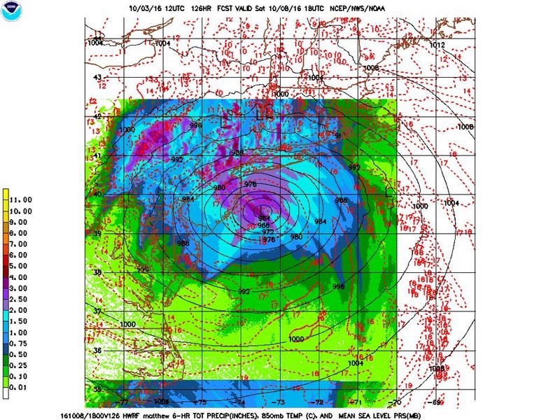
12z for comparison:

_________________
_______________________________________________________________________________________________________
CLICK HERE to view NJ Strong Snowstorm Classifications
Frank_Wx- Godzilla Seeker
- Posts : 21305
Reputation : 328
Join date : 2013-01-05
Age : 31
Location : Jersey City, NJ -
Page 32 of 40 • 1 ... 17 ... 31, 32, 33 ... 36 ... 40 ![]()
|
|
|