
 Search
Long Range Thread 13.0
Page 25 of 40 •  1 ... 14 ... 24, 25, 26 ... 32 ... 40
 ![]()
Re: Long Range Thread 13.0
![]() by Frank_Wx Tue Jan 10, 2017 7:37 pm
by Frank_Wx Tue Jan 10, 2017 7:37 pm
Frank_Wx- Godzilla Seeker

- Posts : 21305
Join date : 2013-01-05 -

Re: Long Range Thread 13.0
![]() by billg315 Tue Jan 10, 2017 8:04 pm
by billg315 Tue Jan 10, 2017 8:04 pm
Frank_Wx wrote:Wow, check out this upper level jet extension taking shape in the Pacific over the next 7 days. Safe to say the drought in California will come to an end. The EPO/PNA will not be in our favor either.
Day 1
Day 3
Day 7
Day 8


And as usual with California, if the droughts ending, they'll have mudslides and flooding. There seems to be no in between in that state.
billg315- Advanced Forecaster - Mod

- Posts : 4469
Join date : 2015-01-24
Re: Long Range Thread 13.0
![]() by Frank_Wx Tue Jan 10, 2017 8:08 pm
by Frank_Wx Tue Jan 10, 2017 8:08 pm
Pass.
_________________
_______________________________________________________________________________________________________
CLICK HERE to view NJ Strong Snowstorm Classifications

Frank_Wx- Godzilla Seeker
- Posts : 21305
Reputation : 328
Join date : 2013-01-05
Age : 31
Location : Jersey City, NJ -
Re: Long Range Thread 13.0
![]() by billg315 Tue Jan 10, 2017 8:22 pm
by billg315 Tue Jan 10, 2017 8:22 pm

billg315- Advanced Forecaster - Mod
- Posts : 4469
Reputation : 185
Join date : 2015-01-24
Age : 50
Location : Flemington, NJ
Re: Long Range Thread 13.0
![]() by frank 638 Tue Jan 10, 2017 8:49 pm
by frank 638 Tue Jan 10, 2017 8:49 pm
frank 638- Senior Enthusiast

- Posts : 2825
Reputation : 37
Join date : 2016-01-01
Age : 40
Location : bronx ny
Re: Long Range Thread 13.0
![]() by Frank_Wx Tue Jan 10, 2017 9:21 pm
by Frank_Wx Tue Jan 10, 2017 9:21 pm

_________________
_______________________________________________________________________________________________________
CLICK HERE to view NJ Strong Snowstorm Classifications
Frank_Wx- Godzilla Seeker
- Posts : 21305
Reputation : 328
Join date : 2013-01-05
Age : 31
Location : Jersey City, NJ -
Re: Long Range Thread 13.0
![]() by rb924119 Tue Jan 10, 2017 10:47 pm
by rb924119 Tue Jan 10, 2017 10:47 pm
rb924119- Meteorologist

- Posts : 6890
Reputation : 194
Join date : 2013-02-06
Age : 32
Location : Greentown, Pa
Re: Long Range Thread 13.0
![]() by rb924119 Tue Jan 10, 2017 11:39 pm
by rb924119 Tue Jan 10, 2017 11:39 pm
rb924119- Meteorologist
- Posts : 6890
Reputation : 194
Join date : 2013-02-06
Age : 32
Location : Greentown, Pa
Re: Long Range Thread 13.0
![]() by Frank_Wx Wed Jan 11, 2017 6:00 am
by Frank_Wx Wed Jan 11, 2017 6:00 am
_________________
_______________________________________________________________________________________________________
CLICK HERE to view NJ Strong Snowstorm Classifications
Frank_Wx- Godzilla Seeker
- Posts : 21305
Reputation : 328
Join date : 2013-01-05
Age : 31
Location : Jersey City, NJ -
Re: Long Range Thread 13.0
![]() by rb924119 Wed Jan 11, 2017 9:25 am
by rb924119 Wed Jan 11, 2017 9:25 am
Frank_Wx wrote:I'm not excited for next week. Country looks devoid of cold air.
Thanks for crushing all of my hopes and dreams. Time for me to crawl in a corner and cry myself to sleep
rb924119- Meteorologist
- Posts : 6890
Reputation : 194
Join date : 2013-02-06
Age : 32
Location : Greentown, Pa
Re: Long Range Thread 13.0
![]() by HectorO Wed Jan 11, 2017 9:49 am
by HectorO Wed Jan 11, 2017 9:49 am
billg315 wrote:Frank_Wx wrote:Wow, check out this upper level jet extension taking shape in the Pacific over the next 7 days. Safe to say the drought in California will come to an end. The EPO/PNA will not be in our favor either.
Day 1
Day 3
Day 7
Day 8
And as usual with California, if the droughts ending, they'll have mudslides and flooding. There seems to be no in between in that state.
That's a huge state. If I had the money to pick up and go I would get a cabin in Lake Tahoe.

HectorO- Pro Enthusiast

- Posts : 959
Reputation : 27
Join date : 2013-01-11
Re: Long Range Thread 13.0
![]() by Frank_Wx Wed Jan 11, 2017 9:57 am
by Frank_Wx Wed Jan 11, 2017 9:57 am
The EPO/WPO will shoot to +3 SD in the coming days. The location of the Pacific Jet extension across the northern Pacific will track cyclones into the WPO/EPO domains. Further, the intensity of these cyclones will keep heights well below normal hence the dramatic look of the +EPO by the ECM. As the western U.S. experiences unsettled and cooler than normal weather, the east will see milder temperatures and frequent rain events during this time period.


EPS Day 5 to 10 850mb temp anomaly average

EPS Day 9 to 14 850mb temp anomaly average

The Canadian warmth, shown best at H5 by the Hudson Bay "block," will remove arctic air from much of central and eastern North America. This block will eventually deteriorate or move into the higher latitudes near the AO/NAO domains. Again, I think that happens either the last couple of days of January or early February.
Enjoy the 40's and 50's
_________________
_______________________________________________________________________________________________________
CLICK HERE to view NJ Strong Snowstorm Classifications
Frank_Wx- Godzilla Seeker
- Posts : 21305
Reputation : 328
Join date : 2013-01-05
Age : 31
Location : Jersey City, NJ -
Re: Long Range Thread 13.0
![]() by weatherwatchermom Wed Jan 11, 2017 10:09 am
by weatherwatchermom Wed Jan 11, 2017 10:09 am
Oymyakon will also have a warm up according to weaather.com and accuweather....going from almost 50 below to 20 below zero

weatherwatchermom- Senior Enthusiast
- Posts : 3750
Reputation : 77
Join date : 2014-11-25
Age : 60
Location : Hazlet Township, NJ
Re: Long Range Thread 13.0
![]() by HectorO Wed Jan 11, 2017 10:51 am
by HectorO Wed Jan 11, 2017 10:51 am
weatherwatchermom wrote:https://weather.com/weather/tenday/l/RSXX5470:1:RS
Oymyakon will also have a warm up according to weaather.com and accuweather....going from almost 50 below to 20 below zero
You're obsessed with this place lol
HectorO- Pro Enthusiast
- Posts : 959
Reputation : 27
Join date : 2013-01-11
Re: Long Range Thread 13.0
![]() by rb924119 Wed Jan 11, 2017 3:22 pm
by rb924119 Wed Jan 11, 2017 3:22 pm
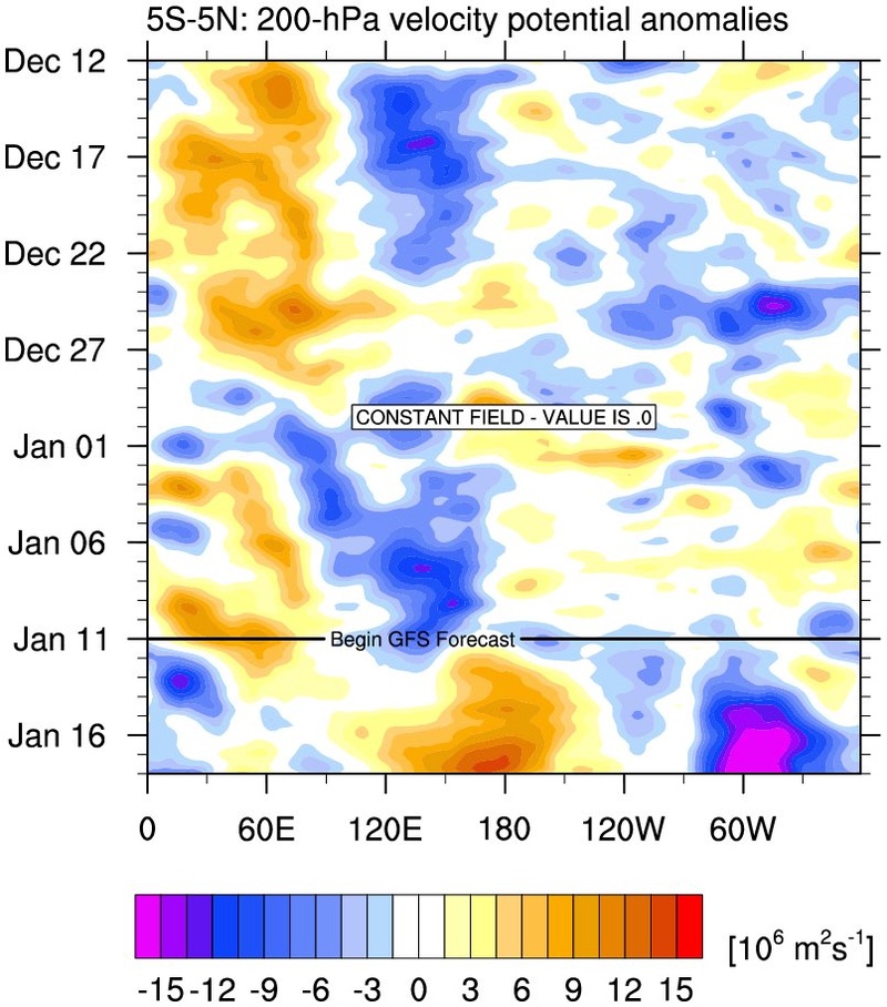
http://www.weatherbell.com/premium/joe-bastardi/mjo-plot-continues-to-thicken
rb924119- Meteorologist
- Posts : 6890
Reputation : 194
Join date : 2013-02-06
Age : 32
Location : Greentown, Pa
Re: Long Range Thread 13.0
![]() by sroc4 Wed Jan 11, 2017 4:23 pm
by sroc4 Wed Jan 11, 2017 4:23 pm
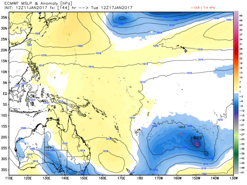
rb924119 wrote:Glad to see there's at least some support for the ideas discussed yesterday may have a little merit:
http://www.weatherbell.com/premium/joe-bastardi/mjo-plot-continues-to-thicken
Im with you on thi9s one Ray. Certainly not lock stock and barrel given the way the 5-7days and beyond MJO forecasts have verified. The one thing I will bring back up is the SOI. Look at where we are now with lower pressures still over Darwin. Tahiti is starrting to show lower pressures, so this is why the latest SOI has come down to around 8.7 instead of in the high teens and twenties like the last week or so.
https://www.longpaddock.qld.gov.au/seasonalclimateoutlook/southernoscillationindex/30daysoivalues/
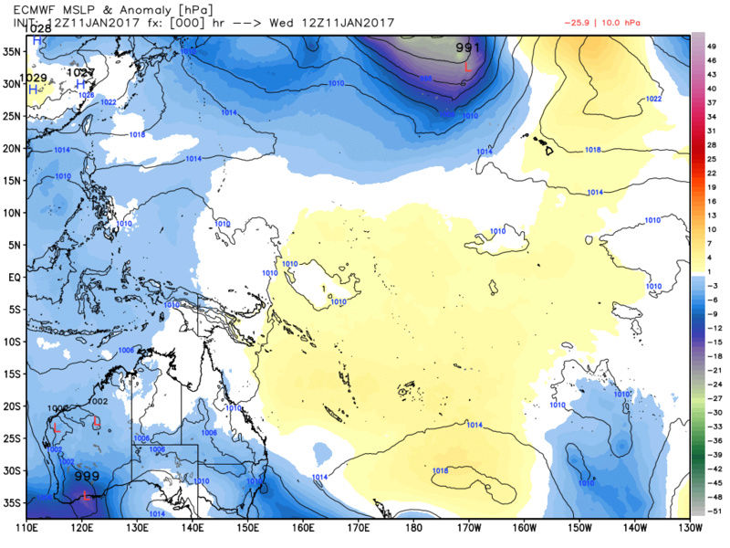
But look at the flip by day three. Pressures are building into the west and pressures cont to be low in the east. This cont through out the run. So expect the SOI to drop. If it drops significantly enough for long enough to quote JB it should introduce "the cattle prod" to the system. We shall see if its enough to significantly alter things but these maps support the MJO forecast. The modeling over the NA continent will begin to shift as a wave break to the firehose that is the Pac jet should occur....IF we get a significant enough drop to the SOI. This would/should begin to shift the trop forcings from a La Nina like pattern to an el nino like pattern. Likely what Tom (isotherm) discussed with regards to a shift in the walker cell config.


_________________
"In weather and in life, there's no winning and losing; there's only winning and learning."
WINTER 2012/2013 TOTALS 43.65"WINTER 2017/2018 TOTALS 62.85" WINTER 2022/2023 TOTALS 4.9"
WINTER 2013/2014 TOTALS 64.85"WINTER 2018/2019 TOTALS 14.25" WINTER 2023/2024 TOTALS 13.1"
WINTER 2014/2015 TOTALS 71.20"WINTER 2019/2020 TOTALS 6.35"
WINTER 2015/2016 TOTALS 35.00"WINTER 2020/2021 TOTALS 37.75"
WINTER 2016/2017 TOTALS 42.25"WINTER 2021/2022 TOTALS 31.65"

sroc4- Admin
- Posts : 8331
Reputation : 301
Join date : 2013-01-07
Location : Wading River, LI
Re: Long Range Thread 13.0
![]() by weatherwatchermom Wed Jan 11, 2017 4:57 pm
by weatherwatchermom Wed Jan 11, 2017 4:57 pm
HectorO wrote:weatherwatchermom wrote:https://weather.com/weather/tenday/l/RSXX5470:1:RS
Oymyakon will also have a warm up according to weaather.com and accuweather....going from almost 50 below to 20 below zero
You're obsessed with this place lol
I know......it fascinates me how people can live in a place considered to be the coldest place on earth with no indoor plumbing...temps so extreme and the middle of no where..and exquisitely beautiful! .it is on my bucket lists of places to visit...my husband thinks I am crazy.. ps...lived in Brazil for a while so I do like warm weather places as well! I will find some other cold spot to post about...
weatherwatchermom- Senior Enthusiast
- Posts : 3750
Reputation : 77
Join date : 2014-11-25
Age : 60
Location : Hazlet Township, NJ
Re: Long Range Thread 13.0
![]() by HectorO Wed Jan 11, 2017 5:20 pm
by HectorO Wed Jan 11, 2017 5:20 pm
weatherwatchermom wrote:HectorO wrote:weatherwatchermom wrote:https://weather.com/weather/tenday/l/RSXX5470:1:RS
Oymyakon will also have a warm up according to weaather.com and accuweather....going from almost 50 below to 20 below zero
You're obsessed with this place lol
I know......it fascinates me how people can live in a place considered to be the coldest place on earth with no indoor plumbing...temps so extreme and the middle of no where..and exquisitely beautiful! .it is on my bucket lists of places to visit...my husband thinks I am crazy.. ps...lived in Brazil for a while so I do like warm weather places as well! I will find some other cold spot to post about...
Barrow Alaska imo is worse. Temp highs there may reach -20 and -30 for lows and maybe warmer, although that place in russia by temp is cold it has a summer though. Barrow doesn't. The hottest it gets there is June and it barely breaks 40s, 38 is the average summer temp. And that town in Russia is calm wind where Barrow has a constant wind blowing off the Arctic ocean which make the temps feels way worse. It's warm this week for them too. A balmy, warm -8 for a high.
HectorO- Pro Enthusiast
- Posts : 959
Reputation : 27
Join date : 2013-01-11
Re: Long Range Thread 13.0
![]() by amugs Wed Jan 11, 2017 5:22 pm
by amugs Wed Jan 11, 2017 5:22 pm
MJO looking to go 8 by these charts IF we can get this which after looking at the maps for Darwin and Tahiti we most certainly look to headed in that direction

_________________
Mugs
AKA:King: Snow Weenie
Self Proclaimed
WINTER 2014-15 : 55.12" +.02 for 6 coatings (avg. 35")
WINTER 2015-16 Total - 29.8" (Avg 35")
WINTER 2016-17 : 39.5" so far

amugs- Advanced Forecaster - Mod
- Posts : 15093
Reputation : 213
Join date : 2013-01-07
Age : 54
Location : Hillsdale,NJ
Re: Long Range Thread 13.0
![]() by frank 638 Wed Jan 11, 2017 6:01 pm
by frank 638 Wed Jan 11, 2017 6:01 pm
frank 638- Senior Enthusiast
- Posts : 2825
Reputation : 37
Join date : 2016-01-01
Age : 40
Location : bronx ny
Re: Long Range Thread 13.0
![]() by amugs Wed Jan 11, 2017 6:12 pm
by amugs Wed Jan 11, 2017 6:12 pm
frank 638 wrote:just got done watching Lonnie Quinn forecast he mentioned that we will go back to a winter pattern by late Jan into Feb he also believes that February looks to be cold and possibly snowy
LQ reading our board - he is a Ken doll disguised as a weather man.
_________________
Mugs
AKA:King: Snow Weenie
Self Proclaimed
WINTER 2014-15 : 55.12" +.02 for 6 coatings (avg. 35")
WINTER 2015-16 Total - 29.8" (Avg 35")
WINTER 2016-17 : 39.5" so far
amugs- Advanced Forecaster - Mod
- Posts : 15093
Reputation : 213
Join date : 2013-01-07
Age : 54
Location : Hillsdale,NJ
Re: Long Range Thread 13.0
![]() by rb924119 Wed Jan 11, 2017 6:37 pm
by rb924119 Wed Jan 11, 2017 6:37 pm
sroc4 wrote:rb924119 wrote:Glad to see there's at least some support for the ideas discussed yesterday may have a little merit:
http://www.weatherbell.com/premium/joe-bastardi/mjo-plot-continues-to-thicken
Im with you on thi9s one Ray. Certainly not lock stock and barrel given the way the 5-7days and beyond MJO forecasts have verified. The one thing I will bring back up is the SOI. Look at where we are now with lower pressures still over Darwin. Tahiti is starrting to show lower pressures, so this is why the latest SOI has come down to around 8.7 instead of in the high teens and twenties like the last week or so.
But look at the flip by day three. Pressures are building into the west and pressures cont to be low in the east. This cont through out the run. So expect the SOI to drop. If it drops significantly enough for long enough to quote JB it should introduce "the cattle prod" to the system. We shall see if its enough to significantly alter things but these maps support the MJO forecast. The modeling over the NA continent will begin to shift as a wave break to the firehose that is the Pac jet should occur....IF we get a significant enough drop to the SOI. This would/should begin to shift the trop forcings from a La Nina like pattern to an el nino like pattern. Likely what Tom (isotherm) discussed with regards to a shift in the walker cell config.
No, I know you are, that's why I just said "ideas" haha I'm just meant outside our discussion here on the board, that's all. At least we know we're not crazy for thinking what we are (although maybe we are and just aren't the ONLY crazy ones haha)
But nice illustration linking everything!
rb924119- Meteorologist
- Posts : 6890
Reputation : 194
Join date : 2013-02-06
Age : 32
Location : Greentown, Pa
Re: Long Range Thread 13.0
![]() by algae888 Wed Jan 11, 2017 7:02 pm
by algae888 Wed Jan 11, 2017 7:02 pm

algae888- Advanced Forecaster

- Posts : 5311
Reputation : 46
Join date : 2013-02-05
Age : 61
Location : mt. vernon, new york
Re: Long Range Thread 13.0
![]() by Armando Salvadore Wed Jan 11, 2017 8:51 pm
by Armando Salvadore Wed Jan 11, 2017 8:51 pm


Armando Salvadore- Advanced Forecaster
- Posts : 171
Reputation : 0
Join date : 2016-12-23
Location : Springfield, NJ
Re: Long Range Thread 13.0
![]() by Frank_Wx Wed Jan 11, 2017 9:15 pm
by Frank_Wx Wed Jan 11, 2017 9:15 pm

_________________
_______________________________________________________________________________________________________
CLICK HERE to view NJ Strong Snowstorm Classifications
Frank_Wx- Godzilla Seeker
- Posts : 21305
Reputation : 328
Join date : 2013-01-05
Age : 31
Location : Jersey City, NJ -
Re: Long Range Thread 13.0
![]() by Frank_Wx Wed Jan 11, 2017 9:18 pm
by Frank_Wx Wed Jan 11, 2017 9:18 pm
_________________
_______________________________________________________________________________________________________
CLICK HERE to view NJ Strong Snowstorm Classifications
Frank_Wx- Godzilla Seeker
- Posts : 21305
Reputation : 328
Join date : 2013-01-05
Age : 31
Location : Jersey City, NJ -
Re: Long Range Thread 13.0
![]() by Armando Salvadore Wed Jan 11, 2017 9:19 pm
by Armando Salvadore Wed Jan 11, 2017 9:19 pm
Armando Salvadore- Advanced Forecaster
- Posts : 171
Reputation : 0
Join date : 2016-12-23
Location : Springfield, NJ
Page 25 of 40 • 1 ... 14 ... 24, 25, 26 ... 32 ... 40 ![]()
|
|
|