
 Search
Long Range Thread 13.0
Page 31 of 40 •  1 ... 17 ... 30, 31, 32 ... 35 ... 40
 ![]()
Re: Long Range Thread 13.0
![]() by Frank_Wx Mon Jan 16, 2017 9:20 am
by Frank_Wx Mon Jan 16, 2017 9:20 am
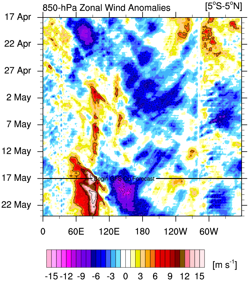
Interesting ENSO battle taking place at 200hPa
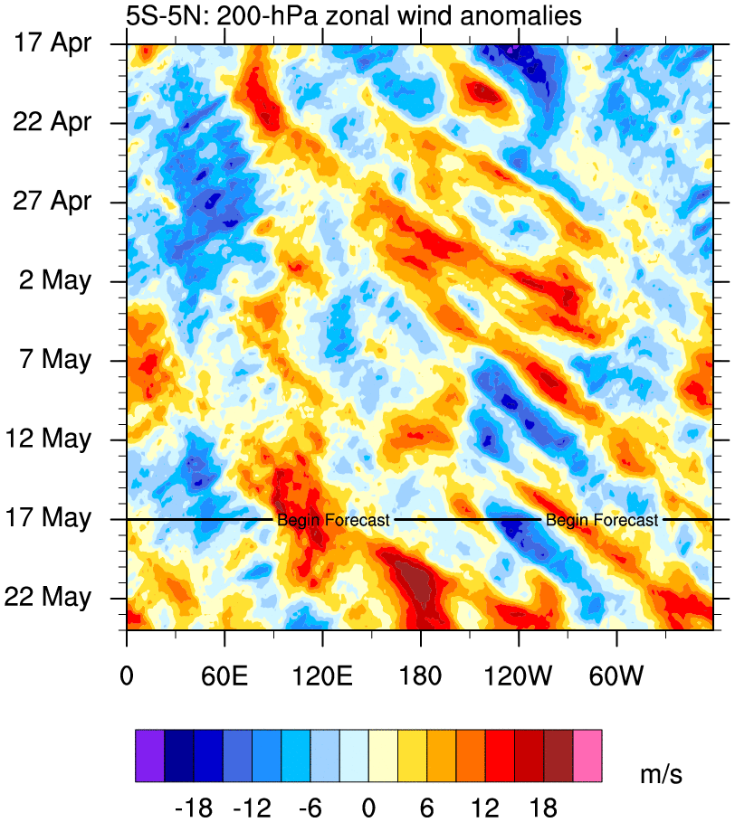
Convection apparent...


Frank_Wx- Godzilla Seeker

- Posts : 21305
Join date : 2013-01-05 -

Re: Long Range Thread 13.0
![]() by rb924119 Mon Jan 16, 2017 10:07 am
by rb924119 Mon Jan 16, 2017 10:07 am
Last edited by rb924119 on Mon Jan 16, 2017 10:15 am; edited 1 time in total
rb924119- Meteorologist

- Posts : 6889
Join date : 2013-02-06
Re: Long Range Thread 13.0
![]() by Radz Mon Jan 16, 2017 10:07 am
by Radz Mon Jan 16, 2017 10:07 am

Radz- Pro Enthusiast

- Posts : 1028
Reputation : 17
Join date : 2013-01-12
Location : Cortlandt Manor NY
Re: Long Range Thread 13.0
![]() by Armando Salvadore Mon Jan 16, 2017 10:39 am
by Armando Salvadore Mon Jan 16, 2017 10:39 am
Frank_Wx wrote:As Nutley mentioned, and what we all predicted, the GEFS reverted back to showing major Pacific blocking and trough placement on the EC to match the EPS.
The pattern after the 27th will rock. Snowstorm signal growing stronger.

Ahhh, it only took one more run to get that to convert towards the EPS. Yea, can't say i'm shocked since we saw it coming.

Armando Salvadore- Advanced Forecaster

- Posts : 171
Reputation : 0
Join date : 2016-12-23
Location : Springfield, NJ
Re: Long Range Thread 13.0
![]() by sroc4 Mon Jan 16, 2017 11:06 am
by sroc4 Mon Jan 16, 2017 11:06 am
Armando Salvadore wrote:Frank_Wx wrote:As Nutley mentioned, and what we all predicted, the GEFS reverted back to showing major Pacific blocking and trough placement on the EC to match the EPS.
The pattern after the 27th will rock. Snowstorm signal growing stronger.
Ahhh, it only took one more run to get that to convert towards the EPS. Yea, can't say i'm shocked since we saw it coming.
How about a collective High five! lol Obv things can change but...

_________________
"In weather and in life, there's no winning and losing; there's only winning and learning."
WINTER 2012/2013 TOTALS 43.65"WINTER 2017/2018 TOTALS 62.85" WINTER 2022/2023 TOTALS 4.9"
WINTER 2013/2014 TOTALS 64.85"WINTER 2018/2019 TOTALS 14.25" WINTER 2023/2024 TOTALS 13.1"
WINTER 2014/2015 TOTALS 71.20"WINTER 2019/2020 TOTALS 6.35"
WINTER 2015/2016 TOTALS 35.00"WINTER 2020/2021 TOTALS 37.75"
WINTER 2016/2017 TOTALS 42.25"WINTER 2021/2022 TOTALS 31.65"

sroc4- Admin
- Posts : 8331
Reputation : 301
Join date : 2013-01-07
Location : Wading River, LI
Re: Long Range Thread 13.0
![]() by Frank_Wx Mon Jan 16, 2017 11:17 am
by Frank_Wx Mon Jan 16, 2017 11:17 am

_________________
_______________________________________________________________________________________________________
CLICK HERE to view NJ Strong Snowstorm Classifications

Frank_Wx- Godzilla Seeker
- Posts : 21305
Reputation : 328
Join date : 2013-01-05
Age : 31
Location : Jersey City, NJ -
Re: Long Range Thread 13.0
![]() by algae888 Mon Jan 16, 2017 11:28 am
by algae888 Mon Jan 16, 2017 11:28 am
That's awesome and if you extrapolate out it should return to seven eight and one at the end of February at least that's what the long range EPS showsFrank_Wx wrote:

algae888- Advanced Forecaster
- Posts : 5311
Reputation : 46
Join date : 2013-02-05
Age : 61
Location : mt. vernon, new york
Re: Long Range Thread 13.0
![]() by rb924119 Mon Jan 16, 2017 11:29 am
by rb924119 Mon Jan 16, 2017 11:29 am
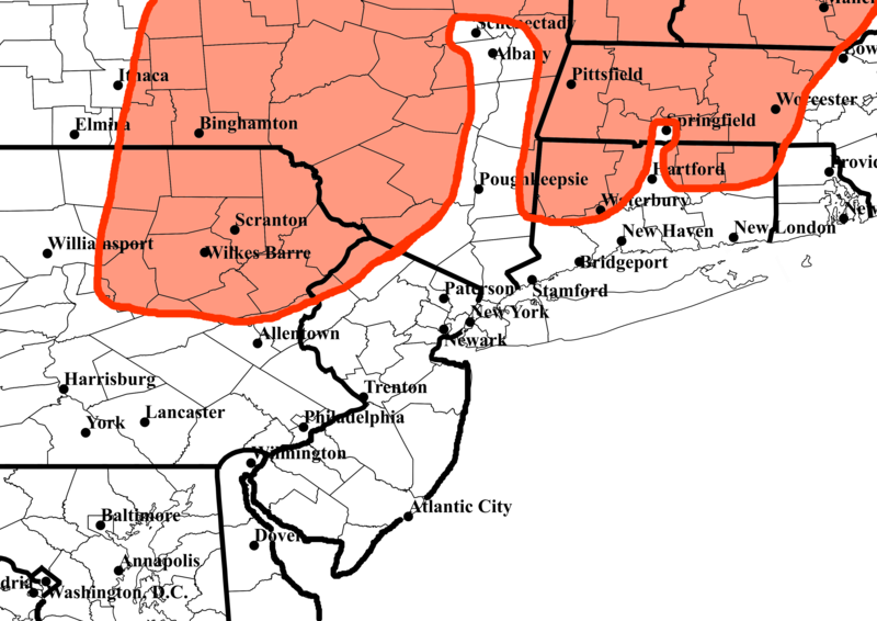
https://drive.google.com/open?id=0Byod2Sk27yNYUmRrZjF5RmQwS0E
Again, I would like to reiterate that I could be completely off with this, and there is no precipitation that lags behind by the time that the lower-level cold air can be drawn in. Likewise, the chance that there is an interaction with energies could very well be non-existent (I caution that there is only a chance of interaction at this time, not certainty) and there might not be enough upper-level forcing mechanisms to promote precipitation. At any rate, enough looking for scapegoats. Enjoy!!
For reference, here is the map highlighting the areas that could potentially be surprised with wintry precipitation (shaded in red):
rb924119- Meteorologist
- Posts : 6889
Reputation : 194
Join date : 2013-02-06
Age : 32
Location : Greentown, Pa
Re: Long Range Thread 13.0
![]() by algae888 Mon Jan 16, 2017 11:31 am
by algae888 Mon Jan 16, 2017 11:31 am
algae888- Advanced Forecaster
- Posts : 5311
Reputation : 46
Join date : 2013-02-05
Age : 61
Location : mt. vernon, new york
Re: Long Range Thread 13.0
![]() by amugs Mon Jan 16, 2017 11:51 am
by amugs Mon Jan 16, 2017 11:51 am
algae888 wrote:Rb and Scott did you see today's 12z GFS snow for at least the interior and close to the coast you guessed it mugs on Saturday. Rb and scott are all over this one. With that block in Canada everything's going to go underneath us and forget about this torch Saturday and Sunday look cold.
Al I am seeing maybe two day torch so to speak as we are on the western side of this cutter next week which looks to be a beast but it looks like a backdoor cold front sweeps in for this weekend. HP is in NE and it may snow - another fn Saturday SOAB!! Interesting what seems to be a torchy period as has been advertised is cooling off to be AN overall. IF we can get out of this next 8 days a plus 4 or 5 overall I would call that a win and then the poop hits the fan after this 25th through late Feb.
Remember that the EPS leads and always will with the H5 maps and recognizing the set up as I have learned, GEFS play catch up. I have to say I am not a betting man overall but I would bet a round of drinks at our next gathering that we reach N MYC metro Area to (double the bet for the next call - AN!)AN by Middle of Feb snowfall with this set up coming and we are entering the snowiest climatology part of the winter (February).
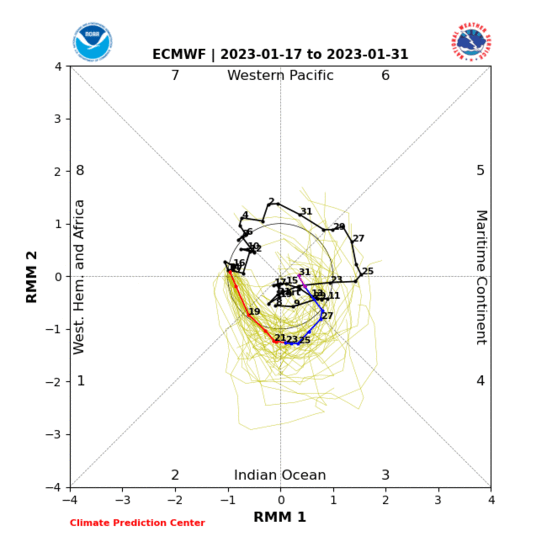
Love eth look of the MJO phase 8 1 2 for the late Jan through FEB time frame is absolutely gorgeous!!
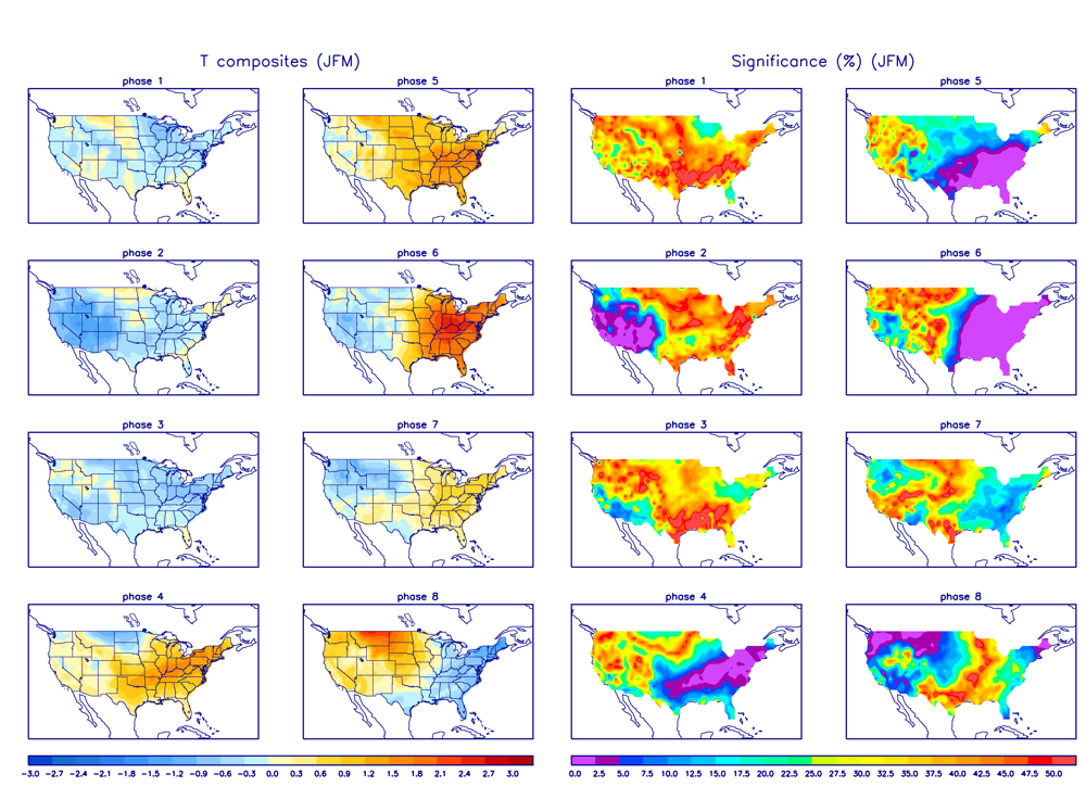
ALL MJO MODELS have us going 8 1 2!
Here is the site - to much to copy and past - follow the yellow brook road !
http://www.daculaweather.com/4_mjo_phase_forecast.php

_________________
Mugs
AKA:King: Snow Weenie
Self Proclaimed
WINTER 2014-15 : 55.12" +.02 for 6 coatings (avg. 35")
WINTER 2015-16 Total - 29.8" (Avg 35")
WINTER 2016-17 : 39.5" so far

amugs- Advanced Forecaster - Mod

- Posts : 15093
Reputation : 213
Join date : 2013-01-07
Age : 54
Location : Hillsdale,NJ
Re: Long Range Thread 13.0
![]() by skinsfan1177 Mon Jan 16, 2017 12:30 pm
by skinsfan1177 Mon Jan 16, 2017 12:30 pm
Last edited by skinsfan1177 on Mon Jan 16, 2017 12:33 pm; edited 1 time in total

skinsfan1177- Senior Enthusiast

- Posts : 4485
Reputation : 35
Join date : 2013-01-07
Age : 46
Location : Point Pleasant Boro
skinsfan1177- Senior Enthusiast
- Posts : 4485
Reputation : 35
Join date : 2013-01-07
Age : 46
Location : Point Pleasant Boro
Re: Long Range Thread 13.0
![]() by Frank_Wx Mon Jan 16, 2017 12:39 pm
by Frank_Wx Mon Jan 16, 2017 12:39 pm
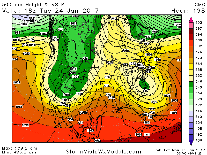
skinsfan1177 wrote:Has anyone looked at the storm around the 24th l. Jman the winds look bad and heavy rain. Can anyone elaborate on this threat.
This could be bad. I'll start a thread on it Wednesday.
_________________
_______________________________________________________________________________________________________
CLICK HERE to view NJ Strong Snowstorm Classifications
Frank_Wx- Godzilla Seeker
- Posts : 21305
Reputation : 328
Join date : 2013-01-05
Age : 31
Location : Jersey City, NJ -
Re: Long Range Thread 13.0
![]() by Frank_Wx Mon Jan 16, 2017 12:46 pm
by Frank_Wx Mon Jan 16, 2017 12:46 pm
Frank_Wx wrote:skinsfan1177 wrote:Has anyone looked at the storm around the 24th l. Jman the winds look bad and heavy rain. Can anyone elaborate on this threat.
This could be bad. I'll start a thread on it Wednesday.
To elaborate, it would be a wind-driven rainstorm.
_________________
_______________________________________________________________________________________________________
CLICK HERE to view NJ Strong Snowstorm Classifications
Frank_Wx- Godzilla Seeker
- Posts : 21305
Reputation : 328
Join date : 2013-01-05
Age : 31
Location : Jersey City, NJ -
Re: Long Range Thread 13.0
![]() by SoulSingMG Mon Jan 16, 2017 12:59 pm
by SoulSingMG Mon Jan 16, 2017 12:59 pm


SoulSingMG- Senior Enthusiast
- Posts : 2853
Reputation : 74
Join date : 2013-12-11
Location : Long Island City, NY
Re: Long Range Thread 13.0
![]() by Frank_Wx Mon Jan 16, 2017 1:02 pm
by Frank_Wx Mon Jan 16, 2017 1:02 pm
SoulSingMG wrote:Not sure I remember a rainstorm getting so much buzz during the Winter....
The damn CMC floods us.

_________________
_______________________________________________________________________________________________________
CLICK HERE to view NJ Strong Snowstorm Classifications
Frank_Wx- Godzilla Seeker
- Posts : 21305
Reputation : 328
Join date : 2013-01-05
Age : 31
Location : Jersey City, NJ -
Re: Long Range Thread 13.0
![]() by algae888 Mon Jan 16, 2017 1:04 pm
by algae888 Mon Jan 16, 2017 1:04 pm
Frank I wouldn't discount snow especially for the interior areas as we are in late January and a track to or south with a low bombing out could produce its own cold air plus we have high pressure to the north which could funnel in cold air also but yeah rain seems more likely at the momentFrank_Wx wrote:Frank_Wx wrote:skinsfan1177 wrote:Has anyone looked at the storm around the 24th l. Jman the winds look bad and heavy rain. Can anyone elaborate on this threat.
This could be bad. I'll start a thread on it Wednesday.
To elaborate, it would be a wind-driven rainstorm.
algae888- Advanced Forecaster
- Posts : 5311
Reputation : 46
Join date : 2013-02-05
Age : 61
Location : mt. vernon, new york
Re: Long Range Thread 13.0
![]() by CPcantmeasuresnow Mon Jan 16, 2017 1:33 pm
by CPcantmeasuresnow Mon Jan 16, 2017 1:33 pm
algae888 wrote:Frank I wouldn't discount snow especially for the interior areas as we are in late January and a track to or south with a low bombing out could produce its own cold air plus we have high pressure to the north which could funnel in cold air also but yeah rain seems more likely at the momentFrank_Wx wrote:Frank_Wx wrote:skinsfan1177 wrote:Has anyone looked at the storm around the 24th l. Jman the winds look bad and heavy rain. Can anyone elaborate on this threat.
This could be bad. I'll start a thread on it Wednesday.
To elaborate, it would be a wind-driven rainstorm.
Not likely, but certainly as you say Al for the time of year definitely not to be ruled out.

CPcantmeasuresnow- Wx Statistician Guru

- Posts : 7274
Reputation : 230
Join date : 2013-01-07
Age : 103
Location : Eastern Orange County, NY
Re: Long Range Thread 13.0
![]() by algae888 Mon Jan 16, 2017 2:16 pm
by algae888 Mon Jan 16, 2017 2:16 pm
algae888- Advanced Forecaster
- Posts : 5311
Reputation : 46
Join date : 2013-02-05
Age : 61
Location : mt. vernon, new york
Re: Long Range Thread 13.0
![]() by amugs Mon Jan 16, 2017 2:23 pm
by amugs Mon Jan 16, 2017 2:23 pm


_________________
Mugs
AKA:King: Snow Weenie
Self Proclaimed
WINTER 2014-15 : 55.12" +.02 for 6 coatings (avg. 35")
WINTER 2015-16 Total - 29.8" (Avg 35")
WINTER 2016-17 : 39.5" so far
amugs- Advanced Forecaster - Mod
- Posts : 15093
Reputation : 213
Join date : 2013-01-07
Age : 54
Location : Hillsdale,NJ
Re: Long Range Thread 13.0
![]() by amugs Mon Jan 16, 2017 2:28 pm
by amugs Mon Jan 16, 2017 2:28 pm

_________________
Mugs
AKA:King: Snow Weenie
Self Proclaimed
WINTER 2014-15 : 55.12" +.02 for 6 coatings (avg. 35")
WINTER 2015-16 Total - 29.8" (Avg 35")
WINTER 2016-17 : 39.5" so far
amugs- Advanced Forecaster - Mod
- Posts : 15093
Reputation : 213
Join date : 2013-01-07
Age : 54
Location : Hillsdale,NJ
Re: Long Range Thread 13.0
![]() by amugs Mon Jan 16, 2017 2:41 pm
by amugs Mon Jan 16, 2017 2:41 pm


WOW
_________________
Mugs
AKA:King: Snow Weenie
Self Proclaimed
WINTER 2014-15 : 55.12" +.02 for 6 coatings (avg. 35")
WINTER 2015-16 Total - 29.8" (Avg 35")
WINTER 2016-17 : 39.5" so far
amugs- Advanced Forecaster - Mod
- Posts : 15093
Reputation : 213
Join date : 2013-01-07
Age : 54
Location : Hillsdale,NJ
Re: Long Range Thread 13.0
![]() by algae888 Mon Jan 16, 2017 2:41 pm
by algae888 Mon Jan 16, 2017 2:41 pm


I would give us a 25% chance of snow the next 10 days in the midst of the torch! pattern change after. fun times ahead
algae888- Advanced Forecaster
- Posts : 5311
Reputation : 46
Join date : 2013-02-05
Age : 61
Location : mt. vernon, new york
Re: Long Range Thread 13.0
![]() by Frank_Wx Mon Jan 16, 2017 2:58 pm
by Frank_Wx Mon Jan 16, 2017 2:58 pm
_________________
_______________________________________________________________________________________________________
CLICK HERE to view NJ Strong Snowstorm Classifications
Frank_Wx- Godzilla Seeker
- Posts : 21305
Reputation : 328
Join date : 2013-01-05
Age : 31
Location : Jersey City, NJ -
Re: Long Range Thread 13.0
![]() by algae888 Mon Jan 16, 2017 3:02 pm
by algae888 Mon Jan 16, 2017 3:02 pm
frank not seeing +++ just + which we can work with in late January. look at this signal on gefs and geps some one in our area will snow with this track..Frank_Wx wrote:Insane block in south central Canada on the EURO. It does some odd things at 500mb, but the signal for a high impact event is there. I will not discount snow but I find it highly improbable. I don't think the pattern is ready for snow that soon after seeing +++ temp departures.


algae888- Advanced Forecaster
- Posts : 5311
Reputation : 46
Join date : 2013-02-05
Age : 61
Location : mt. vernon, new york
Re: Long Range Thread 13.0
![]() by nutleyblizzard Mon Jan 16, 2017 3:06 pm
by nutleyblizzard Mon Jan 16, 2017 3:06 pm
The damn primary drives up warm air into the area ahead of the storm and we end up as rain. we're going to need the primary to transfer quicker for things to get interesting.algae888 wrote:mugs that block in c/Canada stays there for 5 days. nothing cutting with that look..
I would give us a 25% chance of snow the next 10 days in the midst of the torch! pattern change after. fun times ahead

nutleyblizzard- Senior Enthusiast
- Posts : 1952
Reputation : 41
Join date : 2014-01-30
Age : 58
Location : Nutley, new jersey
Re: Long Range Thread 13.0
![]() by algae888 Mon Jan 16, 2017 3:16 pm
by algae888 Mon Jan 16, 2017 3:16 pm


then 2nd system tues/ wens 7am and 1 pm.


not to far off upp/30's / low 40's so if system bombs out it will produce it's own cold air. agree set up is not great with regards to cold air but remember we are in late jan so cold will be available further up in atmosphere. we need right track and bomb out south of us and we can snow.
algae888- Advanced Forecaster
- Posts : 5311
Reputation : 46
Join date : 2013-02-05
Age : 61
Location : mt. vernon, new york
Page 31 of 40 • 1 ... 17 ... 30, 31, 32 ... 35 ... 40 ![]()
|
|
|