
 Search
January 22nd-23rd High Impact Storm
Page 6 of 13 •  1, 2, 3 ... 5, 6, 7 ... 11, 12, 13
 ![]()
Re: January 22nd-23rd High Impact Storm
![]() by rb924119 Thu Jan 19, 2017 1:12 pm
by rb924119 Thu Jan 19, 2017 1:12 pm
rb924119- Meteorologist

- Posts : 6889
Join date : 2013-02-06
Re: January 22nd-23rd High Impact Storm
![]() by rb924119 Thu Jan 19, 2017 1:14 pm
by rb924119 Thu Jan 19, 2017 1:14 pm
rb924119- Meteorologist
- Posts : 6889
Join date : 2013-02-06
Re: January 22nd-23rd High Impact Storm
![]() by rb924119 Thu Jan 19, 2017 1:17 pm
by rb924119 Thu Jan 19, 2017 1:17 pm
rb924119- Meteorologist
- Posts : 6889
Reputation : 194
Join date : 2013-02-06
Age : 32
Location : Greentown, Pa
Re: January 22nd-23rd High Impact Storm
![]() by amugs Thu Jan 19, 2017 1:21 pm
by amugs Thu Jan 19, 2017 1:21 pm
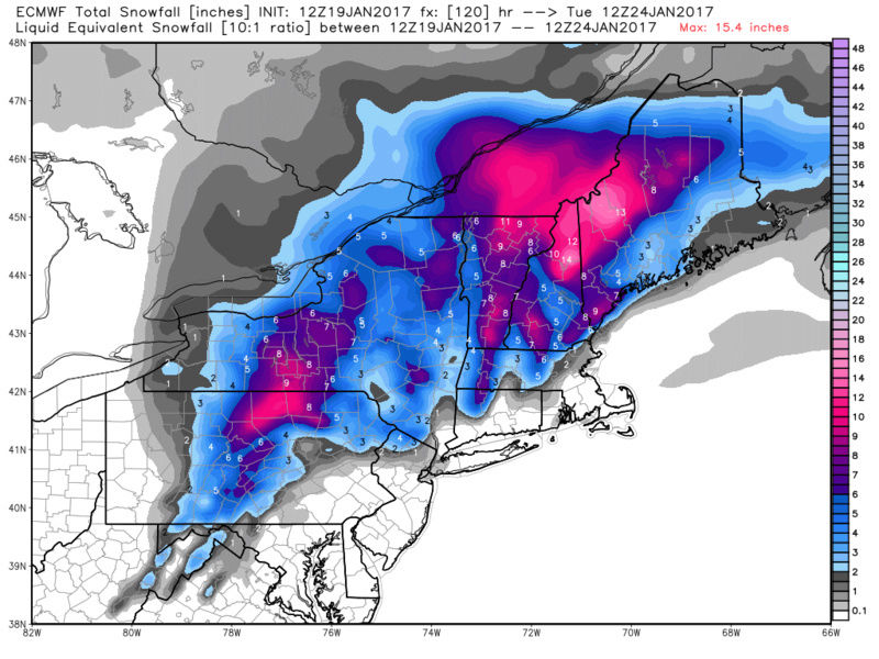
Interior get crushed with snow

_________________
Mugs
AKA:King: Snow Weenie
Self Proclaimed
WINTER 2014-15 : 55.12" +.02 for 6 coatings (avg. 35")
WINTER 2015-16 Total - 29.8" (Avg 35")
WINTER 2016-17 : 39.5" so far

amugs- Advanced Forecaster - Mod

- Posts : 15093
Reputation : 213
Join date : 2013-01-07
Age : 54
Location : Hillsdale,NJ
Re: January 22nd-23rd High Impact Storm
![]() by rb924119 Thu Jan 19, 2017 1:21 pm
by rb924119 Thu Jan 19, 2017 1:21 pm
rb924119- Meteorologist
- Posts : 6889
Reputation : 194
Join date : 2013-02-06
Age : 32
Location : Greentown, Pa
Re: January 22nd-23rd High Impact Storm
![]() by Frank_Wx Thu Jan 19, 2017 1:21 pm
by Frank_Wx Thu Jan 19, 2017 1:21 pm


_________________
_______________________________________________________________________________________________________
CLICK HERE to view NJ Strong Snowstorm Classifications

Frank_Wx- Godzilla Seeker

- Posts : 21305
Reputation : 328
Join date : 2013-01-05
Age : 31
Location : Jersey City, NJ -

Re: January 22nd-23rd High Impact Storm
![]() by Frank_Wx Thu Jan 19, 2017 1:22 pm
by Frank_Wx Thu Jan 19, 2017 1:22 pm

_________________
_______________________________________________________________________________________________________
CLICK HERE to view NJ Strong Snowstorm Classifications
Frank_Wx- Godzilla Seeker
- Posts : 21305
Reputation : 328
Join date : 2013-01-05
Age : 31
Location : Jersey City, NJ -
Re: January 22nd-23rd High Impact Storm
![]() by amugs Thu Jan 19, 2017 1:23 pm
by amugs Thu Jan 19, 2017 1:23 pm
_________________
Mugs
AKA:King: Snow Weenie
Self Proclaimed
WINTER 2014-15 : 55.12" +.02 for 6 coatings (avg. 35")
WINTER 2015-16 Total - 29.8" (Avg 35")
WINTER 2016-17 : 39.5" so far
amugs- Advanced Forecaster - Mod
- Posts : 15093
Reputation : 213
Join date : 2013-01-07
Age : 54
Location : Hillsdale,NJ
Re: January 22nd-23rd High Impact Storm
![]() by rb924119 Thu Jan 19, 2017 1:27 pm
by rb924119 Thu Jan 19, 2017 1:27 pm
rb924119- Meteorologist
- Posts : 6889
Reputation : 194
Join date : 2013-02-06
Age : 32
Location : Greentown, Pa
Re: January 22nd-23rd High Impact Storm
![]() by skinsfan1177 Thu Jan 19, 2017 1:28 pm
by skinsfan1177 Thu Jan 19, 2017 1:28 pm

skinsfan1177- Senior Enthusiast

- Posts : 4485
Reputation : 35
Join date : 2013-01-07
Age : 46
Location : Point Pleasant Boro
Re: January 22nd-23rd High Impact Storm
![]() by SENJsnowman Thu Jan 19, 2017 1:45 pm
by SENJsnowman Thu Jan 19, 2017 1:45 pm
SENJsnowman- Senior Enthusiast
- Posts : 1186
Reputation : 61
Join date : 2017-01-06
Age : 51
Location : Bayville, NJ
Re: January 22nd-23rd High Impact Storm
![]() by jmanley32 Thu Jan 19, 2017 1:50 pm
by jmanley32 Thu Jan 19, 2017 1:50 pm

jmanley32- Senior Enthusiast
- Posts : 20513
Reputation : 108
Join date : 2013-12-12
Age : 42
Location : Yonkers, NY
Re: January 22nd-23rd High Impact Storm
![]() by sroc4 Thu Jan 19, 2017 1:52 pm
by sroc4 Thu Jan 19, 2017 1:52 pm
rb924119 wrote:Must admit the precipitation shield was a bit underwhelming, but evolution was amazing
Ive noticed this too on several runs on various models. Is this thing becoming occluded by the time it gets to us?
_________________
"In weather and in life, there's no winning and losing; there's only winning and learning."
WINTER 2012/2013 TOTALS 43.65"WINTER 2017/2018 TOTALS 62.85" WINTER 2022/2023 TOTALS 4.9"
WINTER 2013/2014 TOTALS 64.85"WINTER 2018/2019 TOTALS 14.25" WINTER 2023/2024 TOTALS 13.1"
WINTER 2014/2015 TOTALS 71.20"WINTER 2019/2020 TOTALS 6.35"
WINTER 2015/2016 TOTALS 35.00"WINTER 2020/2021 TOTALS 37.75"
WINTER 2016/2017 TOTALS 42.25"WINTER 2021/2022 TOTALS 31.65"

sroc4- Admin
- Posts : 8331
Reputation : 301
Join date : 2013-01-07
Location : Wading River, LI
Re: January 22nd-23rd High Impact Storm
![]() by jmanley32 Thu Jan 19, 2017 1:55 pm
by jmanley32 Thu Jan 19, 2017 1:55 pm
jmanley32- Senior Enthusiast
- Posts : 20513
Reputation : 108
Join date : 2013-12-12
Age : 42
Location : Yonkers, NY
Re: January 22nd-23rd High Impact Storm
![]() by jmanley32 Thu Jan 19, 2017 1:57 pm
by jmanley32 Thu Jan 19, 2017 1:57 pm
what does occluded mean again sroc? This looks like it may b a moderate rain and mainly wind threat. Was showing 5 plus inches rain few days ago.sroc4 wrote:rb924119 wrote:Must admit the precipitation shield was a bit underwhelming, but evolution was amazing
Ive noticed this too on several runs on various models. Is this thing becoming occluded by the time it gets to us?
jmanley32- Senior Enthusiast
- Posts : 20513
Reputation : 108
Join date : 2013-12-12
Age : 42
Location : Yonkers, NY
Re: January 22nd-23rd High Impact Storm
![]() by rb924119 Thu Jan 19, 2017 1:59 pm
by rb924119 Thu Jan 19, 2017 1:59 pm
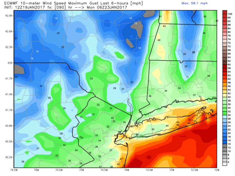
SENJsnowman wrote:Storm surge for the Shore?
Looks like about 3-4 feet right now on Monday.
rb924119- Meteorologist
- Posts : 6889
Reputation : 194
Join date : 2013-02-06
Age : 32
Location : Greentown, Pa
Re: January 22nd-23rd High Impact Storm
![]() by Guest Thu Jan 19, 2017 2:06 pm
by Guest Thu Jan 19, 2017 2:06 pm
Guest- Guest
Re: January 22nd-23rd High Impact Storm
![]() by rb924119 Thu Jan 19, 2017 2:11 pm
by rb924119 Thu Jan 19, 2017 2:11 pm
sroc4 wrote:rb924119 wrote:Must admit the precipitation shield was a bit underwhelming, but evolution was amazing
Ive noticed this too on several runs on various models. Is this thing becoming occluded by the time it gets to us?
Technically, yes, but that's not the reason. Right now as progged, the mid-level evolution is almost ideal for the interior, and just narrowly not so for the coastal plain. The reason why the precipitation fields are varying from model to model and run to run right now is because the exact placement and structure of the H5 low is still uncertain. Remember, your best forcing and dynamics occur roughly 200-300 miles on the north and northwest side of a closed mid-level low. The reason the Euro is "drier" is because it tracks the H5 low right over our area. So, we get part of the precipitation shield while it's over the Delmarva, but then notice how the axis of heaviest precipitation is centered through west-central NY and Pa as the H5 low moves overhead. The GFS, however, takes the H5 low with the same intensity evolution, and tracks off the Mid-Atlantic coast, allowing the "comma head" to work right through our whole area. The CMC is kind of like a blend of the Euro and GFS, although what it does with the H5 low beyond the Delmarva, along with its jet, makes little sense to me.
Does that help?
rb924119- Meteorologist
- Posts : 6889
Reputation : 194
Join date : 2013-02-06
Age : 32
Location : Greentown, Pa
Re: January 22nd-23rd High Impact Storm
![]() by algae888 Thu Jan 19, 2017 2:12 pm
by algae888 Thu Jan 19, 2017 2:12 pm

algae888- Advanced Forecaster

- Posts : 5311
Reputation : 46
Join date : 2013-02-05
Age : 61
Location : mt. vernon, new york
Re: January 22nd-23rd High Impact Storm
![]() by jmanley32 Thu Jan 19, 2017 2:13 pm
by jmanley32 Thu Jan 19, 2017 2:13 pm


Last edited by jmanley32 on Thu Jan 19, 2017 2:18 pm; edited 1 time in total
jmanley32- Senior Enthusiast
- Posts : 20513
Reputation : 108
Join date : 2013-12-12
Age : 42
Location : Yonkers, NY
Re: January 22nd-23rd High Impact Storm
![]() by jmanley32 Thu Jan 19, 2017 2:16 pm
by jmanley32 Thu Jan 19, 2017 2:16 pm
Like 1-3 inches for the area or so rain, no snow on euro unless well inland.TheAresian wrote:Does anybody have the WxBell qpf map for the grand totals?
right you will probably see snow, heres the map.
Last edited by jmanley32 on Thu Jan 19, 2017 2:20 pm; edited 1 time in total
jmanley32- Senior Enthusiast
- Posts : 20513
Reputation : 108
Join date : 2013-12-12
Age : 42
Location : Yonkers, NY
Re: January 22nd-23rd High Impact Storm
![]() by Guest Thu Jan 19, 2017 2:19 pm
by Guest Thu Jan 19, 2017 2:19 pm
Guest- Guest
Re: January 22nd-23rd High Impact Storm
![]() by rb924119 Thu Jan 19, 2017 2:22 pm
by rb924119 Thu Jan 19, 2017 2:22 pm
rb924119- Meteorologist
- Posts : 6889
Reputation : 194
Join date : 2013-02-06
Age : 32
Location : Greentown, Pa
Re: January 22nd-23rd High Impact Storm
![]() by sroc4 Thu Jan 19, 2017 2:23 pm
by sroc4 Thu Jan 19, 2017 2:23 pm
rb924119 wrote:Personally, while I think the Euro is on track on the broad scale, I think it's misrepresenting the H5 low and resultant precipitation field.
There is a ton of vorticity that doesnt begin coming ashore for 48hrs. Long way to go.
_________________
"In weather and in life, there's no winning and losing; there's only winning and learning."
WINTER 2012/2013 TOTALS 43.65"WINTER 2017/2018 TOTALS 62.85" WINTER 2022/2023 TOTALS 4.9"
WINTER 2013/2014 TOTALS 64.85"WINTER 2018/2019 TOTALS 14.25" WINTER 2023/2024 TOTALS 13.1"
WINTER 2014/2015 TOTALS 71.20"WINTER 2019/2020 TOTALS 6.35"
WINTER 2015/2016 TOTALS 35.00"WINTER 2020/2021 TOTALS 37.75"
WINTER 2016/2017 TOTALS 42.25"WINTER 2021/2022 TOTALS 31.65"
sroc4- Admin
- Posts : 8331
Reputation : 301
Join date : 2013-01-07
Location : Wading River, LI
Re: January 22nd-23rd High Impact Storm
![]() by jmanley32 Thu Jan 19, 2017 2:24 pm
by jmanley32 Thu Jan 19, 2017 2:24 pm
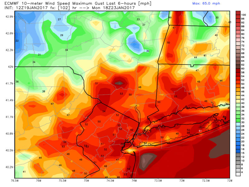
We envy you on this one! We would much rather it be snow and wind than rain and wind, though a heavy wet snow and 50-60mph winds would be even worse for trees.TheAresian wrote:I'm definitely well inland. And I definitely do NOT envy you guys.
jmanley32- Senior Enthusiast
- Posts : 20513
Reputation : 108
Join date : 2013-12-12
Age : 42
Location : Yonkers, NY
Re: January 22nd-23rd High Impact Storm
![]() by jmanley32 Thu Jan 19, 2017 2:25 pm
by jmanley32 Thu Jan 19, 2017 2:25 pm
sroc4 wrote:rb924119 wrote:Personally, while I think the Euro is on track on the broad scale, I think it's misrepresenting the H5 low and resultant precipitation field.
There is a ton of vorticity that doesnt begin coming ashore for 48hrs. Long way to go.
Dos this have to possibility to be even more intense say sub 970mb? Giving us even more insane winds, and wouldnt that also bring in enough of its own cold air to bring snow right down to the coast or close?
jmanley32- Senior Enthusiast
- Posts : 20513
Reputation : 108
Join date : 2013-12-12
Age : 42
Location : Yonkers, NY
Re: January 22nd-23rd High Impact Storm
![]() by rb924119 Thu Jan 19, 2017 2:26 pm
by rb924119 Thu Jan 19, 2017 2:26 pm
sroc4 wrote:rb924119 wrote:Personally, while I think the Euro is on track on the broad scale, I think it's misrepresenting the H5 low and resultant precipitation field.
There is a ton of vorticity that doesnt begin coming ashore for 48hrs. Long way to go.
Agreed lol I'm looking VERY forward the Euro Ensembles haha
rb924119- Meteorologist
- Posts : 6889
Reputation : 194
Join date : 2013-02-06
Age : 32
Location : Greentown, Pa
Page 6 of 13 • 1, 2, 3 ... 5, 6, 7 ... 11, 12, 13 ![]()
|
|
|