
 Search
Long Range Thread 13.0
Page 37 of 40 •  1 ... 20 ... 36, 37, 38, 39, 40
 ![]()
Re: Long Range Thread 13.0
![]() by jmanley32 Wed Mar 08, 2017 7:33 am
by jmanley32 Wed Mar 08, 2017 7:33 am
jmanley32- Senior Enthusiast

- Posts : 20535
Join date : 2013-12-12
Re: Long Range Thread 13.0
![]() by amugs Wed Mar 08, 2017 7:35 am
by amugs Wed Mar 08, 2017 7:35 am
jmanley32 wrote:my only worry is sp did euro for Sunday then poof. Does this one have a much more promising setup with less room for suppression or other problems to arise?amugs wrote:nutleyblizzard wrote:What a run by the 6Z GFS. Shows a slow moving blizzard on Tuesday. Unable to post snow map, but shows 15-30 inches. Very strong signal for a big storm, although EURO not on board yet has me somewhat concerned. Although I'm hearing the EPS was much improved last night. Still 5-6 days away so a lot can change for better or worse.

AS progged now and no reason for concern just watch - block weakens a bit or retrogresses allowing this is slide up the coast witha pna spike to help as progged.
amugs- Advanced Forecaster - Mod

- Posts : 15095
Join date : 2013-01-07
Re: Long Range Thread 13.0
![]() by nutleyblizzard Wed Mar 08, 2017 7:49 am
by nutleyblizzard Wed Mar 08, 2017 7:49 am
There are a couple of scenarios that might occur which would screw things up. One of less concern is if wave 2 comes much farther north than progged. if that were to happen, it might mess with heights along the east coast. I don't see that happening though. Of more of a concern is our monster storm really amping up to the point where it cuts inland.jmanley32 wrote:my only worry is sp did euro for Sunday then poof. Does this one have a much more promising setup with less room for suppression or other problems to arise?amugs wrote:nutleyblizzard wrote:What a run by the 6Z GFS. Shows a slow moving blizzard on Tuesday. Unable to post snow map, but shows 15-30 inches. Very strong signal for a big storm, although EURO not on board yet has me somewhat concerned. Although I'm hearing the EPS was much improved last night. Still 5-6 days away so a lot can change for better or worse.

nutleyblizzard- Senior Enthusiast
- Posts : 1954
Reputation : 41
Join date : 2014-01-30
Age : 58
Location : Nutley, new jersey
Re: Long Range Thread 13.0
![]() by jmanley32 Wed Mar 08, 2017 8:15 am
by jmanley32 Wed Mar 08, 2017 8:15 am
like the euro shows. But gfs ramps it up in the perfect spot.nutleyblizzard wrote:There are a couple of scenarios that might occur which would screw things up. One of less concern is if wave 2 comes much farther north than progged. if that were to happen, it might mess with heights along the east coast. I don't see that happening though. Of more of a concern is our monster storm really amping up to the point where it cuts inland.jmanley32 wrote:my only worry is sp did euro for Sunday then poof. Does this one have a much more promising setup with less room for suppression or other problems to arise?amugs wrote:nutleyblizzard wrote:What a run by the 6Z GFS. Shows a slow moving blizzard on Tuesday. Unable to post snow map, but shows 15-30 inches. Very strong signal for a big storm, although EURO not on board yet has me somewhat concerned. Although I'm hearing the EPS was much improved last night. Still 5-6 days away so a lot can change for better or worse.

jmanley32- Senior Enthusiast
- Posts : 20535
Reputation : 108
Join date : 2013-12-12
Age : 43
Location : Yonkers, NY
Re: Long Range Thread 13.0
![]() by Frank_Wx Wed Mar 08, 2017 8:21 am
by Frank_Wx Wed Mar 08, 2017 8:21 am

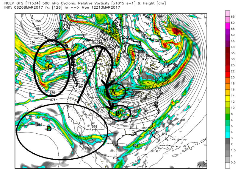
Here is a snapshot of the pattern Saturday morning. A piece of the PV is in SE Canada and there is a fierce -NAO/-WPO signature with ridging over Greenland and NW of Alaska. As this PV lobe lifts north and gets trapped under the NAO block, it creates a traffic jam in the atmosphere which allows upper energy downstream to consolidate at the base of a mid-level trough.

By early Tuesday morning, there is a full latitude trough over the eastern CONUS rapidly turning neutral to negative. The PNA ridge spike is a critical feature to get the northern stream energy to dig into the trough. If that feature is not there, the energy will remain over the Great Lakes and we'll be left with either no storm or a much less robust looking one. This does have Roidzilla potential and should be watched.
_________________
_______________________________________________________________________________________________________
CLICK HERE to view NJ Strong Snowstorm Classifications

Frank_Wx- Godzilla Seeker

- Posts : 21305
Reputation : 328
Join date : 2013-01-05
Age : 32
Location : Jersey City, NJ -

Re: Long Range Thread 13.0
![]() by Frank_Wx Wed Mar 08, 2017 8:23 am
by Frank_Wx Wed Mar 08, 2017 8:23 am

_________________
_______________________________________________________________________________________________________
CLICK HERE to view NJ Strong Snowstorm Classifications
Frank_Wx- Godzilla Seeker
- Posts : 21305
Reputation : 328
Join date : 2013-01-05
Age : 32
Location : Jersey City, NJ -
Re: Long Range Thread 13.0
![]() by skinsfan1177 Wed Mar 08, 2017 8:36 am
by skinsfan1177 Wed Mar 08, 2017 8:36 am

skinsfan1177- Senior Enthusiast
- Posts : 4485
Reputation : 35
Join date : 2013-01-07
Age : 46
Location : Point Pleasant Boro
Re: Long Range Thread 13.0
![]() by sroc4 Wed Mar 08, 2017 9:03 am
by sroc4 Wed Mar 08, 2017 9:03 am
The result of the PNA ridge as the euro depicts is such that A is not as robust and consolidated when compared to the GFS, and B is further N and more strung out because the flow east of it is more progressive when compared to the GFS. Again all due to the differences in the Western Ridge.
The timing is perfect on the GFS. The positioning of B relative to A along with the stronger W Ridge allows A to dive sharply S ward into the Bck side of B which phases te two streams and like Frank said, tilts the trough neutral then neg leading to a storm track up the coast. Because the Euro is less robust with the W Ridge the interactions between A and B are less impressive and the storm track is flatter, and because B is further N to start so is the surface LP as it reaches the coast.
Lastly there is energy labled D. Notice on the Euro strong vorticity extends well into the SW conus aroud the Az/NM region; whereas; the GFS has it held back and dips south and remains into Mexico. This may be one reason why the S stream is not allowed to dig as deep on the euro.
This def screams some form of a Miller B or surface LP transfer to the coast. LOOOONG way to go with this one. GFS is nice but its not under 72hrs so pefect at this time frame is less than perfect.
We Track!


Last edited by sroc4 on Wed Mar 08, 2017 2:19 pm; edited 1 time in total
_________________
"In weather and in life, there's no winning and losing; there's only winning and learning."
WINTER 2012/2013 TOTALS 43.65"WINTER 2017/2018 TOTALS 62.85" WINTER 2022/2023 TOTALS 4.9"
WINTER 2013/2014 TOTALS 64.85"WINTER 2018/2019 TOTALS 14.25" WINTER 2023/2024 TOTALS 13.1"
WINTER 2014/2015 TOTALS 71.20"WINTER 2019/2020 TOTALS 6.35"
WINTER 2015/2016 TOTALS 35.00"WINTER 2020/2021 TOTALS 37.75"
WINTER 2016/2017 TOTALS 42.25"WINTER 2021/2022 TOTALS 31.65"

sroc4- Admin
- Posts : 8354
Reputation : 302
Join date : 2013-01-07
Location : Wading River, LI
Re: Long Range Thread 13.0
![]() by weatherwatchermom Wed Mar 08, 2017 10:25 am
by weatherwatchermom Wed Mar 08, 2017 10:25 am

weatherwatchermom- Senior Enthusiast
- Posts : 3793
Reputation : 78
Join date : 2014-11-25
Location : Hazlet Township, NJ
Re: Long Range Thread 13.0
![]() by nutleyblizzard Wed Mar 08, 2017 11:34 am
by nutleyblizzard Wed Mar 08, 2017 11:34 am
nutleyblizzard- Senior Enthusiast
- Posts : 1954
Reputation : 41
Join date : 2014-01-30
Age : 58
Location : Nutley, new jersey
Re: Long Range Thread 13.0
![]() by jmanley32 Wed Mar 08, 2017 11:54 am
by jmanley32 Wed Mar 08, 2017 11:54 am
but it must be very light as its about 10-12 inches around city subtract 2 thats 10 inches max in 36 hrs, very light will probably not stick during day if its not blitzing. in 36 hrs id expect to see at least roidzilla if not frankzilla amounts if it was snowing at a good rate.nutleyblizzard wrote:GFS 12z storm on Tuesday is a long duration crush job. It snows for 36 hours!
jmanley32- Senior Enthusiast
- Posts : 20535
Reputation : 108
Join date : 2013-12-12
Age : 43
Location : Yonkers, NY
jmanley32- Senior Enthusiast
- Posts : 20535
Reputation : 108
Join date : 2013-12-12
Age : 43
Location : Yonkers, NY
Re: Long Range Thread 13.0
![]() by Frank_Wx Wed Mar 08, 2017 12:39 pm
by Frank_Wx Wed Mar 08, 2017 12:39 pm

_________________
_______________________________________________________________________________________________________
CLICK HERE to view NJ Strong Snowstorm Classifications
Frank_Wx- Godzilla Seeker
- Posts : 21305
Reputation : 328
Join date : 2013-01-05
Age : 32
Location : Jersey City, NJ -
Re: Long Range Thread 13.0
![]() by Frank_Wx Wed Mar 08, 2017 1:26 pm
by Frank_Wx Wed Mar 08, 2017 1:26 pm

_________________
_______________________________________________________________________________________________________
CLICK HERE to view NJ Strong Snowstorm Classifications
Frank_Wx- Godzilla Seeker
- Posts : 21305
Reputation : 328
Join date : 2013-01-05
Age : 32
Location : Jersey City, NJ -
Re: Long Range Thread 13.0
![]() by Frank_Wx Wed Mar 08, 2017 1:28 pm
by Frank_Wx Wed Mar 08, 2017 1:28 pm
MADONNE!

_________________
_______________________________________________________________________________________________________
CLICK HERE to view NJ Strong Snowstorm Classifications
Frank_Wx- Godzilla Seeker
- Posts : 21305
Reputation : 328
Join date : 2013-01-05
Age : 32
Location : Jersey City, NJ -
Re: Long Range Thread 13.0
![]() by Frank_Wx Wed Mar 08, 2017 1:29 pm
by Frank_Wx Wed Mar 08, 2017 1:29 pm

_________________
_______________________________________________________________________________________________________
CLICK HERE to view NJ Strong Snowstorm Classifications
Frank_Wx- Godzilla Seeker
- Posts : 21305
Reputation : 328
Join date : 2013-01-05
Age : 32
Location : Jersey City, NJ -
Re: Long Range Thread 13.0
![]() by Frank_Wx Wed Mar 08, 2017 1:31 pm
by Frank_Wx Wed Mar 08, 2017 1:31 pm

_________________
_______________________________________________________________________________________________________
CLICK HERE to view NJ Strong Snowstorm Classifications
Frank_Wx- Godzilla Seeker
- Posts : 21305
Reputation : 328
Join date : 2013-01-05
Age : 32
Location : Jersey City, NJ -
Re: Long Range Thread 13.0
![]() by Frank_Wx Wed Mar 08, 2017 1:34 pm
by Frank_Wx Wed Mar 08, 2017 1:34 pm

_________________
_______________________________________________________________________________________________________
CLICK HERE to view NJ Strong Snowstorm Classifications
Frank_Wx- Godzilla Seeker
- Posts : 21305
Reputation : 328
Join date : 2013-01-05
Age : 32
Location : Jersey City, NJ -
Re: Long Range Thread 13.0
![]() by nutleyblizzard Wed Mar 08, 2017 1:50 pm
by nutleyblizzard Wed Mar 08, 2017 1:50 pm
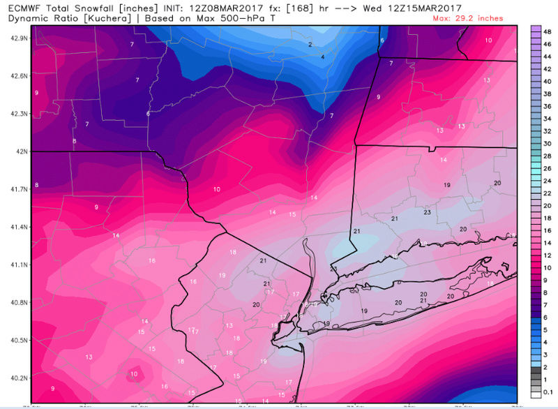
EURO snow map is madonne worthy.
nutleyblizzard- Senior Enthusiast
- Posts : 1954
Reputation : 41
Join date : 2014-01-30
Age : 58
Location : Nutley, new jersey
Re: Long Range Thread 13.0
![]() by amugs Wed Mar 08, 2017 2:15 pm
by amugs Wed Mar 08, 2017 2:15 pm

_________________
Mugs
AKA:King: Snow Weenie
Self Proclaimed
WINTER 2014-15 : 55.12" +.02 for 6 coatings (avg. 35")
WINTER 2015-16 Total - 29.8" (Avg 35")
WINTER 2016-17 : 39.5" so far

amugs- Advanced Forecaster - Mod
- Posts : 15095
Reputation : 213
Join date : 2013-01-07
Age : 54
Location : Hillsdale,NJ
Re: Long Range Thread 13.0
![]() by amugs Wed Mar 08, 2017 2:16 pm
by amugs Wed Mar 08, 2017 2:16 pm
_________________
Mugs
AKA:King: Snow Weenie
Self Proclaimed
WINTER 2014-15 : 55.12" +.02 for 6 coatings (avg. 35")
WINTER 2015-16 Total - 29.8" (Avg 35")
WINTER 2016-17 : 39.5" so far
amugs- Advanced Forecaster - Mod
- Posts : 15095
Reputation : 213
Join date : 2013-01-07
Age : 54
Location : Hillsdale,NJ
Re: Long Range Thread 13.0
![]() by SENJsnowman Wed Mar 08, 2017 2:18 pm
by SENJsnowman Wed Mar 08, 2017 2:18 pm
Frank_Wx wrote:
Help me out Frank...where is the R/S line here. Is it the 32 line, the lighter, thinner solid blue line, the last dotted blue line ...or somewhere in between? Thanks...
SENJsnowman- Senior Enthusiast
- Posts : 1189
Reputation : 61
Join date : 2017-01-06
Age : 51
Location : Bayville, NJ
Re: Long Range Thread 13.0
![]() by Frank_Wx Wed Mar 08, 2017 2:32 pm
by Frank_Wx Wed Mar 08, 2017 2:32 pm
SENJsnowman wrote:Frank_Wx wrote:
Help me out Frank...where is the R/S line here. Is it the 32 line, the lighter, thinner solid blue line, the last dotted blue line ...or somewhere in between? Thanks...
I prefer using the 850mb isotherm. Solid thin light blue line.
_________________
_______________________________________________________________________________________________________
CLICK HERE to view NJ Strong Snowstorm Classifications
Frank_Wx- Godzilla Seeker
- Posts : 21305
Reputation : 328
Join date : 2013-01-05
Age : 32
Location : Jersey City, NJ -
Re: Long Range Thread 13.0
![]() by sroc4 Wed Mar 08, 2017 2:33 pm
by sroc4 Wed Mar 08, 2017 2:33 pm
Notice the energy B is no longer strung out, but rather consolidated, and notice it is much further south when compared to 00z. This is likely the direct result of a much stronger and better positioned W Ridge/ Ridge axis.
Also look at energy D in the SW. The energy here is also further south. Now Im not sure how much this plays a role: ie: with the energy further N&W like the 00z euro does it act to undercut the southern portion of the W ridge; therefore, lead to a dampened Southern portion of the W Ridge, a more progressive flow, the more northerly track to energy B, and a more sheared out appearance to it because of the more progressive flow. And since Eneregy D is further S does it leave room for the W Ridge as a whole to amplify better? ORRR is energy D further S as a direct result of a better ridge? Either way you can see how close the GFS and Euro are.
The last thing to point out here is that what we have been calling wave two seems to get involved with the STJ such that the confluence of the N branch and the STJ out over the atlantic looks to funnel our S energy down the middle. Obv as the flow narrows down it slows therefore allowing the N branch energy A to dive into the backside of B and BOOM!
Lets get 24-48hrs of consistency here before we get too excited.
WE TRACK!!!

_________________
"In weather and in life, there's no winning and losing; there's only winning and learning."
WINTER 2012/2013 TOTALS 43.65"WINTER 2017/2018 TOTALS 62.85" WINTER 2022/2023 TOTALS 4.9"
WINTER 2013/2014 TOTALS 64.85"WINTER 2018/2019 TOTALS 14.25" WINTER 2023/2024 TOTALS 13.1"
WINTER 2014/2015 TOTALS 71.20"WINTER 2019/2020 TOTALS 6.35"
WINTER 2015/2016 TOTALS 35.00"WINTER 2020/2021 TOTALS 37.75"
WINTER 2016/2017 TOTALS 42.25"WINTER 2021/2022 TOTALS 31.65"
sroc4- Admin
- Posts : 8354
Reputation : 302
Join date : 2013-01-07
Location : Wading River, LI
Re: Long Range Thread 13.0
![]() by mikeypizano Wed Mar 08, 2017 2:34 pm
by mikeypizano Wed Mar 08, 2017 2:34 pm

mikeypizano- Pro Enthusiast

- Posts : 1118
Reputation : 66
Join date : 2017-01-05
Age : 35
Location : Wilkes-Barre/Scranton, PA
Re: Long Range Thread 13.0
![]() by jmanley32 Wed Mar 08, 2017 3:07 pm
by jmanley32 Wed Mar 08, 2017 3:07 pm
WOW, and wow to th snow map, big diff from the cut west from last night, I like Franks entusiasm as I do everyone elses here with the good knowledge, sounds like we could be in for a epicness storm as frank used the word not me. Of course yes one run but also to frank tuesday is less than a week away.Frank_Wx wrote:
jmanley32- Senior Enthusiast
- Posts : 20535
Reputation : 108
Join date : 2013-12-12
Age : 43
Location : Yonkers, NY
Page 37 of 40 • 1 ... 20 ... 36, 37, 38, 39, 40 ![]()
|
|
|