
 Search
Possible Snowstorm Thursday, February 9th
Page 10 of 26 •  1 ... 6 ... 9, 10, 11 ... 18 ... 26
 ![]()
Re: Possible Snowstorm Thursday, February 9th
![]() by algae888 Tue Feb 07, 2017 4:45 am
by algae888 Tue Feb 07, 2017 4:45 am
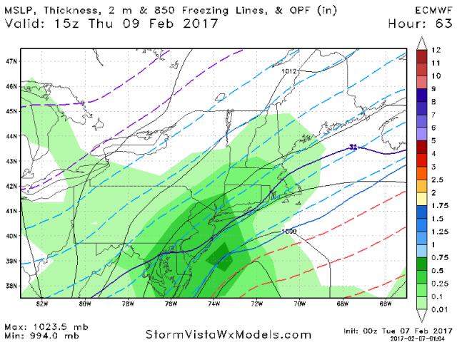
*Potential for the heaviest snowfall of the season so far for
the I95 and I78 corridors 05z-21z Thursday**
Hazards: None yet but contemplated a watch. But lack of model
consensus/forecaster confidence resulted in waiting another
forecast period before reconsidering a WATCH for the period 05z
/Thursday-21z Thursday. Timing of the snow/temperatures dropping
below freezing with the Thursday morning commute argues for
probable widespread Thursday morning delays, even if this not a
5 to 7 inch 12 hour warning event.
Thursday...Snow north and rain south changing to snow. Amounts
greatest I-78 region north and probably the largest snowfall of the
winter so far in parts of eastern Pa and northern NJ. cold. Snowfall
rates of an inch an hour possible during the morning in the
I78-180 region. As for the ending time...uncertainty. For now we
say snow ends south midday. Elsewhere in the north snow tapers
to flurries anytime early afternoon to sunset. Wind turns north
northwest and gusts 20-30 mph in the afternoon. Temperatures
steady or falling from 7am readings (calendar day highs at 1201AM).
algae888- Advanced Forecaster

- Posts : 5311
Join date : 2013-02-05
Re: Possible Snowstorm Thursday, February 9th
![]() by algae888 Tue Feb 07, 2017 4:52 am
by algae888 Tue Feb 07, 2017 4:52 am


algae888- Advanced Forecaster
- Posts : 5311
Join date : 2013-02-05
Re: Possible Snowstorm Thursday, February 9th
![]() by CPcantmeasuresnow Tue Feb 07, 2017 4:52 am
by CPcantmeasuresnow Tue Feb 07, 2017 4:52 am

CPcantmeasuresnow- Wx Statistician Guru

- Posts : 7274
Reputation : 230
Join date : 2013-01-07
Age : 103
Location : Eastern Orange County, NY
Re: Possible Snowstorm Thursday, February 9th
![]() by algae888 Tue Feb 07, 2017 4:55 am
by algae888 Tue Feb 07, 2017 4:55 am
"Attention will be on upstream trough, and eventual sfc low that is
forecast to develop to our southwest, and pass off the Mid Atlantic
coast, on Thu tracking toward or just south of the 40N/70W benchmark.
Have continued to discount the fast/flat GFS solution in favor of a
more amplified a la ECMWF/SREF mean blend. NAM appears too
amplified, and appears much too wet.
It still looks like will rain move in ahead of the approaching low
Wed night. then we will see a transition to snow from NW to SE to
snow as colder air moves in north of the developing low.
An overall snowfall of at least 4-6 inches appears likely, with
the highest amounts over central/eastern Long Island and
southern CT. Position of heaviest snow bands remains in
question, and could well shift north of here. The probabilistic
snowfall forecast will reflect this as well as potential for
amounts of 6-8 inches in the higher percentile categories, not
to be taken lightly since snowfall totals have pushed the 90th
percentile with almost every winter weather event this season."
wow what a difference a few days make in the world of weather. off
to bed to get ready for the 12z runs...

algae888- Advanced Forecaster
- Posts : 5311
Reputation : 46
Join date : 2013-02-05
Age : 61
Location : mt. vernon, new york
Re: Possible Snowstorm Thursday, February 9th
![]() by CPcantmeasuresnow Tue Feb 07, 2017 5:07 am
by CPcantmeasuresnow Tue Feb 07, 2017 5:07 am
CPcantmeasuresnow wrote:Guess they're liking the NAM. The 6z would make just about our entire forum happy. 9 inches over Skins, 10 over NYC, 12 over SYOS, 11 over mugs and Janet and 15 over Doc and HV. To good to be true but it's been pretty consistent and if anything trending stronger run to run. Still no model agreement but EURO trended stronger overnight and UKMET so who knows. We still can't bet on anything till this energy is over land and we have better samples but as you posted AL NWS is starting to believe which is early in the game for them.
Add the 6Z GFS to the party. Mothrazilla from CNJ through LHV and all of NYC AND LI. Wish it was tomorrow morning.
CPcantmeasuresnow- Wx Statistician Guru
- Posts : 7274
Reputation : 230
Join date : 2013-01-07
Age : 103
Location : Eastern Orange County, NY
Re: Possible Snowstorm Thursday, February 9th
![]() by skinsfan1177 Tue Feb 07, 2017 5:15 am
by skinsfan1177 Tue Feb 07, 2017 5:15 am

skinsfan1177- Senior Enthusiast

- Posts : 4485
Reputation : 35
Join date : 2013-01-07
Age : 46
Location : Point Pleasant Boro
Re: Possible Snowstorm Thursday, February 9th
![]() by Frank_Wx Tue Feb 07, 2017 5:52 am
by Frank_Wx Tue Feb 07, 2017 5:52 am

_________________
_______________________________________________________________________________________________________
CLICK HERE to view NJ Strong Snowstorm Classifications

Frank_Wx- Godzilla Seeker

- Posts : 21305
Reputation : 328
Join date : 2013-01-05
Age : 31
Location : Jersey City, NJ -

Re: Possible Snowstorm Thursday, February 9th
![]() by skinsfan1177 Tue Feb 07, 2017 6:18 am
by skinsfan1177 Tue Feb 07, 2017 6:18 am

skinsfan1177- Senior Enthusiast
- Posts : 4485
Reputation : 35
Join date : 2013-01-07
Age : 46
Location : Point Pleasant Boro
Re: Possible Snowstorm Thursday, February 9th
![]() by docstox12 Tue Feb 07, 2017 6:39 am
by docstox12 Tue Feb 07, 2017 6:39 am
CPcantmeasuresnow wrote:Guess they're liking the NAM. The 6z would make just about our entire forum happy. 9 inches over Skins, 10 over NYC, 12 over SYOS, 11 over mugs and Janet and 15 over Doc and HV. To good to be true but it's been pretty consistent and if anything trending stronger run to run. Still no model agreement but EURO trended stronger overnight and UKMET so who knows. We still can't bet on anything till this energy is over land and we have better samples but as you posted AL NWS is starting to believe which is early in the game for them.
Sorry, CP, not buying this at all.NWS says LI and Southern Connecticut will be hardest hit as usual.Let's hope colder temps here give us a good ration so we get the 3 to 7 they predict.Skins posted the latest euro showing the coast gets hit the hardest.I believe that one will play out with the S and E trends of recent years on these coastal systems.

docstox12- Wx Statistician Guru
- Posts : 8504
Reputation : 222
Join date : 2013-01-07
Age : 73
Location : Monroe NY
Re: Possible Snowstorm Thursday, February 9th
![]() by skinsfan1177 Tue Feb 07, 2017 6:43 am
by skinsfan1177 Tue Feb 07, 2017 6:43 am
docstox12 wrote:CPcantmeasuresnow wrote:Guess they're liking the NAM. The 6z would make just about our entire forum happy. 9 inches over Skins, 10 over NYC, 12 over SYOS, 11 over mugs and Janet and 15 over Doc and HV. To good to be true but it's been pretty consistent and if anything trending stronger run to run. Still no model agreement but EURO trended stronger overnight and UKMET so who knows. We still can't bet on anything till this energy is over land and we have better samples but as you posted AL NWS is starting to believe which is early in the game for them.
Sorry, CP, not buying this at all.NWS says LI and Southern Connecticut will be hardest hit as usual.Let's hope colder temps here give us a good ration so we get the 3 to 7 they predict.Skins posted the latest euro showing the coast gets hit the hardest.I believe that one will play out with the S and E trends of recent years on these coastal systems.
Doc I hope we all cash in with this many think the nam is overamped
skinsfan1177- Senior Enthusiast
- Posts : 4485
Reputation : 35
Join date : 2013-01-07
Age : 46
Location : Point Pleasant Boro
Re: Possible Snowstorm Thursday, February 9th
![]() by CPcantmeasuresnow Tue Feb 07, 2017 6:46 am
by CPcantmeasuresnow Tue Feb 07, 2017 6:46 am
docstox12 wrote:CPcantmeasuresnow wrote:Guess they're liking the NAM. The 6z would make just about our entire forum happy. 9 inches over Skins, 10 over NYC, 12 over SYOS, 11 over mugs and Janet and 15 over Doc and HV. To good to be true but it's been pretty consistent and if anything trending stronger run to run. Still no model agreement but EURO trended stronger overnight and UKMET so who knows. We still can't bet on anything till this energy is over land and we have better samples but as you posted AL NWS is starting to believe which is early in the game for them.
Sorry, CP, not buying this at all.NWS says LI and Southern Connecticut will be hardest hit as usual.Let's hope colder temps here give us a good ration so we get the 3 to 7 they predict.Skins posted the latest euro showing the coast gets hit the hardest.I believe that one will play out with the S and E trends of recent years on these coastal systems.
Not buying it on this one Doc, not yet at least, not enough sampling of the energy yet inthe pacific so who knows. Anything goes at this point.
CPcantmeasuresnow- Wx Statistician Guru
- Posts : 7274
Reputation : 230
Join date : 2013-01-07
Age : 103
Location : Eastern Orange County, NY
Re: Possible Snowstorm Thursday, February 9th
![]() by docstox12 Tue Feb 07, 2017 6:50 am
by docstox12 Tue Feb 07, 2017 6:50 am
skinsfan1177 wrote:docstox12 wrote:CPcantmeasuresnow wrote:Guess they're liking the NAM. The 6z would make just about our entire forum happy. 9 inches over Skins, 10 over NYC, 12 over SYOS, 11 over mugs and Janet and 15 over Doc and HV. To good to be true but it's been pretty consistent and if anything trending stronger run to run. Still no model agreement but EURO trended stronger overnight and UKMET so who knows. We still can't bet on anything till this energy is over land and we have better samples but as you posted AL NWS is starting to believe which is early in the game for them.
Sorry, CP, not buying this at all.NWS says LI and Southern Connecticut will be hardest hit as usual.Let's hope colder temps here give us a good ration so we get the 3 to 7 they predict.Skins posted the latest euro showing the coast gets hit the hardest.I believe that one will play out with the S and E trends of recent years on these coastal systems.
Doc I hope we all cash in with this many think the nam is overamped
OK, Skins, lets see how it all plays out.I agree on that Nam.Tomorrow morning should make it all a lot clearer.
docstox12- Wx Statistician Guru
- Posts : 8504
Reputation : 222
Join date : 2013-01-07
Age : 73
Location : Monroe NY
Re: Possible Snowstorm Thursday, February 9th
![]() by docstox12 Tue Feb 07, 2017 6:51 am
by docstox12 Tue Feb 07, 2017 6:51 am
CPcantmeasuresnow wrote:docstox12 wrote:CPcantmeasuresnow wrote:Guess they're liking the NAM. The 6z would make just about our entire forum happy. 9 inches over Skins, 10 over NYC, 12 over SYOS, 11 over mugs and Janet and 15 over Doc and HV. To good to be true but it's been pretty consistent and if anything trending stronger run to run. Still no model agreement but EURO trended stronger overnight and UKMET so who knows. We still can't bet on anything till this energy is over land and we have better samples but as you posted AL NWS is starting to believe which is early in the game for them.
Sorry, CP, not buying this at all.NWS says LI and Southern Connecticut will be hardest hit as usual.Let's hope colder temps here give us a good ration so we get the 3 to 7 they predict.Skins posted the latest euro showing the coast gets hit the hardest.I believe that one will play out with the S and E trends of recent years on these coastal systems.
Not buying it on this one Doc, not yet at least, not enough sampling of the energy yet inthe pacific so who knows. Anything goes at this point.
CP, I'll be happy with that NWS forecast of 3 to 7.
docstox12- Wx Statistician Guru
- Posts : 8504
Reputation : 222
Join date : 2013-01-07
Age : 73
Location : Monroe NY
Re: Possible Snowstorm Thursday, February 9th
![]() by Frank_Wx Tue Feb 07, 2017 7:12 am
by Frank_Wx Tue Feb 07, 2017 7:12 am
http://www.nycareaweather.com/archives/february-3-2014/
_________________
_______________________________________________________________________________________________________
CLICK HERE to view NJ Strong Snowstorm Classifications
Frank_Wx- Godzilla Seeker
- Posts : 21305
Reputation : 328
Join date : 2013-01-05
Age : 31
Location : Jersey City, NJ -
Re: Possible Snowstorm Thursday, February 9th
![]() by sroc4 Tue Feb 07, 2017 7:21 am
by sroc4 Tue Feb 07, 2017 7:21 am
_________________
"In weather and in life, there's no winning and losing; there's only winning and learning."
WINTER 2012/2013 TOTALS 43.65"WINTER 2017/2018 TOTALS 62.85" WINTER 2022/2023 TOTALS 4.9"
WINTER 2013/2014 TOTALS 64.85"WINTER 2018/2019 TOTALS 14.25" WINTER 2023/2024 TOTALS 13.1"
WINTER 2014/2015 TOTALS 71.20"WINTER 2019/2020 TOTALS 6.35"
WINTER 2015/2016 TOTALS 35.00"WINTER 2020/2021 TOTALS 37.75"
WINTER 2016/2017 TOTALS 42.25"WINTER 2021/2022 TOTALS 31.65"

sroc4- Admin
- Posts : 8331
Reputation : 301
Join date : 2013-01-07
Location : Wading River, LI
Re: Possible Snowstorm Thursday, February 9th
![]() by jmanley32 Tue Feb 07, 2017 7:38 am
by jmanley32 Tue Feb 07, 2017 7:38 am

jmanley32- Senior Enthusiast
- Posts : 20516
Reputation : 108
Join date : 2013-12-12
Age : 42
Location : Yonkers, NY
Re: Possible Snowstorm Thursday, February 9th
![]() by jmanley32 Tue Feb 07, 2017 7:39 am
by jmanley32 Tue Feb 07, 2017 7:39 am
I followed this guy for years before he got fickle in his updates sometimes going weeks or even months not updating, very good and answers your emails but then I found this place : )Frank_Wx wrote:Here is the CIPS analog for this storm
http://www.nycareaweather.com/archives/february-3-2014/
jmanley32- Senior Enthusiast
- Posts : 20516
Reputation : 108
Join date : 2013-12-12
Age : 42
Location : Yonkers, NY
Re: Possible Snowstorm Thursday, February 9th
![]() by jmanley32 Tue Feb 07, 2017 7:41 am
by jmanley32 Tue Feb 07, 2017 7:41 am
jmanley32- Senior Enthusiast
- Posts : 20516
Reputation : 108
Join date : 2013-12-12
Age : 42
Location : Yonkers, NY
Re: Possible Snowstorm Thursday, February 9th
![]() by Guest Tue Feb 07, 2017 7:58 am
by Guest Tue Feb 07, 2017 7:58 am
Guest- Guest
Re: Possible Snowstorm Thursday, February 9th
![]() by rb924119 Tue Feb 07, 2017 8:11 am
by rb924119 Tue Feb 07, 2017 8:11 am
rb924119- Meteorologist

- Posts : 6890
Reputation : 194
Join date : 2013-02-06
Age : 32
Location : Greentown, Pa
Re: Possible Snowstorm Thursday, February 9th
![]() by amugs Tue Feb 07, 2017 8:27 am
by amugs Tue Feb 07, 2017 8:27 am
rb924119 wrote:I don't understand why the NWS is discounting the NAM. Given the jet structures, I personally find it entirely plausible and actually a bit more likely than the others right now.
They are tards for gods sake - look at the SREFS!!!!!!!!!!!!!!!!!
MECS BABY!!!!

MOMMA MIA !!!!!!!!!

_________________
Mugs
AKA:King: Snow Weenie
Self Proclaimed
WINTER 2014-15 : 55.12" +.02 for 6 coatings (avg. 35")
WINTER 2015-16 Total - 29.8" (Avg 35")
WINTER 2016-17 : 39.5" so far

amugs- Advanced Forecaster - Mod

- Posts : 15093
Reputation : 213
Join date : 2013-01-07
Age : 54
Location : Hillsdale,NJ
Re: Possible Snowstorm Thursday, February 9th
![]() by skinsfan1177 Tue Feb 07, 2017 8:30 am
by skinsfan1177 Tue Feb 07, 2017 8:30 am
skinsfan1177- Senior Enthusiast
- Posts : 4485
Reputation : 35
Join date : 2013-01-07
Age : 46
Location : Point Pleasant Boro
Re: Possible Snowstorm Thursday, February 9th
![]() by amugs Tue Feb 07, 2017 8:33 am
by amugs Tue Feb 07, 2017 8:33 am
syosnow94 wrote:My main concern about Thursday is the temperatures. 60 degrees tomorrow afternoon would mean we would have to drop about 30 degrees in 12 hours!
Chill it is an arctic front (a banana high) once it gets past you temps will crash like a rock falling out of a 2nd story window - jesus you are worry wort!
You are going to be in a prime spot for snow agai. May start as rain but it will quickly change over to snow.
_________________
Mugs
AKA:King: Snow Weenie
Self Proclaimed
WINTER 2014-15 : 55.12" +.02 for 6 coatings (avg. 35")
WINTER 2015-16 Total - 29.8" (Avg 35")
WINTER 2016-17 : 39.5" so far
amugs- Advanced Forecaster - Mod
- Posts : 15093
Reputation : 213
Join date : 2013-01-07
Age : 54
Location : Hillsdale,NJ
Re: Possible Snowstorm Thursday, February 9th
![]() by amugs Tue Feb 07, 2017 8:36 am
by amugs Tue Feb 07, 2017 8:36 am

_________________
Mugs
AKA:King: Snow Weenie
Self Proclaimed
WINTER 2014-15 : 55.12" +.02 for 6 coatings (avg. 35")
WINTER 2015-16 Total - 29.8" (Avg 35")
WINTER 2016-17 : 39.5" so far
amugs- Advanced Forecaster - Mod
- Posts : 15093
Reputation : 213
Join date : 2013-01-07
Age : 54
Location : Hillsdale,NJ
Re: Possible Snowstorm Thursday, February 9th
![]() by skinsfan1177 Tue Feb 07, 2017 8:43 am
by skinsfan1177 Tue Feb 07, 2017 8:43 am
amugs wrote:Are u FN kidding me SKINS and Ace - I swear I hope it rains instead of snow - LOL!! South will have mixing issues - where that line sets up will be probably just below Monmouth cty if I had to guess at this time looking at the data. COuld push down to ACY as per JB thoughts.
Mugsy relax I was asking and to your point is because it's a close call for my area
skinsfan1177- Senior Enthusiast
- Posts : 4485
Reputation : 35
Join date : 2013-01-07
Age : 46
Location : Point Pleasant Boro
Re: Possible Snowstorm Thursday, February 9th
![]() by CPcantmeasuresnow Tue Feb 07, 2017 8:44 am
by CPcantmeasuresnow Tue Feb 07, 2017 8:44 am
amugs wrote:rb924119 wrote:I don't understand why the NWS is discounting the NAM. Given the jet structures, I personally find it entirely plausible and actually a bit more likely than the others right now.
They are tards for gods sake - look at the SREFS!!!!!!!!!!!!!!!!!
MECS BABY!!!!
MOMMA MIA !!!!!!!!!
Maybe not a MECS but a high end Mothrazilla for all. I'll take it.
CPcantmeasuresnow- Wx Statistician Guru
- Posts : 7274
Reputation : 230
Join date : 2013-01-07
Age : 103
Location : Eastern Orange County, NY
Re: Possible Snowstorm Thursday, February 9th
![]() by SNOW MAN Tue Feb 07, 2017 8:46 am
by SNOW MAN Tue Feb 07, 2017 8:46 am

SNOW MAN- Senior Enthusiast
- Posts : 1361
Reputation : 25
Join date : 2013-01-13
Age : 64
Location : Marshalls Creek Pa.
Page 10 of 26 • 1 ... 6 ... 9, 10, 11 ... 18 ... 26 ![]()
|
|
|