
 Search
March 14, 2017 Roidzilla 1st Call Snow Map / Synopsis
Page 10 of 33 •  1 ... 6 ... 9, 10, 11 ... 21 ... 33
 ![]()
Re: March 14, 2017 Roidzilla 1st Call Snow Map / Synopsis
![]() by SoulSingMG Mon Mar 13, 2017 2:15 am
by SoulSingMG Mon Mar 13, 2017 2:15 am
jmanley32 wrote:As cp said they should have already. Personally I font think there's go b long enough mix issue to not have blizzard.
We'll see. I'm not liking this too close for comfort hugger aspect to the storm but I also can't remember a mid 970's storm hanging out just east of us. So I don't know honestly.
SoulSingMG- Senior Enthusiast

- Posts : 2853
Join date : 2013-12-11
Re: March 14, 2017 Roidzilla 1st Call Snow Map / Synopsis
![]() by CPcantmeasuresnow Mon Mar 13, 2017 2:18 am
by CPcantmeasuresnow Mon Mar 13, 2017 2:18 am

CPcantmeasuresnow- Wx Statistician Guru

- Posts : 7274
Join date : 2013-01-07
Re: March 14, 2017 Roidzilla 1st Call Snow Map / Synopsis
![]() by CPcantmeasuresnow Mon Mar 13, 2017 2:20 am
by CPcantmeasuresnow Mon Mar 13, 2017 2:20 am
Hopefully we start trending a little bit east tomorrow, but not too much east.
Last edited by CPcantmeasuresnow on Mon Mar 13, 2017 2:22 am; edited 1 time in total

CPcantmeasuresnow- Wx Statistician Guru
- Posts : 7274
Reputation : 230
Join date : 2013-01-07
Age : 103
Location : Eastern Orange County, NY
Re: March 14, 2017 Roidzilla 1st Call Snow Map / Synopsis
![]() by Snow88 Mon Mar 13, 2017 2:22 am
by Snow88 Mon Mar 13, 2017 2:22 am
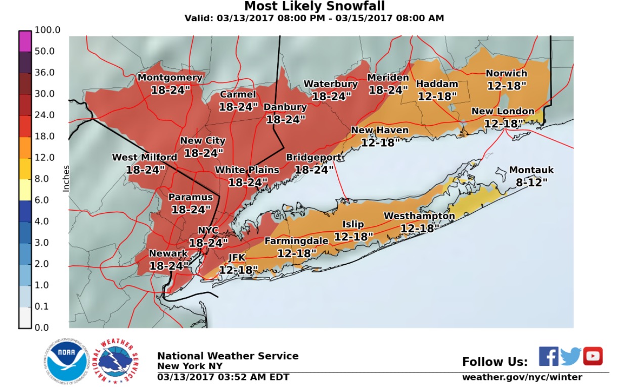
10-15 inches for NYC with a lot more to the west
Freezing line when the city changes to rain is just to the west so we still have to monitor this storm
Any wobbles to the west or east will be big on the models

Snow88- Senior Enthusiast
- Posts : 2193
Reputation : 4
Join date : 2013-01-09
Age : 35
Location : Brooklyn, NY
Re: March 14, 2017 Roidzilla 1st Call Snow Map / Synopsis
![]() by jmanley32 Mon Mar 13, 2017 4:25 am
by jmanley32 Mon Mar 13, 2017 4:25 am

jmanley32- Senior Enthusiast
- Posts : 20516
Reputation : 108
Join date : 2013-12-12
Age : 42
Location : Yonkers, NY
Re: March 14, 2017 Roidzilla 1st Call Snow Map / Synopsis
![]() by pdubz Mon Mar 13, 2017 4:54 am
by pdubz Mon Mar 13, 2017 4:54 am

pdubz- Pro Enthusiast

- Posts : 539
Reputation : 0
Join date : 2013-09-24
Age : 32
Location : Port Washington,NY (L.I)
Re: March 14, 2017 Roidzilla 1st Call Snow Map / Synopsis
![]() by 2004blackwrx Mon Mar 13, 2017 4:57 am
by 2004blackwrx Mon Mar 13, 2017 4:57 am
2004blackwrx- Pro Enthusiast
- Posts : 576
Reputation : 9
Join date : 2013-01-14
Location : Wappinger NY
Re: March 14, 2017 Roidzilla 1st Call Snow Map / Synopsis
![]() by skinsfan1177 Mon Mar 13, 2017 5:13 am
by skinsfan1177 Mon Mar 13, 2017 5:13 am

skinsfan1177- Senior Enthusiast
- Posts : 4485
Reputation : 35
Join date : 2013-01-07
Age : 46
Location : Point Pleasant Boro
Re: March 14, 2017 Roidzilla 1st Call Snow Map / Synopsis
![]() by skinsfan1177 Mon Mar 13, 2017 5:24 am
by skinsfan1177 Mon Mar 13, 2017 5:24 am
skinsfan1177- Senior Enthusiast
- Posts : 4485
Reputation : 35
Join date : 2013-01-07
Age : 46
Location : Point Pleasant Boro
Re: March 14, 2017 Roidzilla 1st Call Snow Map / Synopsis
![]() by docstox12 Mon Mar 13, 2017 5:41 am
by docstox12 Mon Mar 13, 2017 5:41 am
skinsfan1177 wrote:3k nam I'm rolling with it.
There ya go Skins, looking good for AREA WIDE snowstorm every run.
4 degrees.All this attention on the snowstorm but we have had three nights in a row in the single digits up here.This is late January weather!Cold air locked and loaded.

docstox12- Wx Statistician Guru
- Posts : 8506
Reputation : 222
Join date : 2013-01-07
Age : 73
Location : Monroe NY
Re: March 14, 2017 Roidzilla 1st Call Snow Map / Synopsis
![]() by track17 Mon Mar 13, 2017 5:49 am
by track17 Mon Mar 13, 2017 5:49 am
track17- Posts : 454
Reputation : 4
Join date : 2016-01-09
Re: March 14, 2017 Roidzilla 1st Call Snow Map / Synopsis
![]() by Frank_Wx Mon Mar 13, 2017 5:52 am
by Frank_Wx Mon Mar 13, 2017 5:52 am

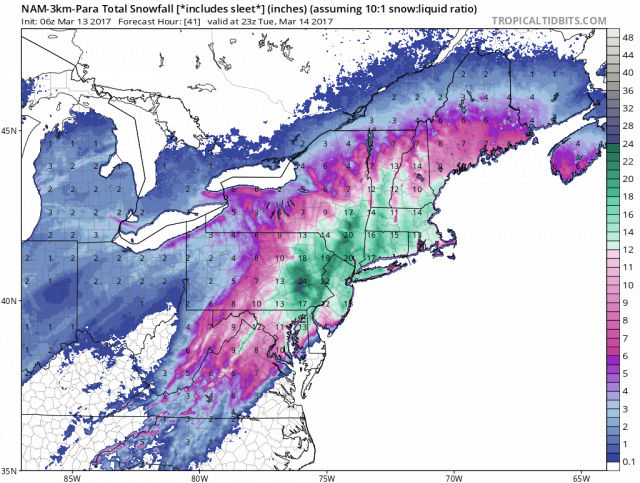
06z NAM

3z SREFS

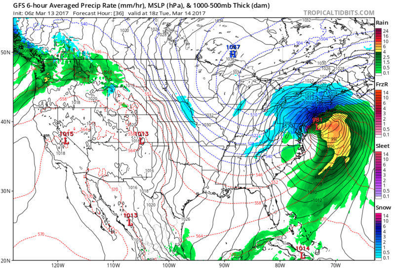
06z GFS

_________________
_______________________________________________________________________________________________________
CLICK HERE to view NJ Strong Snowstorm Classifications

Frank_Wx- Godzilla Seeker

- Posts : 21305
Reputation : 328
Join date : 2013-01-05
Age : 31
Location : Jersey City, NJ -

Re: March 14, 2017 Roidzilla 1st Call Snow Map / Synopsis
![]() by frank 638 Mon Mar 13, 2017 5:54 am
by frank 638 Mon Mar 13, 2017 5:54 am
frank 638- Senior Enthusiast
- Posts : 2825
Reputation : 37
Join date : 2016-01-01
Age : 40
Location : bronx ny
Re: March 14, 2017 Roidzilla 1st Call Snow Map / Synopsis
![]() by Frank_Wx Mon Mar 13, 2017 5:55 am
by Frank_Wx Mon Mar 13, 2017 5:55 am

UKMET

Euro

_________________
_______________________________________________________________________________________________________
CLICK HERE to view NJ Strong Snowstorm Classifications
Frank_Wx- Godzilla Seeker
- Posts : 21305
Reputation : 328
Join date : 2013-01-05
Age : 31
Location : Jersey City, NJ -
Re: March 14, 2017 Roidzilla 1st Call Snow Map / Synopsis
![]() by SNOW MAN Mon Mar 13, 2017 5:56 am
by SNOW MAN Mon Mar 13, 2017 5:56 am
Looks like we're in for a doozy of a storm. I'm hoping my work will be closed tomorrow. They closed for the last storm which doesn't even compare to this one. It's not like I was even going attempt to go in. I can't see myself driving 62 miles in a raging snow storm. I'm to old for that crap. I don't think I'll be getting to much done today at work because I'll probably be checking this forum constantly. LOL !!!

SNOW MAN- Senior Enthusiast
- Posts : 1361
Reputation : 25
Join date : 2013-01-13
Age : 64
Location : Marshalls Creek Pa.
Re: March 14, 2017 Roidzilla 1st Call Snow Map / Synopsis
![]() by Frank_Wx Mon Mar 13, 2017 5:56 am
by Frank_Wx Mon Mar 13, 2017 5:56 am
http://wx.aerisweather.com/maps/severe/warnings/all/usnj.html
_________________
_______________________________________________________________________________________________________
CLICK HERE to view NJ Strong Snowstorm Classifications
Frank_Wx- Godzilla Seeker
- Posts : 21305
Reputation : 328
Join date : 2013-01-05
Age : 31
Location : Jersey City, NJ -
Re: March 14, 2017 Roidzilla 1st Call Snow Map / Synopsis
![]() by Frank_Wx Mon Mar 13, 2017 5:57 am
by Frank_Wx Mon Mar 13, 2017 5:57 am
418 AM EDT Mon Mar 13 2017
...BLIZZARD WARNING IN EFFECT FROM MIDNIGHT TONIGHT TO MIDNIGHT
EDT TUESDAY NIGHT...
The National Weather Service in Upton has issued a Blizzard
Warning, which is in effect from midnight tonight to midnight EDT
Tuesday night. The Blizzard Watch is no longer in effect.
* Locations...Metropolitan New York City and New Jersey, Western
Long Island, Southern Westchester, Southern Fairfield, Southern
New Haven, Northern Middlesex, and Northern New London
counties.
* Hazard Types...Heavy Snow and Blizzard Conditions. Snow may mix
with or change to sleet and rain across southern and eastern
coastal areas late Tuesday morning into Tuesday afternoon.
* Snow Accumulations...12 to 20 inches...highest amounts to the
north and west.
* Snowfall Rates...2 to 4 inches per hour early Tuesday morning
into early Tuesday afternoon.
* Timing...Late tonight into Tuesday evening.
* Impacts...Dangerous travel due to whiteout conditions at times.
Several roads may become impassable. Power outages possible.
Damaging wind gusts possible across Long Island and coastal
Connecticut.
* Winds...Northeast 25 to 35 mph with gusts 40 to 55 mph on
Tuesday. Highest winds across coastal areas.
* Temperatures...In the upper 20s.
* Visibilities...One quarter mile or less at times.
PRECAUTIONARY/PREPAREDNESS ACTIONS...
A Blizzard Warning means severe winter weather conditions are
expected or occurring. Falling and blowing snow with strong winds
and poor visibilities are likely. This will lead to whiteout
conditions...making travel extremely dangerous. Do not travel. If
you must travel...have a winter survival kit with you. If you get
stranded...stay with your vehicle.
_________________
_______________________________________________________________________________________________________
CLICK HERE to view NJ Strong Snowstorm Classifications
Frank_Wx- Godzilla Seeker
- Posts : 21305
Reputation : 328
Join date : 2013-01-05
Age : 31
Location : Jersey City, NJ -
Re: March 14, 2017 Roidzilla 1st Call Snow Map / Synopsis
![]() by Frank_Wx Mon Mar 13, 2017 6:02 am
by Frank_Wx Mon Mar 13, 2017 6:02 am
_________________
_______________________________________________________________________________________________________
CLICK HERE to view NJ Strong Snowstorm Classifications
Frank_Wx- Godzilla Seeker
- Posts : 21305
Reputation : 328
Join date : 2013-01-05
Age : 31
Location : Jersey City, NJ -
Re: March 14, 2017 Roidzilla 1st Call Snow Map / Synopsis
![]() by nutleyblizzard Mon Mar 13, 2017 6:04 am
by nutleyblizzard Mon Mar 13, 2017 6:04 am
6z GFS is a crusher for NYC Metro!

nutleyblizzard- Senior Enthusiast
- Posts : 1952
Reputation : 41
Join date : 2014-01-30
Age : 58
Location : Nutley, new jersey
Re: March 14, 2017 Roidzilla 1st Call Snow Map / Synopsis
![]() by mikeypizano Mon Mar 13, 2017 6:09 am
by mikeypizano Mon Mar 13, 2017 6:09 am

mikeypizano- Pro Enthusiast
- Posts : 1118
Reputation : 66
Join date : 2017-01-05
Age : 35
Location : Wilkes-Barre/Scranton, PA
Re: March 14, 2017 Roidzilla 1st Call Snow Map / Synopsis
![]() by docstox12 Mon Mar 13, 2017 6:11 am
by docstox12 Mon Mar 13, 2017 6:11 am
SNOW MAN wrote:Good morning Doc. Holy crap I'm tired. I think I've had about 6 hours sleep in the last two nights. Plus losing the hour isn't helping. This board is like a magnet it just pulls you in and you can't get away. My wife is on the verge of kicking me out. LOL ! She just isn't a full fledged Snow Weenie like all of us on here, but she does like snow. But not the cleaning up part.
Looks like we're in for a doozy of a storm. I'm hoping my work will be closed tomorrow. They closed for the last storm which doesn't even compare to this one. It's not like I was even going attempt to go in. I can't see myself driving 62 miles in a raging snow storm. I'm to old for that crap. I don't think I'll be getting to much done today at work because I'll probably be checking this forum constantly. LOL !!!
Good Morning SNOW MAN. Yep, it sure has been a blast the last few days on the board, it has really come alive with the excitement of the coming storm.LOL, I think CP's wife has him in the doghouse too! Anyway, it's looking better and better for us N and W folks on the board as this thing is west of the BM right now.I hope you are off tomorrow becasue we are gonna have a BLAST sending in reports on the storm's progress.
docstox12- Wx Statistician Guru
- Posts : 8506
Reputation : 222
Join date : 2013-01-07
Age : 73
Location : Monroe NY
Re: March 14, 2017 Roidzilla 1st Call Snow Map / Synopsis
![]() by docstox12 Mon Mar 13, 2017 6:14 am
by docstox12 Mon Mar 13, 2017 6:14 am
Frank_Wx wrote:418 AM EDT Mon Mar 13 2017
...BLIZZARD WARNING IN EFFECT FROM MIDNIGHT TONIGHT TO MIDNIGHT
EDT TUESDAY NIGHT...
The National Weather Service in Upton has issued a Blizzard
Warning, which is in effect from midnight tonight to midnight EDT
Tuesday night. The Blizzard Watch is no longer in effect.
* Locations...Metropolitan New York City and New Jersey, Western
Long Island, Southern Westchester, Southern Fairfield, Southern
New Haven, Northern Middlesex, and Northern New London
counties.
* Hazard Types...Heavy Snow and Blizzard Conditions. Snow may mix
with or change to sleet and rain across southern and eastern
coastal areas late Tuesday morning into Tuesday afternoon.
* Snow Accumulations...12 to 20 inches...highest amounts to the
north and west.
* Snowfall Rates...2 to 4 inches per hour early Tuesday morning
into early Tuesday afternoon.
* Timing...Late tonight into Tuesday evening.
* Impacts...Dangerous travel due to whiteout conditions at times.
Several roads may become impassable. Power outages possible.
Damaging wind gusts possible across Long Island and coastal
Connecticut.
* Winds...Northeast 25 to 35 mph with gusts 40 to 55 mph on
Tuesday. Highest winds across coastal areas.
* Temperatures...In the upper 20s.
* Visibilities...One quarter mile or less at times.
PRECAUTIONARY/PREPAREDNESS ACTIONS...
A Blizzard Warning means severe winter weather conditions are
expected or occurring. Falling and blowing snow with strong winds
and poor visibilities are likely. This will lead to whiteout
conditions...making travel extremely dangerous. Do not travel. If
you must travel...have a winter survival kit with you. If you get
stranded...stay with your vehicle.
Wow, that report could have come from 1967 not 2017 with the 'more amounts to the N and W comment' which was standard operating procedure in those days.Living in Fort Lee NJ at the time, you always were biting your nails as mix was always mentioned in the forecast.Even in the huge Feb 1961 snowstorm, it went over to a mix, but just for a half hour or less.January 1978 blizzard the mix line got to Newark and stopped.You never were sure in those days as the storm tracks always had mixes in the MIX,LOL.
docstox12- Wx Statistician Guru
- Posts : 8506
Reputation : 222
Join date : 2013-01-07
Age : 73
Location : Monroe NY
Re: March 14, 2017 Roidzilla 1st Call Snow Map / Synopsis
![]() by SNOW MAN Mon Mar 13, 2017 6:20 am
by SNOW MAN Mon Mar 13, 2017 6:20 am
docstox12 wrote:Frank_Wx wrote:418 AM EDT Mon Mar 13 2017
...BLIZZARD WARNING IN EFFECT FROM MIDNIGHT TONIGHT TO MIDNIGHT
EDT TUESDAY NIGHT...
The National Weather Service in Upton has issued a Blizzard
Warning, which is in effect from midnight tonight to midnight EDT
Tuesday night. The Blizzard Watch is no longer in effect.
* Locations...Metropolitan New York City and New Jersey, Western
Long Island, Southern Westchester, Southern Fairfield, Southern
New Haven, Northern Middlesex, and Northern New London
counties.
* Hazard Types...Heavy Snow and Blizzard Conditions. Snow may mix
with or change to sleet and rain across southern and eastern
coastal areas late Tuesday morning into Tuesday afternoon.
* Snow Accumulations...12 to 20 inches...highest amounts to the
north and west.
* Snowfall Rates...2 to 4 inches per hour early Tuesday morning
into early Tuesday afternoon.
* Timing...Late tonight into Tuesday evening.
* Impacts...Dangerous travel due to whiteout conditions at times.
Several roads may become impassable. Power outages possible.
Damaging wind gusts possible across Long Island and coastal
Connecticut.
* Winds...Northeast 25 to 35 mph with gusts 40 to 55 mph on
Tuesday. Highest winds across coastal areas.
* Temperatures...In the upper 20s.
* Visibilities...One quarter mile or less at times.
PRECAUTIONARY/PREPAREDNESS ACTIONS...
A Blizzard Warning means severe winter weather conditions are
expected or occurring. Falling and blowing snow with strong winds
and poor visibilities are likely. This will lead to whiteout
conditions...making travel extremely dangerous. Do not travel. If
you must travel...have a winter survival kit with you. If you get
stranded...stay with your vehicle.
Wow, that report could have come from 1967 not 2017 with the 'more amounts to the N and W comment' which was standard operating procedure in those days.Living in Fort Lee NJ at the time, you always were biting your nails as mix was always mentioned in the forecast.Even in the huge Feb 1961 snowstorm, it went over to a mix, but just for a half hour or less.January 1978 blizzard the mix line got to Newark and stopped.You never were sure in those days as the storm tracks always had mixes in the MIX,LOL.
Doc your like a walking talking history book.
Last edited by SNOW MAN on Mon Mar 13, 2017 6:20 am; edited 1 time in total
SNOW MAN- Senior Enthusiast
- Posts : 1361
Reputation : 25
Join date : 2013-01-13
Age : 64
Location : Marshalls Creek Pa.
Re: March 14, 2017 Roidzilla 1st Call Snow Map / Synopsis
![]() by Guest Mon Mar 13, 2017 6:20 am
by Guest Mon Mar 13, 2017 6:20 am
Guest- Guest
Re: March 14, 2017 Roidzilla 1st Call Snow Map / Synopsis
![]() by track17 Mon Mar 13, 2017 6:22 am
by track17 Mon Mar 13, 2017 6:22 am
track17- Posts : 454
Reputation : 4
Join date : 2016-01-09
Re: March 14, 2017 Roidzilla 1st Call Snow Map / Synopsis
![]() by 2004blackwrx Mon Mar 13, 2017 6:24 am
by 2004blackwrx Mon Mar 13, 2017 6:24 am
2004blackwrx- Pro Enthusiast
- Posts : 576
Reputation : 9
Join date : 2013-01-14
Location : Wappinger NY
Re: March 14, 2017 Roidzilla 1st Call Snow Map / Synopsis
![]() by skinsfan1177 Mon Mar 13, 2017 6:28 am
by skinsfan1177 Mon Mar 13, 2017 6:28 am
track17 wrote:I wish everyone luck this looks real bad for most of NJ but it is what it is. I hope everyone else gets hit hard since we are out of it. Good luck you guys
Bad as in lots of snow then what you said is correct
skinsfan1177- Senior Enthusiast
- Posts : 4485
Reputation : 35
Join date : 2013-01-07
Age : 46
Location : Point Pleasant Boro
Page 10 of 33 • 1 ... 6 ... 9, 10, 11 ... 21 ... 33 ![]()
|
|
|