
 Search
2017 General Tropical Cyclone Discussion Thread
Page 8 of 40 •  1 ... 5 ... 7, 8, 9 ... 24 ... 40
 ![]()
Re: 2017 General Tropical Cyclone Discussion Thread
![]() by jmanley32 Sun Aug 13, 2017 7:46 am
by jmanley32 Sun Aug 13, 2017 7:46 am
jmanley32- Senior Enthusiast

- Posts : 20513
Join date : 2013-12-12
Re: 2017 General Tropical Cyclone Discussion Thread
![]() by Radz Sun Aug 13, 2017 7:48 am
by Radz Sun Aug 13, 2017 7:48 am
jmanley32 wrote:We have td8 progged to become Gert and a fish storm. Next!
With soon to be Gert recurving and staying a fish storm, really nice wave just emerged off the African coast... of course the GFS will bring it into the southeast coast as a major hurricane in 10-14 days
Radz- Pro Enthusiast

- Posts : 1028
Join date : 2013-01-12
Re: 2017 General Tropical Cyclone Discussion Thread
![]() by Radz Sun Aug 13, 2017 7:50 am
by Radz Sun Aug 13, 2017 7:50 am
jmanley32 wrote:Okay now I might believe the models as the new wave is marked off Africa and all 3 models are aggressive with it's development and into Bahamas area by day 10. We will see but if models are right this one develops really fast. Gfs of course plays it's dooms day with a major into sc which cmc is east of fl and euro on southern tip of fl.
Was just looking at that Jman

Radz- Pro Enthusiast
- Posts : 1028
Reputation : 17
Join date : 2013-01-12
Location : Cortlandt Manor NY
Re: 2017 General Tropical Cyclone Discussion Thread
![]() by jmanley32 Sun Aug 13, 2017 1:10 pm
by jmanley32 Sun Aug 13, 2017 1:10 pm

jmanley32- Senior Enthusiast
- Posts : 20513
Reputation : 108
Join date : 2013-12-12
Age : 42
Location : Yonkers, NY
Re: 2017 General Tropical Cyclone Discussion Thread
![]() by amugs Sun Aug 13, 2017 4:58 pm
by amugs Sun Aug 13, 2017 4:58 pm
Gert is going to be close IF it gets to most western side of the cone. You need a fish or two sometimes, the rest will come in this set up!
_________________
Mugs
AKA:King: Snow Weenie
Self Proclaimed
WINTER 2014-15 : 55.12" +.02 for 6 coatings (avg. 35")
WINTER 2015-16 Total - 29.8" (Avg 35")
WINTER 2016-17 : 39.5" so far

amugs- Advanced Forecaster - Mod

- Posts : 15093
Reputation : 213
Join date : 2013-01-07
Age : 54
Location : Hillsdale,NJ
Re: 2017 General Tropical Cyclone Discussion Thread
![]() by jmanley32 Sun Aug 13, 2017 7:09 pm
by jmanley32 Sun Aug 13, 2017 7:09 pm
jmanley32- Senior Enthusiast
- Posts : 20513
Reputation : 108
Join date : 2013-12-12
Age : 42
Location : Yonkers, NY
Re: 2017 General Tropical Cyclone Discussion Thread
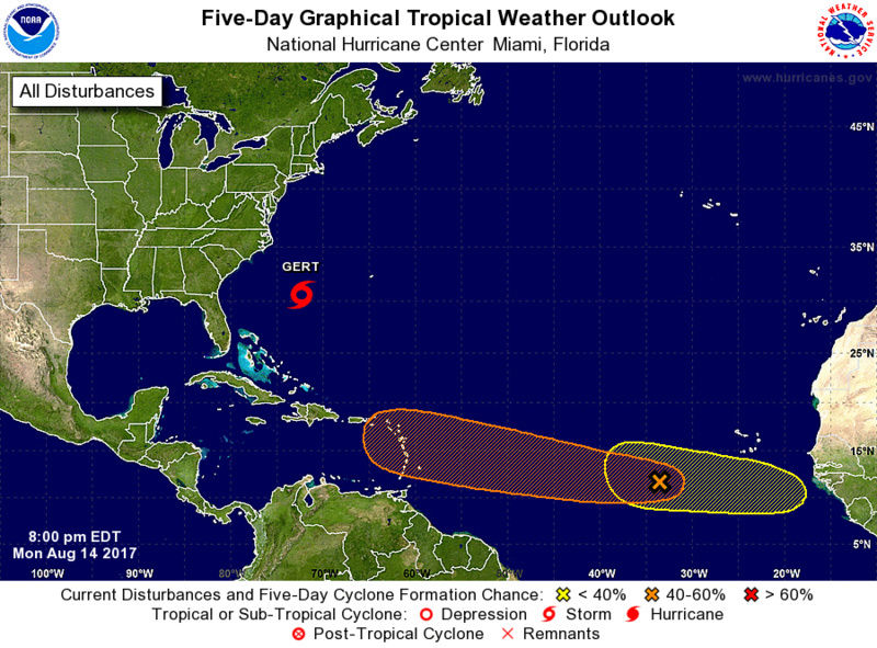
![]() by jmanley32 Sun Aug 13, 2017 7:25 pm
by jmanley32 Sun Aug 13, 2017 7:25 pm
Tropical Weather Outlook
NWS National Hurricane Center Miami FL
800 PM EDT Sun Aug 13 2017
For the North Atlantic...Caribbean Sea and the Gulf of Mexico:
The National Hurricane Center is issuing advisories on recently
upgraded Tropical Storm Gert, located several hundred miles west-
southwest of Bermuda.
1. A large and complex area of disturbed weather to the south and
southwest of the Cabo Verde Islands is associated with a broad
trough of low pressure and a tropical wave. These systems are
forecast to merge over the next day or two, and environmental
conditions are then expected to be conducive for development of
this disturbance later this week while it moves westward at about
15 mph over the tropical Atlantic.
* Formation chance through 48 hours...low...10 percent.
* Formation chance through 5 days...medium...40 percent.
jmanley32- Senior Enthusiast
- Posts : 20513
Reputation : 108
Join date : 2013-12-12
Age : 42
Location : Yonkers, NY
Re: 2017 General Tropical Cyclone Discussion Thread
![]() by jmanley32 Sun Aug 13, 2017 9:31 pm
by jmanley32 Sun Aug 13, 2017 9:31 pm
http://www.ssd.noaa.gov/PS/TROP/floaters/08L/imagery/rb_lalo-animated.gif
jmanley32- Senior Enthusiast
- Posts : 20513
Reputation : 108
Join date : 2013-12-12
Age : 42
Location : Yonkers, NY
Re: 2017 General Tropical Cyclone Discussion Thread
![]() by rb924119 Sun Aug 13, 2017 10:34 pm
by rb924119 Sun Aug 13, 2017 10:34 pm
jmanley32 wrote:WOW, Gert may be going through RI, looks like a eye may be trying to form.
http://www.ssd.noaa.gov/PS/TROP/floaters/08L/imagery/rb_lalo-animated.gif
You fell asleep on it, didn't you, Jman? lmfaoooooo
rb924119- Meteorologist

- Posts : 6890
Reputation : 194
Join date : 2013-02-06
Age : 32
Location : Greentown, Pa
Re: 2017 General Tropical Cyclone Discussion Thread
![]() by jmanley32 Sun Aug 13, 2017 11:46 pm
by jmanley32 Sun Aug 13, 2017 11:46 pm
No but I did not think it would wind up quite so fast.rb924119 wrote:jmanley32 wrote:WOW, Gert may be going through RI, looks like a eye may be trying to form.
http://www.ssd.noaa.gov/PS/TROP/floaters/08L/imagery/rb_lalo-animated.gif
You fell asleep on it, didn't you, Jman? lmfaoooooo
What are your feelings with 91L one to watch? All 3 major models as I said are already on it and take it close or into the US east coast as early as 23rd.
jmanley32- Senior Enthusiast
- Posts : 20513
Reputation : 108
Join date : 2013-12-12
Age : 42
Location : Yonkers, NY
Re: 2017 General Tropical Cyclone Discussion Thread
![]() by rb924119 Mon Aug 14, 2017 6:42 am
by rb924119 Mon Aug 14, 2017 6:42 am
jmanley32 wrote:No but I did not think it would wind up quite so fast.rb924119 wrote:jmanley32 wrote:WOW, Gert may be going through RI, looks like a eye may be trying to form.
http://www.ssd.noaa.gov/PS/TROP/floaters/08L/imagery/rb_lalo-animated.gif
You fell asleep on it, didn't you, Jman? lmfaoooooo
What are your feelings with 91L one to watch? All 3 major models as I said are already on it and take it close or into the US east coast as early as 23rd.
Haha don't worry, you definitely aren't alone with that. I know most of my friends thought I was crazy for insisting it would become a hurricane. Starting with 00z runs LAST NIGHT modeling is finally catching on and showing development, so I've taken a lot of flack so far ahaha as for the other systems, I haven't looked at them yet because I've been so focused on Gert. However, once Gert recurves as (hopefully) a hurricane, I'll switch my focus. The reason for that is because trying to follow and comment on multiple storms gets confusing for the people who follow my FB account and can't follow everything, so I've found that fosusing on one at a time works well, though I do try to at least mention something about any other events if, and only if, the situation presents itself.
I'll also add that a secondary reason that I haven't paid attention beyond Gert is because I've had this forecast on the line for a while so want to see it through until the end; no matter the outcome ahahaha self verification whether for good or ill has yet to be determined, but it always helps one to learn and improve for next time lmaooo
rb924119- Meteorologist
- Posts : 6890
Reputation : 194
Join date : 2013-02-06
Age : 32
Location : Greentown, Pa
Re: 2017 General Tropical Cyclone Discussion Thread
![]() by Radz Mon Aug 14, 2017 7:03 am
by Radz Mon Aug 14, 2017 7:03 am
jmanley32 wrote:No but I did not think it would wind up quite so fast.rb924119 wrote:jmanley32 wrote:WOW, Gert may be going through RI, looks like a eye may be trying to form.
http://www.ssd.noaa.gov/PS/TROP/floaters/08L/imagery/rb_lalo-animated.gif
You fell asleep on it, didn't you, Jman? lmfaoooooo
What are your feelings with 91L one to watch? All 3 major models as I said are already on it and take it close or into the US east coast as early as 23rd.
Many are taking notice of 91L (would be Harvey) - could it become the 1st Major Hurricane of the 2017 Atlantic season? Time will tell
Radz- Pro Enthusiast
- Posts : 1028
Reputation : 17
Join date : 2013-01-12
Location : Cortlandt Manor NY
Re: 2017 General Tropical Cyclone Discussion Thread
![]() by sroc4 Mon Aug 14, 2017 7:25 am
by sroc4 Mon Aug 14, 2017 7:25 am
rb924119 wrote:jmanley32 wrote:No but I did not think it would wind up quite so fast.rb924119 wrote:jmanley32 wrote:WOW, Gert may be going through RI, looks like a eye may be trying to form.
http://www.ssd.noaa.gov/PS/TROP/floaters/08L/imagery/rb_lalo-animated.gif
You fell asleep on it, didn't you, Jman? lmfaoooooo
What are your feelings with 91L one to watch? All 3 major models as I said are already on it and take it close or into the US east coast as early as 23rd.
Haha don't worry, you definitely aren't alone with that. I know most of my friends thought I was crazy for insisting it would become a hurricane. Starting with 00z runs LAST NIGHT modeling is finally catching on and showing development, so I've taken a lot of flack so far ahaha as for the other systems, I haven't looked at them yet because I've been so focused on Gert. However, once Gert recurves as (hopefully) a hurricane, I'll switch my focus. The reason for that is because trying to follow and comment on multiple storms gets confusing for the people who follow my FB account and can't follow everything, so I've found that fosusing on one at a time works well, though I do try to at least mention something about any other events if, and only if, the situation presents itself.
I'll also add that a secondary reason that I haven't paid attention beyond Gert is because I've had this forecast on the line for a while so want to see it through until the end; no matter the outcome ahahaha self verification whether for good or ill has yet to be determined, but it always helps one to learn and improve for next time lmaooo
I don't think you have anything to worry about Ray. Your forecast has been verified even if Gert develops no further. Although I had been stressing don't sleep on 99L as a generality because I had been focused on the 3-5day time frame:
by sroc4 on Sun Aug 06, 2017 11:09 am
As far as 99L is concerned, yes as Mike pointed out above the Euro now has the system developed into a tropical storm just off the SE coast by the end of its run at hr 240. To cont beating a dead horse I will reiterate that the Euro is by far the best global model when it comes to handling the tropics. That said we should still be wary of any model beyond 3-5days, esp when the system isn't formed yet, and even more ESP when the system is an exceptionally broad disorganized area of convection and vorticity as 99L continues to be......
All this said in no way should we sleep on 99L. For now for the next 3-5days it appears that the inhibitory factors are over coming the more favorable conditions, so significant development is unlikely at this time, but This is not a forgone conclusion.....
Don't trust any model right now beyond 5-7 days regarding 99L,(although I certainly raise an eyebrow more so when the euro shows something significant in the long range), but realize it will remain a threat to the US until the wave is caught up in the westerly's and is somewhere over Europe
You really had been the one to confidently say before anyone else that this system was likely to develop. Here was your post :
Post by rb924119 on Mon Aug 07, 2017 4:50 am
Whatever the name of that Invest area in the MDR, it has caught my attention. Not because of what it's (not) going to do this week as it treks across the Atlantic, as discussed by Scott, but because of the potential it has once it gets nearer the Bahamas later this weekend and early next week. I'm mildly entertained by the setup, and think it will have a decent chance to quickly organize/deepen and parallel the East Coast as a named system. Long way to go, though.
One week later from that comment your forecast verifies. Well done!!
_________________
"In weather and in life, there's no winning and losing; there's only winning and learning."
WINTER 2012/2013 TOTALS 43.65"WINTER 2017/2018 TOTALS 62.85" WINTER 2022/2023 TOTALS 4.9"
WINTER 2013/2014 TOTALS 64.85"WINTER 2018/2019 TOTALS 14.25" WINTER 2023/2024 TOTALS 13.1"
WINTER 2014/2015 TOTALS 71.20"WINTER 2019/2020 TOTALS 6.35"
WINTER 2015/2016 TOTALS 35.00"WINTER 2020/2021 TOTALS 37.75"
WINTER 2016/2017 TOTALS 42.25"WINTER 2021/2022 TOTALS 31.65"

sroc4- Admin

- Posts : 8331
Reputation : 301
Join date : 2013-01-07
Location : Wading River, LI
Re: 2017 General Tropical Cyclone Discussion Thread
![]() by rb924119 Mon Aug 14, 2017 8:06 am
by rb924119 Mon Aug 14, 2017 8:06 am
rb924119- Meteorologist
- Posts : 6890
Reputation : 194
Join date : 2013-02-06
Age : 32
Location : Greentown, Pa
Re: 2017 General Tropical Cyclone Discussion Thread
![]() by rb924119 Mon Aug 14, 2017 11:01 am
by rb924119 Mon Aug 14, 2017 11:01 am
rb924119- Meteorologist
- Posts : 6890
Reputation : 194
Join date : 2013-02-06
Age : 32
Location : Greentown, Pa
Re: 2017 General Tropical Cyclone Discussion Thread
![]() by sroc4 Mon Aug 14, 2017 12:08 pm
by sroc4 Mon Aug 14, 2017 12:08 pm
rb924119 wrote:3k NAM puts Gert on a diet and exercise regimen over the next 48 hours to train him/her up to a lean, mean, storm machine......gets it down to 945 hPa off the Carolinas!!
Its a potent jet streak as per the 12z GFS in a favorable position:

_________________
"In weather and in life, there's no winning and losing; there's only winning and learning."
WINTER 2012/2013 TOTALS 43.65"WINTER 2017/2018 TOTALS 62.85" WINTER 2022/2023 TOTALS 4.9"
WINTER 2013/2014 TOTALS 64.85"WINTER 2018/2019 TOTALS 14.25" WINTER 2023/2024 TOTALS 13.1"
WINTER 2014/2015 TOTALS 71.20"WINTER 2019/2020 TOTALS 6.35"
WINTER 2015/2016 TOTALS 35.00"WINTER 2020/2021 TOTALS 37.75"
WINTER 2016/2017 TOTALS 42.25"WINTER 2021/2022 TOTALS 31.65"
sroc4- Admin
- Posts : 8331
Reputation : 301
Join date : 2013-01-07
Location : Wading River, LI
Re: 2017 General Tropical Cyclone Discussion Thread
![]() by jmanley32 Mon Aug 14, 2017 12:11 pm
by jmanley32 Mon Aug 14, 2017 12:11 pm
jeeze u think?rb924119 wrote:3k NAM puts Gert on a diet and exercise regimen over the next 48 hours to train him/her up to a lean, mean, storm machine......gets it down to 945 hPa off the Carolinas!!
jmanley32- Senior Enthusiast
- Posts : 20513
Reputation : 108
Join date : 2013-12-12
Age : 42
Location : Yonkers, NY
Re: 2017 General Tropical Cyclone Discussion Thread
![]() by rb924119 Mon Aug 14, 2017 2:14 pm
by rb924119 Mon Aug 14, 2017 2:14 pm
sroc4 wrote:rb924119 wrote:3k NAM puts Gert on a diet and exercise regimen over the next 48 hours to train him/her up to a lean, mean, storm machine......gets it down to 945 hPa off the Carolinas!!
Its a potent jet streak as per the 12z GFS in a favorable position:
Yeah it is. Though not surprising given this particular run - the deeper the system, the larger the amount of diabatic heating feeding into the western flank of the ridge, thus increasing confluence and amplifying the jet. Do I buy it? Idk. Certainly possible, as we know the nature of these feedback mechanisms and how quickly they can amplify systems. The GFS is also getting it rather strong now, which is a complete 180 from it's last who knows how many runs, and the rest of guidance is holding steady around a Cat-1. I personally feel that a Cat-2 will be the limit for this particular system, but can also see how it gets there, even though I think it remains within the confines of Cat-1 intensity.
rb924119- Meteorologist
- Posts : 6890
Reputation : 194
Join date : 2013-02-06
Age : 32
Location : Greentown, Pa
Re: 2017 General Tropical Cyclone Discussion Thread
![]() by sroc4 Mon Aug 14, 2017 3:16 pm
by sroc4 Mon Aug 14, 2017 3:16 pm

_________________
"In weather and in life, there's no winning and losing; there's only winning and learning."
WINTER 2012/2013 TOTALS 43.65"WINTER 2017/2018 TOTALS 62.85" WINTER 2022/2023 TOTALS 4.9"
WINTER 2013/2014 TOTALS 64.85"WINTER 2018/2019 TOTALS 14.25" WINTER 2023/2024 TOTALS 13.1"
WINTER 2014/2015 TOTALS 71.20"WINTER 2019/2020 TOTALS 6.35"
WINTER 2015/2016 TOTALS 35.00"WINTER 2020/2021 TOTALS 37.75"
WINTER 2016/2017 TOTALS 42.25"WINTER 2021/2022 TOTALS 31.65"
sroc4- Admin
- Posts : 8331
Reputation : 301
Join date : 2013-01-07
Location : Wading River, LI
Re: 2017 General Tropical Cyclone Discussion Thread
![]() by jmanley32 Mon Aug 14, 2017 3:42 pm
by jmanley32 Mon Aug 14, 2017 3:42 pm
jmanley32- Senior Enthusiast
- Posts : 20513
Reputation : 108
Join date : 2013-12-12
Age : 42
Location : Yonkers, NY
Re: 2017 General Tropical Cyclone Discussion Thread
![]() by rb924119 Mon Aug 14, 2017 5:03 pm
by rb924119 Mon Aug 14, 2017 5:03 pm
jmanley32 wrote:GFS now does not like 91L nor does Euro really but Euro is blowing up next wave but goes immediately OTS. We will see, no development, no real knowing what th CMC has been doing better than GFS honestly, which is amazing.e models are latching onto.
Using Gert as an example, Jman, pattern recognition >> modeling. The models will likely continue to struggle with the system(s) until the circulation(s) become(s) better defined. Right now everything is so close together that the models don't know what region of convection to latch onto and how to handle it. Then, they don't know what the North American pattern will be like down the road once this gets closer, so they don't know if they should or shouldn't develop it. The questions we should all be asking is not "What do the models say about the storm(s)?", rather, "What inferences can be made from what we have seen thus far in the modeled North American pattern versus what verifies compared with what the modeling is saying now; what will the water temperatures (anomalies) look like and how will that play a role with everything, and what does the shorter term environment ahead of the system(s) look like?" If we, whether collectively or individually is irrelevant, can answer these questions, we will be able get our answers well ahead of any guidance.
rb924119- Meteorologist
- Posts : 6890
Reputation : 194
Join date : 2013-02-06
Age : 32
Location : Greentown, Pa
Re: 2017 General Tropical Cyclone Discussion Thread
![]() by sroc4 Mon Aug 14, 2017 5:24 pm
by sroc4 Mon Aug 14, 2017 5:24 pm
rb924119 wrote:jmanley32 wrote:GFS now does not like 91L nor does Euro really but Euro is blowing up next wave but goes immediately OTS. We will see, no development, no real knowing what th CMC has been doing better than GFS honestly, which is amazing.e models are latching onto.
Using Gert as an example, Jman, pattern recognition >> modeling. The models will likely continue to struggle with the system(s) until the circulation(s) become(s) better defined. Right now everything is so close together that the models don't know what region of convection to latch onto and how to handle it. Then, they don't know what the North American pattern will be like down the road once this gets closer, so they don't know if they should or shouldn't develop it. The questions we should all be asking is not "What do the models say about the storm(s)?", rather, "What inferences can be made from what we have seen thus far in the modeled North American pattern versus what verifies compared with what the modeling is saying now; what will the water temperatures (anomalies) look like and how will that play a role with everything, and what does the shorter term environment ahead of the system(s) look like?" If we, whether collectively or individually is irrelevant, can answer these questions, we will be able get our answers well ahead of any guidance.
THIS!!! I havent even looked at 91L yet or the NA pattern. With a system like this, just like 99L, you HAVE to take it 3-5 days at a time. Just like 99L, 91L is a broad area of convection and a large open wave. These can take time to consolidate and as was pointed out multiple times with 99L as well as by Ray above models will cont to struggle to find a focal point to initiate on.
_________________
"In weather and in life, there's no winning and losing; there's only winning and learning."
WINTER 2012/2013 TOTALS 43.65"WINTER 2017/2018 TOTALS 62.85" WINTER 2022/2023 TOTALS 4.9"
WINTER 2013/2014 TOTALS 64.85"WINTER 2018/2019 TOTALS 14.25" WINTER 2023/2024 TOTALS 13.1"
WINTER 2014/2015 TOTALS 71.20"WINTER 2019/2020 TOTALS 6.35"
WINTER 2015/2016 TOTALS 35.00"WINTER 2020/2021 TOTALS 37.75"
WINTER 2016/2017 TOTALS 42.25"WINTER 2021/2022 TOTALS 31.65"
sroc4- Admin
- Posts : 8331
Reputation : 301
Join date : 2013-01-07
Location : Wading River, LI
Re: 2017 General Tropical Cyclone Discussion Thread
![]() by jmanley32 Mon Aug 14, 2017 7:07 pm
by jmanley32 Mon Aug 14, 2017 7:07 pm
jmanley32- Senior Enthusiast
- Posts : 20513
Reputation : 108
Join date : 2013-12-12
Age : 42
Location : Yonkers, NY
Re: 2017 General Tropical Cyclone Discussion Thread
![]() by jmanley32 Mon Aug 14, 2017 8:13 pm
by jmanley32 Mon Aug 14, 2017 8:13 pm
jmanley32- Senior Enthusiast
- Posts : 20513
Reputation : 108
Join date : 2013-12-12
Age : 42
Location : Yonkers, NY
Re: 2017 General Tropical Cyclone Discussion Thread
![]() by rb924119 Mon Aug 14, 2017 9:58 pm
by rb924119 Mon Aug 14, 2017 9:58 pm
rb924119- Meteorologist
- Posts : 6890
Reputation : 194
Join date : 2013-02-06
Age : 32
Location : Greentown, Pa
Re: 2017 General Tropical Cyclone Discussion Thread
![]() by Dunnzoo Mon Aug 14, 2017 10:24 pm
by Dunnzoo Mon Aug 14, 2017 10:24 pm
rb924119 wrote:I'm putting this out there now; I only glanced at things on my phone so take this as you will, but man oh man I am absolutely concerned for the East Coast in the 8-11/7-10 day period, especially with the look of the EURO Ensemble 500hPa maps.
Can you post a map when you get a chance, or link? I am going to be down the shore from 8/19-9/2. Any of our shore peeps, how about a gtg? I'll be in Seaside Park
_________________
Janet
Snowfall winter of 2023-2024 17.5"
Snowfall winter of 2022-2023 6.0"
Snowfall winter of 2021-2022 17.6" 1" sleet 2/25/22
Snowfall winter of 2020-2021 51.1"
Snowfall winter of 2019-2020 8.5"
Snowfall winter of 2018-2019 25.1"
Snowfall winter of 2017-2018 51.9"
Snowfall winter of 2016-2017 45.6"
Snowfall winter of 2015-2016 29.5"
Snowfall winter of 2014-2015 50.55"
Snowfall winter of 2013-2014 66.5"

Dunnzoo- Senior Enthusiast - Mod
- Posts : 4891
Reputation : 68
Join date : 2013-01-11
Age : 62
Location : Westwood, NJ
Re: 2017 General Tropical Cyclone Discussion Thread
![]() by jmanley32 Mon Aug 14, 2017 10:25 pm
by jmanley32 Mon Aug 14, 2017 10:25 pm
Hoilding you to it for some excitement, hey you were spot on with your predictions of Gert. I heard Gert has slowed even more, Theres no way that if she slows so much could miss the front? Can you elaborate about the 10 day and which system your concerned (assuming 91L?) though all sgetti plots right now show a gulf run, but of course we dont know where formation will take place so that could change drastically. Interestingly enough, its not the ellusive "I" storm yet but this is close in date to when Irene struck (end of August). Entire EC? Interested to hear your thoughts, maybe a video in a few days if 500mb still looks like you say?rb924119 wrote:I'm putting this out there now; I only glanced at things on my phone so take this as you will, but man oh man I am absolutely concerned for the East Coast in the 8-11/7-10 day period, especially with the look of the EURO Ensemble 500hPa maps.
jmanley32- Senior Enthusiast
- Posts : 20513
Reputation : 108
Join date : 2013-12-12
Age : 42
Location : Yonkers, NY
Page 8 of 40 • 1 ... 5 ... 7, 8, 9 ... 24 ... 40 ![]()
|
|
|