
 Search
Tracking Hurricane Irma
Page 6 of 35 •  1 ... 5, 6, 7 ... 20 ... 35
 ![]()
Re: Tracking Hurricane Irma
![]() by jmanley32 Sat Sep 02, 2017 9:24 am
by jmanley32 Sat Sep 02, 2017 9:24 am
https://mobile.twitter.com/MJVentrice/status/903944867822362624/photo/1
Last edited by jmanley32 on Sat Sep 02, 2017 9:49 am; edited 1 time in total
jmanley32- Senior Enthusiast

- Posts : 20535
Join date : 2013-12-12
Re: Tracking Hurricane Irma
![]() by jmanley32 Sat Sep 02, 2017 9:25 am
by jmanley32 Sat Sep 02, 2017 9:25 am
no cmc was a miss but very close. But my PT was it's the southernmost.RJB8525 wrote:so Euro is the only one not showing a tri-state complete hit?
jmanley32- Senior Enthusiast
- Posts : 20535
Join date : 2013-12-12
Re: Tracking Hurricane Irma
![]() by nutleyblizzard Sat Sep 02, 2017 9:52 am
by nutleyblizzard Sat Sep 02, 2017 9:52 am
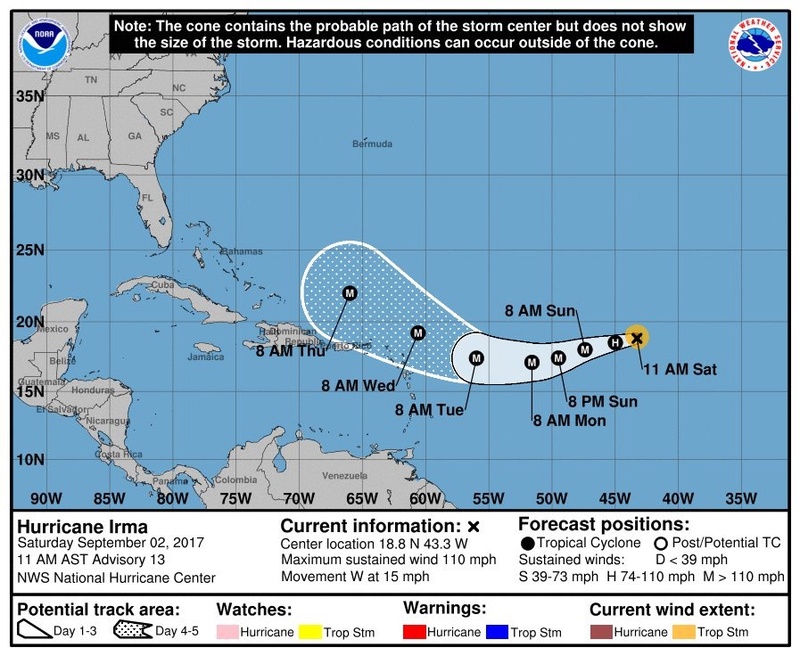
As of right now, I would say 60-40 that this makes US landfall. The WAR has been prevalent in these model runs. Even if Irma misses the trough which is becoming more unlikely, the ridge will most likely deflect the hurricane albeit further south. Anywhere from Georgia to Maine could have significant impacts with this dangerous storm. I think that the Gulf states are out of the game on this one, with Florida becoming much less unlikely. My gut tells me landfall occurs in OBX then comes up the coastline.jmanley32 wrote:Wow 50% chance already of major covers entire east coast. I don't care what some might think I do not think this one is going it's. And no that's not wishcasting.
https://mobile.twitter.com/MJVentrice/status/903944867822362624/photo/1

nutleyblizzard- Senior Enthusiast
- Posts : 1954
Reputation : 41
Join date : 2014-01-30
Age : 58
Location : Nutley, new jersey
Re: Tracking Hurricane Irma
![]() by sroc4 Sat Sep 02, 2017 10:10 am
by sroc4 Sat Sep 02, 2017 10:10 am
As of this morning Irma's movement is no longer WNW, but rather she now has a trajectory of due west to even slightly WSW.

As we proceed throughout today into tomorrow I expect to see the track start moving SSW to SW. What I think has become pretty clear, at least in my minds eye, is the track over the next 4-5 days. I personally agree with the NHC track:

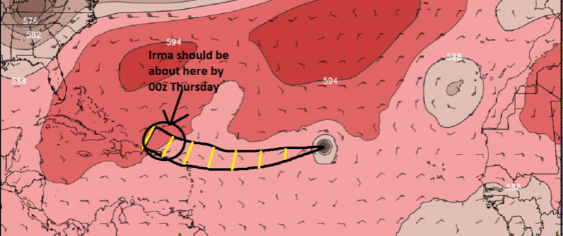
So by about 00z Thursday Irma should be somewhere just north of Hispaniola area. Now lets loo at the H5 set up on 00z Thursday. see below:


There are some subtle differences, but the overall H5 set up is about the same on both Euro and GFS heading into 00z Thursday. The Western Atlantic Ridge(WAR) has a nose into Florida, a deep long wave trough over the Midwest approaching the EC, and a strong PNA ridge in the western CONUS. This is where the two models diverge however.
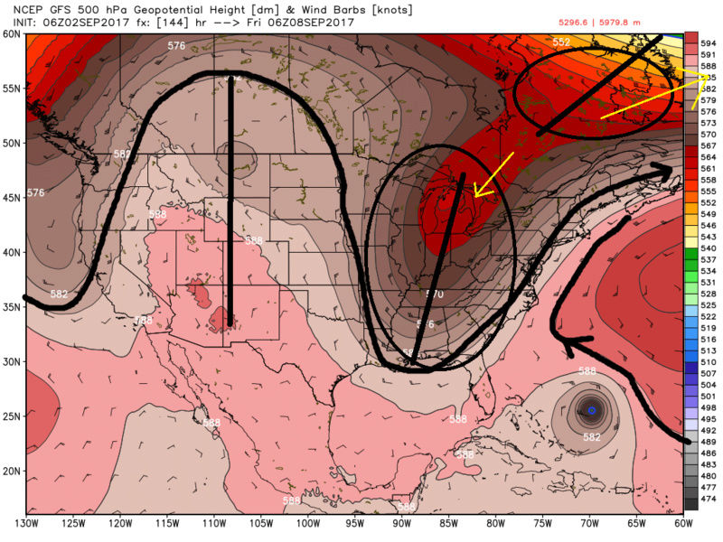
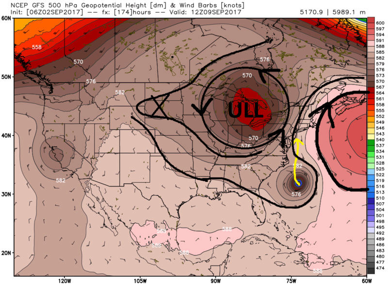
By about 6z Friday(first image below) the GFS has been fairly consistent with showing a full on trough split. Notice in the first image I have two aeas circled. The northern most is a piece of the trough that lifts up and out; whereas, the second piece of the trough is beginning to cutoff from the main westerly flow. By 12Z Sat(second image below) it is cutoff from the main flow as indicated by an upper level low (ULL) allowing the WAR to build into SE Canada effectively blocking Irma from escaping OTS and steering her into the coast. As can be clearly seen on the second image below the ULL and WAR provide the alley way right up the coast. So this is why the GFS has been showing a landfall north of OBX.
The European on the other hand by 6z Friday(first image below) instead of slitting the main long wave trough it trys to kick the whole thing out. The result is by 12z Sat Irma misses the trough and weak ridging builds over top steering it further south and west when compared to the GFS. Its the next piece of energy (black X in the second image) indicated by yellow arrow that eventually draws Irma N into the Carolinas.
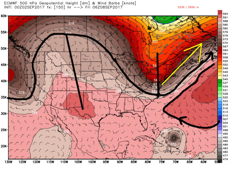
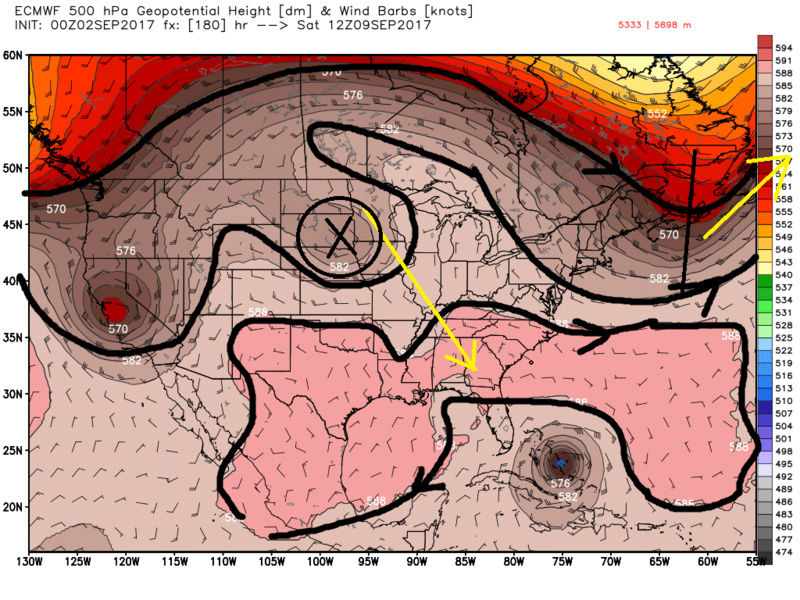
Here is the side by side comparison of the H5 set up between the GFS and Euro by 06z Friday. As you can see models beyond day 4-5 are still worlds apart with the H5 setup, regarding what happens to the trough as wel as ridging out west, and even what's happening in the E Pac, but I won't get into those details. So again we cant take any soln seriously yet. For me personally I will say I am heavily leaning against a landfall or track that ends up south of Cape Canaveral Fla and or into the GOM. This does not mean; however, that I am excluding a landfall south of that nor am I excluding a track that takes Irma into the E GOM either. In addition I am still not excluding the mean trough picking Irma up and re-curving her OTS before an EC landfall. I think both of those solns are becoming less likely, meaning I am favoring an EC landfall some where between Cape Canaveral Fl and Cape Cod Mass. Gun to head (60%-40%) leaning towards a landfall between Cape Canaveral Fla and OBX vs OBX to Cape Cod Ma respectively. A few more days and we should start to see the two global models converge on the H5 setup.

_________________
"In weather and in life, there's no winning and losing; there's only winning and learning."
WINTER 2012/2013 TOTALS 43.65"WINTER 2017/2018 TOTALS 62.85" WINTER 2022/2023 TOTALS 4.9"
WINTER 2013/2014 TOTALS 64.85"WINTER 2018/2019 TOTALS 14.25" WINTER 2023/2024 TOTALS 13.1"
WINTER 2014/2015 TOTALS 71.20"WINTER 2019/2020 TOTALS 6.35"
WINTER 2015/2016 TOTALS 35.00"WINTER 2020/2021 TOTALS 37.75"
WINTER 2016/2017 TOTALS 42.25"WINTER 2021/2022 TOTALS 31.65"

sroc4- Admin

- Posts : 8354
Reputation : 302
Join date : 2013-01-07
Location : Wading River, LI
Re: Tracking Hurricane Irma
![]() by sroc4 Sat Sep 02, 2017 10:14 am
by sroc4 Sat Sep 02, 2017 10:14 am
jmanley32 wrote:Wow 50% chance already of major covers entire east coast. I don't care what some might think I do not think this one is going ots. And no that's not wishcasting.
https://mobile.twitter.com/MJVentrice/status/903944867822362624/photo/1
Ha looks like Donald Trump and MV are buds. Looks like Trump was thanking him..lol
_________________
"In weather and in life, there's no winning and losing; there's only winning and learning."
WINTER 2012/2013 TOTALS 43.65"WINTER 2017/2018 TOTALS 62.85" WINTER 2022/2023 TOTALS 4.9"
WINTER 2013/2014 TOTALS 64.85"WINTER 2018/2019 TOTALS 14.25" WINTER 2023/2024 TOTALS 13.1"
WINTER 2014/2015 TOTALS 71.20"WINTER 2019/2020 TOTALS 6.35"
WINTER 2015/2016 TOTALS 35.00"WINTER 2020/2021 TOTALS 37.75"
WINTER 2016/2017 TOTALS 42.25"WINTER 2021/2022 TOTALS 31.65"
sroc4- Admin
- Posts : 8354
Reputation : 302
Join date : 2013-01-07
Location : Wading River, LI

weatherwatchermom- Senior Enthusiast
- Posts : 3793
Reputation : 78
Join date : 2014-11-25
Location : Hazlet Township, NJ
Re: Tracking Hurricane Irma
![]() by sroc4 Sat Sep 02, 2017 10:21 am
by sroc4 Sat Sep 02, 2017 10:21 am
1) we have a well defined system for both models to initiate on; not a disorganized area of convection which is what I think the GFS struggles mightily with. and
2) This is more about which model is handling the H5 set up over the Atlantic, north America, and the Pac better rather than which one is handling the actual tropical system better. This closes the gap between the euro and the GFS IMO regarding which one is better. Euro still handles complex set ups better than the GFS in general, but as others have mentioned already GFS was a little bit faster with Harvey, and go back to Juno, (I know Im cringing myself), The GFS was ahead of the Euro reading the H5 setup and Juno ended up further east than expected.
_________________
"In weather and in life, there's no winning and losing; there's only winning and learning."
WINTER 2012/2013 TOTALS 43.65"WINTER 2017/2018 TOTALS 62.85" WINTER 2022/2023 TOTALS 4.9"
WINTER 2013/2014 TOTALS 64.85"WINTER 2018/2019 TOTALS 14.25" WINTER 2023/2024 TOTALS 13.1"
WINTER 2014/2015 TOTALS 71.20"WINTER 2019/2020 TOTALS 6.35"
WINTER 2015/2016 TOTALS 35.00"WINTER 2020/2021 TOTALS 37.75"
WINTER 2016/2017 TOTALS 42.25"WINTER 2021/2022 TOTALS 31.65"
sroc4- Admin
- Posts : 8354
Reputation : 302
Join date : 2013-01-07
Location : Wading River, LI
Re: Tracking Hurricane Irma
![]() by sroc4 Sat Sep 02, 2017 10:22 am
by sroc4 Sat Sep 02, 2017 10:22 am
weatherwatchermom wrote:thank you Sroc and Nutley
You bet! And thank you for the birthday wishes while I was away...we had a blast! I know.....banter
_________________
"In weather and in life, there's no winning and losing; there's only winning and learning."
WINTER 2012/2013 TOTALS 43.65"WINTER 2017/2018 TOTALS 62.85" WINTER 2022/2023 TOTALS 4.9"
WINTER 2013/2014 TOTALS 64.85"WINTER 2018/2019 TOTALS 14.25" WINTER 2023/2024 TOTALS 13.1"
WINTER 2014/2015 TOTALS 71.20"WINTER 2019/2020 TOTALS 6.35"
WINTER 2015/2016 TOTALS 35.00"WINTER 2020/2021 TOTALS 37.75"
WINTER 2016/2017 TOTALS 42.25"WINTER 2021/2022 TOTALS 31.65"
sroc4- Admin
- Posts : 8354
Reputation : 302
Join date : 2013-01-07
Location : Wading River, LI
Re: Tracking Hurricane Irma
![]() by SoulSingMG Sat Sep 02, 2017 10:25 am
by SoulSingMG Sat Sep 02, 2017 10:25 am
sroc4 wrote:Just a side note. In general we have been saying all summer how bad the GFS is handling tropics and the Euro is far superior. And in general this is true, but keep these things in mind.
1) we have a well defined system for both models to initiate on; not a disorganized area of convection which is what I think the GFS struggles mightily with. and
2) This is more about which model is handling the H5 set up over the Atlantic, north America, and the Pac better rather than which one is handling the actual tropical system better. This closes the gap between the euro and the GFS IMO regarding which one is better. Euro still handles complex set ups better than the GFS in general, but as others have mentioned already GFS was a little bit faster with Harvey, and go back to Juno, (I know Im cringing myself), The GFS was ahead of the Euro reading the H5 setup and Juno ended up further east than expected.
THIS. Definitely something to keep in the back of ur noggin for now. Man it's gonna be a long week.


SoulSingMG- Senior Enthusiast
- Posts : 2853
Reputation : 74
Join date : 2013-12-11
Location : Long Island City, NY


Snow88- Senior Enthusiast
- Posts : 2193
Reputation : 4
Join date : 2013-01-09
Age : 35
Location : Brooklyn, NY
sabamfa- Pro Enthusiast

- Posts : 246
Reputation : 2
Join date : 2013-11-05
Age : 38
Location : Wayne, NJ
Re: Tracking Hurricane Irma
![]() by SoulSingMG Sat Sep 02, 2017 10:47 am
by SoulSingMG Sat Sep 02, 2017 10:47 am
Snow88 wrote:
Just saw this on Twitter as well....

SoulSingMG- Senior Enthusiast
- Posts : 2853
Reputation : 74
Join date : 2013-12-11
Location : Long Island City, NY
SoulSingMG- Senior Enthusiast
- Posts : 2853
Reputation : 74
Join date : 2013-12-11
Location : Long Island City, NY
Re: Tracking Hurricane Irma
![]() by skinsfan1177 Sat Sep 02, 2017 11:10 am
by skinsfan1177 Sat Sep 02, 2017 11:10 am

skinsfan1177- Senior Enthusiast
- Posts : 4485
Reputation : 35
Join date : 2013-01-07
Age : 46
Location : Point Pleasant Boro
Re: Tracking Hurricane Irma
![]() by jmanley32 Sat Sep 02, 2017 11:22 am
by jmanley32 Sat Sep 02, 2017 11:22 am
I'm honestly quite frightened by the idea of a major hitting up here last 3 gfs runs put the area in the worst and that one over NYC the eye is literally over my street I zoomed in. Crazy week coming. Go b nsil biting imo. I've never seen winds over cat 1 I'm nervous to see 2 and 3 or above good lord. But we keep tracking and if this looks possible by wed or Thurs I'd start preparing if not B4 if we see a h5 consistency develop.skinsfan1177 wrote:Navgem, CMC and GFS all support an H5 capture and slingshot back west.

jmanley32- Senior Enthusiast
- Posts : 20535
Reputation : 108
Join date : 2013-12-12
Age : 43
Location : Yonkers, NY
Re: Tracking Hurricane Irma
![]() by jmanley32 Sat Sep 02, 2017 11:24 am
by jmanley32 Sat Sep 02, 2017 11:24 am
jmanley32- Senior Enthusiast
- Posts : 20535
Reputation : 108
Join date : 2013-12-12
Age : 43
Location : Yonkers, NY
Re: Tracking Hurricane Irma
![]() by jmanley32 Sat Sep 02, 2017 11:45 am
by jmanley32 Sat Sep 02, 2017 11:45 am
No go to the guys page, trump supporter and amateur meterologist, I can see him get in hot water with that page.sroc4 wrote:jmanley32 wrote:Wow 50% chance already of major covers entire east coast. I don't care what some might think I do not think this one is going ots. And no that's not wishcasting.
https://mobile.twitter.com/MJVentrice/status/903944867822362624/photo/1
Ha looks like Donald Trump and MV are buds. Looks like Trump was thanking him..lol
jmanley32- Senior Enthusiast
- Posts : 20535
Reputation : 108
Join date : 2013-12-12
Age : 43
Location : Yonkers, NY
Re: Tracking Hurricane Irma
![]() by jmanley32 Sat Sep 02, 2017 12:00 pm
by jmanley32 Sat Sep 02, 2017 12:00 pm
jmanley32- Senior Enthusiast
- Posts : 20535
Reputation : 108
Join date : 2013-12-12
Age : 43
Location : Yonkers, NY
rb924119- Meteorologist

- Posts : 6928
Reputation : 194
Join date : 2013-02-06
Age : 32
Location : Greentown, Pa
Re: Tracking Hurricane Irma
![]() by Sanchize06 Sat Sep 02, 2017 12:10 pm
by Sanchize06 Sat Sep 02, 2017 12:10 pm
Sanchize06- Senior Enthusiast
- Posts : 1041
Reputation : 21
Join date : 2013-02-05
Location : Union Beach, NJ
Re: Tracking Hurricane Irma
![]() by jmanley32 Sat Sep 02, 2017 12:13 pm
by jmanley32 Sat Sep 02, 2017 12:13 pm
jmanley32- Senior Enthusiast
- Posts : 20535
Reputation : 108
Join date : 2013-12-12
Age : 43
Location : Yonkers, NY
Re: Tracking Hurricane Irma
![]() by jmanley32 Sat Sep 02, 2017 12:16 pm
by jmanley32 Sat Sep 02, 2017 12:16 pm
jmanley32- Senior Enthusiast
- Posts : 20535
Reputation : 108
Join date : 2013-12-12
Age : 43
Location : Yonkers, NY
Re: Tracking Hurricane Irma
![]() by nutleyblizzard Sat Sep 02, 2017 12:19 pm
by nutleyblizzard Sat Sep 02, 2017 12:19 pm
nutleyblizzard- Senior Enthusiast
- Posts : 1954
Reputation : 41
Join date : 2014-01-30
Age : 58
Location : Nutley, new jersey
Re: Tracking Hurricane Irma
![]() by Sanchize06 Sat Sep 02, 2017 12:19 pm
by Sanchize06 Sat Sep 02, 2017 12:19 pm
Sanchize06- Senior Enthusiast
- Posts : 1041
Reputation : 21
Join date : 2013-02-05
Location : Union Beach, NJ
Re: Tracking Hurricane Irma
![]() by jmanley32 Sat Sep 02, 2017 12:20 pm
by jmanley32 Sat Sep 02, 2017 12:20 pm
jmanley32- Senior Enthusiast
- Posts : 20535
Reputation : 108
Join date : 2013-12-12
Age : 43
Location : Yonkers, NY
Re: Tracking Hurricane Irma
![]() by frank 638 Sat Sep 02, 2017 12:20 pm
by frank 638 Sat Sep 02, 2017 12:20 pm
frank 638- Senior Enthusiast
- Posts : 2843
Reputation : 37
Join date : 2016-01-01
Age : 40
Location : bronx ny
weatherwatchermom- Senior Enthusiast
- Posts : 3793
Reputation : 78
Join date : 2014-11-25
Location : Hazlet Township, NJ
Page 6 of 35 • 1 ... 5, 6, 7 ... 20 ... 35 ![]()
|
|
|