
 Search
Tracking Hurricane Irma: Part 2
Page 5 of 21 •  1, 2, 3, 4, 5, 6 ... 13 ... 21
 ![]()
Re: Tracking Hurricane Irma: Part 2
![]() by Guest Wed Sep 06, 2017 6:14 pm
by Guest Wed Sep 06, 2017 6:14 pm
algae888 wrote:As currently modeled at 500 MB there's no way Irma can directly affect our area. If you extrapolated the nam it looks to interact with the departing trough and will probably steer it out to sea. The ridge building into the Northeast and Great Lakes is just too strong for her to penetrate the only way I see her getting up here is if she slows down the ridge slides East and she connects with the trough dropping out of central Canada. That's still a possibility time will tellsyosnow94 wrote:Guys watch the satellite loop. It is obvious that Irma is no longer moving west but now WNW. Almost NW. The turn has started early maybe which would put areas further north in jeopardy no??
I agree it won't affect us directly the way it looks right now. I'm hoping for a ton of rain from her and that she pulls Jose in.
Guest- Guest
Re: Tracking Hurricane Irma: Part 2
![]() by jmanley32 Wed Sep 06, 2017 6:16 pm
by jmanley32 Wed Sep 06, 2017 6:16 pm
Still could change, look at the changes in the upper levels that have changed already, and its very possible Irma slows down, and syo the WNW was always portrayed, look at NHC cone, its WNW until FL.Snow88 wrote:It sucks that there is a big high pressure in the northeast because Irma would have came right up the coast.
jmanley32- Senior Enthusiast

- Posts : 20513
Join date : 2013-12-12
Re: Tracking Hurricane Irma: Part 2
![]() by weatherwatchermom Wed Sep 06, 2017 6:16 pm
by weatherwatchermom Wed Sep 06, 2017 6:16 pm
I knew what you meant..I had just heard about Barbuda..and responded....this is so sad and scary for those in the line of fire..hope all works out for you daughter!!TheAresian wrote:I worded that poorly. I meant that she's moving through the islands without weakening herself by making making landfall, thus doing massive damage while still maintaining her current strength.

weatherwatchermom- Senior Enthusiast
- Posts : 3734
Reputation : 77
Join date : 2014-11-25
Age : 60
Location : Hazlet Township, NJ
Re: Tracking Hurricane Irma: Part 2
![]() by Frank_Wx Wed Sep 06, 2017 6:23 pm
by Frank_Wx Wed Sep 06, 2017 6:23 pm

_________________
_______________________________________________________________________________________________________
CLICK HERE to view NJ Strong Snowstorm Classifications

Frank_Wx- Godzilla Seeker

- Posts : 21305
Reputation : 328
Join date : 2013-01-05
Age : 31
Location : Jersey City, NJ -

Re: Tracking Hurricane Irma: Part 2
![]() by Frank_Wx Wed Sep 06, 2017 6:24 pm
by Frank_Wx Wed Sep 06, 2017 6:24 pm

_________________
_______________________________________________________________________________________________________
CLICK HERE to view NJ Strong Snowstorm Classifications
Frank_Wx- Godzilla Seeker
- Posts : 21305
Reputation : 328
Join date : 2013-01-05
Age : 31
Location : Jersey City, NJ -
Re: Tracking Hurricane Irma: Part 2
![]() by Snow88 Wed Sep 06, 2017 6:30 pm
by Snow88 Wed Sep 06, 2017 6:30 pm
http://www.mahobeachcam.com/

Snow88- Senior Enthusiast
- Posts : 2193
Reputation : 4
Join date : 2013-01-09
Age : 35
Location : Brooklyn, NY
Re: Tracking Hurricane Irma: Part 2
![]() by Guest Wed Sep 06, 2017 6:32 pm
by Guest Wed Sep 06, 2017 6:32 pm
weatherwatchermom wrote:I knew what you meant..I had just heard about Barbuda..and responded....this is so sad and scary for those in the line of fire..hope all works out for you daughter!!TheAresian wrote:I worded that poorly. I meant that she's moving through the islands without weakening herself by making making landfall, thus doing massive damage while still maintaining her current strength.
Thanks. She's watching it closely. Barring a miracle shift east, she's evacuating in 48 hours. This isn't the storm to take chances with.
Guest- Guest
Re: Tracking Hurricane Irma: Part 2
![]() by jmanley32 Wed Sep 06, 2017 6:32 pm
by jmanley32 Wed Sep 06, 2017 6:32 pm
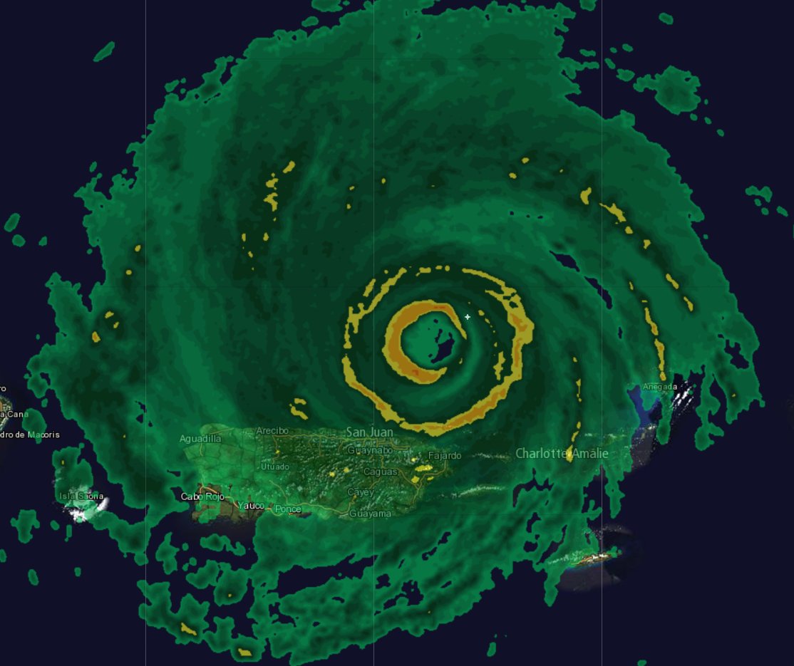
At least it did not make direct landfall, what do you think winds are in san juan 125? Thats a total guess.Frank_Wx wrote:San Juan, PR getting rocked

jmanley32- Senior Enthusiast
- Posts : 20513
Reputation : 108
Join date : 2013-12-12
Age : 42
Location : Yonkers, NY
Re: Tracking Hurricane Irma: Part 2
![]() by algae888 Wed Sep 06, 2017 6:38 pm
by algae888 Wed Sep 06, 2017 6:38 pm

algae888- Advanced Forecaster

- Posts : 5311
Reputation : 46
Join date : 2013-02-05
Age : 61
Location : mt. vernon, new york
Re: Tracking Hurricane Irma: Part 2
![]() by Frank_Wx Wed Sep 06, 2017 6:43 pm
by Frank_Wx Wed Sep 06, 2017 6:43 pm
_________________
_______________________________________________________________________________________________________
CLICK HERE to view NJ Strong Snowstorm Classifications
Frank_Wx- Godzilla Seeker
- Posts : 21305
Reputation : 328
Join date : 2013-01-05
Age : 31
Location : Jersey City, NJ -
Re: Tracking Hurricane Irma: Part 2
![]() by Frank_Wx Wed Sep 06, 2017 6:45 pm
by Frank_Wx Wed Sep 06, 2017 6:45 pm
_________________
_______________________________________________________________________________________________________
CLICK HERE to view NJ Strong Snowstorm Classifications
Frank_Wx- Godzilla Seeker
- Posts : 21305
Reputation : 328
Join date : 2013-01-05
Age : 31
Location : Jersey City, NJ -
Re: Tracking Hurricane Irma: Part 2
![]() by aiannone Wed Sep 06, 2017 6:53 pm
by aiannone Wed Sep 06, 2017 6:53 pm
_________________
-Alex Iannone-

aiannone- Senior Enthusiast - Mod

- Posts : 4813
Reputation : 92
Join date : 2013-01-07
Location : Saint James, LI (Northwest Suffolk Co.)
Re: Tracking Hurricane Irma: Part 2
![]() by amugs Wed Sep 06, 2017 7:07 pm
by amugs Wed Sep 06, 2017 7:07 pm
You can tell by an outer (yellow) band from teh eye wall is forming
ERC = Eyewall Replacement Cycle
_________________
Mugs
AKA:King: Snow Weenie
Self Proclaimed
WINTER 2014-15 : 55.12" +.02 for 6 coatings (avg. 35")
WINTER 2015-16 Total - 29.8" (Avg 35")
WINTER 2016-17 : 39.5" so far

amugs- Advanced Forecaster - Mod
- Posts : 15093
Reputation : 213
Join date : 2013-01-07
Age : 54
Location : Hillsdale,NJ
Re: Tracking Hurricane Irma: Part 2
![]() by jmanley32 Wed Sep 06, 2017 7:12 pm
by jmanley32 Wed Sep 06, 2017 7:12 pm
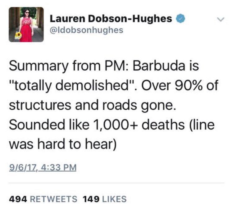
Who is this person? Reliable source, what does she mean the "line"? If thats true utterly terrible.Frank_Wx wrote:
jmanley32- Senior Enthusiast
- Posts : 20513
Reputation : 108
Join date : 2013-12-12
Age : 42
Location : Yonkers, NY
Re: Tracking Hurricane Irma: Part 2
![]() by jmanley32 Wed Sep 06, 2017 7:14 pm
by jmanley32 Wed Sep 06, 2017 7:14 pm
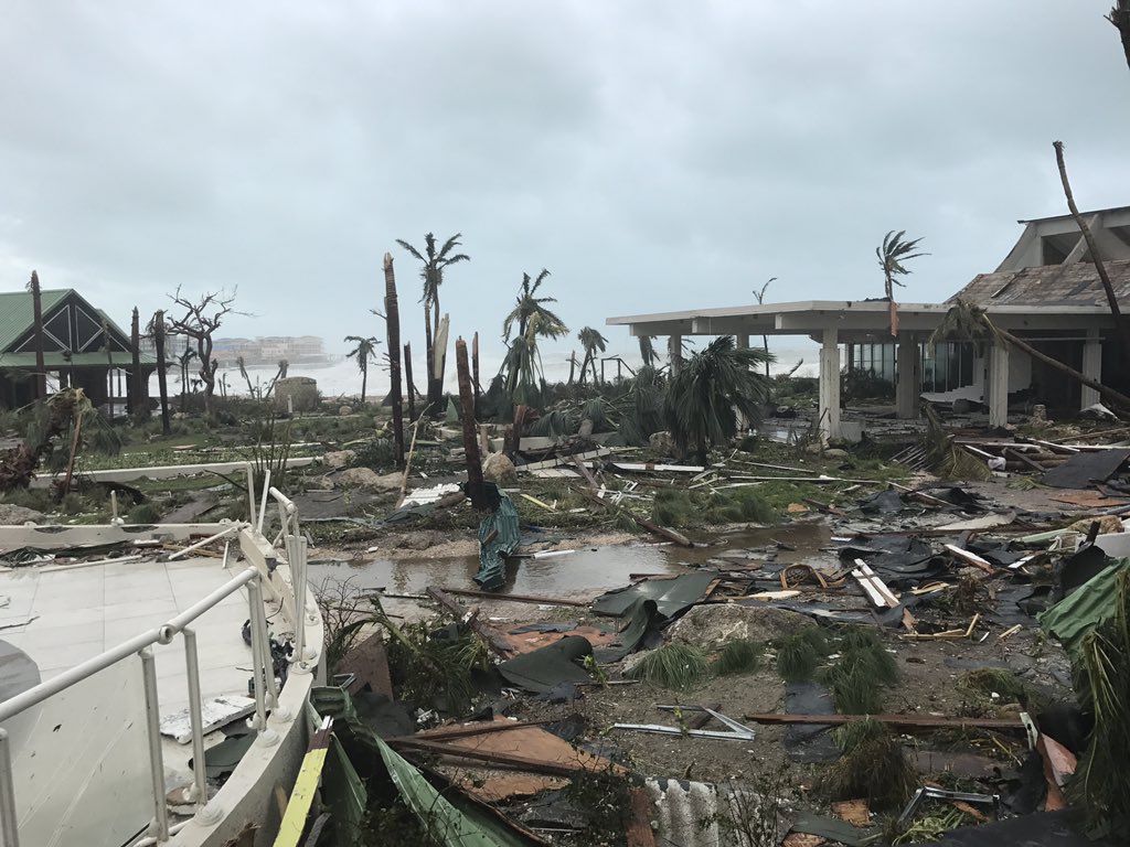
Thank goodness, yes your right, those winds are in the eyewall duh, but yeah mudsleds will be bad but i do not think it will be nearly as bad as barbuda or st. maarten. I see now why no one would ever want to experience this. Those pics are hard to look at.algae888 wrote:Jman San Juan is in the 50s and the Northeast part of the island had a gust to 72 miles per hour. That's per The Weather Channel a couple of hours ago. Don't forget those strong winds are just in a very small area. Rains and mudslides are probably going to cause the most damage there
jmanley32- Senior Enthusiast
- Posts : 20513
Reputation : 108
Join date : 2013-12-12
Age : 42
Location : Yonkers, NY
Re: Tracking Hurricane Irma: Part 2
![]() by jmanley32 Wed Sep 06, 2017 7:16 pm
by jmanley32 Wed Sep 06, 2017 7:16 pm
Well GFS has been steadfast on going sub 900mb, wouldnt take a lot for that to happen, wonder if we get 200mph winds. I heard this is strongest hurricane wasn't matthew 205mph at one pt? Or is it just in this particular region.amugs wrote:ERC happening and once this does bang zoom she will intensify, if that can be imagined!!
You can tell by an outer (yellow) band from teh eye wall is forming
ERC = Eyewall Replacement Cycle
jmanley32- Senior Enthusiast
- Posts : 20513
Reputation : 108
Join date : 2013-12-12
Age : 42
Location : Yonkers, NY
Re: Tracking Hurricane Irma: Part 2
![]() by sroc4 Wed Sep 06, 2017 7:21 pm
by sroc4 Wed Sep 06, 2017 7:21 pm
sroc4 wrote:Frank_Wx wrote:
That Radar loop is indicative of concentric rings Frank, aka double eye wall. Likely the start of another EWRC.

.gif.0f9de32a0a87cfc535462daae196ef17.gif)
_________________
"In weather and in life, there's no winning and losing; there's only winning and learning."
WINTER 2012/2013 TOTALS 43.65"WINTER 2017/2018 TOTALS 62.85" WINTER 2022/2023 TOTALS 4.9"
WINTER 2013/2014 TOTALS 64.85"WINTER 2018/2019 TOTALS 14.25" WINTER 2023/2024 TOTALS 13.1"
WINTER 2014/2015 TOTALS 71.20"WINTER 2019/2020 TOTALS 6.35"
WINTER 2015/2016 TOTALS 35.00"WINTER 2020/2021 TOTALS 37.75"
WINTER 2016/2017 TOTALS 42.25"WINTER 2021/2022 TOTALS 31.65"

sroc4- Admin
- Posts : 8331
Reputation : 301
Join date : 2013-01-07
Location : Wading River, LI
Re: Tracking Hurricane Irma: Part 2
![]() by sroc4 Wed Sep 06, 2017 7:24 pm
by sroc4 Wed Sep 06, 2017 7:24 pm

_________________
"In weather and in life, there's no winning and losing; there's only winning and learning."
WINTER 2012/2013 TOTALS 43.65"WINTER 2017/2018 TOTALS 62.85" WINTER 2022/2023 TOTALS 4.9"
WINTER 2013/2014 TOTALS 64.85"WINTER 2018/2019 TOTALS 14.25" WINTER 2023/2024 TOTALS 13.1"
WINTER 2014/2015 TOTALS 71.20"WINTER 2019/2020 TOTALS 6.35"
WINTER 2015/2016 TOTALS 35.00"WINTER 2020/2021 TOTALS 37.75"
WINTER 2016/2017 TOTALS 42.25"WINTER 2021/2022 TOTALS 31.65"
sroc4- Admin
- Posts : 8331
Reputation : 301
Join date : 2013-01-07
Location : Wading River, LI
Re: Tracking Hurricane Irma: Part 2
![]() by Guest Wed Sep 06, 2017 7:36 pm
by Guest Wed Sep 06, 2017 7:36 pm
Guest- Guest
Re: Tracking Hurricane Irma: Part 2
![]() by jwalsh Wed Sep 06, 2017 7:46 pm
by jwalsh Wed Sep 06, 2017 7:46 pm
The first two sentences I believe are correct. The PM of Antigua and Barbuda was making a speech about the damage to the latter island, never mentioned anything about 1000+ deaths. She was referring to a line of the speech which I'm assuming she wildly misheard, since only one fatality has been reported in Barbuda. Nevertheless, the PM still said that the island is "practically uninhabitable "jmanley32 wrote:Who is this person? Reliable source, what does she mean the "line"? If thats true utterly terrible.Frank_Wx wrote:
jwalsh- Posts : 60
Reputation : 0
Join date : 2016-01-18
Location : Commack, NY
Re: Tracking Hurricane Irma: Part 2
![]() by weatherwatchermom Wed Sep 06, 2017 7:55 pm
by weatherwatchermom Wed Sep 06, 2017 7:55 pm
weatherwatchermom- Senior Enthusiast
- Posts : 3734
Reputation : 77
Join date : 2014-11-25
Age : 60
Location : Hazlet Township, NJ
jmanley32- Senior Enthusiast
- Posts : 20513
Reputation : 108
Join date : 2013-12-12
Age : 42
Location : Yonkers, NY
jmanley32- Senior Enthusiast
- Posts : 20513
Reputation : 108
Join date : 2013-12-12
Age : 42
Location : Yonkers, NY
Re: Tracking Hurricane Irma: Part 2
![]() by amugs Wed Sep 06, 2017 8:21 pm
by amugs Wed Sep 06, 2017 8:21 pm
Extrap. Sfc. Press: 909.1 mb (26.85 inHg)
What I tell ya she was strengthening f it let's get sub 900 we are getting that big time in here path over 85* plus bath water that a deep with latent heat and no shear.
_________________
Mugs
AKA:King: Snow Weenie
Self Proclaimed
WINTER 2014-15 : 55.12" +.02 for 6 coatings (avg. 35")
WINTER 2015-16 Total - 29.8" (Avg 35")
WINTER 2016-17 : 39.5" so far
amugs- Advanced Forecaster - Mod
- Posts : 15093
Reputation : 213
Join date : 2013-01-07
Age : 54
Location : Hillsdale,NJ
Re: Tracking Hurricane Irma: Part 2
![]() by jmanley32 Wed Sep 06, 2017 8:25 pm
by jmanley32 Wed Sep 06, 2017 8:25 pm
Yeah they for some reason did not note that as the pressure though.amugs wrote:UT OH WOW
Extrap. Sfc. Press: 909.1 mb (26.85 inHg)
What I tell ya she was strengthening f it let's get sub 900 we are getting that big time in here path over 85* plus bath water that a deep with latent heat and no shear.
jmanley32- Senior Enthusiast
- Posts : 20513
Reputation : 108
Join date : 2013-12-12
Age : 42
Location : Yonkers, NY
Re: Tracking Hurricane Irma: Part 2
![]() by weatherwatchermom Wed Sep 06, 2017 8:26 pm
by weatherwatchermom Wed Sep 06, 2017 8:26 pm
weatherwatchermom- Senior Enthusiast
- Posts : 3734
Reputation : 77
Join date : 2014-11-25
Age : 60
Location : Hazlet Township, NJ
Re: Tracking Hurricane Irma: Part 2
![]() by sroc4 Wed Sep 06, 2017 8:32 pm
by sroc4 Wed Sep 06, 2017 8:32 pm
Irma has definitely been moving between 290-295 over the past 3 hours (roughly gains .3 in latitude for every .7 in longitude):
For example:
11AM 18.2N, 64.0 W
2 PM 18.5N, 64.7 W
5PM 18.8N, 65.4 W
8PM 19.1N, 66.1 W
At that rate it will put Irma roughly at 23N, 75W which is quite close to the easternmost solutions out there. Already, it is near the northernmost edge from the cone put forth 9 hours ago so I expect a 50-75 mile eastward shift at the 00Z due to the more northern initial position.
_________________
"In weather and in life, there's no winning and losing; there's only winning and learning."
WINTER 2012/2013 TOTALS 43.65"WINTER 2017/2018 TOTALS 62.85" WINTER 2022/2023 TOTALS 4.9"
WINTER 2013/2014 TOTALS 64.85"WINTER 2018/2019 TOTALS 14.25" WINTER 2023/2024 TOTALS 13.1"
WINTER 2014/2015 TOTALS 71.20"WINTER 2019/2020 TOTALS 6.35"
WINTER 2015/2016 TOTALS 35.00"WINTER 2020/2021 TOTALS 37.75"
WINTER 2016/2017 TOTALS 42.25"WINTER 2021/2022 TOTALS 31.65"
sroc4- Admin
- Posts : 8331
Reputation : 301
Join date : 2013-01-07
Location : Wading River, LI
Page 5 of 21 • 1, 2, 3, 4, 5, 6 ... 13 ... 21 ![]()
|
|
|