
 Search
Potential Mothrazilla January 4th-5th
Page 14 of 39 •  1 ... 8 ... 13, 14, 15 ... 26 ... 39
 ![]()
Re: Potential Mothrazilla January 4th-5th
![]() by skinsfan1177 Mon Jan 01, 2018 1:27 pm
by skinsfan1177 Mon Jan 01, 2018 1:27 pm
rb924119 wrote:EURO looked amazing to me at H5. I think I may have to do a video later this afternoon about this system.....gotta see if time permits.
Rb to me the euro wanted to tug at hour 81 on that low to the west
skinsfan1177- Senior Enthusiast

- Posts : 4485
Join date : 2013-01-07
Re: Potential Mothrazilla January 4th-5th
![]() by Frank_Wx Mon Jan 01, 2018 1:27 pm
by Frank_Wx Mon Jan 01, 2018 1:27 pm
syosnow94 wrote:Frank_Wx wrote:Meh
So did it go west or not. You don’t seem that enthused!
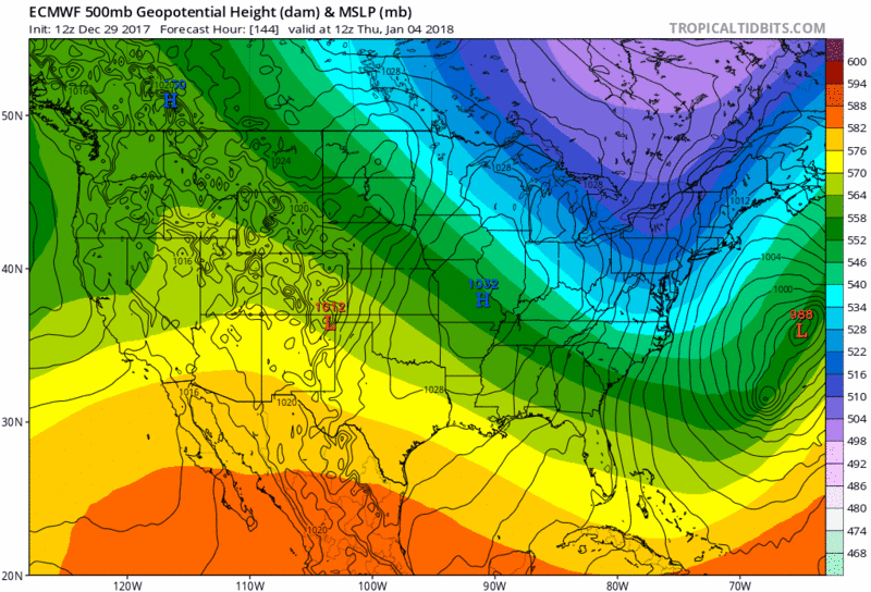
We're in an unfortunate situation. The 500mb level actually looks decent on basically all the models. But it's not giving us anything at the surface. We will not be seeing a low pressure on or inside the BM. Instead, we have to rely on forcing and precip shield enhancement from the UL jet. I'm favoring a glancing blow bringing a light to moderate event for the immediate coast. I don't think this will be a widespread Mothrazilla. It will be confined. Hopefully I'm wrong and we see more drastic changes at the surface.
Frank_Wx- Godzilla Seeker

- Posts : 21305
Join date : 2013-01-05 -

Re: Potential Mothrazilla January 4th-5th
![]() by jimv45 Mon Jan 01, 2018 1:33 pm
by jimv45 Mon Jan 01, 2018 1:33 pm
jimv45- Senior Enthusiast
- Posts : 1168
Reputation : 36
Join date : 2013-09-20
Location : Hopewell jct.
Re: Potential Mothrazilla January 4th-5th
![]() by mikeypizano Mon Jan 01, 2018 1:34 pm
by mikeypizano Mon Jan 01, 2018 1:34 pm

mikeypizano- Pro Enthusiast

- Posts : 1118
Reputation : 66
Join date : 2017-01-05
Age : 35
Location : Wilkes-Barre/Scranton, PA
Re: Potential Mothrazilla January 4th-5th
![]() by rb924119 Mon Jan 01, 2018 1:34 pm
by rb924119 Mon Jan 01, 2018 1:34 pm
skinsfan1177 wrote:rb924119 wrote:EURO looked amazing to me at H5. I think I may have to do a video later this afternoon about this system.....gotta see if time permits.
Rb to me the euro wanted to tug at hour 81 on that low to the west
Agree, strongly.
rb924119- Meteorologist

- Posts : 6890
Reputation : 194
Join date : 2013-02-06
Age : 32
Location : Greentown, Pa
Re: Potential Mothrazilla January 4th-5th
![]() by Quietace Mon Jan 01, 2018 1:35 pm
by Quietace Mon Jan 01, 2018 1:35 pm
Deep thunder is run off the MPAS core which was developed by NCAR and SHOULD HAVE been chosen as the successor core for the GFS (FV3 was chosen instead. Do not get me into that....) TWC(formerly WSI) runs it with there own BL/CP schemes etc. It is all open source.jmanley32 wrote:what model is that?Snow88 wrote:12z Deep Thunder


Quietace- Meteorologist - Mod

- Posts : 3687
Reputation : 33
Join date : 2013-01-07
Age : 27
Location : Point Pleasant, NJ
Re: Potential Mothrazilla January 4th-5th
![]() by Quietace Mon Jan 01, 2018 1:38 pm
by Quietace Mon Jan 01, 2018 1:38 pm
I am fairly confident given prior experiences with similar UL representations that the surface is not being correctly resolved currently.rb924119 wrote:skinsfan1177 wrote:rb924119 wrote:EURO looked amazing to me at H5. I think I may have to do a video later this afternoon about this system.....gotta see if time permits.
Rb to me the euro wanted to tug at hour 81 on that low to the west
Agree, strongly.
Quietace- Meteorologist - Mod
- Posts : 3687
Reputation : 33
Join date : 2013-01-07
Age : 27
Location : Point Pleasant, NJ


Vinnydula- Pro Enthusiast
- Posts : 778
Reputation : 8
Join date : 2013-12-12
Location : Dobbs ferry
Re: Potential Mothrazilla January 4th-5th
![]() by SoulSingMG Mon Jan 01, 2018 1:40 pm
by SoulSingMG Mon Jan 01, 2018 1:40 pm
"I think the models are starting the shift west. I would not be surprised if by Wednesday morning this forecast comes 100-150 miles further west."

SoulSingMG- Senior Enthusiast
- Posts : 2853
Reputation : 74
Join date : 2013-12-11
Location : Long Island City, NY
Re: Potential Mothrazilla January 4th-5th
![]() by Guest Mon Jan 01, 2018 1:42 pm
by Guest Mon Jan 01, 2018 1:42 pm
Frank_Wx wrote:syosnow94 wrote:Frank_Wx wrote:Meh
So did it go west or not. You don’t seem that enthused!
We're in an unfortunate situation. The 500mb level actually looks decent on basically all the models. But it's not giving us anything at the surface. We will not be seeing a low pressure on or inside the BM. Instead, we have to rely on forcing and precip shield enhancement from the UL jet. I'm favoring a glancing blow bringing a light to moderate event for the immediate coast. I don't think this will be a widespread Mothrazilla. It will be confined. Hopefully I'm wrong and we see more drastic changes at the surface.
Wow. I’m surprised to hear you say that! The GEPS mean maps posted on the last page look so good
Guest- Guest
Re: Potential Mothrazilla January 4th-5th
![]() by SoulSingMG Mon Jan 01, 2018 2:00 pm
by SoulSingMG Mon Jan 01, 2018 2:00 pm
SoulSingMG- Senior Enthusiast
- Posts : 2853
Reputation : 74
Join date : 2013-12-11
Location : Long Island City, NY
Re: Potential Mothrazilla January 4th-5th
![]() by Frank_Wx Mon Jan 01, 2018 2:00 pm
by Frank_Wx Mon Jan 01, 2018 2:00 pm
_________________
_______________________________________________________________________________________________________
CLICK HERE to view NJ Strong Snowstorm Classifications

Frank_Wx- Godzilla Seeker
- Posts : 21305
Reputation : 328
Join date : 2013-01-05
Age : 31
Location : Jersey City, NJ -
Re: Potential Mothrazilla January 4th-5th
![]() by sroc4 Mon Jan 01, 2018 2:04 pm
by sroc4 Mon Jan 01, 2018 2:04 pm
’ll reiterate. This is an extremely complex set up. Do not be surprised to see trends to cont up inside of 24-48hrs.”
Plus here is Upton’s very nice summary on the forecast. Notice they bring up an IVT also.
Moderate potential for snow Wed Night into Thursday ..
.. Bitter cold returns for Friday into the Weekend ..
Models continue in good agreement with the polar jet digging down
into the SE US during the midweek, amplifying/sharpening the polar
trough, and interacting with a separate vigorous PAC shortwave
(entering the Northern Rockies this morning) that will be diving
ahead into the southern US. The complexity and uncertainty of the
forecast continues to lie in the evolution of the next piece of PAC
shortwave energy (coming onshore of British Columbia this
morning) and how it digs the polar jet southward and interacts
with the lead shortwave energy. The timing/location of phasing
of the secondary shortwave energy with the initial
shortwave/southern stream energy as they round the base of the
digging trough will be key in track/timing of a explosively
developing northward moving southern low.
It will first be key to amplitude and orientation of the polar
trough. SBU sensitivity analysis indicating that a stronger
secondary shortwave than GEFS/ECMWF ensemble mean will result in a
deeper trough with stronger upstream ridging, resulting in a
resultant explosive low pressure tracking closer to the coast and
likely bringing heavier precip (possible mix coast?) to the area.
While the converse would likely support a farther offshore low, with
less snow for the region.
Secondly, models are hinting at an inverted trough/weak low pressure
development up the Mid-Atlantic coast Wed Night into Thu morning
under right rear of phasing 150 kt northern/southern stream upper
jet and along a strong baroclinic zone, with resultant precip
development streaming up the coast. When the rapid primary low
pressure intensification takes place, it appears that the thermal
forcing and best lift/moisture convergence will tighten towards the
bombing low. Based on current offshore primary low track, an earlier
energy phasing and low intensification would spell less moisture
riding up into the region (GFS), while a slower
phasing/intensification would spell more moisture into the region
(GEM). ECMWF appears to be a good compromise of scenarios.
Taking into account the above scenarios and an operational and
GEFS/ECMWF ensemble consensus, the overall probability for a light
snowfall event is increasing. Have increased pops to chance west and
likely east based on GEFS/ECWMF ensembles probs for 1/10th inch QPF
over the region late Wed Night into early Thu Night. As mentioned in
scenarios above, potential for a heavy snow (mixed precip?) event is
still in play, but a lower probability scenario at this point.
Otherwise...before this storm, a moderation in temps to about 10
degrees below seasonable expected Wednesday ahead of developing
polar trough. After the storm, the hazard once again becomes
the arctic cold. In fact, this could be the coldest air thus
far, with signal for 850 temps of -25 to -30c into the region
for Friday into the weekend. This would likely have temps
struggling to get out of the single digits to lower teens
Fri/Sat, with widespread wind chills of
-10 to -20 degrees early Fri and Sat mornings.
Last edited by sroc4 on Mon Jan 01, 2018 2:07 pm; edited 2 times in total
_________________
"In weather and in life, there's no winning and losing; there's only winning and learning."
WINTER 2012/2013 TOTALS 43.65"WINTER 2017/2018 TOTALS 62.85" WINTER 2022/2023 TOTALS 4.9"
WINTER 2013/2014 TOTALS 64.85"WINTER 2018/2019 TOTALS 14.25" WINTER 2023/2024 TOTALS 13.1"
WINTER 2014/2015 TOTALS 71.20"WINTER 2019/2020 TOTALS 6.35"
WINTER 2015/2016 TOTALS 35.00"WINTER 2020/2021 TOTALS 37.75"
WINTER 2016/2017 TOTALS 42.25"WINTER 2021/2022 TOTALS 31.65"

sroc4- Admin
- Posts : 8331
Reputation : 301
Join date : 2013-01-07
Location : Wading River, LI
Re: Potential Mothrazilla January 4th-5th
![]() by Frank_Wx Mon Jan 01, 2018 2:06 pm
by Frank_Wx Mon Jan 01, 2018 2:06 pm
.png.4aab3a923a3b602ddf0ea162d3c26373.png)
_________________
_______________________________________________________________________________________________________
CLICK HERE to view NJ Strong Snowstorm Classifications
Frank_Wx- Godzilla Seeker
- Posts : 21305
Reputation : 328
Join date : 2013-01-05
Age : 31
Location : Jersey City, NJ -
Re: Potential Mothrazilla January 4th-5th
![]() by jimv45 Mon Jan 01, 2018 2:08 pm
by jimv45 Mon Jan 01, 2018 2:08 pm
jimv45- Senior Enthusiast
- Posts : 1168
Reputation : 36
Join date : 2013-09-20
Location : Hopewell jct.
Re: Potential Mothrazilla January 4th-5th
![]() by Radz Mon Jan 01, 2018 2:11 pm
by Radz Mon Jan 01, 2018 2:11 pm
Frank_Wx wrote:
3,5, and 6 please

Radz- Pro Enthusiast
- Posts : 1028
Reputation : 17
Join date : 2013-01-12
Location : Cortlandt Manor NY
Re: Potential Mothrazilla January 4th-5th
![]() by Guest Mon Jan 01, 2018 2:13 pm
by Guest Mon Jan 01, 2018 2:13 pm
Frank_Wx wrote:
Frank both the control and the mean are over .9” for NYC NO? With ratios this is Godzilla verbatim for areas even 20 miles west of NYC! Am I wrong?
Guest- Guest
Re: Potential Mothrazilla January 4th-5th
![]() by nutleyblizzard Mon Jan 01, 2018 2:17 pm
by nutleyblizzard Mon Jan 01, 2018 2:17 pm
Euro is getting better with each run. Only 150 miles east of benchmark. H5 levels argued for a closer approach. With better sampling tonight and tomorrow, I have a hunch things will get very interesting!

nutleyblizzard- Senior Enthusiast
- Posts : 1952
Reputation : 41
Join date : 2014-01-30
Age : 58
Location : Nutley, new jersey
Re: Potential Mothrazilla January 4th-5th
![]() by Frank_Wx Mon Jan 01, 2018 2:20 pm
by Frank_Wx Mon Jan 01, 2018 2:20 pm
_________________
_______________________________________________________________________________________________________
CLICK HERE to view NJ Strong Snowstorm Classifications
Frank_Wx- Godzilla Seeker
- Posts : 21305
Reputation : 328
Join date : 2013-01-05
Age : 31
Location : Jersey City, NJ -
Re: Potential Mothrazilla January 4th-5th
![]() by Frank_Wx Mon Jan 01, 2018 2:20 pm
by Frank_Wx Mon Jan 01, 2018 2:20 pm

_________________
_______________________________________________________________________________________________________
CLICK HERE to view NJ Strong Snowstorm Classifications
Frank_Wx- Godzilla Seeker
- Posts : 21305
Reputation : 328
Join date : 2013-01-05
Age : 31
Location : Jersey City, NJ -
Re: Potential Mothrazilla January 4th-5th
![]() by amugs Mon Jan 01, 2018 2:26 pm
by amugs Mon Jan 01, 2018 2:26 pm
SROC so true - we have seen this so many times with our coastal lows over the decasdes ho wthey trend inside 48 hours.
Nuts we are seeing the push west on the EURO - still need that turd of a kicker to go away, slow down or the Southern Vort stay open an dthen close off at the VA CAPES and we get what everyone hopes and prays for around here.
_________________
Mugs
AKA:King: Snow Weenie
Self Proclaimed
WINTER 2014-15 : 55.12" +.02 for 6 coatings (avg. 35")
WINTER 2015-16 Total - 29.8" (Avg 35")
WINTER 2016-17 : 39.5" so far

amugs- Advanced Forecaster - Mod

- Posts : 15093
Reputation : 213
Join date : 2013-01-07
Age : 54
Location : Hillsdale,NJ
Re: Potential Mothrazilla January 4th-5th
![]() by Quietace Mon Jan 01, 2018 2:32 pm
by Quietace Mon Jan 01, 2018 2:32 pm
It is 5 o clock somewhere right? lolFrank_Wx wrote:Euro ensembles are a glancing blow again but I think there are several west leaning members. This system is giving me agita.
Quietace- Meteorologist - Mod
- Posts : 3687
Reputation : 33
Join date : 2013-01-07
Age : 27
Location : Point Pleasant, NJ
Re: Potential Mothrazilla January 4th-5th
![]() by nutleyblizzard Mon Jan 01, 2018 2:40 pm
by nutleyblizzard Mon Jan 01, 2018 2:40 pm

GEPS ensembles. Many members are inside the benchmark.
nutleyblizzard- Senior Enthusiast
- Posts : 1952
Reputation : 41
Join date : 2014-01-30
Age : 58
Location : Nutley, new jersey
Re: Potential Mothrazilla January 4th-5th
![]() by SoulSingMG Mon Jan 01, 2018 2:50 pm
by SoulSingMG Mon Jan 01, 2018 2:50 pm
Are these in range??

SoulSingMG- Senior Enthusiast
- Posts : 2853
Reputation : 74
Join date : 2013-12-11
Location : Long Island City, NY
Re: Potential Mothrazilla January 4th-5th
![]() by Sanchize06 Mon Jan 01, 2018 2:54 pm
by Sanchize06 Mon Jan 01, 2018 2:54 pm
SoulSingMG wrote:Okay, sooooo............
Are these in range??
Wow, that's even better than 9z
Sanchize06- Senior Enthusiast
- Posts : 1041
Reputation : 21
Join date : 2013-02-05
Location : Union Beach, NJ
Re: Potential Mothrazilla January 4th-5th
![]() by Carter bk Mon Jan 01, 2018 2:55 pm
by Carter bk Mon Jan 01, 2018 2:55 pm
Carter bk- Posts : 73
Reputation : 5
Join date : 2017-12-07
Re: Potential Mothrazilla January 4th-5th
![]() by lglickman1 Mon Jan 01, 2018 3:07 pm
by lglickman1 Mon Jan 01, 2018 3:07 pm
lglickman1- Pro Enthusiast
- Posts : 319
Reputation : 0
Join date : 2013-02-05
Location : New Rochelle, NY
Page 14 of 39 • 1 ... 8 ... 13, 14, 15 ... 26 ... 39 ![]()
|
|
|