
 Search
January 4th Snowstorm: 1st Call Snow Map
Page 3 of 18 •  1, 2, 3, 4 ... 10 ... 18
 ![]()
Re: January 4th Snowstorm: 1st Call Snow Map
![]() by SoulSingMG Wed Jan 03, 2018 1:39 am
by SoulSingMG Wed Jan 03, 2018 1:39 am
"So, maybe this Nor'easter will bury somebody after all in snowfall. We'll see what the EPS ensembles say about the "precip shield" westward shift -- and if it will keep shifting west. The bust-o-matic dial is starting to fidget."
SoulSingMG- Senior Enthusiast

- Posts : 2853
Join date : 2013-12-11
Re: January 4th Snowstorm: 1st Call Snow Map
![]() by rb924119 Wed Jan 03, 2018 2:20 am
by rb924119 Wed Jan 03, 2018 2:20 am
rb924119- Meteorologist

- Posts : 6928
Join date : 2013-02-06
Re: January 4th Snowstorm: 1st Call Snow Map
![]() by NjWeatherGuy Wed Jan 03, 2018 2:39 am
by NjWeatherGuy Wed Jan 03, 2018 2:39 am

NjWeatherGuy- Advanced Forecaster

- Posts : 4100
Reputation : 28
Join date : 2013-01-06
Location : Belle Mead, NJ
Re: January 4th Snowstorm: 1st Call Snow Map
![]() by NjWeatherGuy Wed Jan 03, 2018 2:43 am
by NjWeatherGuy Wed Jan 03, 2018 2:43 am
NjWeatherGuy- Advanced Forecaster
- Posts : 4100
Reputation : 28
Join date : 2013-01-06
Location : Belle Mead, NJ
Re: January 4th Snowstorm: 1st Call Snow Map
![]() by SoulSingMG Wed Jan 03, 2018 3:15 am
by SoulSingMG Wed Jan 03, 2018 3:15 am
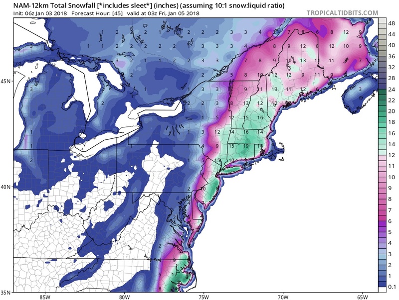
The 06z NAM!!!!!

SoulSingMG- Senior Enthusiast
- Posts : 2853
Reputation : 74
Join date : 2013-12-11
Location : Long Island City, NY
Re: January 4th Snowstorm: 1st Call Snow Map
![]() by weatherwatchermom Wed Jan 03, 2018 3:17 am
by weatherwatchermom Wed Jan 03, 2018 3:17 am

weatherwatchermom- Senior Enthusiast
- Posts : 3793
Reputation : 78
Join date : 2014-11-25
Location : Hazlet Township, NJ
Re: January 4th Snowstorm: 1st Call Snow Map
![]() by SoulSingMG Wed Jan 03, 2018 3:18 am
by SoulSingMG Wed Jan 03, 2018 3:18 am
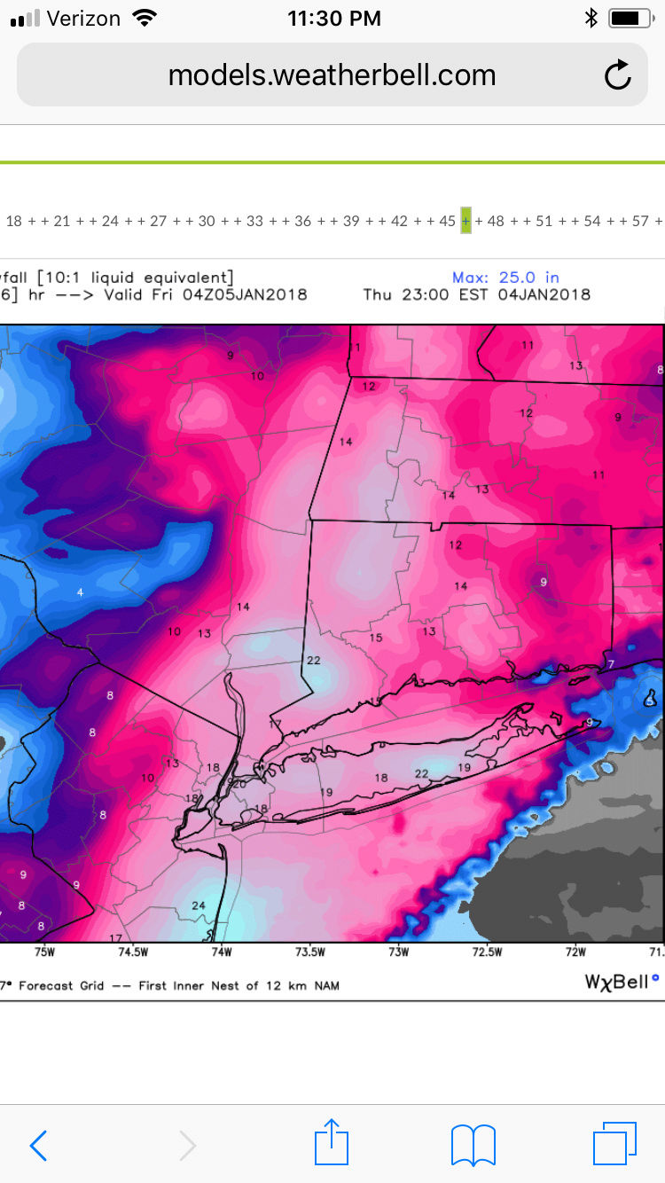
Hearing the 3K running now may be even CRAZIER.
SoulSingMG- Senior Enthusiast
- Posts : 2853
Reputation : 74
Join date : 2013-12-11
Location : Long Island City, NY
Re: January 4th Snowstorm: 1st Call Snow Map
![]() by Smitty623 Wed Jan 03, 2018 3:20 am
by Smitty623 Wed Jan 03, 2018 3:20 am
Smitty623- Posts : 22
Reputation : 4
Join date : 2018-01-02
Re: January 4th Snowstorm: 1st Call Snow Map
![]() by weatherwatchermom Wed Jan 03, 2018 3:21 am
by weatherwatchermom Wed Jan 03, 2018 3:21 am
weatherwatchermom- Senior Enthusiast
- Posts : 3793
Reputation : 78
Join date : 2014-11-25
Location : Hazlet Township, NJ
Re: January 4th Snowstorm: 1st Call Snow Map
![]() by weatherwatchermom Wed Jan 03, 2018 3:22 am
by weatherwatchermom Wed Jan 03, 2018 3:22 am
Last edited by weatherwatchermom on Wed Jan 03, 2018 3:24 am; edited 1 time in total
weatherwatchermom- Senior Enthusiast
- Posts : 3793
Reputation : 78
Join date : 2014-11-25
Location : Hazlet Township, NJ
Re: January 4th Snowstorm: 1st Call Snow Map
![]() by NjWeatherGuy Wed Jan 03, 2018 3:22 am
by NjWeatherGuy Wed Jan 03, 2018 3:22 am
NjWeatherGuy- Advanced Forecaster
- Posts : 4100
Reputation : 28
Join date : 2013-01-06
Location : Belle Mead, NJ
Re: January 4th Snowstorm: 1st Call Snow Map
![]() by NjWeatherGuy Wed Jan 03, 2018 3:23 am
by NjWeatherGuy Wed Jan 03, 2018 3:23 am
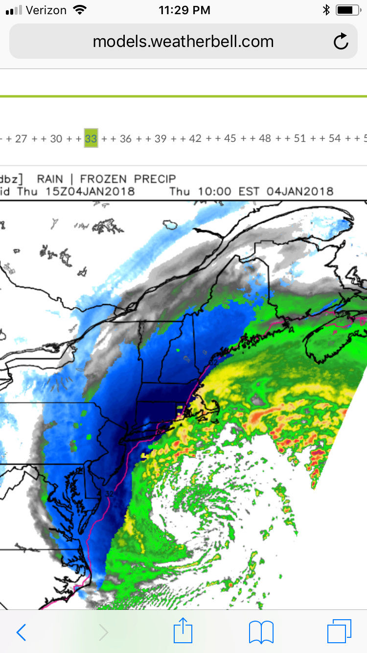
https://www.tropicaltidbits.com/analysis/models/?model=nam3km®ion=neus&pkg=mslp_pcpn_frzn&runtime=2018010306&fh=28&xpos=0&ypos=0
NjWeatherGuy- Advanced Forecaster
- Posts : 4100
Reputation : 28
Join date : 2013-01-06
Location : Belle Mead, NJ
Re: January 4th Snowstorm: 1st Call Snow Map
![]() by SoulSingMG Wed Jan 03, 2018 3:24 am
by SoulSingMG Wed Jan 03, 2018 3:24 am
NjWeatherGuy wrote:Looks like the NAM is gonna do it for us. I've learned not to put all my chips in when it's just the NAM, but it got blizz 2016. Hopefully it's a continuation of the trend. Very good sign! Leggo!
Unreal! It's literally a crippling blizzard on that run! I'm so happy (for now lol)
SoulSingMG- Senior Enthusiast
- Posts : 2853
Reputation : 74
Join date : 2013-12-11
Location : Long Island City, NY
Re: January 4th Snowstorm: 1st Call Snow Map
![]() by NjWeatherGuy Wed Jan 03, 2018 3:25 am
by NjWeatherGuy Wed Jan 03, 2018 3:25 am
NjWeatherGuy- Advanced Forecaster
- Posts : 4100
Reputation : 28
Join date : 2013-01-06
Location : Belle Mead, NJ
Re: January 4th Snowstorm: 1st Call Snow Map
![]() by SoulSingMG Wed Jan 03, 2018 3:26 am
by SoulSingMG Wed Jan 03, 2018 3:26 am
SoulSingMG- Senior Enthusiast
- Posts : 2853
Reputation : 74
Join date : 2013-12-11
Location : Long Island City, NY
Re: January 4th Snowstorm: 1st Call Snow Map
![]() by weatherwatchermom Wed Jan 03, 2018 3:27 am
by weatherwatchermom Wed Jan 03, 2018 3:27 am
weatherwatchermom- Senior Enthusiast
- Posts : 3793
Reputation : 78
Join date : 2014-11-25
Location : Hazlet Township, NJ
hurrysundown23- Posts : 53
Reputation : 1
Join date : 2017-01-04
Location : Sayreville, NJ
Re: January 4th Snowstorm: 1st Call Snow Map
![]() by SoulSingMG Wed Jan 03, 2018 3:30 am
by SoulSingMG Wed Jan 03, 2018 3:30 am
SoulSingMG- Senior Enthusiast
- Posts : 2853
Reputation : 74
Join date : 2013-12-11
Location : Long Island City, NY
Re: January 4th Snowstorm: 1st Call Snow Map
![]() by hurrysundown23 Wed Jan 03, 2018 3:31 am
by hurrysundown23 Wed Jan 03, 2018 3:31 am
Well, this storm has a lot of similarities to the Boxer Day storm where the global models just were not handling the interaction of shortwaves very well. When I compare the shortwaves via the observations like satellite pictures and upper-level soundings, the overall solution to me gives more support with a complete phase of the two shortwaves diving towards the Mississippi River Valley this afternoon. If the complete phase happens as seen on the NAM, RGEM, SREF, and RPM; than the forecast above would be the result. If the phase is not complete and a piece of this storm is able to jump further east, then the whole precipitation shield ends up mostly off the coast and snowfall totals are cut in half.
In a case like this, I rather forecast high and than lower as to not put people in harm’s way. Images of people trapped on a highway in a blizzard do not sit well with me here. So I rather go high than try to be perfect, even though I rather always be perfect with my forecasting.
Regardless of track, the wind impacts are a significant concern especially along the coast but even over the interior. Aside from windchills being in the single digits and teens at the height of the storm on Thursday morning, visibility is likely to fall below 2 miles. The strong winds at 20 to 40 mph sustained along the coast with gusts over 50 mph at times, will also support the potential for power outages and minor to moderate wind damage. There is a concern for coastal flooding and also a unique concern with the ice that has formed in many bays around the region. The strong winds and tidal action may drive large areas of ice into structures along the coast, which could be a problem for boats and other structural features.
The forecast for this storm is highly volatile and changes are likely. Over the next 24 hours, the forecast for this storm will hopefully come in line and a final forecast is expected by tomorrow afternoon as we watch the storm begin to form off the Southeast coast. My advice is to be prepared and hope for the best, which is an incomplete phase and a track to the east-northeast.
hurrysundown23- Posts : 53
Reputation : 1
Join date : 2017-01-04
Location : Sayreville, NJ
Re: January 4th Snowstorm: 1st Call Snow Map
![]() by hurrysundown23 Wed Jan 03, 2018 3:32 am
by hurrysundown23 Wed Jan 03, 2018 3:32 am
hurrysundown23- Posts : 53
Reputation : 1
Join date : 2017-01-04
Location : Sayreville, NJ
Re: January 4th Snowstorm: 1st Call Snow Map
![]() by weatherwatchermom Wed Jan 03, 2018 3:39 am
by weatherwatchermom Wed Jan 03, 2018 3:39 am
weatherwatchermom- Senior Enthusiast
- Posts : 3793
Reputation : 78
Join date : 2014-11-25
Location : Hazlet Township, NJ
Re: January 4th Snowstorm: 1st Call Snow Map
![]() by weatherwatchermom Wed Jan 03, 2018 3:40 am
by weatherwatchermom Wed Jan 03, 2018 3:40 am
weatherwatchermom- Senior Enthusiast
- Posts : 3793
Reputation : 78
Join date : 2014-11-25
Location : Hazlet Township, NJ
Re: January 4th Snowstorm: 1st Call Snow Map
![]() by SoulSingMG Wed Jan 03, 2018 4:01 am
by SoulSingMG Wed Jan 03, 2018 4:01 am
SoulSingMG- Senior Enthusiast
- Posts : 2853
Reputation : 74
Join date : 2013-12-11
Location : Long Island City, NY
Re: January 4th Snowstorm: 1st Call Snow Map
![]() by sroc4 Wed Jan 03, 2018 4:04 am
by sroc4 Wed Jan 03, 2018 4:04 am
_________________
"In weather and in life, there's no winning and losing; there's only winning and learning."
WINTER 2012/2013 TOTALS 43.65"WINTER 2017/2018 TOTALS 62.85" WINTER 2022/2023 TOTALS 4.9"
WINTER 2013/2014 TOTALS 64.85"WINTER 2018/2019 TOTALS 14.25" WINTER 2023/2024 TOTALS 13.1"
WINTER 2014/2015 TOTALS 71.20"WINTER 2019/2020 TOTALS 6.35"
WINTER 2015/2016 TOTALS 35.00"WINTER 2020/2021 TOTALS 37.75"
WINTER 2016/2017 TOTALS 42.25"WINTER 2021/2022 TOTALS 31.65"

sroc4- Admin

- Posts : 8354
Reputation : 302
Join date : 2013-01-07
Location : Wading River, LI
Re: January 4th Snowstorm: 1st Call Snow Map
![]() by sroc4 Wed Jan 03, 2018 4:31 am
by sroc4 Wed Jan 03, 2018 4:31 am
_________________
"In weather and in life, there's no winning and losing; there's only winning and learning."
WINTER 2012/2013 TOTALS 43.65"WINTER 2017/2018 TOTALS 62.85" WINTER 2022/2023 TOTALS 4.9"
WINTER 2013/2014 TOTALS 64.85"WINTER 2018/2019 TOTALS 14.25" WINTER 2023/2024 TOTALS 13.1"
WINTER 2014/2015 TOTALS 71.20"WINTER 2019/2020 TOTALS 6.35"
WINTER 2015/2016 TOTALS 35.00"WINTER 2020/2021 TOTALS 37.75"
WINTER 2016/2017 TOTALS 42.25"WINTER 2021/2022 TOTALS 31.65"
sroc4- Admin
- Posts : 8354
Reputation : 302
Join date : 2013-01-07
Location : Wading River, LI
Re: January 4th Snowstorm: 1st Call Snow Map
![]() by skinsfan1177 Wed Jan 03, 2018 4:37 am
by skinsfan1177 Wed Jan 03, 2018 4:37 am
sroc4 wrote:3k NAM. Cp. you should be waking right about now. If the NAM is correct MADONNE!
Wow that's at 10:1 it be more like 15:1 that's 3 feet here

skinsfan1177- Senior Enthusiast
- Posts : 4485
Reputation : 35
Join date : 2013-01-07
Age : 46
Location : Point Pleasant Boro
oldtimer- Senior Enthusiast
- Posts : 1103
Reputation : 14
Join date : 2013-01-16
Age : 78
Location : Port Jefferson Station Suffolk County
Page 3 of 18 • 1, 2, 3, 4 ... 10 ... 18 ![]()
|
|
|