
 Search
FEB 7th 2018---Front End Thump
Page 1 of 8 • 1, 2, 3, 4, 5, 6, 7, 8 ![]()

FEB 7th 2018---Front End Thump
![]() by sroc4 Mon Feb 05, 2018 12:18 pm
by sroc4 Mon Feb 05, 2018 12:18 pm


_________________
"In weather and in life, there's no winning and losing; there's only winning and learning."
WINTER 2012/2013 TOTALS 43.65"WINTER 2017/2018 TOTALS 62.85" WINTER 2022/2023 TOTALS 4.9"
WINTER 2013/2014 TOTALS 64.85"WINTER 2018/2019 TOTALS 14.25" WINTER 2023/2024 TOTALS 13.1"
WINTER 2014/2015 TOTALS 71.20"WINTER 2019/2020 TOTALS 6.35"
WINTER 2015/2016 TOTALS 35.00"WINTER 2020/2021 TOTALS 37.75"
WINTER 2016/2017 TOTALS 42.25"WINTER 2021/2022 TOTALS 31.65"

sroc4- Admin

- Posts : 8441
Reputation : 302
Join date : 2013-01-07
Location : Wading River, LI
Re: FEB 7th 2018---Front End Thump
![]() by aiannone Mon Feb 05, 2018 12:26 pm
by aiannone Mon Feb 05, 2018 12:26 pm
_________________
-Alex Iannone-

aiannone- Senior Enthusiast - Mod

- Posts : 4822
Reputation : 92
Join date : 2013-01-07
Location : Saint James, LI (Northwest Suffolk Co.)
Re: FEB 7th 2018---Front End Thump
![]() by jimv45 Mon Feb 05, 2018 12:27 pm
by jimv45 Mon Feb 05, 2018 12:27 pm
jimv45- Senior Enthusiast

- Posts : 1168
Reputation : 36
Join date : 2013-09-20
Location : Hopewell jct.
Re: FEB 7th 2018---Front End Thump
![]() by hyde345 Mon Feb 05, 2018 12:39 pm
by hyde345 Mon Feb 05, 2018 12:39 pm
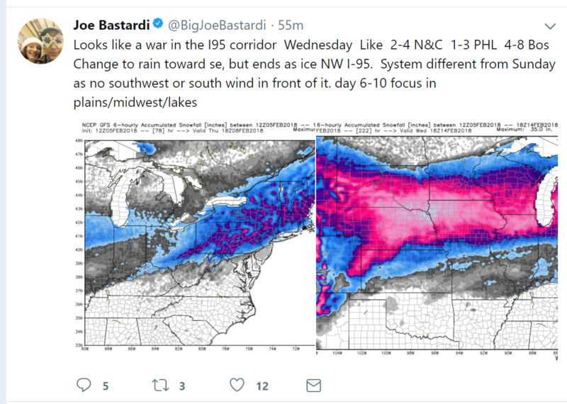
jimv45 wrote:Looks like a tough go up north with snow sleet and some freezing rain. Right now i would say a good 3-6 for us northern folks.
Jim, I think this a safe bet for us north of 84 and more the further north you go. Albany is looking in the 8-10 range.

hyde345- Pro Enthusiast

- Posts : 1082
Reputation : 48
Join date : 2013-01-08
Location : Hyde Park, NY
Re: FEB 7th 2018---Front End Thump
![]() by jimv45 Mon Feb 05, 2018 12:45 pm
by jimv45 Mon Feb 05, 2018 12:45 pm
jimv45- Senior Enthusiast
- Posts : 1168
Reputation : 36
Join date : 2013-09-20
Location : Hopewell jct.
Re: FEB 7th 2018---Front End Thump
![]() by Guest Mon Feb 05, 2018 12:54 pm
by Guest Mon Feb 05, 2018 12:54 pm
Guest- Guest
Re: FEB 7th 2018---Front End Thump
![]() by amugs Mon Feb 05, 2018 1:05 pm
by amugs Mon Feb 05, 2018 1:05 pm

Nina Esque Storm
_________________
Mugs
AKA:King: Snow Weenie
Self Proclaimed
WINTER 2014-15 : 55.12" +.02 for 6 coatings (avg. 35")
WINTER 2015-16 Total - 29.8" (Avg 35")
WINTER 2016-17 : 39.5" so far

amugs- Advanced Forecaster - Mod
- Posts : 15130
Reputation : 213
Join date : 2013-01-07
Age : 54
Location : Hillsdale,NJ

Guest- Guest
Re: FEB 7th 2018---Front End Thump
![]() by aiannone Mon Feb 05, 2018 1:41 pm
by aiannone Mon Feb 05, 2018 1:41 pm
_________________
-Alex Iannone-
aiannone- Senior Enthusiast - Mod
- Posts : 4822
Reputation : 92
Join date : 2013-01-07
Location : Saint James, LI (Northwest Suffolk Co.)
Re: FEB 7th 2018---Front End Thump
![]() by essexcountypete Mon Feb 05, 2018 1:57 pm
by essexcountypete Mon Feb 05, 2018 1:57 pm

essexcountypete- Pro Enthusiast
- Posts : 783
Reputation : 12
Join date : 2013-12-09
Location : Bloomfield, NJ
Re: FEB 7th 2018---Front End Thump
![]() by aiannone Mon Feb 05, 2018 2:31 pm
by aiannone Mon Feb 05, 2018 2:31 pm
_________________
-Alex Iannone-
aiannone- Senior Enthusiast - Mod
- Posts : 4822
Reputation : 92
Join date : 2013-01-07
Location : Saint James, LI (Northwest Suffolk Co.)
Re: FEB 7th 2018---Front End Thump
![]() by jimv45 Mon Feb 05, 2018 3:20 pm
by jimv45 Mon Feb 05, 2018 3:20 pm
jimv45- Senior Enthusiast
- Posts : 1168
Reputation : 36
Join date : 2013-09-20
Location : Hopewell jct.
Re: FEB 7th 2018---Front End Thump
![]() by docstox12 Mon Feb 05, 2018 3:22 pm
by docstox12 Mon Feb 05, 2018 3:22 pm

docstox12- Wx Statistician Guru

- Posts : 8589
Reputation : 222
Join date : 2013-01-07
Age : 73
Location : Monroe NY
Re: FEB 7th 2018---Front End Thump
![]() by aiannone Mon Feb 05, 2018 3:23 pm
by aiannone Mon Feb 05, 2018 3:23 pm
https://www.accuweather.com/en/videos/snow-and-ice-storm-coming-to-the-northeast/f4bzi5yte6o0cnlleinxd2ssq527igk4
_________________
-Alex Iannone-
aiannone- Senior Enthusiast - Mod
- Posts : 4822
Reputation : 92
Join date : 2013-01-07
Location : Saint James, LI (Northwest Suffolk Co.)
Re: FEB 7th 2018---Front End Thump
![]() by jimv45 Mon Feb 05, 2018 3:27 pm
by jimv45 Mon Feb 05, 2018 3:27 pm
jimv45- Senior Enthusiast
- Posts : 1168
Reputation : 36
Join date : 2013-09-20
Location : Hopewell jct.
Re: FEB 7th 2018---Front End Thump
![]() by docstox12 Mon Feb 05, 2018 3:54 pm
by docstox12 Mon Feb 05, 2018 3:54 pm
docstox12- Wx Statistician Guru
- Posts : 8589
Reputation : 222
Join date : 2013-01-07
Age : 73
Location : Monroe NY
Re: FEB 7th 2018---Front End Thump
![]() by docstox12 Mon Feb 05, 2018 3:55 pm
by docstox12 Mon Feb 05, 2018 3:55 pm
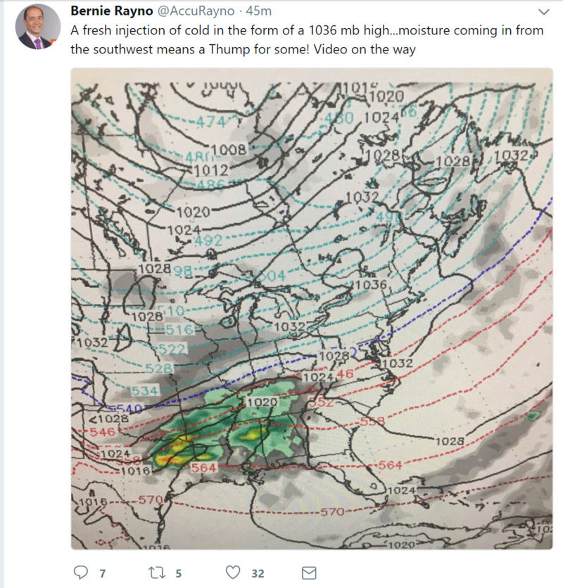
aiannone wrote:Great video by Bernie. Explains how with a fresh injection of cold air coming in tomorrow in the wake of a weakening piece of energy, 540 line is NOT your r/s line. It will be more like the 545-550 line as wet bulb temps will be very cold. Says this cold air will be hard to budge and NYC and the coast could see 1-3" before the changeover even down to DC. Take a listen!
https://www.accuweather.com/en/videos/snow-and-ice-storm-coming-to-the-northeast/f4bzi5yte6o0cnlleinxd2ssq527igk4
Great video by Bernie and I hope that cold air wins out and hangs tough.Hoping for a favorable move of the storm itself to get into the heavy snow up in the HV.
docstox12- Wx Statistician Guru
- Posts : 8589
Reputation : 222
Join date : 2013-01-07
Age : 73
Location : Monroe NY
Re: FEB 7th 2018---Front End Thump
![]() by amugs Mon Feb 05, 2018 4:55 pm
by amugs Mon Feb 05, 2018 4:55 pm


_________________
Mugs
AKA:King: Snow Weenie
Self Proclaimed
WINTER 2014-15 : 55.12" +.02 for 6 coatings (avg. 35")
WINTER 2015-16 Total - 29.8" (Avg 35")
WINTER 2016-17 : 39.5" so far
amugs- Advanced Forecaster - Mod
- Posts : 15130
Reputation : 213
Join date : 2013-01-07
Age : 54
Location : Hillsdale,NJ
Re: FEB 7th 2018---Front End Thump
![]() by Guest Mon Feb 05, 2018 5:25 pm
by Guest Mon Feb 05, 2018 5:25 pm
Guest- Guest
Re: FEB 7th 2018---Front End Thump
![]() by sroc4 Mon Feb 05, 2018 5:48 pm
by sroc4 Mon Feb 05, 2018 5:48 pm
TheAresian wrote:Winter storm watch is up for me way off to the northwest. They're calling for 5 to 9, but the way this winter has gone so far I fully expect the storm to either bust low or slide off to the south and east. My prediction: 1"-3".
Im really pulling for you interior folks. I think you will get your 6 inches. If we weren't on a public forum and if we were close buddies I prob would run with that last statement but since its a PG thread Ill leave it at that.
_________________
"In weather and in life, there's no winning and losing; there's only winning and learning."
WINTER 2012/2013 TOTALS 43.65"WINTER 2017/2018 TOTALS 62.85" WINTER 2022/2023 TOTALS 4.9"
WINTER 2013/2014 TOTALS 64.85"WINTER 2018/2019 TOTALS 14.25" WINTER 2023/2024 TOTALS 13.1"
WINTER 2014/2015 TOTALS 71.20"WINTER 2019/2020 TOTALS 6.35"
WINTER 2015/2016 TOTALS 35.00"WINTER 2020/2021 TOTALS 37.75"
WINTER 2016/2017 TOTALS 42.25"WINTER 2021/2022 TOTALS 31.65"
sroc4- Admin
- Posts : 8441
Reputation : 302
Join date : 2013-01-07
Location : Wading River, LI
Re: FEB 7th 2018---Front End Thump
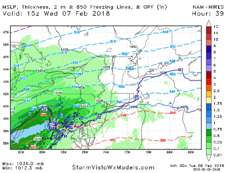
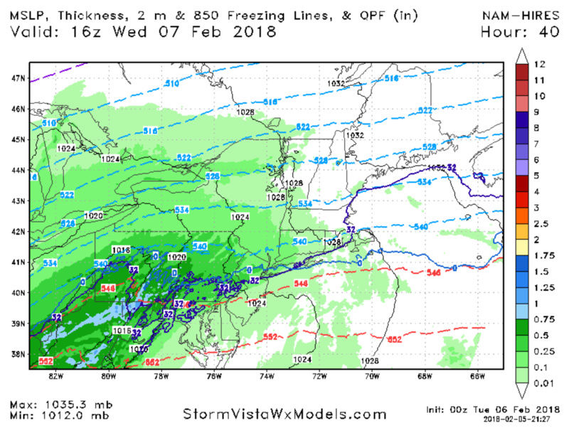
![]() by Frank_Wx Mon Feb 05, 2018 6:23 pm
by Frank_Wx Mon Feb 05, 2018 6:23 pm
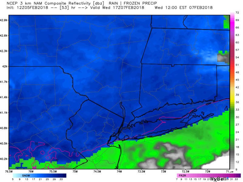
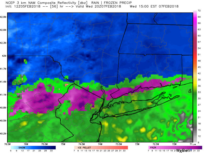
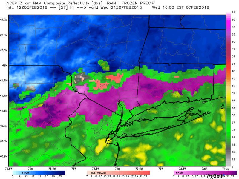
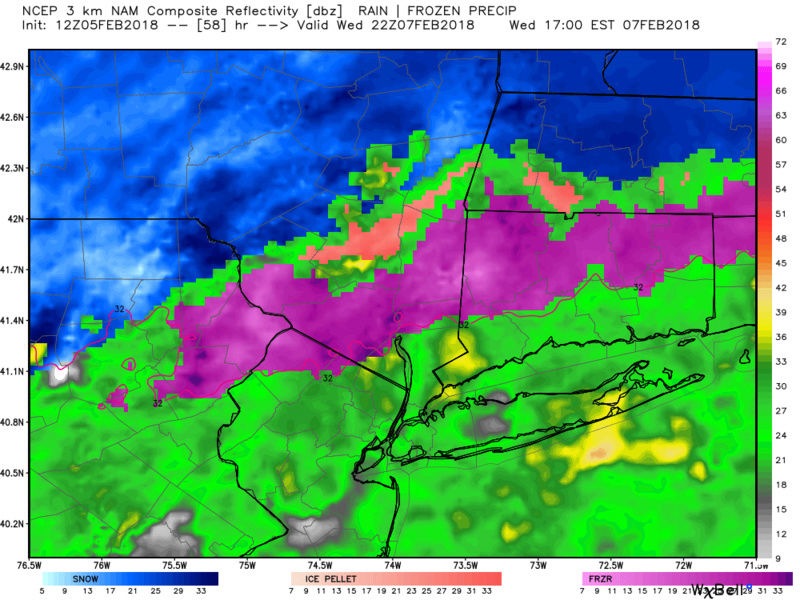
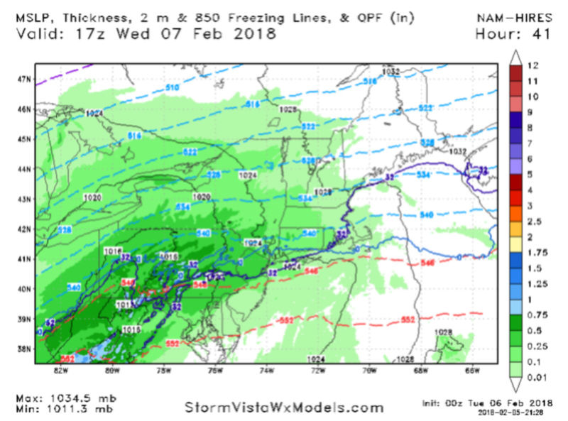
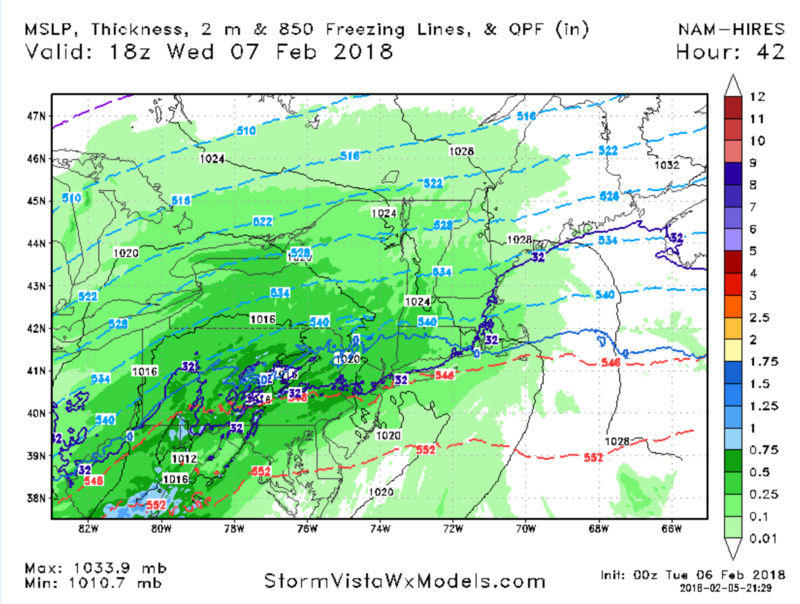
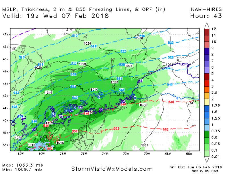
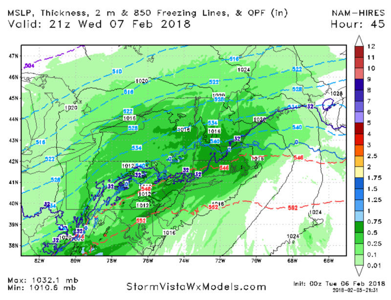
This is the coldest frame of the 18z NAM for the coaat

Looks like a C-1 inch of snow then a period of icing before changing to rain. N&W of NYC I can see you getting 2 to 4 inches, with some spot up to 6. As you head north from there you will hit 6"+ amounts.
Be careful traveling Wednesday at the onset. Looks like a mid morning start time
_________________
_______________________________________________________________________________________________________
CLICK HERE to view NJ Strong Snowstorm Classifications

Frank_Wx- Godzilla Seeker
- Posts : 21308
Reputation : 328
Join date : 2013-01-05
Age : 32
Location : Jersey City, NJ -

Re: FEB 7th 2018---Front End Thump
![]() by rb924119 Mon Feb 05, 2018 8:44 pm
by rb924119 Mon Feb 05, 2018 8:44 pm
rb924119- Meteorologist

- Posts : 7033
Reputation : 195
Join date : 2013-02-06
Age : 32
Location : Greentown, Pa
Re: FEB 7th 2018---Front End Thump
![]() by Math23x7 Mon Feb 05, 2018 9:37 pm
by Math23x7 Mon Feb 05, 2018 9:37 pm
Math23x7- Wx Statistician Guru
- Posts : 2382
Reputation : 68
Join date : 2013-01-08
Re: FEB 7th 2018---Front End Thump
![]() by amugs Mon Feb 05, 2018 9:41 pm
by amugs Mon Feb 05, 2018 9:41 pm
Math23x7 wrote:The NW short-range trend continues. 0Z NAM much warmer with this system...
Not so much for the Hi RES there Mikey!!

_________________
Mugs
AKA:King: Snow Weenie
Self Proclaimed
WINTER 2014-15 : 55.12" +.02 for 6 coatings (avg. 35")
WINTER 2015-16 Total - 29.8" (Avg 35")
WINTER 2016-17 : 39.5" so far
amugs- Advanced Forecaster - Mod
- Posts : 15130
Reputation : 213
Join date : 2013-01-07
Age : 54
Location : Hillsdale,NJ
Re: FEB 7th 2018---Front End Thump
![]() by aiannone Mon Feb 05, 2018 9:42 pm
by aiannone Mon Feb 05, 2018 9:42 pm
_________________
-Alex Iannone-
aiannone- Senior Enthusiast - Mod
- Posts : 4822
Reputation : 92
Join date : 2013-01-07
Location : Saint James, LI (Northwest Suffolk Co.)
Page 1 of 8 • 1, 2, 3, 4, 5, 6, 7, 8 ![]()
|
|
|