March 7th-8th 2018 Storm Potential
+40
mmanisca
crippo84
Scullybutcher
deadrabbit79
SnowForest
Carter bk
mikeypizano
essexcountypete
DAYBLAZER
jimv45
Dunnzoo
docstox12
SENJsnowman
Grselig
Radz
frank 638
skinsfan1177
RJB8525
algae888
Math23x7
Sanchize06
CPcantmeasuresnow
Frank_Wx
adamfitz1969
rb924119
billg315
Snow88
WeatherBob
Vinnydula
hurrysundown23
Quietace
track17
aiannone
nutleyblizzard
SoulSingMG
jmanley32
weatherwatchermom
snowday111
amugs
sroc4
44 posters
Page 5 of 19
Page 5 of 19 •  1, 2, 3, 4, 5, 6 ... 12 ... 19
 Re: March 7th-8th 2018 Storm Potential
. Too early to throw in the towel Track. Give it till this time tomorrow night.track17 wrote:Not gonna happen syo I am done with this storm drew me in but horrible set up for my area
Guest- Guest
 Re: March 7th-8th 2018 Storm Potential
I don’t see any real temp issues away from the coast and the storm seems to be ramping up as it comes up the coast. This is why I like it when the low develops further south around NC or VA. They usually hit peak intensity just as they get off the NJ coast. When they develop further north it’s acrace against time for intensification.
billg315- Advanced Forecaster - Mod

- Posts : 4483
Join date : 2015-01-24
 Re: March 7th-8th 2018 Storm Potential
You in westchester? You need put your location so they know where your talking about when making reports. yes I agree, while the winds were wild, I was not happy we saw no accumulating snow.adamfitz1969 wrote:jmanley32 wrote:Oh baby I stay all snow and heavy at that on NAM!!
We "deserve" this one Jmanley, we were left in the wind last event. And to think, the finale "performance has earmarks of it being bigger.

jmanley32- Senior Enthusiast

- Posts : 20535
Reputation : 108
Join date : 2013-12-12
Age : 43
Location : Yonkers, NY
 Re: March 7th-8th 2018 Storm Potential
100% correct syo, lets reel it in and to think theres the possibility of another even bigger storm on the 12th ha! march is the new winter. I hope it works pout for all of us. Be night to see the godzilla hoisted here dare I say roidzilla? Some of those totals are nearing that level, could the block slow this bad boy down anymore guys and just sit like the last did?syosnow94 wrote:I actually love the fact we’re just under 3 days out and today the models trended west. That gives us another 36 hours for the models to windshield wiper back east 100 miles or so and we all get creamed

jmanley32- Senior Enthusiast

- Posts : 20535
Reputation : 108
Join date : 2013-12-12
Age : 43
Location : Yonkers, NY
 Re: March 7th-8th 2018 Storm Potential
I do hope it trends just a tad east so the jersey shore and LI get into the big totals. But I think even if rain mixes in for coastal areas it will go back to snow there as the low pulls north.

billg315- Advanced Forecaster - Mod

- Posts : 4483
Reputation : 185
Join date : 2015-01-24
Age : 50
Location : Flemington, NJ
 Re: March 7th-8th 2018 Storm Potential
I would rather see nothing in that setting bling it never changes over and sticks. Us folks here are done that is fine I am ready for hurricane season
track17- Posts : 454
Reputation : 4
Join date : 2016-01-09
 Re: March 7th-8th 2018 Storm Potential
There may be some good dynamics with this but I really hope its not as crazy all over the place as friday.billg315 wrote:I do hope it trends just a tad east so the jersey shore and LI get into the big totals. But I think even if rain mixes in for coastal areas it will go back to snow there as the low pulls north.

jmanley32- Senior Enthusiast

- Posts : 20535
Reputation : 108
Join date : 2013-12-12
Age : 43
Location : Yonkers, NY
 Re: March 7th-8th 2018 Storm Potential
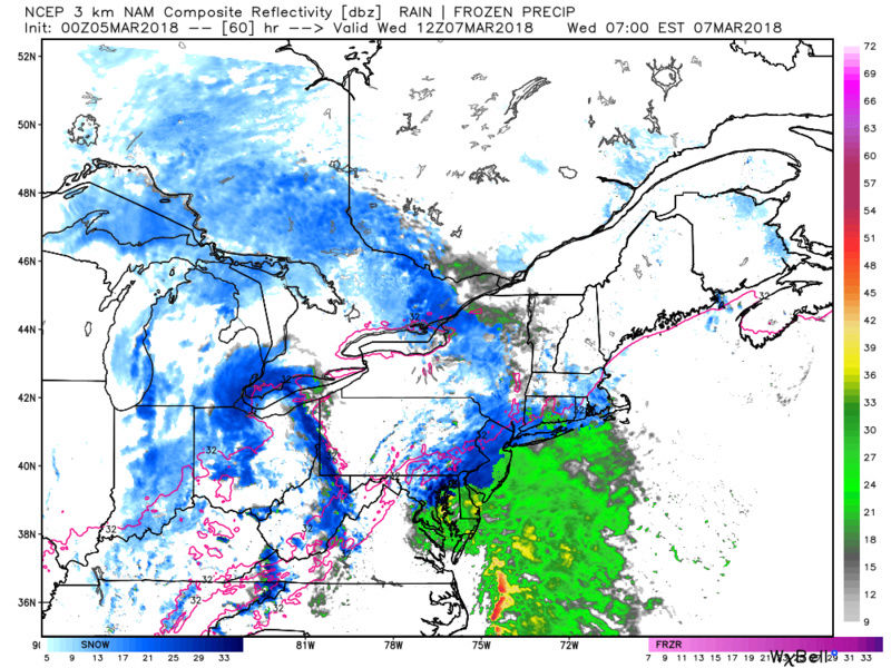
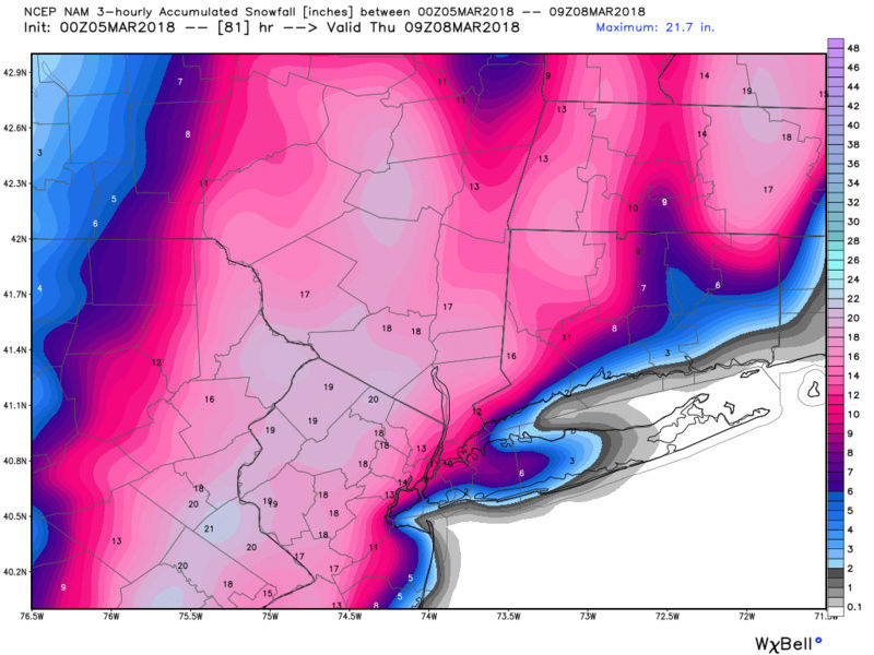
3km nam is kinda a bit different.

jmanley32- Senior Enthusiast

- Posts : 20535
Reputation : 108
Join date : 2013-12-12
Age : 43
Location : Yonkers, NY
 Re: March 7th-8th 2018 Storm Potential
jmanley32 wrote:3km nam is kinda a bit different.
If anything, 3k is more amped than the regular/12k were. H5 trough is deeper. This is literally insane. I am WIRED right now.
rb924119- Meteorologist

- Posts : 6928
Reputation : 194
Join date : 2013-02-06
Age : 32
Location : Greentown, Pa
 Re: March 7th-8th 2018 Storm Potential
Sweet jesus 3km nam!! Godzilla for all?! Snowing like crazy at 7am, def coming in earlier. Looks huge if extrapolated out.


jmanley32- Senior Enthusiast

- Posts : 20535
Reputation : 108
Join date : 2013-12-12
Age : 43
Location : Yonkers, NY
 Re: March 7th-8th 2018 Storm Potential
jmanley32 wrote:Sweet jesus 3km nam!! Godzilla for all?! Snowing like crazy at 7am, def coming in earlier. Looks huge if extrapolated out.
Like I said ahahaha best part of that is that the system hasn't even developed yet. Freakish.
rb924119- Meteorologist

- Posts : 6928
Reputation : 194
Join date : 2013-02-06
Age : 32
Location : Greentown, Pa
 Re: March 7th-8th 2018 Storm Potential
Roidzilla with "B" potential with more power outages? I got my wind storm not wishing it on anyone just curious if the winds are in the same favorable direction as Fri?rb924119 wrote:jmanley32 wrote:3km nam is kinda a bit different.
If anything, 3k is more amped than the regular/12k were. H5 trough is deeper. This is literally insane. I am WIRED right now.

jmanley32- Senior Enthusiast

- Posts : 20535
Reputation : 108
Join date : 2013-12-12
Age : 43
Location : Yonkers, NY
 Re: March 7th-8th 2018 Storm Potential
OMG...may have another nuclear bomb here, lets see what tomorrow brings, love it when we have storms to keep us occupied and then one only a short time after, not as agonizing a wait.rb924119 wrote:jmanley32 wrote:Sweet jesus 3km nam!! Godzilla for all?! Snowing like crazy at 7am, def coming in earlier. Looks huge if extrapolated out.
Like I said ahahaha best part of that is that the system hasn't even developed yet. Freakish.

jmanley32- Senior Enthusiast

- Posts : 20535
Reputation : 108
Join date : 2013-12-12
Age : 43
Location : Yonkers, NY
 Re: March 7th-8th 2018 Storm Potential
Bernie says he likes NYC on north for best potential for 6"+ and that includes coastal areas. However he mentioned it has to thump to accumulate this time of year. Also mentioned we will see the "windshield wiper" effect in full force with this storm. west/east shifts will occur through the next 24hrs.
_________________
-Alex Iannone-

aiannone- Senior Enthusiast - Mod

- Posts : 4815
Reputation : 92
Join date : 2013-01-07
Location : Saint James, LI (Northwest Suffolk Co.)
 Re: March 7th-8th 2018 Storm Potential
jmanley32 wrote:Roidzilla with "B" potential with more power outages? I got my wind storm not wishing it on anyone just curious if the winds are in the same favorable direction as Fri?rb924119 wrote:jmanley32 wrote:3km nam is kinda a bit different.
If anything, 3k is more amped than the regular/12k were. H5 trough is deeper. This is literally insane. I am WIRED right now.
Roidzilla possibly in isolated spots, but I think Godzilla overall. Roidzillas are tough to get, especially region-wide. Usually, it's about a 50-mile swath that ends up with totals that high in even the best storms. "B" potential? Maybe right along the I-95 corridor, but I don't think you'll see sustained windspeed that high. Power outages? How can you lose what you still don't have? lol I think whoever is still without power Tuesday afternoon is going to remain that way for a while, especially if this verified verbatim. More tree damage and road blockages which will prevent power companies from resuming their work right away after the storm ends. As for your final question, Jman; you tell me
rb924119- Meteorologist

- Posts : 6928
Reputation : 194
Join date : 2013-02-06
Age : 32
Location : Greentown, Pa
 Re: March 7th-8th 2018 Storm Potential
track17 wrote:Not gonna happen syo I am done with this storm drew me in but horrible set up for my area
Track give it a day....watch the Bernie rayon video said it would wind shield wiper

weatherwatchermom- Senior Enthusiast

- Posts : 3793
Reputation : 78
Join date : 2014-11-25
Location : Hazlet Township, NJ
 Re: March 7th-8th 2018 Storm Potential
track17 wrote:Again that is not the coastal areas this is a nj board not just ny
Correct, track. But he was just asking if they were possible given this solution. The general idea of snow totals is not going to be known for another 36-42 hours most likely, so everybody is still very much in this game, and that's what everybody has to understand. You're essentially getting a triple phase, and each phase adds multiple tiers of complexity to try and figure out, so basically this can still go anywhere. We just have to look and see if there are any clues in the modeling as to which way this is likely to go from here (i.e. keep trending west, remain status-quo, or start trending back east). That's all any of us can do. Admittedly, climatology favors the interior heavily for late-season events, like what we just saw. However, no two systems are alike. For now, we just have to remain patient and continue to analyze this as best we can. Nothing else we can do, or, should be worried about at this time.
rb924119- Meteorologist

- Posts : 6928
Reputation : 194
Join date : 2013-02-06
Age : 32
Location : Greentown, Pa
 Re: March 7th-8th 2018 Storm Potential
I am fine the only thing thta annoys me is when people only worry about ny area and assume that is for everyone and then quote Bernie who is an idiot
track17- Posts : 454
Reputation : 4
Join date : 2016-01-09
 Re: March 7th-8th 2018 Storm Potential
Quietace wrote:I would also keep a eye on your 850/700mb lows....they are fairly close to your guys area. Strength of warm air advection in the mid-levels could be tricky...
Excellent point.
jmanley32 wrote:So close to everyone seeing a godzilla, 10-12 for me rest of area sees 12-20, but al lits go take is a tiny job east.
Set-up is very favorable for a Godzilla
_________________
_______________________________________________________________________________________________________
CLICK HERE to view NJ Strong Snowstorm Classifications
 Re: March 7th-8th 2018 Storm Potential
I keep forgetting what you said but i think yes? Well I am right along the I-95 corridor so bring it on! Just for comparison, if you look at hr 60 of the 3km the gusts down right offshore of VA are 77 mph, and as you said this isnt even formed yet, kinda concerned for a lot of ppl I know, seems any wind issues will be more coastal this time as its nowhere near as huge. IF they do become a issue. Yeah Yonkers is set for Tuesday 11am per Coned, is that true? prolly not and ya if we get heavy wet snow on the already weakened trees with sokaed ground and this could potentially be worse, but I am going to be more focused on the snow as I got the major shaft Fri, def not on the wind though, even now from time to time I hear a gust outside.rb924119 wrote:jmanley32 wrote:Roidzilla with "B" potential with more power outages? I got my wind storm not wishing it on anyone just curious if the winds are in the same favorable direction as Fri?rb924119 wrote:jmanley32 wrote:3km nam is kinda a bit different.
If anything, 3k is more amped than the regular/12k were. H5 trough is deeper. This is literally insane. I am WIRED right now.
Roidzilla possibly in isolated spots, but I think Godzilla overall. Roidzillas are tough to get, especially region-wide. Usually, it's about a 50-mile swath that ends up with totals that high in even the best storms. "B" potential? Maybe right along the I-95 corridor, but I don't think you'll see sustained windspeed that high. Power outages? How can you lose what you still don't have? lol I think whoever is still without power Tuesday afternoon is going to remain that way for a while, especially if this verified verbatim. More tree damage and road blockages which will prevent power companies from resuming their work right away after the storm ends. As for your final question, Jman; you tell me

jmanley32- Senior Enthusiast

- Posts : 20535
Reputation : 108
Join date : 2013-12-12
Age : 43
Location : Yonkers, NY
rb924119- Meteorologist

- Posts : 6928
Reputation : 194
Join date : 2013-02-06
Age : 32
Location : Greentown, Pa
 Re: March 7th-8th 2018 Storm Potential
Glad to hear Frank, out of all the systems this year it seems your quite into this one. If your in I am in. No your map did not verify Fri, but it was crazy what was going on snow here and 1 mile away not there. No one could have predicted that. Heres to hoping we all get pasted : )Frank_Wx wrote:Quietace wrote:I would also keep a eye on your 850/700mb lows....they are fairly close to your guys area. Strength of warm air advection in the mid-levels could be tricky...
Excellent point.jmanley32 wrote:So close to everyone seeing a godzilla, 10-12 for me rest of area sees 12-20, but al lits go take is a tiny job east.
Set-up is very favorable for a Godzilla
rb, your very right only mother nature knows final outcome. We have to temper ourselves a bit albeit so hard lol, especially when you get into all caps lol

jmanley32- Senior Enthusiast

- Posts : 20535
Reputation : 108
Join date : 2013-12-12
Age : 43
Location : Yonkers, NY
 Re: March 7th-8th 2018 Storm Potential
Track, as currently modeled most of NJ will see heavy snow with some accumulation (caveat this could change in 48 hours of model shifts). Unfortunately, yes, the closer this ticks to the coast the greater chance that a small sliver of the state right by the shore may face mixing issues. But it’s entirely possible with a track just east of where it’s modeled now the snow predominates at the shore as well.

billg315- Advanced Forecaster - Mod

- Posts : 4483
Reputation : 185
Join date : 2015-01-24
Age : 50
Location : Flemington, NJ
 Re: March 7th-8th 2018 Storm Potential
As to issues with sticking, a lot of this snow comes before dawn so it may start sticking from the outset as it may be freezing at daybreak Wed. With this projected precip intensity and the storm underway by daybreak, and then continuing for several hours after sunset Wed., I am not nearly as worried about snow melting as I was last Friday (again remember the high last Thur was 62 and it was 41 Friday morning before the changeover. Temps Tuesday and Tue night will be MUCH colder. This is not last weeks storm.

billg315- Advanced Forecaster - Mod

- Posts : 4483
Reputation : 185
Join date : 2015-01-24
Age : 50
Location : Flemington, NJ
 Re: March 7th-8th 2018 Storm Potential
Track i was just trying to tell you we have to wait and see..and fyi I live on Jersey Coasttrack17 wrote:I am fine the only thing thta annoys me is when people only worry about ny area and assume that is for everyone and then quote Bernie who is an idiot

weatherwatchermom- Senior Enthusiast

- Posts : 3793
Reputation : 78
Join date : 2014-11-25
Location : Hazlet Township, NJ
 Re: March 7th-8th 2018 Storm Potential
Doesnt it only go out to hr 48? What what lol? Tell post images your such a teaserb924119 wrote:GOOD GOD THE RGEM

jmanley32- Senior Enthusiast

- Posts : 20535
Reputation : 108
Join date : 2013-12-12
Age : 43
Location : Yonkers, NY
 Re: March 7th-8th 2018 Storm Potential
rb924119 wrote:GOOD GOD THE RGEM
Image?
_________________
-Alex Iannone-

aiannone- Senior Enthusiast - Mod

- Posts : 4815
Reputation : 92
Join date : 2013-01-07
Location : Saint James, LI (Northwest Suffolk Co.)
Page 5 of 19 •  1, 2, 3, 4, 5, 6 ... 12 ... 19
Page 5 of 19
Permissions in this forum:
You cannot reply to topics in this forum|
|
|

 Home
Home
