
 Search
March 7th-8th 2018 Storm Potential
Page 17 of 19 •  1 ... 10 ... 16, 17, 18, 19
 ![]()
Re: March 7th-8th 2018 Storm Potential
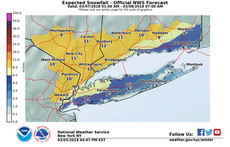
![]() by RJB8525 Mon Mar 05, 2018 3:56 pm
by RJB8525 Mon Mar 05, 2018 3:56 pm
Last edited by RJB8525 on Mon Mar 05, 2018 3:57 pm; edited 1 time in total
RJB8525- Senior Enthusiast

- Posts : 1994
Join date : 2013-02-06
Re: March 7th-8th 2018 Storm Potential
![]() by billg315 Mon Mar 05, 2018 3:57 pm
by billg315 Mon Mar 05, 2018 3:57 pm
National Weather Service Mount Holly NJ
340 PM EST Mon Mar 5 2018
...A major snowstorm is on the way for portions of our area on
Wednesday...
.Unfortunately, a major nor`easter will be intensifying rapidly
Wednesday afternoon along the New Jersey coast. It is expected to
produce heavy wet snow for eastern Pennsylvania and portions New
Jersey Wednesday. Highest amounts should be in the hilly areas.
While this storm is still in watch phase, we recommend everyone
with activities in eastern Pennsylvania and New Jersey to have
contingency plans for altering travel and how to handle possible
power related impacts. These plans can then be applied once
warnings are issued, which will express more confidence in this
oncoming probable very high impact event. Wednesday may be a good
day to just stay home and be safe.
NJZ001-007>010-PAZ054-055-060>062-103-105-061000-
/O.EXT.KPHI.WS.A.0005.180307T0000Z-180308T0800Z/
Sussex-Warren-Morris-Hunterdon-Somerset-Carbon-Monroe-Berks-
Lehigh-Northampton-Western Montgomery-Upper Bucks-
Including the cities of Newton, Washington, Morristown,
Flemington, Somerville, Jim Thorpe, Stroudsburg, Reading,
Allentown, Bethlehem, Easton, Collegeville, Pottstown, Chalfont,
and Perkasie
340 PM EST Mon Mar 5 2018
...WINTER STORM WATCH NOW IN EFFECT FROM TUESDAY EVENING THROUGH
LATE WEDNESDAY NIGHT...
* WHAT...Heavy snow possible. Total snow accumulations of 10 to 14
inches are possible, heaviest amounts in the higher elevations.
* WHERE...Portions of northern and northwest New Jersey and east
central, northeast and southeast Pennsylvania.
* WHEN...From Tuesday evening through late Wednesday night.
* ADDITIONAL DETAILS...Travel will probably be very difficult to
impossible, including during the evening commute on Wednesday.
Significant reductions in visibility are likely. Snow will
probably accumulate at a rate of 1 to 2 inches per hour for
several hours, especially during Wednesday afternoon and
evening. Power outages may develop from newly broken tree limbs
or from uprooted trees in the softened ground, especially where
6 inches or more accumulates on the branches. This could become
a dangerous situation and contingency plans should be developed
for altering activities as a high impact major snow storm is
expected Wednesday. If and when warnings are issued, those
contingency plans can be implemented. We recommend following the
advice of local officials and this may be a good day to just stay
home, to ensure safety.
billg315- Advanced Forecaster - Mod

- Posts : 4483
Join date : 2015-01-24
Re: March 7th-8th 2018 Storm Potential
![]() by mikeypizano Mon Mar 05, 2018 3:57 pm
by mikeypizano Mon Mar 05, 2018 3:57 pm

mikeypizano- Pro Enthusiast

- Posts : 1118
Reputation : 66
Join date : 2017-01-05
Age : 35
Location : Wilkes-Barre/Scranton, PA
Re: March 7th-8th 2018 Storm Potential
![]() by RJB8525 Mon Mar 05, 2018 3:59 pm
by RJB8525 Mon Mar 05, 2018 3:59 pm

RJB8525- Senior Enthusiast
- Posts : 1994
Reputation : 28
Join date : 2013-02-06
Age : 38
Location : Hackettstown, NJ
Re: March 7th-8th 2018 Storm Potential
![]() by jmanley32 Mon Mar 05, 2018 4:00 pm
by jmanley32 Mon Mar 05, 2018 4:00 pm
yep I knew power outages go b issues again. Where's Upton they should basically b same from central long islsnd west.billg315 wrote:URGENT - WINTER WEATHER MESSAGE
National Weather Service Mount Holly NJ
340 PM EST Mon Mar 5 2018
...A major snowstorm is on the way for portions of our area on
Wednesday...
.Unfortunately, a major nor`easter will be intensifying rapidly
Wednesday afternoon along the New Jersey coast. It is expected to
produce heavy wet snow for eastern Pennsylvania and portions New
Jersey Wednesday. Highest amounts should be in the hilly areas.
While this storm is still in watch phase, we recommend everyone
with activities in eastern Pennsylvania and New Jersey to have
contingency plans for altering travel and how to handle possible
power related impacts. These plans can then be applied once
warnings are issued, which will express more confidence in this
oncoming probable very high impact event. Wednesday may be a good
day to just stay home and be safe.
NJZ001-007>010-PAZ054-055-060>062-103-105-061000-
/O.EXT.KPHI.WS.A.0005.180307T0000Z-180308T0800Z/
Sussex-Warren-Morris-Hunterdon-Somerset-Carbon-Monroe-Berks-
Lehigh-Northampton-Western Montgomery-Upper Bucks-
Including the cities of Newton, Washington, Morristown,
Flemington, Somerville, Jim Thorpe, Stroudsburg, Reading,
Allentown, Bethlehem, Easton, Collegeville, Pottstown, Chalfont,
and Perkasie
340 PM EST Mon Mar 5 2018
...WINTER STORM WATCH NOW IN EFFECT FROM TUESDAY EVENING THROUGH
LATE WEDNESDAY NIGHT...
* WHAT...Heavy snow possible. Total snow accumulations of 10 to 14
inches are possible, heaviest amounts in the higher elevations.
* WHERE...Portions of northern and northwest New Jersey and east
central, northeast and southeast Pennsylvania.
* WHEN...From Tuesday evening through late Wednesday night.
* ADDITIONAL DETAILS...Travel will probably be very difficult to
impossible, including during the evening commute on Wednesday.
Significant reductions in visibility are likely. Snow will
probably accumulate at a rate of 1 to 2 inches per hour for
several hours, especially during Wednesday afternoon and
evening. Power outages may develop from newly broken tree limbs
or from uprooted trees in the softened ground, especially where
6 inches or more accumulates on the branches. This could become
a dangerous situation and contingency plans should be developed
for altering activities as a high impact major snow storm is
expected Wednesday. If and when warnings are issued, those
contingency plans can be implemented. We recommend following the
advice of local officials and this may be a good day to just stay
home, to ensure safety.

jmanley32- Senior Enthusiast
- Posts : 20535
Reputation : 108
Join date : 2013-12-12
Age : 43
Location : Yonkers, NY
jmanley32- Senior Enthusiast
- Posts : 20535
Reputation : 108
Join date : 2013-12-12
Age : 43
Location : Yonkers, NY
Re: March 7th-8th 2018 Storm Potential
![]() by mikeypizano Mon Mar 05, 2018 4:01 pm
by mikeypizano Mon Mar 05, 2018 4:01 pm
mikeypizano- Pro Enthusiast
- Posts : 1118
Reputation : 66
Join date : 2017-01-05
Age : 35
Location : Wilkes-Barre/Scranton, PA
Re: March 7th-8th 2018 Storm Potential
![]() by crippo84 Mon Mar 05, 2018 4:01 pm
by crippo84 Mon Mar 05, 2018 4:01 pm

crippo84- Posts : 383
Reputation : 20
Join date : 2013-11-07
Age : 40
Location : East Village, NYC
Re: March 7th-8th 2018 Storm Potential
![]() by Frank_Wx Mon Mar 05, 2018 4:01 pm
by Frank_Wx Mon Mar 05, 2018 4:01 pm
-Chat tonight at 8:45pm. Check the other pinned thread for more details. Note, that is an old thread from last year but the instructions are the same. I posted the link in the last post of that thread
-Blog and 1st call snow map sometime before chat starts
_________________
_______________________________________________________________________________________________________
CLICK HERE to view NJ Strong Snowstorm Classifications

Frank_Wx- Godzilla Seeker

- Posts : 21305
Reputation : 328
Join date : 2013-01-05
Age : 32
Location : Jersey City, NJ -

Re: March 7th-8th 2018 Storm Potential
![]() by RJB8525 Mon Mar 05, 2018 4:02 pm
by RJB8525 Mon Mar 05, 2018 4:02 pm
mikeypizano wrote:Hope it comes about 50 miles west...
you need to make good use out of that stocked fridge
RJB8525- Senior Enthusiast
- Posts : 1994
Reputation : 28
Join date : 2013-02-06
Age : 38
Location : Hackettstown, NJ
Re: March 7th-8th 2018 Storm Potential
![]() by jmanley32 Mon Mar 05, 2018 4:02 pm
by jmanley32 Mon Mar 05, 2018 4:02 pm
jmanley32- Senior Enthusiast
- Posts : 20535
Reputation : 108
Join date : 2013-12-12
Age : 43
Location : Yonkers, NY
Re: March 7th-8th 2018 Storm Potential
![]() by Frank_Wx Mon Mar 05, 2018 4:03 pm
by Frank_Wx Mon Mar 05, 2018 4:03 pm
crippo84 wrote:This is seeming more long duration than earlier modeled no? What timeframe are we looking at? Start early morning Wednesday and ending around or after midnight wednesday night / thursday morning?
1-2am Wednesday to 5-6pm Wesnesday
Fairly long but depends on whether or not the low pressure retrogrades or not
_________________
_______________________________________________________________________________________________________
CLICK HERE to view NJ Strong Snowstorm Classifications
Frank_Wx- Godzilla Seeker
- Posts : 21305
Reputation : 328
Join date : 2013-01-05
Age : 32
Location : Jersey City, NJ -
Re: March 7th-8th 2018 Storm Potential
![]() by mikeypizano Mon Mar 05, 2018 4:03 pm
by mikeypizano Mon Mar 05, 2018 4:03 pm
RJB8525 wrote:mikeypizano wrote:Hope it comes about 50 miles west...
you need to make good use out of that stocked fridge
I need money
mikeypizano- Pro Enthusiast
- Posts : 1118
Reputation : 66
Join date : 2017-01-05
Age : 35
Location : Wilkes-Barre/Scranton, PA
Re: March 7th-8th 2018 Storm Potential
![]() by jmanley32 Mon Mar 05, 2018 4:04 pm
by jmanley32 Mon Mar 05, 2018 4:04 pm
frank is 3km out to lunch or achievable?Frank_Wx wrote:-Godzilla mode activated. Thinking most places will come very close to 1 foot of snow.
-Chat tonight at 8:45pm. Check the other pinned thread for more details. Note, that is an old thread from last year but the instructions are the same. I posted the link in the last post of that thread
-Blog and 1st call snow map sometime before chat starts
jmanley32- Senior Enthusiast
- Posts : 20535
Reputation : 108
Join date : 2013-12-12
Age : 43
Location : Yonkers, NY
Re: March 7th-8th 2018 Storm Potential
![]() by jmanley32 Mon Mar 05, 2018 4:05 pm
by jmanley32 Mon Mar 05, 2018 4:05 pm
jmanley32- Senior Enthusiast
- Posts : 20535
Reputation : 108
Join date : 2013-12-12
Age : 43
Location : Yonkers, NY

adamfitz1969- Posts : 122
Reputation : 14
Join date : 2018-03-01
Age : 54
Location : Tarrytown
Re: March 7th-8th 2018 Storm Potential
![]() by amugs Mon Mar 05, 2018 4:13 pm
by amugs Mon Mar 05, 2018 4:13 pm

_________________
Mugs
AKA:King: Snow Weenie
Self Proclaimed
WINTER 2014-15 : 55.12" +.02 for 6 coatings (avg. 35")
WINTER 2015-16 Total - 29.8" (Avg 35")
WINTER 2016-17 : 39.5" so far

amugs- Advanced Forecaster - Mod
- Posts : 15095
Reputation : 213
Join date : 2013-01-07
Age : 54
Location : Hillsdale,NJ
Re: March 7th-8th 2018 Storm Potential
![]() by hurrysundown23 Mon Mar 05, 2018 4:16 pm
by hurrysundown23 Mon Mar 05, 2018 4:16 pm
Your Radar | Current Conditions | 15-Day Forecast
URGENT - WINTER WEATHER MESSAGE
National Weather Service Mount Holly NJ
340 PM EST Mon Mar 5 2018
...A major snowstorm is on the way for portions of our area on
Wednesday...
.Unfortunately, a major nor'easter will be intensifying rapidly
Wednesday afternoon along the New Jersey coast. It is expected to
produce heavy wet snow for eastern Pennsylvania and portions New
Jersey Wednesday. Highest amounts should be in the hilly areas.
While this storm is still in watch phase, we recommend everyone
with activities in eastern Pennsylvania and New Jersey to have
contingency plans for altering travel and how to handle possible
power related impacts. These plans can then be applied once
warnings are issued, which will express more confidence in this
oncoming probable very high impact event. Wednesday may be a good
day to just stay home and be safe.
...WINTER STORM WATCH IN EFFECT FROM TUESDAY EVENING THROUGH LATE
WEDNESDAY NIGHT...
* WHAT...Heavy snow possible. Total snow accumulations of 3 to 6
inches, with localized amounts up to 13 inches possible,
especially near and just west of the Interstate 95 corridor and
in the hilly areas of southeastern Pennsylvania and northeastern
New Jersey.
* WHERE...Portions of central, northern and southern New Jersey,
southeast Pennsylvania, northeast Maryland and northern
Delaware.
* WHEN...From Tuesday evening through late Wednesday night.
* ADDITIONAL DETAILS...Plan on difficult travel conditions at
times, including during both commutes on Wednesday. Significant
reductions in visibility are likely. Snow should begin Tuesday
night with slushy accumulations by dawn Wednesday. There may be
a brief change to rain during the early morning daylight hours
but precipitation should change back to snow by midday and all
heavily for several hours during midday and the afternoon with 1
inch per hour rates. Wind gusts to 45 MPH will be possible in
northeastern New Jersey. The snow will be wet and may result in
power outages. So while there is still uncertainty, strong
consideration should be given to contingency plans should a
warning be issued for snow amounts exceeding 5 inches.
PRECAUTIONARY/PREPAREDNESS ACTIONS...
A Winter Storm Watch means there is potential for significant
snow, sleet or ice accumulations that may impact travel. Continue
to monitor the latest forecasts.
hurrysundown23- Posts : 53
Reputation : 1
Join date : 2017-01-04
Location : Sayreville, NJ
Re: March 7th-8th 2018 Storm Potential
![]() by SoulSingMG Mon Mar 05, 2018 4:23 pm
by SoulSingMG Mon Mar 05, 2018 4:23 pm

SoulSingMG- Senior Enthusiast
- Posts : 2853
Reputation : 74
Join date : 2013-12-11
Location : Long Island City, NY
Re: March 7th-8th 2018 Storm Potential
![]() by WeatherBob Mon Mar 05, 2018 4:23 pm
by WeatherBob Mon Mar 05, 2018 4:23 pm

WeatherBob- Meteorologist

- Posts : 683
Reputation : 83
Join date : 2013-12-13
Location : Caldwell, NJ - NW Essex County - Altitude 500 FT

mikeypizano- Pro Enthusiast
- Posts : 1118
Reputation : 66
Join date : 2017-01-05
Age : 35
Location : Wilkes-Barre/Scranton, PA
Re: March 7th-8th 2018 Storm Potential
![]() by WeatherBob Mon Mar 05, 2018 4:28 pm
by WeatherBob Mon Mar 05, 2018 4:28 pm
WeatherBob- Meteorologist
- Posts : 683
Reputation : 83
Join date : 2013-12-13
Location : Caldwell, NJ - NW Essex County - Altitude 500 FT
Re: March 7th-8th 2018 Storm Potential
![]() by jmanley32 Mon Mar 05, 2018 4:29 pm
by jmanley32 Mon Mar 05, 2018 4:29 pm
jmanley32- Senior Enthusiast
- Posts : 20535
Reputation : 108
Join date : 2013-12-12
Age : 43
Location : Yonkers, NY
Re: March 7th-8th 2018 Storm Potential
![]() by jmanley32 Mon Mar 05, 2018 4:30 pm
by jmanley32 Mon Mar 05, 2018 4:30 pm
lol we literally posted the same time. Ominous how? Like they aren't ready to post the beast that is to come?WeatherBob wrote:Uptown not out with forecast discussion and it 4:30 pm. Very ominous!!!!!
jmanley32- Senior Enthusiast
- Posts : 20535
Reputation : 108
Join date : 2013-12-12
Age : 43
Location : Yonkers, NY
Re: March 7th-8th 2018 Storm Potential
![]() by aiannone Mon Mar 05, 2018 4:31 pm
by aiannone Mon Mar 05, 2018 4:31 pm
_________________
-Alex Iannone-

aiannone- Senior Enthusiast - Mod
- Posts : 4815
Reputation : 92
Join date : 2013-01-07
Location : Saint James, LI (Northwest Suffolk Co.)
Re: March 7th-8th 2018 Storm Potential
![]() by sroc4 Mon Mar 05, 2018 4:31 pm
by sroc4 Mon Mar 05, 2018 4:31 pm
Was thinking same thing. There are probably disagreements among forecasters since its the coast. I bet they are collaborating with other offices.WeatherBob wrote:Uptown not out with forecast discussion and it 4:30 pm. Very ominous!!!!!
_________________
"In weather and in life, there's no winning and losing; there's only winning and learning."
WINTER 2012/2013 TOTALS 43.65"WINTER 2017/2018 TOTALS 62.85" WINTER 2022/2023 TOTALS 4.9"
WINTER 2013/2014 TOTALS 64.85"WINTER 2018/2019 TOTALS 14.25" WINTER 2023/2024 TOTALS 13.1"
WINTER 2014/2015 TOTALS 71.20"WINTER 2019/2020 TOTALS 6.35"
WINTER 2015/2016 TOTALS 35.00"WINTER 2020/2021 TOTALS 37.75"
WINTER 2016/2017 TOTALS 42.25"WINTER 2021/2022 TOTALS 31.65"

sroc4- Admin
- Posts : 8354
Reputation : 302
Join date : 2013-01-07
Location : Wading River, LI


RJB8525- Senior Enthusiast
- Posts : 1994
Reputation : 28
Join date : 2013-02-06
Age : 38
Location : Hackettstown, NJ
Page 17 of 19 • 1 ... 10 ... 16, 17, 18, 19 ![]()
|
|
|