Tracking Another Possible Godzilla Mon-Tues, March 12th-13th
+39
mwilli5783
snowday111
devsman
aiannone
Taffy
Dunnzoo
gambri
Snow88
frank 638
Vinnydula
jimv45
SoulSingMG
WOLVES1
essexcountypete
crippo84
CPcantmeasuresnow
skinsfan1177
Smittyaj623
weatherwatchermom
Radz
Sanchize06
Math23x7
SNOW MAN
bobjohnsonforthehall
docstox12
rb924119
WeatherBob
Grselig
adamfitz1969
amugs
nutleyblizzard
RJB8525
oldtimer
billg315
jmanley32
sroc4
mikeypizano
jake732
Frank_Wx
43 posters
Page 1 of 17
Page 1 of 17 • 1, 2, 3 ... 9 ... 17 
 Tracking Another Possible Godzilla Mon-Tues, March 12th-13th
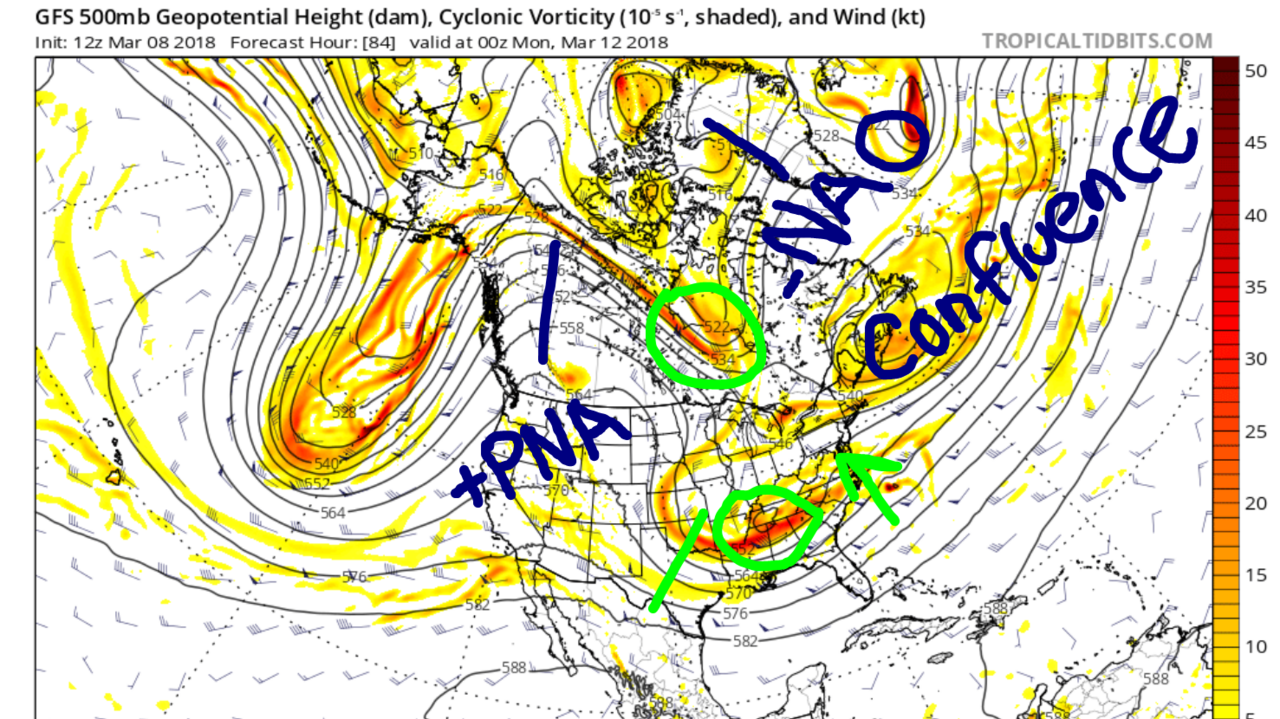
This is my interpretation of next week's storm based off 500mb valid late Sunday afternoon. The day before this potential storm would hit.
An anomalous North Pacific, or -WPO, ridge is going to send a cut-off low pressure over Alaska south into the eastern Pacific. This allows the U.S. west ridge to really amplify (+PNA). This low is not expected to crash into the west coast, thus allowing the +PNA ridge to remain intact. In fact, most models keep trending stronger with this ridge.
The -NAO over the Labrador Sea, or NW Atlantic, is not expected to weaken nor decay to a point where it has little impact. It is expected to stay anomalous and trap confluence beneath it. This confluence is leftover energy from yesterday's Godzilla - a closed 500mb low in southeastern Canada. This low forces low heights over New England and down the East Coast. Because the -NAO is not breaking down this closed low has nowhere to go but sit and spin for days in SE Canada.
Sub-tropical and Pacific 500mb energy is expected to enter the CONUS late Saturday. These pieces of energy, on the latest 12z GFS, phase to develop another powerful low pressure system. The +PNA is a main driver to why a phase happens in the first place. However, this low pressure system does not have much room to come north into our area. The confluence over New England (remember this is leftover energy from our Godzilla and the -NAO is keeping it stationary in SE Canada) keeps heights negative and the storm has no path to get here. Therefore, the trough stays positively tilted and EC heights remain flat because of spacing.
There is also - in what my eyes - is a "kicker" trough (green circle in south-central Canada). This trough feels the effects of the powerful +PNA and digs rapidly into the eastern U.S. So even if the low pressure system in the CONUS gets strong enough to raise heights on its own along the EC, we have to worry about this "kicker" "kicking" it too far east and out to sea.
On the contrary, some people may view the "kicker" as another piece of upper energy that could phase into the trough associated with the low pressure system. In theory this would be a triple-phase type of storm. However, that largely depends on the behavior and roles these upper vorts try to play. The polar energy could act as that third piece or it could act as the kicker. In my opinion, if it's too strong - basically a new trough - it will be the kicker we dread.
The best bet to seeing another Godzilla impact the area next week is to get the initial phase between the Sub-Tropical and Pacific jet energies, which I'm confident will happen, then have the storm generate positive heights along the EC and overcome the confluence on its own. Of course that runs the risk of temperatures being too warm for the immediate coast. So a triple phase with POLAR energy would show a very powerful / historic storm and likely not worry about warm temperatures. The pieces are there for that to happen but it depends on the role that polar energy decides to take.
All I'll say is a +PNA / -NAO combo can bring about special things. Do not be surprised to see some extreme model runs in the short-term. I am favoring a coastal storm at this time.
_________________
_______________________________________________________________________________________________________
CLICK HERE to view NJ Strong Snowstorm Classifications
 Re: Tracking Another Possible Godzilla Mon-Tues, March 12th-13th
GEFS and UKIE are well east with no impact for our area. I will pull the plug on this thread / system Sunday morning if it remains unlikely to happen. But keep in mind it is the type of set-up where models could show miss Saturday and hit Sunday.
_________________
_______________________________________________________________________________________________________
CLICK HERE to view NJ Strong Snowstorm Classifications
 Re: Tracking Another Possible Godzilla Mon-Tues, March 12th-13th
Thanx frank....Hope coastal sections do well
 Re: Tracking Another Possible Godzilla Mon-Tues, March 12th-13th
jake732 wrote:Thanx frank....Hope coastal sections do well
Keep it out of my area... I am D-O-N-E with snow...

mikeypizano- Pro Enthusiast

- Posts : 1118
Reputation : 66
Join date : 2017-01-05
Age : 35
Location : Wilkes-Barre/Scranton, PA
 Re: Tracking Another Possible Godzilla Mon-Tues, March 12th-13th
mikeypizano wrote:jake732 wrote:Thanx frank....Hope coastal sections do well
Keep it out of my area... I am D-O-N-E with snow...
not sure where u live but ill try to arrange to pass ur block
 Re: Tracking Another Possible Godzilla Mon-Tues, March 12th-13th
jake732 wrote:mikeypizano wrote:jake732 wrote:Thanx frank....Hope coastal sections do well
Keep it out of my area... I am D-O-N-E with snow...
not sure where u live but ill try to arrange to pass ur block
Wyoming Valley in NEPA. Keep he edge around Hazelton...

mikeypizano- Pro Enthusiast

- Posts : 1118
Reputation : 66
Join date : 2017-01-05
Age : 35
Location : Wilkes-Barre/Scranton, PA
 Re: Tracking Another Possible Godzilla Mon-Tues, March 12th-13th
Frank. Great write up:
There is also - in what my eyes - is a "kicker" trough (green circle in south-central Canada). This trough feels the effects of the powerful +PNA and digs rapidly into the eastern U.S. So even if the low pressure system in the CONUS gets strong enough to raise heights on its own along the EC, we have to worry about this "kicker" "kicking" it too far east and out to sea.
On the contrary, some people may view the "kicker" as another piece of upper energy that could phase into the trough associated with the low pressure system. In theory this would be a triple-phase type of storm. However, that largely depends on the behavior and roles these upper vorts try to play. The polar energy could act as that third piece or it could act as the kicker. In my opinion, if it's too strong - basically a new trough - it will be the kicker we dread.
This will be a VERY key component to where this system tracks. IF the N energy trends a little slow and the southern energy can get out ahead of it, and if we cont to see positive trends to the PNA ridge, then it could allow the Southern energy to raise heights out ahead creating the path north. And IF the N energy is timed right with said southern energy just out ahead and PNA does its dirty work and raises heights along the coast, it MAY dig into the back side of the developing southern energy and inject the system with cold air AND help tilt our trough complex neutral and neg. With the confluence established as you discussed, this really could be a doozy should things come together.
As it stands now in the majority of the modeling this N energy is either just out ahead, stays too far N, and or even with the southern energy. The result of this location is the N energy acts as the "kicker", or to steer/force the system to slide to our south.
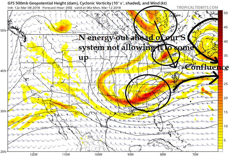
Again the key here is does the N energy act to steer or kick the system to our south, or does it act to enhance and help the system develop. Both scenarios are certainly viable. There are only subtle changes aloft that need to occur in order to change surface solns drastically. Keep that in mind Jon and others when looking at your surface maps from run to run. Even though it shows a miss the upper levels are nowhere near "slim to none" chances of happening.
There is also - in what my eyes - is a "kicker" trough (green circle in south-central Canada). This trough feels the effects of the powerful +PNA and digs rapidly into the eastern U.S. So even if the low pressure system in the CONUS gets strong enough to raise heights on its own along the EC, we have to worry about this "kicker" "kicking" it too far east and out to sea.
On the contrary, some people may view the "kicker" as another piece of upper energy that could phase into the trough associated with the low pressure system. In theory this would be a triple-phase type of storm. However, that largely depends on the behavior and roles these upper vorts try to play. The polar energy could act as that third piece or it could act as the kicker. In my opinion, if it's too strong - basically a new trough - it will be the kicker we dread.
This will be a VERY key component to where this system tracks. IF the N energy trends a little slow and the southern energy can get out ahead of it, and if we cont to see positive trends to the PNA ridge, then it could allow the Southern energy to raise heights out ahead creating the path north. And IF the N energy is timed right with said southern energy just out ahead and PNA does its dirty work and raises heights along the coast, it MAY dig into the back side of the developing southern energy and inject the system with cold air AND help tilt our trough complex neutral and neg. With the confluence established as you discussed, this really could be a doozy should things come together.
As it stands now in the majority of the modeling this N energy is either just out ahead, stays too far N, and or even with the southern energy. The result of this location is the N energy acts as the "kicker", or to steer/force the system to slide to our south.

Again the key here is does the N energy act to steer or kick the system to our south, or does it act to enhance and help the system develop. Both scenarios are certainly viable. There are only subtle changes aloft that need to occur in order to change surface solns drastically. Keep that in mind Jon and others when looking at your surface maps from run to run. Even though it shows a miss the upper levels are nowhere near "slim to none" chances of happening.
_________________
"In weather and in life, there's no winning and losing; there's only winning and learning."
WINTER 2012/2013 TOTALS 43.65"WINTER 2017/2018 TOTALS 62.85" WINTER 2022/2023 TOTALS 4.9"
WINTER 2013/2014 TOTALS 64.85"WINTER 2018/2019 TOTALS 14.25" WINTER 2023/2024 TOTALS 13.1"
WINTER 2014/2015 TOTALS 71.20"WINTER 2019/2020 TOTALS 6.35"
WINTER 2015/2016 TOTALS 35.00"WINTER 2020/2021 TOTALS 37.75"
WINTER 2016/2017 TOTALS 42.25"WINTER 2021/2022 TOTALS 31.65"

sroc4- Admin

- Posts : 8354
Reputation : 302
Join date : 2013-01-07
Location : Wading River, LI
 Re: Tracking Another Possible Godzilla Mon-Tues, March 12th-13th
CMC Ensembles!!!


_________________
_______________________________________________________________________________________________________
CLICK HERE to view NJ Strong Snowstorm Classifications
 Re: Tracking Another Possible Godzilla Mon-Tues, March 12th-13th
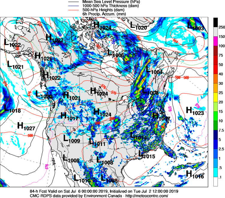
LR RGEM!!!!

_________________
_______________________________________________________________________________________________________
CLICK HERE to view NJ Strong Snowstorm Classifications
 Re: Tracking Another Possible Godzilla Mon-Tues, March 12th-13th

_________________
_______________________________________________________________________________________________________
CLICK HERE to view NJ Strong Snowstorm Classifications
 Re: Tracking Another Possible Godzilla Mon-Tues, March 12th-13th
Frank_Wx wrote:GEFS and UKIE are well east with no impact for our area. I will pull the plug on this thread / system Sunday morning if it remains unlikely to happen. But keep in mind it is the type of set-up where models could show miss Saturday and hit Sunday.
Pull it now Frank, let it die...

mikeypizano- Pro Enthusiast

- Posts : 1118
Reputation : 66
Join date : 2017-01-05
Age : 35
Location : Wilkes-Barre/Scranton, PA
 Re: Tracking Another Possible Godzilla Mon-Tues, March 12th-13th
Euro was a huge swing and miss to the south. Furthest south soln so far. With a spike in the PNA and the -NAO weakening I wouldn't write this off at all until Sunday.
_________________
"In weather and in life, there's no winning and losing; there's only winning and learning."
WINTER 2012/2013 TOTALS 43.65"WINTER 2017/2018 TOTALS 62.85" WINTER 2022/2023 TOTALS 4.9"
WINTER 2013/2014 TOTALS 64.85"WINTER 2018/2019 TOTALS 14.25" WINTER 2023/2024 TOTALS 13.1"
WINTER 2014/2015 TOTALS 71.20"WINTER 2019/2020 TOTALS 6.35"
WINTER 2015/2016 TOTALS 35.00"WINTER 2020/2021 TOTALS 37.75"
WINTER 2016/2017 TOTALS 42.25"WINTER 2021/2022 TOTALS 31.65"

sroc4- Admin

- Posts : 8354
Reputation : 302
Join date : 2013-01-07
Location : Wading River, LI
 Re: Tracking Another Possible Godzilla Mon-Tues, March 12th-13th
So is this a Godzilla potential or a roidzilla potential? I'm guessing if the latter part frank talked about and sroc highlighted happened that would be our roidzilla potential? Man u guys are chew away at calling me out sheesh. I am not go get sucked into look at every run verbatim if I comment it's only cuz I wanted see consistency but unless its 24 to 48 hrs or less away, a miss to me no longer means shut the door. Frank what if u shut the door sun morning and it surprises us like boxing day? Anyways great write up seems like a very complex setup to be able to happen and the slim to none comment came from another fb group which I dunno why I even look cuz u guys almost always get things right.

jmanley32- Senior Enthusiast

- Posts : 20535
Reputation : 108
Join date : 2013-12-12
Age : 43
Location : Yonkers, NY
 Re: Tracking Another Possible Godzilla Mon-Tues, March 12th-13th
this is lr rgem too or cmc ensembles? Some doozies in there they all are close to cape cod the ones that are hits we would want it south of there yes?Frank_Wx wrote:

jmanley32- Senior Enthusiast

- Posts : 20535
Reputation : 108
Join date : 2013-12-12
Age : 43
Location : Yonkers, NY
 Re: Tracking Another Possible Godzilla Mon-Tues, March 12th-13th
Frank are u just excited to see at least one model have it such as cmc ensembles or do u think cmc has merit cuz yesterday's storm I don't think we paid the cmc any mind. In fact some said it's been useless.

jmanley32- Senior Enthusiast

- Posts : 20535
Reputation : 108
Join date : 2013-12-12
Age : 43
Location : Yonkers, NY
 Re: Tracking Another Possible Godzilla Mon-Tues, March 12th-13th
I’ll take GEM 0.

billg315- Advanced Forecaster - Mod

- Posts : 4483
Reputation : 185
Join date : 2015-01-24
Age : 50
Location : Flemington, NJ
 Re: Tracking Another Possible Godzilla Mon-Tues, March 12th-13th
jmanley32 wrote:So is this a Godzilla potential or a roidzilla potential? I'm guessing if the latter part frank talked about and sroc highlighted happened that would be our roidzilla potential? Man u guys are chew away at calling me out sheesh. I am not go get sucked into look at every run verbatim if I comment it's only cuz I wanted see consistency but unless its 24 to 48 hrs or less away, a miss to me no longer means shut the door. Frank what if u shut the door sun morning and it surprises us like boxing day? Anyways great write up seems like a very complex setup to be able to happen and the slim to none comment came from another fb group which I dunno why I even look cuz u guys almost always get things right.
If 12z runs do not show this Sunday it is likely a goner.
jmanley32 wrote:this is lr rgem too or cmc ensembles? Some doozies in there they all are close to cape cod the ones that are hits we would want it south of there yes?Frank_Wx wrote:
This would phase and come north
jmanley32 wrote:Frank are u just excited to see at least one model have it such as cmc ensembles or do u think cmc has merit cuz yesterday's storm I don't think we paid the cmc any mind. In fact some said it's been useless.
RGEM/Canadian were one of the few models showing the 15"+ snow totals into western NJ and SNY. Anyway, I rather see the GEFS or EPS come on board.
_________________
_______________________________________________________________________________________________________
CLICK HERE to view NJ Strong Snowstorm Classifications
 Re: Tracking Another Possible Godzilla Mon-Tues, March 12th-13th
ya no kidding!billg315 wrote:I’ll take GEM 0.

jmanley32- Senior Enthusiast

- Posts : 20535
Reputation : 108
Join date : 2013-12-12
Age : 43
Location : Yonkers, NY
 Re: Tracking Another Possible Godzilla Mon-Tues, March 12th-13th
Lol. Not to be greedy or anything. I like the cut of its jib.jmanley32 wrote:ya no kidding!billg315 wrote:I’ll take GEM 0.

billg315- Advanced Forecaster - Mod

- Posts : 4483
Reputation : 185
Join date : 2015-01-24
Age : 50
Location : Flemington, NJ
 Re: Tracking Another Possible Godzilla Mon-Tues, March 12th-13th

_________________
_______________________________________________________________________________________________________
CLICK HERE to view NJ Strong Snowstorm Classifications
 Re: Tracking Another Possible Godzilla Mon-Tues, March 12th-13th
GEPS


_________________
_______________________________________________________________________________________________________
CLICK HERE to view NJ Strong Snowstorm Classifications
 Re: Tracking Another Possible Godzilla Mon-Tues, March 12th-13th
wow that's pretty good at this pt I'd say. Would u consider that at least a start to coming on board?Frank_Wx wrote:GEPS
Last edited by jmanley32 on Thu Mar 08, 2018 3:44 pm; edited 1 time in total

jmanley32- Senior Enthusiast

- Posts : 20535
Reputation : 108
Join date : 2013-12-12
Age : 43
Location : Yonkers, NY
 Re: Tracking Another Possible Godzilla Mon-Tues, March 12th-13th
Good or OK Frank
oldtimer- Senior Enthusiast

- Posts : 1103
Reputation : 14
Join date : 2013-01-16
Age : 78
Location : Port Jefferson Station Suffolk County
 Re: Tracking Another Possible Godzilla Mon-Tues, March 12th-13th
is the GEPS worth anything?

RJB8525- Senior Enthusiast

- Posts : 1994
Reputation : 28
Join date : 2013-02-06
Age : 38
Location : Hackettstown, NJ
 Re: Tracking Another Possible Godzilla Mon-Tues, March 12th-13th
RJB8525 wrote:is the GEPS worth anything?
About as much as your opinion Richard...
Just kidding, I know nothing about it.
I wanted to ask when will this system be properly sampled?

mikeypizano- Pro Enthusiast

- Posts : 1118
Reputation : 66
Join date : 2017-01-05
Age : 35
Location : Wilkes-Barre/Scranton, PA
Page 1 of 17 • 1, 2, 3 ... 9 ... 17 
Page 1 of 17
Permissions in this forum:
You cannot reply to topics in this forum
 Home
Home