
 Search
2018 Hurricane Season
Page 6 of 18 •  1 ... 5, 6, 7 ... 12 ... 18
 ![]()
Re: 2018 Hurricane Season
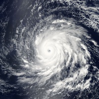
![]() by nutleyblizzard Wed Sep 05, 2018 12:18 pm
by nutleyblizzard Wed Sep 05, 2018 12:18 pm
nutleyblizzard- Senior Enthusiast

- Posts : 1954
Join date : 2014-01-30
Re: 2018 Hurricane Season
![]() by jmanley32 Wed Sep 05, 2018 2:30 pm
by jmanley32 Wed Sep 05, 2018 2:30 pm
Yep its go be a nail biter to have a 920mb hurricane headed to the coast not knowing exactly when and if it will turn. Euro looks like its going to do similar. Oh and gf s has the next one coming up the coast too. Lol gfs oh younutleyblizzard wrote:Watching the 12z GFS play out. The first trough missed and the ridge is building in. Nothing to stop Florence from making at least a glancing blow to the east coast.
jmanley32- Senior Enthusiast
- Posts : 20535
Join date : 2013-12-12
Re: 2018 Hurricane Season
![]() by jmanley32 Wed Sep 05, 2018 2:33 pm
by jmanley32 Wed Sep 05, 2018 2:33 pm

jmanley32- Senior Enthusiast
- Posts : 20535
Reputation : 108
Join date : 2013-12-12
Age : 43
Location : Yonkers, NY
Re: 2018 Hurricane Season
![]() by nutleyblizzard Wed Sep 05, 2018 2:45 pm
by nutleyblizzard Wed Sep 05, 2018 2:45 pm
Last edited by nutleyblizzard on Wed Sep 05, 2018 2:53 pm; edited 1 time in total

nutleyblizzard- Senior Enthusiast
- Posts : 1954
Reputation : 41
Join date : 2014-01-30
Age : 58
Location : Nutley, new jersey
Re: 2018 Hurricane Season
![]() by Frank_Wx Wed Sep 05, 2018 2:53 pm
by Frank_Wx Wed Sep 05, 2018 2:53 pm

_________________
_______________________________________________________________________________________________________
CLICK HERE to view NJ Strong Snowstorm Classifications

Frank_Wx- Godzilla Seeker

- Posts : 21305
Reputation : 328
Join date : 2013-01-05
Age : 32
Location : Jersey City, NJ -

Re: 2018 Hurricane Season
![]() by sroc4 Wed Sep 05, 2018 3:13 pm
by sroc4 Wed Sep 05, 2018 3:13 pm
Frank_Wx wrote:12z EURO is madonne...
Nothing like a little Cat4/5 action around the EC to bring out a madonne.
_________________
"In weather and in life, there's no winning and losing; there's only winning and learning."
WINTER 2012/2013 TOTALS 43.65"WINTER 2017/2018 TOTALS 62.85" WINTER 2022/2023 TOTALS 4.9"
WINTER 2013/2014 TOTALS 64.85"WINTER 2018/2019 TOTALS 14.25" WINTER 2023/2024 TOTALS 13.1"
WINTER 2014/2015 TOTALS 71.20"WINTER 2019/2020 TOTALS 6.35"
WINTER 2015/2016 TOTALS 35.00"WINTER 2020/2021 TOTALS 37.75"
WINTER 2016/2017 TOTALS 42.25"WINTER 2021/2022 TOTALS 31.65"

sroc4- Admin
- Posts : 8354
Reputation : 302
Join date : 2013-01-07
Location : Wading River, LI
Re: 2018 Hurricane Season
![]() by jmanley32 Wed Sep 05, 2018 3:21 pm
by jmanley32 Wed Sep 05, 2018 3:21 pm
jmanley32- Senior Enthusiast
- Posts : 20535
Reputation : 108
Join date : 2013-12-12
Age : 43
Location : Yonkers, NY
Re: 2018 Hurricane Season
![]() by jmanley32 Wed Sep 05, 2018 3:24 pm
by jmanley32 Wed Sep 05, 2018 3:24 pm
a madonne from frank 8 days out...do u still stand by a likely its? Or are u thinking it may b possible and if so when might u decide to take things seriously. One of my coworkers already asked me did I hear hurricane thurs Fri next week. So obviously there's talk of it in media already ugh.Frank_Wx wrote:12z EURO is madonne...
jmanley32- Senior Enthusiast
- Posts : 20535
Reputation : 108
Join date : 2013-12-12
Age : 43
Location : Yonkers, NY
Re: 2018 Hurricane Season
![]() by SoulSingMG Wed Sep 05, 2018 3:26 pm
by SoulSingMG Wed Sep 05, 2018 3:26 pm

...and of course WX Twitter just lost their gd minds.

SoulSingMG- Senior Enthusiast
- Posts : 2853
Reputation : 74
Join date : 2013-12-11
Location : Long Island City, NY
Re: 2018 Hurricane Season
![]() by Joe Snow Wed Sep 05, 2018 3:40 pm
by Joe Snow Wed Sep 05, 2018 3:40 pm
Frank_Wx wrote:12z EURO is madonne...
Well this will leave a mark, wow!

Joe Snow- Pro Enthusiast

- Posts : 924
Reputation : 7
Join date : 2014-02-12
Age : 62
Location : Sanford Florida, Fmrly Kings Park, NY
Re: 2018 Hurricane Season
![]() by nutleyblizzard Wed Sep 05, 2018 3:42 pm
by nutleyblizzard Wed Sep 05, 2018 3:42 pm
nutleyblizzard- Senior Enthusiast
- Posts : 1954
Reputation : 41
Join date : 2014-01-30
Age : 58
Location : Nutley, new jersey
Re: 2018 Hurricane Season
![]() by jmanley32 Wed Sep 05, 2018 3:50 pm
by jmanley32 Wed Sep 05, 2018 3:50 pm
yep well at least it won't be a surprise to people if she does make it across.SoulSingMG wrote:Holy Euro
...and of course WX Twitter just lost their gd minds.
jmanley32- Senior Enthusiast
- Posts : 20535
Reputation : 108
Join date : 2013-12-12
Age : 43
Location : Yonkers, NY
Re: 2018 Hurricane Season
![]() by jmanley32 Wed Sep 05, 2018 3:52 pm
by jmanley32 Wed Sep 05, 2018 3:52 pm
jmanley32- Senior Enthusiast
- Posts : 20535
Reputation : 108
Join date : 2013-12-12
Age : 43
Location : Yonkers, NY
Re: 2018 Hurricane Season
![]() by jmanley32 Wed Sep 05, 2018 4:08 pm
by jmanley32 Wed Sep 05, 2018 4:08 pm
CAT 4 status 130mph winds even NHC didnt see this coming, note how much further south/west the cone is than it was initially days ago (and if thats the position on sun/mon when the system was supposed to be pulled out, it looks way to far south to be influenced.) Plus only one H in there and I doubt she drops to a cat 2 at all. Interesting days coming!

jmanley32- Senior Enthusiast
- Posts : 20535
Reputation : 108
Join date : 2013-12-12
Age : 43
Location : Yonkers, NY
Re: 2018 Hurricane Season
![]() by jmanley32 Wed Sep 05, 2018 5:27 pm
by jmanley32 Wed Sep 05, 2018 5:27 pm

jmanley32- Senior Enthusiast
- Posts : 20535
Reputation : 108
Join date : 2013-12-12
Age : 43
Location : Yonkers, NY

jwalsh- Posts : 60
Reputation : 0
Join date : 2016-01-18
Location : Commack, NY
Re: 2018 Hurricane Season
![]() by jmanley32 Wed Sep 05, 2018 5:50 pm
by jmanley32 Wed Sep 05, 2018 5:50 pm
jmanley32- Senior Enthusiast
- Posts : 20535
Reputation : 108
Join date : 2013-12-12
Age : 43
Location : Yonkers, NY
Re: 2018 Hurricane Season
![]() by amugs Wed Sep 05, 2018 6:26 pm
by amugs Wed Sep 05, 2018 6:26 pm
She is quite compact and is foretasted to run into shear but that might not have as much as effect on her as we have sen her ability to ramp up. Maybe it will dissipate her, weaken her so she slides under the block and then gets pushed into teh coast.
Time will tell but it is a concern for the coast to watch this.
Lots of time here.
A few more days to see what happens with this whole pattern evolution. When was the last time an AEW made the trek across the Atlantic and slammed the EC as a major hcane? 1903? 1821?

Okay low solar for the 6 days, typhoons in the PAC pumping all this way or vapor and the warm anomalous waters in the Hotlantic pumping the Ridge coming about.
We'll see.
_________________
Mugs
AKA:King: Snow Weenie
Self Proclaimed
WINTER 2014-15 : 55.12" +.02 for 6 coatings (avg. 35")
WINTER 2015-16 Total - 29.8" (Avg 35")
WINTER 2016-17 : 39.5" so far

amugs- Advanced Forecaster - Mod

- Posts : 15095
Reputation : 213
Join date : 2013-01-07
Age : 54
Location : Hillsdale,NJ
Re: 2018 Hurricane Season
![]() by weatherwatchermom Wed Sep 05, 2018 6:26 pm
by weatherwatchermom Wed Sep 05, 2018 6:26 pm
and she has not hit the really warm waters yet, am I correct?jmanley32 wrote:She's a true buzzsaw. Monster prolly only go get stronger.

weatherwatchermom- Senior Enthusiast
- Posts : 3793
Reputation : 78
Join date : 2014-11-25
Location : Hazlet Township, NJ
Re: 2018 Hurricane Season
![]() by Snow88 Wed Sep 05, 2018 6:30 pm
by Snow88 Wed Sep 05, 2018 6:30 pm
GFS is about to go boom

Snow88- Senior Enthusiast
- Posts : 2193
Reputation : 4
Join date : 2013-01-09
Age : 35
Location : Brooklyn, NY
Snow88- Senior Enthusiast
- Posts : 2193
Reputation : 4
Join date : 2013-01-09
Age : 35
Location : Brooklyn, NY
Re: 2018 Hurricane Season
![]() by sroc4 Wed Sep 05, 2018 6:38 pm
by sroc4 Wed Sep 05, 2018 6:38 pm
Still a long way to go with this one.
_________________
"In weather and in life, there's no winning and losing; there's only winning and learning."
WINTER 2012/2013 TOTALS 43.65"WINTER 2017/2018 TOTALS 62.85" WINTER 2022/2023 TOTALS 4.9"
WINTER 2013/2014 TOTALS 64.85"WINTER 2018/2019 TOTALS 14.25" WINTER 2023/2024 TOTALS 13.1"
WINTER 2014/2015 TOTALS 71.20"WINTER 2019/2020 TOTALS 6.35"
WINTER 2015/2016 TOTALS 35.00"WINTER 2020/2021 TOTALS 37.75"
WINTER 2016/2017 TOTALS 42.25"WINTER 2021/2022 TOTALS 31.65"
sroc4- Admin
- Posts : 8354
Reputation : 302
Join date : 2013-01-07
Location : Wading River, LI
Re: 2018 Hurricane Season
![]() by jmanley32 Wed Sep 05, 2018 6:55 pm
by jmanley32 Wed Sep 05, 2018 6:55 pm
I dunno what to say at gf s...a cat 5 up Chesapeake....I can't even imagine and even with my obsession with canes and wind is be scared shitless. Highest wind I've ever experienced was prolly 100mph in bob and those were gusts.sroc4 wrote:18z GFS is pretty much the worst case scenario for this storm from Cape Hatt Through NE.
Still a long way to go with this one.
jmanley32- Senior Enthusiast
- Posts : 20535
Reputation : 108
Join date : 2013-12-12
Age : 43
Location : Yonkers, NY
Re: 2018 Hurricane Season
![]() by amugs Wed Sep 05, 2018 9:30 pm
by amugs Wed Sep 05, 2018 9:30 pm
Just adding my "2cents" to the discussion from observations as of late. Typically, we tend to look upstream for winter in regards to tracking, so why not apply that methodology here.... The 18z GFS pretty much represents the consensus of NWP (have checked CMC, GEFS, EPS). Two main areas I've been watching; 1. British Canada and 2. Midwest (Gorden remnants/ S/W troff). Notice initially right at the beginning of the loop how the trough off BC begins closer to the 150W meridian, and towards the latter end of the loop ends up towards 120W. Also take note of the orientation of the trough axis, and how it goes from a meridional look to one that is more positively tilted yielding a semi-zonal flow . This has a downstream effect because whereas runs dating back to Sept 1st or so, we saw a more retrograded type look of the ridge further back west where you have a weak steering flow, and thanks to the Coriolis effect, Florence can find that weakness pocket. However, because of this noticeable trend (?), we're seeing a "push" of everything eastward, including diabetic processes from the remnants of Gordon embedded within a shortwave trough, that influences that anomalous ridge over the NW Atlantic. In turn, we thus see rather strong ageostrophic confluence (highlighted in yellow) on the backside of the long wave trough and it reflects an impressive ~1030-1034mb surface high that can ultimately traverse quickly enough to mitigate that weakness area and critical inflection point. What I suppose I'm trying to convey is that via synoptic pattern wise, the trends aren't good meaning this threat has "legs
_________________
Mugs
AKA:King: Snow Weenie
Self Proclaimed
WINTER 2014-15 : 55.12" +.02 for 6 coatings (avg. 35")
WINTER 2015-16 Total - 29.8" (Avg 35")
WINTER 2016-17 : 39.5" so far
amugs- Advanced Forecaster - Mod
- Posts : 15095
Reputation : 213
Join date : 2013-01-07
Age : 54
Location : Hillsdale,NJ
Re: 2018 Hurricane Season
![]() by jmanley32 Wed Sep 05, 2018 10:11 pm
by jmanley32 Wed Sep 05, 2018 10:11 pm
Oh boy, I know you listen to this guy, most of you all so heads up I guess.amugs wrote:Our own Armando Salvatore posted on another board and if he leaning then we watch
Just adding my "2cents" to the discussion from observations as of late. Typically, we tend to look upstream for winter in regards to tracking, so why not apply that methodology here.... The 18z GFS pretty much represents the consensus of NWP (have checked CMC, GEFS, EPS). Two main areas I've been watching; 1. British Canada and 2. Midwest (Gorden remnants/ S/W troff). Notice initially right at the beginning of the loop how the trough off BC begins closer to the 150W meridian, and towards the latter end of the loop ends up towards 120W. Also take note of the orientation of the trough axis, and how it goes from a meridional look to one that is more positively tilted yielding a semi-zonal flow . This has a downstream effect because whereas runs dating back to Sept 1st or so, we saw a more retrograded type look of the ridge further back west where you have a weak steering flow, and thanks to the Coriolis effect, Florence can find that weakness pocket. However, because of this noticeable trend (?), we're seeing a "push" of everything eastward, including diabetic processes from the remnants of Gordon embedded within a shortwave trough, that influences that anomalous ridge over the NW Atlantic. In turn, we thus see rather strong ageostrophic confluence (highlighted in yellow) on the backside of the long wave trough and it reflects an impressive ~1030-1034mb surface high that can ultimately traverse quickly enough to mitigate that weakness area and critical inflection point. What I suppose I'm trying to convey is that via synoptic pattern wise, the trends aren't good meaning this threat has "legs
jmanley32- Senior Enthusiast
- Posts : 20535
Reputation : 108
Join date : 2013-12-12
Age : 43
Location : Yonkers, NY
Re: 2018 Hurricane Season
![]() by Joe Snow Wed Sep 05, 2018 10:37 pm
by Joe Snow Wed Sep 05, 2018 10:37 pm
jmanley32 wrote:Oh boy, I know you listen to this guy, most of you all so heads up I guess.amugs wrote:Our own Armando Salvatore posted on another board and if he leaning then we watch
Just adding my "2cents" to the discussion from observations as of late. Typically, we tend to look upstream for winter in regards to tracking, so why not apply that methodology here.... The 18z GFS pretty much represents the consensus of NWP (have checked CMC, GEFS, EPS). Two main areas I've been watching; 1. British Canada and 2. Midwest (Gorden remnants/ S/W troff). Notice initially right at the beginning of the loop how the trough off BC begins closer to the 150W meridian, and towards the latter end of the loop ends up towards 120W. Also take note of the orientation of the trough axis, and how it goes from a meridional look to one that is more positively tilted yielding a semi-zonal flow . This has a downstream effect because whereas runs dating back to Sept 1st or so, we saw a more retrograded type look of the ridge further back west where you have a weak steering flow, and thanks to the Coriolis effect, Florence can find that weakness pocket. However, because of this noticeable trend (?), we're seeing a "push" of everything eastward, including diabetic processes from the remnants of Gordon embedded within a shortwave trough, that influences that anomalous ridge over the NW Atlantic. In turn, we thus see rather strong ageostrophic confluence (highlighted in yellow) on the backside of the long wave trough and it reflects an impressive ~1030-1034mb surface high that can ultimately traverse quickly enough to mitigate that weakness area and critical inflection point. What I suppose I'm trying to convey is that via synoptic pattern wise, the trends aren't good meaning this threat has "legs
J Man Gonna be some long days ahead tracking.....................
Joe Snow- Pro Enthusiast
- Posts : 924
Reputation : 7
Join date : 2014-02-12
Age : 62
Location : Sanford Florida, Fmrly Kings Park, NY
Re: 2018 Hurricane Season
![]() by jmanley32 Wed Sep 05, 2018 10:44 pm
by jmanley32 Wed Sep 05, 2018 10:44 pm
for sure getting my rest now show starts or ends Sunday Monday I think. What have people been say on storm2k?Joe Snow wrote:jmanley32 wrote:Oh boy, I know you listen to this guy, most of you all so heads up I guess.amugs wrote:Our own Armando Salvatore posted on another board and if he leaning then we watch
Just adding my "2cents" to the discussion from observations as of late. Typically, we tend to look upstream for winter in regards to tracking, so why not apply that methodology here.... The 18z GFS pretty much represents the consensus of NWP (have checked CMC, GEFS, EPS). Two main areas I've been watching; 1. British Canada and 2. Midwest (Gorden remnants/ S/W troff). Notice initially right at the beginning of the loop how the trough off BC begins closer to the 150W meridian, and towards the latter end of the loop ends up towards 120W. Also take note of the orientation of the trough axis, and how it goes from a meridional look to one that is more positively tilted yielding a semi-zonal flow . This has a downstream effect because whereas runs dating back to Sept 1st or so, we saw a more retrograded type look of the ridge further back west where you have a weak steering flow, and thanks to the Coriolis effect, Florence can find that weakness pocket. However, because of this noticeable trend (?), we're seeing a "push" of everything eastward, including diabetic processes from the remnants of Gordon embedded within a shortwave trough, that influences that anomalous ridge over the NW Atlantic. In turn, we thus see rather strong ageostrophic confluence (highlighted in yellow) on the backside of the long wave trough and it reflects an impressive ~1030-1034mb surface high that can ultimately traverse quickly enough to mitigate that weakness area and critical inflection point. What I suppose I'm trying to convey is that via synoptic pattern wise, the trends aren't good meaning this threat has "legs
J Man Gonna be some long days ahead tracking.....................
jmanley32- Senior Enthusiast
- Posts : 20535
Reputation : 108
Join date : 2013-12-12
Age : 43
Location : Yonkers, NY
Page 6 of 18 • 1 ... 5, 6, 7 ... 12 ... 18 ![]()
|
|
|