Long Range Thread 17.0
+40
Radz
lglickman1
Wheezer
aiannone
heehaw453
SENJsnowman
Scullybutcher
jake732
Sanchize06
larryrock72
bobjohnsonforthehall
SnowForest
hyde345
SoulSingMG
weatherwatchermom
MattyICE
GreyBeard
Smittyaj623
HectorO
Vinnydula
Nyi1058
jmanley32
CPcantmeasuresnow
Dunnzoo
algae888
skinsfan1177
Snow88
Quietace
rb924119
dkodgis
sroc4
docstox12
Grselig
amugs
Math23x7
billg315
nutleyblizzard
frank 638
mwilli5783
Frank_Wx
44 posters
Page 5 of 41
Page 5 of 41 •  1, 2, 3, 4, 5, 6 ... 23 ... 41
 Re: Long Range Thread 17.0
Hey rb i checked out your video a few days ago. Not saying you are wrong i am just going off guidence. Trough east ridge west looks solid on guidence which is different than the persistent ridge we have seen. Also each reinforcing trough looks deeper than previous one. Today first drops in followed by approximately Wednesday and then the one around day 10 which could give us some well below normal readings and possibly snow for our area if all works out. I am not a fan of october snows as usually the following winter sucks. Just my two cents and thanks for your insights as i always look forward to reading/watching themrb924119 wrote:algae888 wrote:big pattern change starting today and lasting through the end of the month. say goodbye to summer and the WAR. +pna, -epo and ao along with a very active sub tropical jet. trough will remain in east for rest of October and will actually strengthen as we head towards end of month. if this pattern sets up at some point in winter it could be epic. mike we probably will not see 70* the rest of this month.
Not sold that this is a true pattern change; I think that holds off until November. Check out my video thread for the reasons why (if you're interested, of course) However, it will be welcomed relief hahaha
algae888- Advanced Forecaster

- Posts : 5311
Join date : 2013-02-05
 Re: Long Range Thread 17.0
Jamstec seasonal outlook has a moderate strength central-east based Nino for the upcoming winter. From what I can tell off the small maps, temps look to be near normal or slightly above with above normal precip.
nutleyblizzard- Senior Enthusiast

- Posts : 1954
Join date : 2014-01-30

nutleyblizzard- Senior Enthusiast

- Posts : 1954
Reputation : 41
Join date : 2014-01-30
Age : 58
Location : Nutley, new jersey
 Re: Long Range Thread 17.0
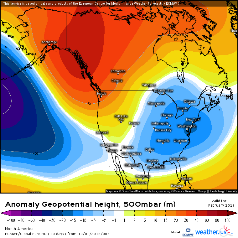
Finally a below normal day and many more to come the rest of the month. The ensembles continue to be very consistent with the strong Ridge out west and trough in the east actually the ridge becomes in a more favorable place around day 10 and Beyond. I actually like the period Between October 21st through the end of the month for a significant East Coast storm. We shall see

algae888- Advanced Forecaster

- Posts : 5311
Reputation : 46
Join date : 2013-02-05
Age : 62
Location : mt. vernon, new york
 Re: Long Range Thread 17.0
algae888 wrote:Finally a below normal day and many more to come the rest of the month. The ensembles continue to be very consistent with the strong Ridge out west and trough in the east actually the ridge becomes in a more favorable place around day 10 and Beyond. I actually like the period Between October 21st through the end of the month for a significant East Coast storm. We shall see
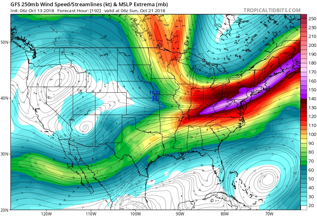
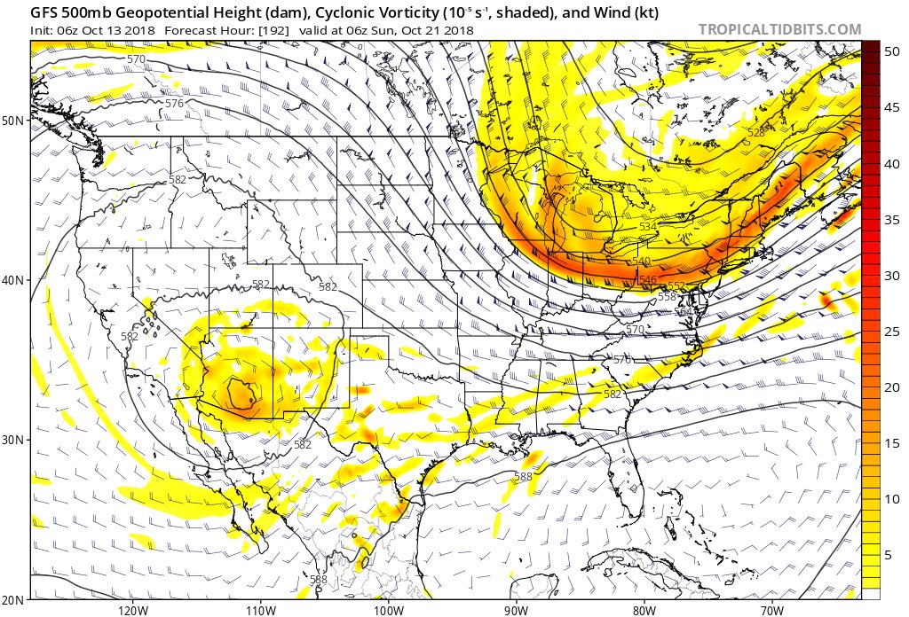
Beat me to that Nor signal - Destructive Interference in the PAC with a -MT signal and GOA LP pumping the PNA. This could be a very interesting last week timeframe to col off those highly anomalously warm Atlantic waters that have been pumping teh WAR this fall.
Heres you look from NFSWX on twitter:
_________________
Mugs
AKA:King: Snow Weenie
Self Proclaimed
WINTER 2014-15 : 55.12" +.02 for 6 coatings (avg. 35")
WINTER 2015-16 Total - 29.8" (Avg 35")
WINTER 2016-17 : 39.5" so far

amugs- Advanced Forecaster - Mod

- Posts : 15095
Reputation : 213
Join date : 2013-01-07
Age : 54
Location : Hillsdale,NJ
 Re: Long Range Thread 17.0
This is what we may expect in the winter if the MJO holds this line up rotation of 8,1,2!!
Why the colder east Indian Ocean and warmer west off Australia will promote a nice divergence zone for these Kelvin Waves to rotate through.

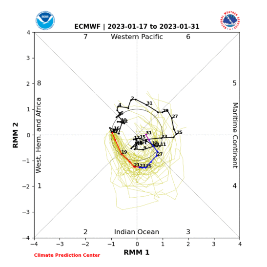
Why the colder east Indian Ocean and warmer west off Australia will promote a nice divergence zone for these Kelvin Waves to rotate through.


_________________
Mugs
AKA:King: Snow Weenie
Self Proclaimed
WINTER 2014-15 : 55.12" +.02 for 6 coatings (avg. 35")
WINTER 2015-16 Total - 29.8" (Avg 35")
WINTER 2016-17 : 39.5" so far

amugs- Advanced Forecaster - Mod

- Posts : 15095
Reputation : 213
Join date : 2013-01-07
Age : 54
Location : Hillsdale,NJ
 Re: Long Range Thread 17.0
Mugs that is a beautiful image let that keep doing a 360 right through the winter. What I like about this pattern is the ridge up into the Artic and its placement out west plus a very active subtropical jet. I think those two we can count on this winter. if this was December 1st heck even mid-november this board would be lighting up right nowamugs wrote:This is what we may expect in the winter if the MJO holds this line up rotation of 8,1,2!!
Why the colder east Indian Ocean and warmer west off Australia will promote a nice divergence zone for these Kelvin Waves to rotate through.

algae888- Advanced Forecaster

- Posts : 5311
Reputation : 46
Join date : 2013-02-05
Age : 62
Location : mt. vernon, new york
 Re: Long Range Thread 17.0
algae888 wrote:Mugs that is a beautiful image let that keep doing a 360 right through the winter. What I like about this pattern is the ridge up into the Artic and its placement out west plus a very active subtropical jet. I think those two we can count on this winter. if this was December 1st heck even mid-november this board would be lighting up right nowamugs wrote:This is what we may expect in the winter if the MJO holds this line up rotation of 8,1,2!!
Why the colder east Indian Ocean and warmer west off Australia will promote a nice divergence zone for these Kelvin Waves to rotate through.

_________________
Mugs
AKA:King: Snow Weenie
Self Proclaimed
WINTER 2014-15 : 55.12" +.02 for 6 coatings (avg. 35")
WINTER 2015-16 Total - 29.8" (Avg 35")
WINTER 2016-17 : 39.5" so far

amugs- Advanced Forecaster - Mod

- Posts : 15095
Reputation : 213
Join date : 2013-01-07
Age : 54
Location : Hillsdale,NJ
 Re: Long Range Thread 17.0
Interesting pattern next week will bring our coldest air of the season so far. The north Pacific Jet Stream goes poleward (shifts from west-east to south-north). That will form a +PNA which will squash the SE Ridge and allow a trough with a source air mass from the Arctic to settle in over the east 21st-26th. There is 2 or 3 storm coastal storm signals showing up in this time frame too. Something to watch for sure!!


_________________
_______________________________________________________________________________________________________
CLICK HERE to view NJ Strong Snowstorm Classifications
 Re: Long Range Thread 17.0
Latest ENSO weeklies:
Region 1+2... 0.4 (down 0.3)
Region 3... 0.7 (no change)
Region3.4... 0.6 (down 0.1)
Region 4... 0.9 (up 0.1)
Still looking good for a weak/moderate Modoki or central based Nino

nutleyblizzard- Senior Enthusiast

- Posts : 1954
Reputation : 41
Join date : 2014-01-30
Age : 58
Location : Nutley, new jersey
 Re: Long Range Thread 17.0
nutleyblizzard wrote:Latest ENSO weeklies:Region 1+2... 0.4 (down 0.3)Region 3... 0.7 (no change)Region3.4... 0.6 (down 0.1)Region 4... 0.9 (up 0.1)Still looking good for a weak/moderate Modoki or central based Nino
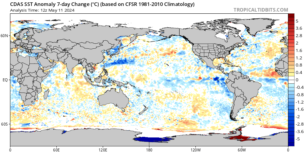
Not surprised. Lots of blue showing up off the Peruvian coast last 7 days. Meanwhile, warm pool in north-central PAC still lookin' good!
_________________
_______________________________________________________________________________________________________
CLICK HERE to view NJ Strong Snowstorm Classifications
 Re: Long Range Thread 17.0
Still very much like where my extended outlook sits with respect to almost every detail. I remain adamant that this is not a true pattern change......yet, though i may be off +/- each side of this cooler interlude by a couple days. I like how the FV3 looks overall, and believe that the EURO suite (and eventually lol) the GFS suite (playing into its typical cold season bias off too much eastern U.S. troughing) will come around to aligning with my thoughts presented earlier. Either way, I WILL be doing verification as able, but I like where I sit right now, and believe the true pattern change holds off until November.
rb924119- Meteorologist

- Posts : 6928
Reputation : 194
Join date : 2013-02-06
Age : 32
Location : Greentown, Pa
 Re: Long Range Thread 17.0
Rb I have to respectively disagree with this analysis. Let's just look at the facts we've gone from a plus 9in temperature departures the first 11 days to October to around a -6 temperature departure from the 12th through the 22nd using Guidance the next 5 days. We've gone from Ridge after Ridge and anomalous ones at that to trough after trough which are also very anomalous some 15 degrees below normal tomorrow and the upcoming weekend. I do agree however that the late October through the first week of November will feature the coldest and possibly most volatile weather but we are definitely in a pattern change right now. Going forward I feel that we will have a relatively tranquil period from around mid November through mid to late December as the atmosphere kind of relaxes from the extreme patterns she has been in. El ninos are usually back-loaded Winters and just through my experience when the atmosphere goes through extremes it tends to calm down for a period of time. I like where we are at this point heading into Winter should be fun timesrb924119 wrote:Still very much like where my extended outlook sits with respect to almost every detail. I remain adamant that this is not a true pattern change......yet, though i may be off +/- each side of this cooler interlude by a couple days. I like how the FV3 looks overall, and believe that the EURO suite (and eventually lol) the GFS suite (playing into its typical cold season bias off too much eastern U.S. troughing) will come around to aligning with my thoughts presented earlier. Either way, I WILL be doing verification as able, but I like where I sit right now, and believe the true pattern change holds off until November.

algae888- Advanced Forecaster

- Posts : 5311
Reputation : 46
Join date : 2013-02-05
Age : 62
Location : mt. vernon, new york
 Re: Long Range Thread 17.0
Agree with you Al.
The pattern turns more robust and anomalous the last week of October into November. Our first snow, especially N&W of NYC, is probable in that time period.
The pattern turns more robust and anomalous the last week of October into November. Our first snow, especially N&W of NYC, is probable in that time period.
_________________
_______________________________________________________________________________________________________
CLICK HERE to view NJ Strong Snowstorm Classifications
 Re: Long Range Thread 17.0
algae888 wrote:Rb I have to respectively disagree with this analysis. Let's just look at the facts we've gone from a plus 9in temperature departures the first 11 days to October to around a -6 temperature departure from the 12th through the 22nd using Guidance the next 5 days. We've gone from Ridge after Ridge and anomalous ones at that to trough after trough which are also very anomalous some 15 degrees below normal tomorrow and the upcoming weekend. I do agree however that the late October through the first week of November will feature the coldest and possibly most volatile weather but we are definitely in a pattern change right now. Going forward I feel that we will have a relatively tranquil period from around mid November through mid to late December as the atmosphere kind of relaxes from the extreme patterns she has been in. El ninos are usually back-loaded Winters and just through my experience when the atmosphere goes through extremes it tends to calm down for a period of time. I like where we are at this point heading into Winter should be fun timesrb924119 wrote:Still very much like where my extended outlook sits with respect to almost every detail. I remain adamant that this is not a true pattern change......yet, though i may be off +/- each side of this cooler interlude by a couple days. I like how the FV3 looks overall, and believe that the EURO suite (and eventually lol) the GFS suite (playing into its typical cold season bias off too much eastern U.S. troughing) will come around to aligning with my thoughts presented earlier. Either way, I WILL be doing verification as able, but I like where I sit right now, and believe the true pattern change holds off until November.
I like disagreement!!!! It fosters discussion!!! To your first point; yes, cooler air did come in for the 12th-14th, but then was wiped out in our region by the warm surge ahead of the system that ushered in our current cool period. The rest of the period falls right into place with the corresponding part to my outlook. While we are seeing an enhanced frequency of troughing, and will be biased cool during this period, we are still experiencing interludes of riding and anomalous warmth; the warmth during this stretch will just not be enough to counter the cold. However, as we look to the future, I believe the warmth will begin out dueling the cold again, at least for a time based on the factors outlined in the outlook, even though we will still be seeing troughs enter our region more frequently than before. I think we may be simply arguing over semantics here. My interpretation of a true pattern change is when we have significant changes for a substantial duration. So, while we are seeing these troughs, they are not "locking in"; they are coming and going with ridges and returning warmth in between. This is a transient pattern to me. It has amplitude, yes, but nothing has staying power yet, and that is because we have conflicting signals around the globe. My argument is that we WILL see these auspiciously align a few weeks from now, and then we will also start seeing positive feedbacks beginning to develop that will augment and help sustain the pattern where we have persistent troughing over the eastern CONUS that then gets enhanced/reinforced, not just replaced and then rinsed, washed, and repeated.
You seem to be coming from the perspective that the pattern has changed away from the persistent ridging that was in place earlier in the Autumn, and you have no argument from me there. I simply am considering this as more of a transitional period than a true pattern change. Does that maybe clarify my stance a bit better?
As a further example of the warmth trying to fight, think back to two weeks ago when persistent troughing was modeled to begin taking over at this current time. Look at what's actually verifying; ridge, trough, ridge trough, etc. I believe that the models are currently over-playing the "cold card" right now and do not make sense with other components of their forecast (e.g. the MJO forecasts, changes in the Niño 1.2 region, western Atlantic SST anomalies). This is also entirely subjective on my end, and could very well be off; only time will tell. At face value, while my global prognostications seem to have been very close to reality (so far), my future temperature predictions appear to be in jeopardy. However, I would just like to offer the following images as something to note with caution (I also am running out of time before I have to go to work):
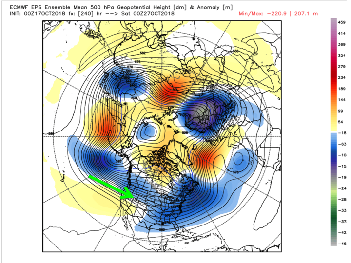
The above is a Day 10 EPS forecast of 500 hPa heights (black contours) and their respective anomalies (color shadings), with the green arrow indicating the progged fast Pacific Jet and resultant influx of milder Pacific air into our pattern. Therefore, I think cold will be moderated in addition to my other factors. Secondly, this also supports the idea of transience in the pattern.
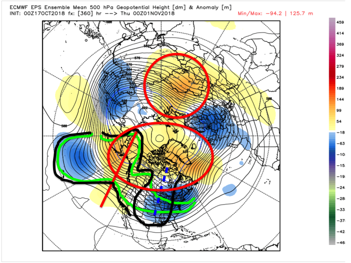
The above is same image at Day 15. The green lines denote the streamflow as depicted by the model, while the black line denotes where we should see this correct based on the progged height anomalies; time-mean troughing centered between the mountains with more ridging becoming evident in due time as the ensemble clusters tighten and fall into line with other factors. HOWEVER, note that this is dated as 00z November 1st, which is why I have the two red circles. Those circles denote the precursor pattern that will enact our TRUE pattern change. That 70N/70E ridging is a key, with bolstering high-latitude blocking developing as a response to Rossby wave train amplification from a strengthening MJO pulse and split flow regime likely leading to a large interior cyclogenesis event. We always say a strong cutter helps to change our pattern; well folks, there are the beginnings of our true change, at least in my opinion.
Hopefully this helps clarify some things, but if not, please continue the discussion and I will add input as able (my schedule will be kind of tight these next four days, so it may take me some time to get back on here in a meaningful way).
Last edited by rb924119 on Wed Oct 17, 2018 3:49 pm; edited 1 time in total
rb924119- Meteorologist

- Posts : 6928
Reputation : 194
Join date : 2013-02-06
Age : 32
Location : Greentown, Pa
 Re: Long Range Thread 17.0
rb924119 wrote:algae888 wrote:Rb I have to respectively disagree with this analysis. Let's just look at the facts we've gone from a plus 9in temperature departures the first 11 days to October to around a -6 temperature departure from the 12th through the 22nd using Guidance the next 5 days. We've gone from Ridge after Ridge and anomalous ones at that to trough after trough which are also very anomalous some 15 degrees below normal tomorrow and the upcoming weekend. I do agree however that the late October through the first week of November will feature the coldest and possibly most volatile weather but we are definitely in a pattern change right now. Going forward I feel that we will have a relatively tranquil period from around mid November through mid to late December as the atmosphere kind of relaxes from the extreme patterns she has been in. El ninos are usually back-loaded Winters and just through my experience when the atmosphere goes through extremes it tends to calm down for a period of time. I like where we are at this point heading into Winter should be fun timesrb924119 wrote:Still very much like where my extended outlook sits with respect to almost every detail. I remain adamant that this is not a true pattern change......yet, though i may be off +/- each side of this cooler interlude by a couple days. I like how the FV3 looks overall, and believe that the EURO suite (and eventually lol) the GFS suite (playing into its typical cold season bias off too much eastern U.S. troughing) will come around to aligning with my thoughts presented earlier. Either way, I WILL be doing verification as able, but I like where I sit right now, and believe the true pattern change holds off until November.
I like disagreement!!!! It fosters discussion!!! To your first point; yes, cooler air did come in for the 12th-14th, but then was wiped out in our region by the warm surge ahead of the system that ushered in our current cool period. The rest of the period falls right into place with the corresponding part to my outlook. While we are seeing an enhanced frequency of troughing, and will be biased cool during this period, we are still experiencing interludes of riding and anomalous warmth; the warmth during this stretch will just not be enough to counter the cold. However, as we look to the future, I believe the warmth will begin out dueling the cold again, at least for a time based on the factors outlined in the outlook, even though we will still be seeing troughs enter our region more frequently than before. I think we may be simply arguing over semantics here. My interpretation of a true pattern change is when we have significant changes for a substantial duration. So, while we are seeing these troughs, they are not "locking in"; they are coming and going with ridges and returning warmth in between. This is a transient pattern to me. It has amplitude, yes, but nothing has staying power yet, and that is because we have conflicting signals around the globe. My argument is that we WILL see these auspiciously align a few weeks from now, and then we will also start seeing positive feedbacks beginning to develop that will augment and help sustain the pattern where we have persistent troughing over the eastern CONUS that then gets enhanced/reinforced, not just replaced and then rinsed, washed, and repeated.
You seem to be coming from the perspective that the pattern has changed away from the persistent ridging that was in place earlier in the Autumn, and you have no argument from me there. I simply am considering this as more of a transitional period than a true pattern change. Does that maybe clarify my stance a bit better?
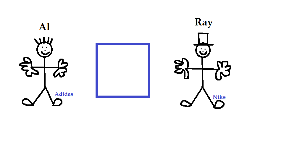
From my vantage point you guys are looking at the same box, but from different perspectives. I personally agree with both points. I def agree that the pattern has changed relative to the miserable pattern we saw back in Aug and most if not all of Sept...hot, hazy, humid compliments of the dreaded SE ridging. But I can see what Ray is saying in that what we are experiencing now and over the next few weeks is more of a transitional pattern into an eventual more consistent or sustainable pattern.
Ray Im not sure why I gave you a top hat but that's you on the right...lol
Last edited by sroc4 on Wed Oct 17, 2018 4:11 pm; edited 2 times in total
_________________
"In weather and in life, there's no winning and losing; there's only winning and learning."
WINTER 2012/2013 TOTALS 43.65"WINTER 2017/2018 TOTALS 62.85" WINTER 2022/2023 TOTALS 4.9"
WINTER 2013/2014 TOTALS 64.85"WINTER 2018/2019 TOTALS 14.25" WINTER 2023/2024 TOTALS 13.1"
WINTER 2014/2015 TOTALS 71.20"WINTER 2019/2020 TOTALS 6.35"
WINTER 2015/2016 TOTALS 35.00"WINTER 2020/2021 TOTALS 37.75"
WINTER 2016/2017 TOTALS 42.25"WINTER 2021/2022 TOTALS 31.65"

sroc4- Admin

- Posts : 8354
Reputation : 302
Join date : 2013-01-07
Location : Wading River, LI
 Re: Long Range Thread 17.0
Scott you are too funny And yes rb your last paragraph is exactly what I'm talking about

algae888- Advanced Forecaster

- Posts : 5311
Reputation : 46
Join date : 2013-02-05
Age : 62
Location : mt. vernon, new york
 Re: Long Range Thread 17.0
Sorry guys, I was enhancing my response lol please see my edited version haha
rb924119- Meteorologist

- Posts : 6928
Reputation : 194
Join date : 2013-02-06
Age : 32
Location : Greentown, Pa
 Re: Long Range Thread 17.0
I was watching Lee Goldberg earlier. He was asked if there was any correlation with the colder temps we're having now and if its a prelude to this winter. While he said that October weather conditions and the winters that follow really have no connection, he did give a forecast of a slow start to winter followed by and I quote... "A January and February rage".

nutleyblizzard- Senior Enthusiast

- Posts : 1954
Reputation : 41
Join date : 2014-01-30
Age : 58
Location : Nutley, new jersey
 Re: Long Range Thread 17.0
There is too much high latitude blocking overall for this pattern IMO to tbe transient and ransition for a solid 2 weeks but rather hit and hold. Last weeknof Rocktober to firat week of July. You have a massive PAC jet extension that will enhance to EPO region, WPO, PA and AO and NAO. Some argue that low solar and the Haley Sun Cycle of 22 years and 240 year sun Cycle along with 120 year cycle and 480 +/- a few years, is taking hold. They are aligning as are the Big Boy planets of Jupiter, Saturn, Uranus, Pluto and Neptune as I have read from John Casey.
I see the PV perturbed and Canada an ice box ready to release her fury on us below. Speaking of the dynamic storm potential exists for the last week of October and through the first week of November. Tropcial moisture laden air clashing with very anomlously cold arctic type air = hybrid intense stormsssss. Warm Atlantic water to feed this and cold air to explode this. Bad recipe for some but good for weather weenies. Just my .02.
I see the PV perturbed and Canada an ice box ready to release her fury on us below. Speaking of the dynamic storm potential exists for the last week of October and through the first week of November. Tropcial moisture laden air clashing with very anomlously cold arctic type air = hybrid intense stormsssss. Warm Atlantic water to feed this and cold air to explode this. Bad recipe for some but good for weather weenies. Just my .02.
_________________
Mugs
AKA:King: Snow Weenie
Self Proclaimed
WINTER 2014-15 : 55.12" +.02 for 6 coatings (avg. 35")
WINTER 2015-16 Total - 29.8" (Avg 35")
WINTER 2016-17 : 39.5" so far

amugs- Advanced Forecaster - Mod

- Posts : 15095
Reputation : 213
Join date : 2013-01-07
Age : 54
Location : Hillsdale,NJ
 Re: Long Range Thread 17.0

_________________
Mugs
AKA:King: Snow Weenie
Self Proclaimed
WINTER 2014-15 : 55.12" +.02 for 6 coatings (avg. 35")
WINTER 2015-16 Total - 29.8" (Avg 35")
WINTER 2016-17 : 39.5" so far

amugs- Advanced Forecaster - Mod

- Posts : 15095
Reputation : 213
Join date : 2013-01-07
Age : 54
Location : Hillsdale,NJ
 Re: Long Range Thread 17.0
NOAA climate prediction center came out with their winter forecast. For our forum area normal to above normal temperatures and below normal precipitation. In direct contrast with the EURO
Guest- Guest
 Re: Long Range Thread 17.0
syosnow94 wrote:NOAA climate prediction center came out with their winter forecast. For our forum area normal to above normal temperatures and below normal precipitation. In direct contrast with the EURO
They lost all their blue crayons Jimmy.
_________________
"In weather and in life, there's no winning and losing; there's only winning and learning."
WINTER 2012/2013 TOTALS 43.65"WINTER 2017/2018 TOTALS 62.85" WINTER 2022/2023 TOTALS 4.9"
WINTER 2013/2014 TOTALS 64.85"WINTER 2018/2019 TOTALS 14.25" WINTER 2023/2024 TOTALS 13.1"
WINTER 2014/2015 TOTALS 71.20"WINTER 2019/2020 TOTALS 6.35"
WINTER 2015/2016 TOTALS 35.00"WINTER 2020/2021 TOTALS 37.75"
WINTER 2016/2017 TOTALS 42.25"WINTER 2021/2022 TOTALS 31.65"

sroc4- Admin

- Posts : 8354
Reputation : 302
Join date : 2013-01-07
Location : Wading River, LI
 Re: Long Range Thread 17.0
I DONT NEED NO STINKING WEATHER FORECAST. I KNOW WINTER IS COMING CAUSE CP STARTED POSTING AGAIN
Guest- Guest
 Re: Long Range Thread 17.0
I can't recall NOAA ever predicting below normal temps for the Northeast. Same map different year.syosnow94 wrote:NOAA climate prediction center came out with their winter forecast. For our forum area normal to above normal temperatures and below normal precipitation. In direct contrast with the EURO

nutleyblizzard- Senior Enthusiast

- Posts : 1954
Reputation : 41
Join date : 2014-01-30
Age : 58
Location : Nutley, new jersey
 Re: Long Range Thread 17.0
Noaa always goes warm for the winter

Snow88- Senior Enthusiast

- Posts : 2193
Reputation : 4
Join date : 2013-01-09
Age : 35
Location : Brooklyn, NY
 Re: Long Range Thread 17.0
Meanwhile JB is going very cold and snowy rivaling 2013/14.Snow88 wrote:Noaa always goes warm for the winter

nutleyblizzard- Senior Enthusiast

- Posts : 1954
Reputation : 41
Join date : 2014-01-30
Age : 58
Location : Nutley, new jersey
Page 5 of 41 •  1, 2, 3, 4, 5, 6 ... 23 ... 41
Page 5 of 41
Permissions in this forum:
You cannot reply to topics in this forum|
|
|

 Home
Home