
 Search
Long Range Thread 18.0
Page 19 of 36 •  1 ... 11 ... 18, 19, 20 ... 27 ... 36
 ![]()
Re: Long Range Thread 18.0
![]() by rb924119 Tue Jan 29, 2019 6:02 pm
by rb924119 Tue Jan 29, 2019 6:02 pm
rb924119- Meteorologist

- Posts : 6928
Join date : 2013-02-06
Re: Long Range Thread 18.0
![]() by Grselig Tue Jan 29, 2019 6:11 pm
by Grselig Tue Jan 29, 2019 6:11 pm
rb924119 wrote:Don’t look now, but the EURO Op and Control show some light breaking through the current abyss. Just sayin’.......some discussion is better than none, no?
Its winter. One actual storm is better than none. Even if nothing works out, its more fun the track, than have no hope. Good to see you back.
Grselig- Senior Enthusiast

- Posts : 1408
Join date : 2013-03-04
Re: Long Range Thread 18.0
![]() by nutleyblizzard Tue Jan 29, 2019 6:30 pm
by nutleyblizzard Tue Jan 29, 2019 6:30 pm
Yep I see the 10 day threat on the Euro. Way out in fantasy land but at least its not a cutter like the models have portrayed all winter.rb924119 wrote:Don’t look now, but the EURO Op and Control show some light breaking through the current abyss. Just sayin’.......

nutleyblizzard- Senior Enthusiast
- Posts : 1954
Reputation : 41
Join date : 2014-01-30
Age : 58
Location : Nutley, new jersey
Re: Long Range Thread 18.0
![]() by amugs Tue Jan 29, 2019 7:23 pm
by amugs Tue Jan 29, 2019 7:23 pm
_________________
Mugs
AKA:King: Snow Weenie
Self Proclaimed
WINTER 2014-15 : 55.12" +.02 for 6 coatings (avg. 35")
WINTER 2015-16 Total - 29.8" (Avg 35")
WINTER 2016-17 : 39.5" so far

amugs- Advanced Forecaster - Mod

- Posts : 15095
Reputation : 213
Join date : 2013-01-07
Age : 54
Location : Hillsdale,NJ
Re: Long Range Thread 18.0
![]() by Guest Tue Jan 29, 2019 7:34 pm
by Guest Tue Jan 29, 2019 7:34 pm
amugs wrote:Look at 2/6-7 storm it's there. Need that NAO and 50/50 block as we have said all winter and we'll be dancing
The 1/22 storm looked good
The 1/29 storm looked good
The 2/3 storm looked good.
Before that tons of storms looked good
The pattern and storms are coming in about a week(since early December). Except it never happens
Not
Pickingnon you and your eternal optimism Mugsy but time to give it up.
Love ya
Guest- Guest
Re: Long Range Thread 18.0
![]() by amugs Tue Jan 29, 2019 7:56 pm
by amugs Tue Jan 29, 2019 7:56 pm
Smooches back at you Jimmy and get cozy till March 15th roll's in for ya LOL!!
_________________
Mugs
AKA:King: Snow Weenie
Self Proclaimed
WINTER 2014-15 : 55.12" +.02 for 6 coatings (avg. 35")
WINTER 2015-16 Total - 29.8" (Avg 35")
WINTER 2016-17 : 39.5" so far
amugs- Advanced Forecaster - Mod
- Posts : 15095
Reputation : 213
Join date : 2013-01-07
Age : 54
Location : Hillsdale,NJ
Re: Long Range Thread 18.0
![]() by skinsfan1177 Tue Jan 29, 2019 8:00 pm
by skinsfan1177 Tue Jan 29, 2019 8:00 pm

skinsfan1177- Senior Enthusiast
- Posts : 4485
Reputation : 35
Join date : 2013-01-07
Age : 46
Location : Point Pleasant Boro
Re: Long Range Thread 18.0
![]() by heehaw453 Wed Jan 30, 2019 12:49 pm
by heehaw453 Wed Jan 30, 2019 12:49 pm
That concern has to be there at this point. I wouldn't be shocked to see February skunk us too. And for the most part this meteorological winter is bad area wide for this forum.
heehaw453- Advanced Forecaster

- Posts : 3906
Reputation : 86
Join date : 2014-01-20
Location : Bedminster Township, PA Elevation 600' ASL
Re: Long Range Thread 18.0
![]() by CPcantmeasuresnow Wed Jan 30, 2019 1:40 pm
by CPcantmeasuresnow Wed Jan 30, 2019 1:40 pm
heehaw453 wrote:
That concern has to be there at this point. I wouldn't be shocked to see February skunk us too. And for the most part this meteorological winter is bad area wide for this forum.
Yes February for our entire area is the shortest yet snowiest month historically. However 3 of the last 4 years March has been the snowiest month.
WTS, I don't expect either month to deliver.

CPcantmeasuresnow- Wx Statistician Guru

- Posts : 7274
Reputation : 230
Join date : 2013-01-07
Age : 103
Location : Eastern Orange County, NY
Re: Long Range Thread 18.0
![]() by algae888 Wed Jan 30, 2019 7:22 pm
by algae888 Wed Jan 30, 2019 7:22 pm

algae888- Advanced Forecaster
- Posts : 5311
Reputation : 46
Join date : 2013-02-05
Age : 62
Location : mt. vernon, new york
Re: Long Range Thread 18.0
![]() by mwilli5783 Wed Jan 30, 2019 7:41 pm
by mwilli5783 Wed Jan 30, 2019 7:41 pm
mwilli5783- Posts : 146
Reputation : 9
Join date : 2013-01-23
Age : 69
Location : hempstead n.y
Re: Long Range Thread 18.0
![]() by amugs Wed Jan 30, 2019 7:59 pm
by amugs Wed Jan 30, 2019 7:59 pm
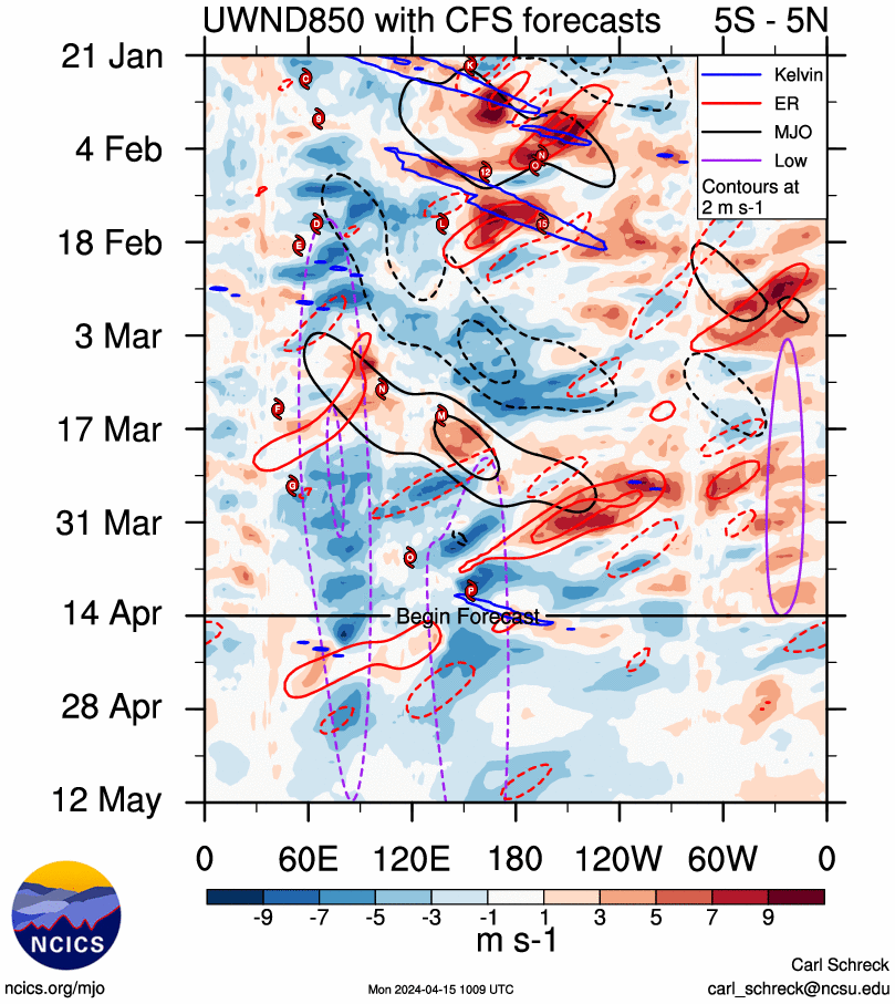
Here is the map he posted. Look at the red colors and that is the wave going to phase 8 and then to 1 possibly. There is no resistance yet in the PAC to keep the wave from dying off but should be proposed by the convective warm water in phase 8 through 3. Well see with that?
_________________
Mugs
AKA:King: Snow Weenie
Self Proclaimed
WINTER 2014-15 : 55.12" +.02 for 6 coatings (avg. 35")
WINTER 2015-16 Total - 29.8" (Avg 35")
WINTER 2016-17 : 39.5" so far
amugs- Advanced Forecaster - Mod
- Posts : 15095
Reputation : 213
Join date : 2013-01-07
Age : 54
Location : Hillsdale,NJ
Re: Long Range Thread 18.0
![]() by Irish Wed Jan 30, 2019 8:35 pm
by Irish Wed Jan 30, 2019 8:35 pm

Irish- Pro Enthusiast

- Posts : 788
Reputation : 19
Join date : 2019-01-16
Age : 45
Location : Old Bridge, NJ
Re: Long Range Thread 18.0
![]() by jmanley32 Thu Jan 31, 2019 12:02 am
by jmanley32 Thu Jan 31, 2019 12:02 am
Where are you guys looking? None of the Euro ensemble members or 00z or 12z show any snow of sig, in the 10 day. Am I looking at something wrong?nutleyblizzard wrote:Yep I see the 10 day threat on the Euro. Way out in fantasy land but at least its not a cutter like the models have portrayed all winter.rb924119 wrote:Don’t look now, but the EURO Op and Control show some light breaking through the current abyss. Just sayin’.......

jmanley32- Senior Enthusiast
- Posts : 20535
Reputation : 108
Join date : 2013-12-12
Age : 43
Location : Yonkers, NY
Re: Long Range Thread 18.0
![]() by rb924119 Thu Jan 31, 2019 12:03 am
by rb924119 Thu Jan 31, 2019 12:03 am
Irish wrote:Wow, i literally read amugs post and feel like he's speaking in an alien tongue.
Unfortunately, Tom (the author of the post mugs quoted) doesn’t l visit our family here too often anymore, but if you would have been here when he was a more frequent poster you would have quickly learned that’s just Tom ahaha you need a dictionary on hand when he posts, as well as a seasoned meteorology translator lmao I have a couple of pending posts that I want to get to, and will add this one to the list (if somebody doesn’t get to it first). I’m hoping to be able to sit down later tomorrow and catch up a bit, though lol
rb924119- Meteorologist
- Posts : 6928
Reputation : 194
Join date : 2013-02-06
Age : 32
Location : Greentown, Pa
Re: Long Range Thread 18.0
![]() by docstox12 Thu Jan 31, 2019 3:38 am
by docstox12 Thu Jan 31, 2019 3:38 am
amugs wrote:Okay from Isotherm that we see the transition amto a HighbLatitude block regime and better harmimous PAC as a result of the rosy wave or westward win burst at the dateline and just east forecasted and happening. This will cause the SOI to drop and cattlemprod the PAC as well for a better EPO and PNA couplet. Indices and end will transition to see g this so if they take a step back dot FREAK OUT!!
Here is the map he posted. Look at the red colors and that is the wave going to phase 8 and then to 1 possibly. There is no resistance yet in the PAC to keep the wave from dying off but should be proposed by the convective warm water in phase 8 through 3. Well see with that?
Lee Goldberg has temps in the 40's and 50's next week with possible rain on Wednesday.That would burn the first week of February.How does that relate to what you just posted here Mugsy?

docstox12- Wx Statistician Guru
- Posts : 8530
Reputation : 222
Join date : 2013-01-07
Age : 73
Location : Monroe NY
Re: Long Range Thread 18.0
![]() by SENJsnowman Thu Jan 31, 2019 7:31 am
by SENJsnowman Thu Jan 31, 2019 7:31 am
docstox12 wrote:
Lee Goldberg has temps in the 40's and 50's next week with possible rain on Wednesday.That would burn the first week of February.How does that relate to what you just posted here Mugsy?
So, there is def a disparity b/w what Mugsy is sayin' and what the projections are showin'. But, I've seen Mugs be a lot more right than computers and their human spoke-folk before...so I'm just gonna sit back and watch what happens.
In Mugs We Trust!
SENJsnowman- Senior Enthusiast
- Posts : 1189
Reputation : 61
Join date : 2017-01-06
Age : 51
Location : Bayville, NJ
Re: Long Range Thread 18.0
![]() by heehaw453 Thu Jan 31, 2019 8:21 am
by heehaw453 Thu Jan 31, 2019 8:21 am
heehaw453- Advanced Forecaster
- Posts : 3906
Reputation : 86
Join date : 2014-01-20
Location : Bedminster Township, PA Elevation 600' ASL
Re: Long Range Thread 18.0
![]() by sroc4 Thu Jan 31, 2019 8:24 am
by sroc4 Thu Jan 31, 2019 8:24 am
docstox12 wrote:amugs wrote:Okay from Isotherm that we see the transition amto a HighbLatitude block regime and better harmimous PAC as a result of the rosy wave or westward win burst at the dateline and just east forecasted and happening. This will cause the SOI to drop and cattlemprod the PAC as well for a better EPO and PNA couplet. Indices and end will transition to see g this so if they take a step back dot FREAK OUT!!
Here is the map he posted. Look at the red colors and that is the wave going to phase 8 and then to 1 possibly. There is no resistance yet in the PAC to keep the wave from dying off but should be proposed by the convective warm water in phase 8 through 3. Well see with that?
Lee Goldberg has temps in the 40's and 50's next week with possible rain on Wednesday.That would burn the first week of February.How does that relate to what you just posted here Mugsy?
In short Doc, as Ive been noting the MJO in the warm phases have been consistently offering the resistance to the more favorable factors(results of the strat warming event that has led us to have a large piece of the PV on our side of the hemisphere). Sum of all moving parts. Since we are still in those warm phases, and have been since mid month, as soon as the pattern relaxes, those effects come right back. That is why we rebound from extreme cold back to 40's-50's and rain again by next week. Like the rubber band effect. But in English Mugsys posts is saying that there should be a continued eastward progression through the warm phases to the cold phases and or at least the amplitude of noted MJO wave should diminish such that the other factors should become more favorable again to launch the cold. With both GEFS and Euro completely diff in their prediction for the MJO wave at the moment I hesitate to be any more optimistic as to say I feel confident we see the cold push back again but will it result in a more favorable outcome, or do we quickly recycle yet again back into warm phases of the MJO with amplitude resulting in the storm track in close to the coast and our area warm sectored?
The SOI is another area that we likely need to see switch around. This too is discussed above. The SOI with the exception of brief intervals has remained neutral to even La Nina like. In short the SOI is a measure of the relative pressure differences between Darwin Australia and Tahit which in turn gives us an indicator of the equatorial trade winds. Positive state of the SOI then the trades flow from east to west(easterly) La Nina state, negative SOI indicates the trades flowing more west to east (westerly)El nino state. Although we are supposed to be in a weak El Nino the SOI really has never indicatd this. This has been a direct result of the MJO in the crappy phases. Phases 3-5 indicate lower pressure near the Darwin Australia region. If low pressure there(due to persistent MJO pulses) and HP(relatively speaking) to the east in Tahiti the net flow along the equator is from HP to LP, or from east to west (easterly/La Nina like. Again a resistance to the pattern results in our neck of the woods as result. The image above andwhat Mugs says Tom is saying is that hopefully there will be a westerly wind burst, ie: the MJO relaxes and or moves east changing the pressure differences which allow the trades to stwich to a westerly component. The result of this will remove some of the resistance we have in our neck of the woods. While optimism is there I hesitate to believe it just yet until I see what happens with this MJO pulse.


_________________
"In weather and in life, there's no winning and losing; there's only winning and learning."
WINTER 2012/2013 TOTALS 43.65"WINTER 2017/2018 TOTALS 62.85" WINTER 2022/2023 TOTALS 4.9"
WINTER 2013/2014 TOTALS 64.85"WINTER 2018/2019 TOTALS 14.25" WINTER 2023/2024 TOTALS 13.1"
WINTER 2014/2015 TOTALS 71.20"WINTER 2019/2020 TOTALS 6.35"
WINTER 2015/2016 TOTALS 35.00"WINTER 2020/2021 TOTALS 37.75"
WINTER 2016/2017 TOTALS 42.25"WINTER 2021/2022 TOTALS 31.65"

sroc4- Admin

- Posts : 8354
Reputation : 302
Join date : 2013-01-07
Location : Wading River, LI
Re: Long Range Thread 18.0
![]() by heehaw453 Thu Jan 31, 2019 8:36 am
by heehaw453 Thu Jan 31, 2019 8:36 am
sroc4 wrote:docstox12 wrote:amugs wrote:Okay from Isotherm that we see the transition amto a HighbLatitude block regime and better harmimous PAC as a result of the rosy wave or westward win burst at the dateline and just east forecasted and happening. This will cause the SOI to drop and cattlemprod the PAC as well for a better EPO and PNA couplet. Indices and end will transition to see g this so if they take a step back dot FREAK OUT!!
Here is the map he posted. Look at the red colors and that is the wave going to phase 8 and then to 1 possibly. There is no resistance yet in the PAC to keep the wave from dying off but should be proposed by the convective warm water in phase 8 through 3. Well see with that?
Lee Goldberg has temps in the 40's and 50's next week with possible rain on Wednesday.That would burn the first week of February.How does that relate to what you just posted here Mugsy?
In short Doc, as Ive been noting the MJO in the warm phases have been consistently offering the resistance to the more favorable factors(results of the strat warming event that has led us to have a large piece of the PV on our side of the hemisphere). Sum of all moving parts. Since we are still in those warm phases, and have been since mid month, as soon as the pattern relaxes, those effects come right back. That is why we rebound from extreme cold back to 40's-50's and rain again by next week. Like the rubber band effect. But in English Mugsys posts is saying that there should be a continued eastward progression through the warm phases to the cold phases and or at least the amplitude of noted MJO wave should diminish such that the other factors should become more favorable again to launch the cold. With both GEFS and Euro completely diff in their prediction for the MJO wave at the moment I hesitate to be any more optimistic as to say I feel confident we see the cold push back again but will it result in a more favorable outcome, or do we quickly recycle yet again back into warm phases of the MJO with amplitude resulting in the storm track in close to the coast and our area warm sectored?
The SOI is another area that we likely need to see switch around. This too is discussed above. The SOI with the exception of brief intervals has remained neutral to even La Nina like. In short the SOI is a measure of the relative pressure differences between Darwin Australia and Tahit which in turn gives us an indicator of the equatorial trade winds. Positive state of the SOI then the trades flow from east to west(easterly) La Nina state, negative SOI indicates the trades flowing more west to east (westerly)El nino state. Although we are supposed to be in a weak El Nino the SOI really has never indicatd this. This has been a direct result of the MJO in the crappy phases. Phases 3-5 indicate lower pressure near the Darwin Australia region. If low pressure there(due to persistent MJO pulses) and HP(relatively speaking) to the east in Tahiti the net flow along the equator is from HP to LP, or from east to west (easterly/La Nina like. Again a resistance to the pattern results in our neck of the woods as result. The image above andwhat Mugs says Tom is saying is that hopefully there will be a westerly wind burst, ie: the MJO relaxes and or moves east changing the pressure differences which allow the trades to stwich to a westerly component. The result of this will remove some of the resistance we have in our neck of the woods. While optimism is there I hesitate to believe it just yet until I see what happens with this MJO pulse.
Do you think MJO going into 8 stops the cutter trajectory or do we need that coupled with The right blocking setup? There really hasn’t been one BM nor’easter this winter.
heehaw453- Advanced Forecaster
- Posts : 3906
Reputation : 86
Join date : 2014-01-20
Location : Bedminster Township, PA Elevation 600' ASL
Re: Long Range Thread 18.0
![]() by Guest Thu Jan 31, 2019 9:40 am
by Guest Thu Jan 31, 2019 9:40 am
Then next week we are treated to 2 GLC’s with temps in the mid 40’s and rain bringing us to at least February 10th with no more than a couple of coatings IN THE LAST 3 MONTHS for most of the board.
Guest- Guest
Re: Long Range Thread 18.0
![]() by CPcantmeasuresnow Thu Jan 31, 2019 11:30 am
by CPcantmeasuresnow Thu Jan 31, 2019 11:30 am
syosnow94 wrote:Here in plain English. After this brief 2 day visit from the polar vortex we warm up this weekend to near normal temps.
Then next week we are treated to 2 GLC’s with temps in the mid 40’s and rain bringing us to at least February 10th with no more than a couple of coatings IN THE LAST 3 MONTHS for most of the board.
Frank Deleted Math's Dec 15th poll, which we all know started the downward spiral of this winter, a few days ago. It is scientific fact that there is a two week lag time between deleting an item on a weather forum that was a hex on all pattern changes, and the actual pattern change itself. Based on the day that Frank deleted the thread, we will change to a cold and snowy pattern sometime between Feb 8th and Feb 12th.
That my friend is scientific fact and will happen, take it to the bank.
CPcantmeasuresnow- Wx Statistician Guru
- Posts : 7274
Reputation : 230
Join date : 2013-01-07
Age : 103
Location : Eastern Orange County, NY
Re: Long Range Thread 18.0
![]() by Guest Thu Jan 31, 2019 11:59 am
by Guest Thu Jan 31, 2019 11:59 am
CPcantmeasuresnow wrote:syosnow94 wrote:Here in plain English. After this brief 2 day visit from the polar vortex we warm up this weekend to near normal temps.
Then next week we are treated to 2 GLC’s with temps in the mid 40’s and rain bringing us to at least February 10th with no more than a couple of coatings IN THE LAST 3 MONTHS for most of the board.
Frank Deleted Math's Dec 15th poll, which we all know started the downward spiral of this winter, a few days ago. It is scientific fact that there is a two week lag time between deleting an item on a weather forum that was a hex on all pattern changes, and the actual pattern change itself. Based on the day that Frank deleted the thread, we will change to a cold and snowy pattern sometime between Feb 8th and Feb 12th.
That my friend is scientific fact and will happen, take it to the bank.
Good one.
Guest- Guest
Re: Long Range Thread 18.0
![]() by sroc4 Thu Jan 31, 2019 12:08 pm
by sroc4 Thu Jan 31, 2019 12:08 pm
heehaw453 wrote:
Do you think MJO going into 8 stops the cutter trajectory or do we need that coupled with The right blocking setup? There really hasn’t been one BM nor’easter this winter.
IF, and thats a big IF we can get the MJO into phase 8 then yes I do think we can stop the current storm track too far west for our areas. Will there be other factors that go against us then?? Dont know yet, but phase 8 drastically improves our odds. Its actually the phase 8 that helps the high lat blocking to develop.
_________________
"In weather and in life, there's no winning and losing; there's only winning and learning."
WINTER 2012/2013 TOTALS 43.65"WINTER 2017/2018 TOTALS 62.85" WINTER 2022/2023 TOTALS 4.9"
WINTER 2013/2014 TOTALS 64.85"WINTER 2018/2019 TOTALS 14.25" WINTER 2023/2024 TOTALS 13.1"
WINTER 2014/2015 TOTALS 71.20"WINTER 2019/2020 TOTALS 6.35"
WINTER 2015/2016 TOTALS 35.00"WINTER 2020/2021 TOTALS 37.75"
WINTER 2016/2017 TOTALS 42.25"WINTER 2021/2022 TOTALS 31.65"
sroc4- Admin
- Posts : 8354
Reputation : 302
Join date : 2013-01-07
Location : Wading River, LI

Guest- Guest
Re: Long Range Thread 18.0
![]() by heehaw453 Thu Jan 31, 2019 5:16 pm
by heehaw453 Thu Jan 31, 2019 5:16 pm
syosnow94 wrote:Next week. PRIME SNOW TIME HISTORICALLY
LOL! 60 is quite possible for some on Tuesday.
heehaw453- Advanced Forecaster
- Posts : 3906
Reputation : 86
Join date : 2014-01-20
Location : Bedminster Township, PA Elevation 600' ASL
Re: Long Range Thread 18.0
![]() by oldtimer Thu Jan 31, 2019 5:32 pm
by oldtimer Thu Jan 31, 2019 5:32 pm
oldtimer- Senior Enthusiast
- Posts : 1103
Reputation : 14
Join date : 2013-01-16
Age : 78
Location : Port Jefferson Station Suffolk County
Page 19 of 36 • 1 ... 11 ... 18, 19, 20 ... 27 ... 36 ![]()