2019 TROPICAL SEASON
+24
mwilli
Dunnzoo
HectorO
docstox12
hyde345
aiannone
Frank_Wx
Radz
Grselig
nutleyblizzard
SoulSingMG
weatherwatchermom
algae888
amugs
Spacemanspiff99
rb924119
Joe Snow
dkodgis
GreyBeard
Snow88
jmanley32
skinsfan1177
billg315
sroc4
28 posters
Page 15 of 17
Page 15 of 17 •  1 ... 9 ... 14, 15, 16, 17
 Re: 2019 TROPICAL SEASON
Jman I am so sorry for your lost my thoughts and prayers go out for you and your family
frank 638- Senior Enthusiast

- Posts : 2843
Join date : 2016-01-01
 Re: 2019 TROPICAL SEASON
Prayers Jman for comfort and support for you and the family.
docstox12- Wx Statistician Guru

- Posts : 8530
Join date : 2013-01-07
 Re: 2019 TROPICAL SEASON
Thanks all. Rb u got my mind off this for a se one mention ing a possible threat up this way lol thanks for that. I am sorry to mess up this thread with the news but everyone has been basically in this area of the forum so I figured here. Planes will be decided in the next day or 2. Crazily they never discussed burial and don't have a plot for her. I see how important it is to be prepared for a not very pleasant situation. But these plans must be talked about as much as we want to be immortal. Or maybe you don't I dunno

jmanley32- Senior Enthusiast

- Posts : 20535
Reputation : 108
Join date : 2013-12-12
Age : 43
Location : Yonkers, NY
 Re: 2019 TROPICAL SEASON
Sorry for your loss Jman. Your family is in my prayers.

billg315- Advanced Forecaster - Mod

- Posts : 4483
Reputation : 185
Join date : 2015-01-24
Age : 50
Location : Flemington, NJ
 Re: 2019 TROPICAL SEASON
Jman prayers to you and your family, my she rest in peace.

Joe Snow- Pro Enthusiast

- Posts : 924
Reputation : 7
Join date : 2014-02-12
Age : 62
Location : Sanford Florida, Fmrly Kings Park, NY
 Re: 2019 TROPICAL SEASON
jmanley32 wrote:So what do you guys think? I know its far down the line and not sure its even a marked area yet on NHC but will the next system on GFS pose a threat to our area possibly? I imagine all we might know if anything is that it COULD pose a threat to the EC, its now appearing like 25th time frame though.
I have been seeing the GFS Picking something up for awhile now.................
I think we are due.

Joe Snow- Pro Enthusiast

- Posts : 924
Reputation : 7
Join date : 2014-02-12
Age : 62
Location : Sanford Florida, Fmrly Kings Park, NY
 Re: 2019 TROPICAL SEASON
who knows as Frank said let's see where we are at next Monday.Joe Snow wrote:jmanley32 wrote:So what do you guys think? I know its far down the line and not sure its even a marked area yet on NHC but will the next system on GFS pose a threat to our area possibly? I imagine all we might know if anything is that it COULD pose a threat to the EC, its now appearing like 25th time frame though.
I have been seeing the GFS Picking something up for awhile now.................
I think we are due.

jmanley32- Senior Enthusiast

- Posts : 20535
Reputation : 108
Join date : 2013-12-12
Age : 43
Location : Yonkers, NY
 Re: 2019 TROPICAL SEASON
Upper air maps from the EURO last night do a nice job depicting the set-up in the Atlantic in a couple of weeks. If true, the anomalous ridge in the western Atlantic would try to keep a tropical system on or near the east coast. Remains to be seen if the trough sweeping thru the Midwest at the time acts more like a 'kicker' or 'hugger.' If a hugger, it will try to capture the storm and reel it in.
Conditions for development are favorable, with many talking about the MJO entering phases 7-8 allowing for eastern progression of a Kelvin Wave.

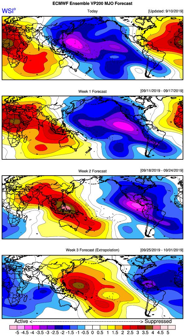
Conditions for development are favorable, with many talking about the MJO entering phases 7-8 allowing for eastern progression of a Kelvin Wave.


_________________
_______________________________________________________________________________________________________
CLICK HERE to view NJ Strong Snowstorm Classifications
 Re: 2019 TROPICAL SEASON
Today's EURO, GFS, and CMC all show a strong cane in the Bahamas with a sharp trough setting up along the east coast.

nutleyblizzard- Senior Enthusiast

- Posts : 1954
Reputation : 41
Join date : 2014-01-30
Age : 58
Location : Nutley, new jersey
 Re: 2019 TROPICAL SEASON
Cap gonna come off the tropics as head past the 20th time frame peeps MJO looking to go into phase which is conducive for trop cyclone activity.
Bahamas, Gulf Coast and East Coast need to watch from this time through mid October.
JMAN my condolences on your loss
Bahamas, Gulf Coast and East Coast need to watch from this time through mid October.
JMAN my condolences on your loss
_________________
Mugs
AKA:King: Snow Weenie
Self Proclaimed
WINTER 2014-15 : 55.12" +.02 for 6 coatings (avg. 35")
WINTER 2015-16 Total - 29.8" (Avg 35")
WINTER 2016-17 : 39.5" so far

amugs- Advanced Forecaster - Mod

- Posts : 15095
Reputation : 213
Join date : 2013-01-07
Age : 54
Location : Hillsdale,NJ
 Re: 2019 TROPICAL SEASON
WOW at tonight's Euro I know it's still seven eight days out but that's not the spot you want to see it make landfall here jman sorry for your loss my condolences

algae888- Advanced Forecaster

- Posts : 5311
Reputation : 46
Join date : 2013-02-05
Age : 62
Location : mt. vernon, new york
 Re: 2019 TROPICAL SEASON
Interesting EURO run that it now takes the 1st system and develops it east of Florida and up the coast. 6z hurricanes models with a big shift east as well


Sanchize06- Senior Enthusiast

- Posts : 1041
Reputation : 21
Join date : 2013-02-05
Location : Union Beach, NJ

skinsfan1177- Senior Enthusiast

- Posts : 4485
Reputation : 35
Join date : 2013-01-07
Age : 46
Location : Point Pleasant Boro
 Re: 2019 TROPICAL SEASON
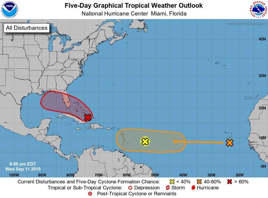
Yeah interesting the 00z euro takes the red area up the coast and landfall as a cat 1 or 2 can't around nj NYC and another one in its footsteps!! We are within 10 days according euro. Gfs does not show this. The first storm actually takes a retrograde back at us as it looked like it was going ots at first.

jmanley32- Senior Enthusiast

- Posts : 20535
Reputation : 108
Join date : 2013-12-12
Age : 43
Location : Yonkers, NY
 Re: 2019 TROPICAL SEASON
jman sorry for your loss,i'm still going through my loss from last year,so i know the pain,anyway being in the site takes my mind off things and try to keep busy..prayers up for u and the family...stay strong...
mwilli- Posts : 132
Reputation : 3
Join date : 2019-02-11
 Re: 2019 TROPICAL SEASON
Hi guys (and gals)!
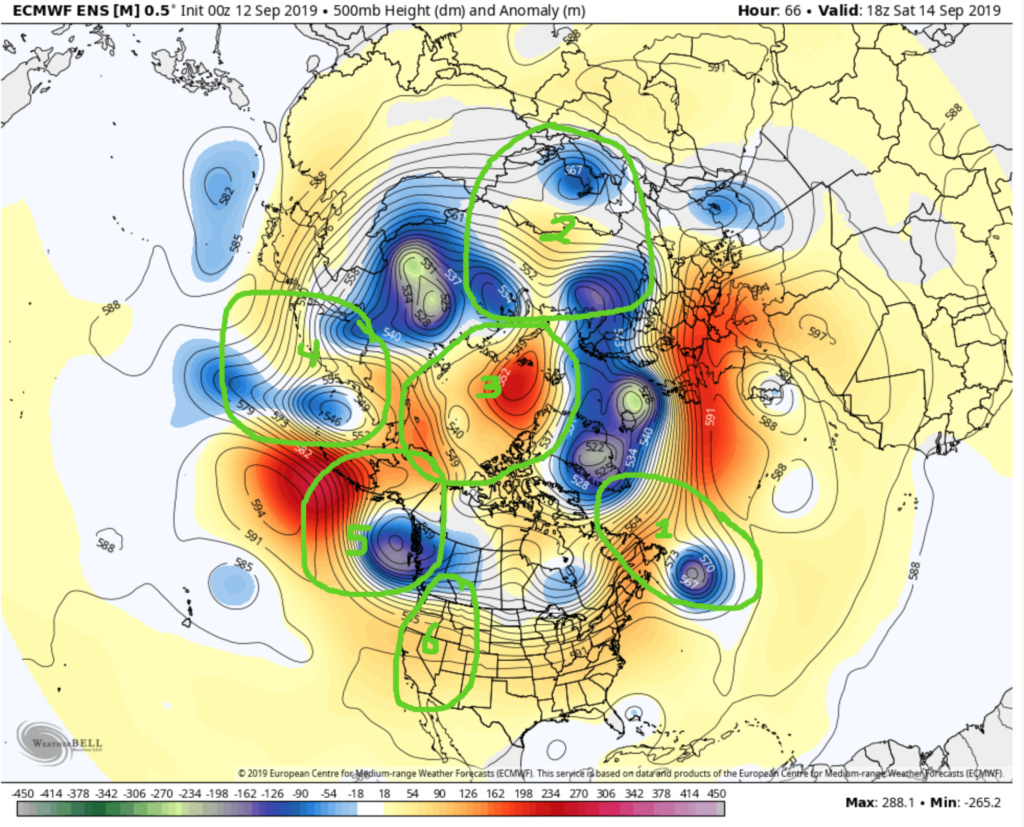
As promised, I just wanted to provide some more detailed thoughts regarding our two potential systems of interest, 95L, as well as the Invest area west of the Cape Verde Islands. For reference, please note that this analysis is entirely subjective, uses a rough 1:1 weighting mechanism when assessing overall impact of various factors, and was performed using all 00z data. This discussion will be utilizing mainly H5 anomaly graphics from WeatherBell’s EURO Ensemble (I like their more vivid/sensitive color scheme; though other maps including SST anomalies, a line chart for Niño Region 1.2, and a surface pressure anomaly map will also be included. However, please note that my thinking does not solely reflect what is depicted in the EURO Ensemble graphics.
To start off, I DO NOT think that 95L will be a substantial threat to the U.S., and will end up taking a similar track, albeit on a much weaker scale, to Dorian. Here’s why. Beginning with the H5 anomaly map, there are six areas that I would like to draw your attention to at 14th/18z, keeping in mind that warmer colors denote positive height anomalies (higher than average heights, stronger than average ridging), cooler colors denote negative height anomalies (lower than average heights, stronger than average troughing), and the mean heights are contoured with black lines:
1. Pseudo –N.A.O., which will help to shorten the wavelengths across East-central North America and enhance troughing.
2. 70/70 region – for the purpose of this analysis, this was treated as a “neutral” signal, and therefore has no effect.
3. –A.O. – this helps to allow troughs to be enhanced as they propagate acorss North America.
4. W.P.O. region – for the purpose of this analysis, this was treated as a “neutral” signal, and therefore has no effect.
5. –E.P.O./digging trough off Pacific Northwest – this tandem helps to allow troughs to be enhanced as they propagate across North America.
6. P.N.A. region – for the purpose of this analysis, this was treated as a “neutral” signal, and therefore has no effect.
There are also other components:
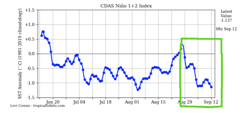
7. The recent rapid fall of Niño Region 1.2 SST anomalies – at a lead time of two to three weeks, this correlates to the enhancement of troughing as it propagates across North America.
8. The M.J.O. was treated as being in a “neutral”/suppressed state for the purpose of this analysis, and therefore has no effect.
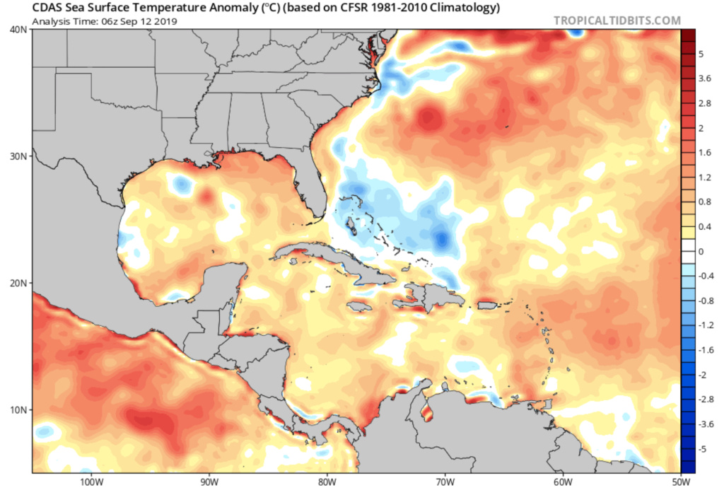
9. Anomalously warm Atlantic and Gulf Waters, which work to enhance ridging via latent heat feedback. However, note the “shadow” of cooler water upwelled by Dorian. This should play a role in preventing steady strengthening of 95L.
10. –S.O.I. – this correlates to the enhancement of troughs as they propagate across North America.
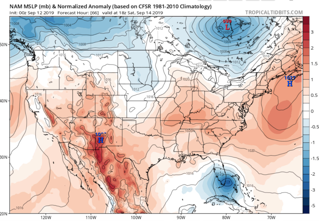
11. Surface pressure anomalies (note, while similar to the EURO Ensemble H5 map, I used the 00z NAM, as I like its overall progression the best regarding the pressure anomalies surrounding 95L. Do not agree with its track – I feel that it is too suppressed). I do think this will be conducive to early strengthening, though that will level off for reasons to be discussed.
12. Similar to Dorian, the historical observations that storms coming from the southeast of Florida have a very hard time landfalling along the east coast north of about West Palm Beach due to meso-scale dynamical processes.
The reason I chose this frame is because I think we have generally good agreement amongst the various suites regarding the timing and placement of 95L: It’s what happens after this where models diverge. I also chose this frame because in my opinion, it is a pivotal time in the evolution of the pattern and system itself. Based on all of the factors above, here is what I believe:
1. 95L WILL strengthen, probably to a tropical storm based on:
a. anomalously high pressure to its north and northeast enhancing lower-level convergence as the system propagates to the northwest
b. presence of relatively warm water
c. overall relatively favorable atmospheric environment
d. decreasing proximity to a cyclonically curved coastline
2. 95L MAY reach a weak Category 1, though I think overall development will be limited by:
a. shadow of cooler water left by Dorian as 95L develops/moves generally northwestward
b. decreasing positive pressure anomalies as the system moves northwestward, discussed next
3. Based on factors (1-) through (9):
a. The energy/trough progged to be propagating across North America during this frame, as well as subsequent frames, should end up having notably more strength than is currently modeled by the EURO and GEM Ensembles, and a little more than currently advertised by the GFS Ensembles. Overall, I like the look of the GFS Ensemble H5 evolution, though still think that some additional correction toward a stronger trough occurs.
b. The above will work to:
i. Start mitigating the positive pressure anomalies over the top of 95L as a surface low and associated cold front start progressing eastward, thereby lowering the pressures out ahead of it and 95L.
ii. The surface low/associated cold front/associated mid- and upper-level trough should be able decrease latitude more than currently modeled, which will begin imparting more of a westerly component to the steering flow simultaneously with 95L’s movement.
c. From completely anecdotal experience, climatology is also a hard thing to bet against, which is evident in (11).
Based on my analysis, all of the effects above combined with (11) and (12) should allow 95L to parallel the Southeast Coast as a tropical storm or minimal Category 1, with either no direct U.S. landfall or another North Carolina landfall before heading out to sea. I am not expecting any significant impacts up here.
As promised, I just wanted to provide some more detailed thoughts regarding our two potential systems of interest, 95L, as well as the Invest area west of the Cape Verde Islands. For reference, please note that this analysis is entirely subjective, uses a rough 1:1 weighting mechanism when assessing overall impact of various factors, and was performed using all 00z data. This discussion will be utilizing mainly H5 anomaly graphics from WeatherBell’s EURO Ensemble (I like their more vivid/sensitive color scheme; though other maps including SST anomalies, a line chart for Niño Region 1.2, and a surface pressure anomaly map will also be included. However, please note that my thinking does not solely reflect what is depicted in the EURO Ensemble graphics.
To start off, I DO NOT think that 95L will be a substantial threat to the U.S., and will end up taking a similar track, albeit on a much weaker scale, to Dorian. Here’s why. Beginning with the H5 anomaly map, there are six areas that I would like to draw your attention to at 14th/18z, keeping in mind that warmer colors denote positive height anomalies (higher than average heights, stronger than average ridging), cooler colors denote negative height anomalies (lower than average heights, stronger than average troughing), and the mean heights are contoured with black lines:
1. Pseudo –N.A.O., which will help to shorten the wavelengths across East-central North America and enhance troughing.
2. 70/70 region – for the purpose of this analysis, this was treated as a “neutral” signal, and therefore has no effect.
3. –A.O. – this helps to allow troughs to be enhanced as they propagate acorss North America.
4. W.P.O. region – for the purpose of this analysis, this was treated as a “neutral” signal, and therefore has no effect.
5. –E.P.O./digging trough off Pacific Northwest – this tandem helps to allow troughs to be enhanced as they propagate across North America.
6. P.N.A. region – for the purpose of this analysis, this was treated as a “neutral” signal, and therefore has no effect.

There are also other components:
7. The recent rapid fall of Niño Region 1.2 SST anomalies – at a lead time of two to three weeks, this correlates to the enhancement of troughing as it propagates across North America.

8. The M.J.O. was treated as being in a “neutral”/suppressed state for the purpose of this analysis, and therefore has no effect.
9. Anomalously warm Atlantic and Gulf Waters, which work to enhance ridging via latent heat feedback. However, note the “shadow” of cooler water upwelled by Dorian. This should play a role in preventing steady strengthening of 95L.

10. –S.O.I. – this correlates to the enhancement of troughs as they propagate across North America.
11. Surface pressure anomalies (note, while similar to the EURO Ensemble H5 map, I used the 00z NAM, as I like its overall progression the best regarding the pressure anomalies surrounding 95L. Do not agree with its track – I feel that it is too suppressed). I do think this will be conducive to early strengthening, though that will level off for reasons to be discussed.

12. Similar to Dorian, the historical observations that storms coming from the southeast of Florida have a very hard time landfalling along the east coast north of about West Palm Beach due to meso-scale dynamical processes.
The reason I chose this frame is because I think we have generally good agreement amongst the various suites regarding the timing and placement of 95L: It’s what happens after this where models diverge. I also chose this frame because in my opinion, it is a pivotal time in the evolution of the pattern and system itself. Based on all of the factors above, here is what I believe:
1. 95L WILL strengthen, probably to a tropical storm based on:
a. anomalously high pressure to its north and northeast enhancing lower-level convergence as the system propagates to the northwest
b. presence of relatively warm water
c. overall relatively favorable atmospheric environment
d. decreasing proximity to a cyclonically curved coastline
2. 95L MAY reach a weak Category 1, though I think overall development will be limited by:
a. shadow of cooler water left by Dorian as 95L develops/moves generally northwestward
b. decreasing positive pressure anomalies as the system moves northwestward, discussed next
3. Based on factors (1-) through (9):
a. The energy/trough progged to be propagating across North America during this frame, as well as subsequent frames, should end up having notably more strength than is currently modeled by the EURO and GEM Ensembles, and a little more than currently advertised by the GFS Ensembles. Overall, I like the look of the GFS Ensemble H5 evolution, though still think that some additional correction toward a stronger trough occurs.
b. The above will work to:
i. Start mitigating the positive pressure anomalies over the top of 95L as a surface low and associated cold front start progressing eastward, thereby lowering the pressures out ahead of it and 95L.
ii. The surface low/associated cold front/associated mid- and upper-level trough should be able decrease latitude more than currently modeled, which will begin imparting more of a westerly component to the steering flow simultaneously with 95L’s movement.
c. From completely anecdotal experience, climatology is also a hard thing to bet against, which is evident in (11).
Based on my analysis, all of the effects above combined with (11) and (12) should allow 95L to parallel the Southeast Coast as a tropical storm or minimal Category 1, with either no direct U.S. landfall or another North Carolina landfall before heading out to sea. I am not expecting any significant impacts up here.
rb924119- Meteorologist

- Posts : 6928
Reputation : 194
Join date : 2013-02-06
Age : 32
Location : Greentown, Pa
 Re: 2019 TROPICAL SEASON
Well that's no fun oh well won't be interested in next 2 weeks I guess. At least my funeral trip to Florida on 18th will be fine.

jmanley32- Senior Enthusiast

- Posts : 20535
Reputation : 108
Join date : 2013-12-12
Age : 43
Location : Yonkers, NY
 Re: 2019 TROPICAL SEASON
12z ICON similar to EURO, coming up the coast at hr 180, but that's as far as the run goes out to
Sanchize06- Senior Enthusiast

- Posts : 1041
Reputation : 21
Join date : 2013-02-05
Location : Union Beach, NJ
 Re: 2019 TROPICAL SEASON
jmanley32 wrote:Well that's no fun oh well won't be interested in next 2 weeks I guess. At least my funeral trip to Florida on 18th will be fine.
Can’t EVER write these things off lol a seasoned veteran such as yourself should know better lmao
rb924119- Meteorologist

- Posts : 6928
Reputation : 194
Join date : 2013-02-06
Age : 32
Location : Greentown, Pa
 Re: 2019 TROPICAL SEASON
Everything is on the table

skinsfan1177- Senior Enthusiast

- Posts : 4485
Reputation : 35
Join date : 2013-01-07
Age : 46
Location : Point Pleasant Boro
 Re: 2019 TROPICAL SEASON
I know but you were right before and I'm looking for something to do to get my mind off what's going on here. Very tired stressed. I should written that in banter.rb924119 wrote:jmanley32 wrote:Well that's no fun oh well won't be interested in next 2 weeks I guess. At least my funeral trip to Florida on 18th will be fine.
Can’t EVER write these things off lol a seasoned veteran such as yourself should know better lmao

jmanley32- Senior Enthusiast

- Posts : 20535
Reputation : 108
Join date : 2013-12-12
Age : 43
Location : Yonkers, NY
 Re: 2019 TROPICAL SEASON
which system the one closest to the U.S. now or the one about 2 weeks away? I'm surprised models are show the supposed gom system going up coast. Just needs happen after 19th if it does in Florida burial is 18th.Sanchize06 wrote:12z ICON similar to EURO, coming up the coast at hr 180, but that's as far as the run goes out to

jmanley32- Senior Enthusiast

- Posts : 20535
Reputation : 108
Join date : 2013-12-12
Age : 43
Location : Yonkers, NY
 Re: 2019 TROPICAL SEASON
jmanley32 wrote:which system the one closest to the U.S. now or the one about 2 weeks away? I'm surprised models are show the supposed gom system going up coast. Just needs happen after 19th if it does in Florida burial is 18th.Sanchize06 wrote:12z ICON similar to EURO, coming up the coast at hr 180, but that's as far as the run goes out to
The closest one near the Bahamas now. That's another important thing about watching this system closely. Usually we're tracking tropical systems for 10-14 days, but this is only 7-8 days out or so.
Sanchize06- Senior Enthusiast

- Posts : 1041
Reputation : 21
Join date : 2013-02-05
Location : Union Beach, NJ
 Re: 2019 TROPICAL SEASON
jmanley32 wrote:I know but you were right before and I'm looking for something to do to get my mind off what's going on here. Very tired stressed. I should written that in banter.rb924119 wrote:jmanley32 wrote:Well that's no fun oh well won't be interested in next 2 weeks I guess. At least my funeral trip to Florida on 18th will be fine.
Can’t EVER write these things off lol a seasoned veteran such as yourself should know better lmao
That doesn’t mean anything aha the weather doesn’t care about statistics or previous forecasts. It does what it does best - continues to be unpredictable lmao
rb924119- Meteorologist

- Posts : 6928
Reputation : 194
Join date : 2013-02-06
Age : 32
Location : Greentown, Pa
 Re: 2019 TROPICAL SEASON
Gfs has nothing now through 23rd. I know windshield wiper but it has always shown something now nothing.

jmanley32- Senior Enthusiast

- Posts : 20535
Reputation : 108
Join date : 2013-12-12
Age : 43
Location : Yonkers, NY
 Re: 2019 TROPICAL SEASON
jmanley32 wrote:Gfs has nothing now through 23rd. I know windshield wiper but it has always shown something now nothing.
This is also the time frame where models lose systems, then bring them back inside six to eight days. Patience, young pattawan lmao I’m honestly more concerned with the second potential system than 95L, but I have to do further analysis on that.
rb924119- Meteorologist

- Posts : 6928
Reputation : 194
Join date : 2013-02-06
Age : 32
Location : Greentown, Pa
 Re: 2019 TROPICAL SEASON
Yes very true. I wish I was your age again lol. I see nhc moved the red zone much further east and into western Atlantic now hmmm.

jmanley32- Senior Enthusiast

- Posts : 20535
Reputation : 108
Join date : 2013-12-12
Age : 43
Location : Yonkers, NY
Page 15 of 17 •  1 ... 9 ... 14, 15, 16, 17
Page 15 of 17
Permissions in this forum:
You cannot reply to topics in this forum|
|
|

 Home
Home
