
 Search
2019 TROPICAL SEASON
Page 3 of 17 •  1, 2, 3, 4 ... 10 ... 17
 ![]()
Re: 2019 TROPICAL SEASON
![]() by jmanley32 Sun Aug 25, 2019 2:22 pm
by jmanley32 Sun Aug 25, 2019 2:22 pm
as progged it's supposed to go over Hispaniola as a ts and come 9ff as a depression. That Island is death for hurricanes but once it moves into Bahamas could regenerate quickly. Any movement to the south or north thpugh and a miss to That Island could mean a much stronger storm. And I'm assuming Bill means Monday as in Sept. 2nd.billg315 wrote:I would agree the disturbance off Florida probably limps OTS even if it does intensify. Dorian is wide open to possibilities now since it’s so far out. Does look to become a hurricane. IF it were to impact the Gulf or East Coast the most likely time-frame would be Saturday to Monday, so it bears watching. Too earlier to know anything for sure though.
jmanley32- Senior Enthusiast

- Posts : 20535
Join date : 2013-12-12

skinsfan1177- Senior Enthusiast
- Posts : 4485
Join date : 2013-01-07
Re: 2019 TROPICAL SEASON
![]() by jmanley32 Mon Aug 26, 2019 2:08 pm
by jmanley32 Mon Aug 26, 2019 2:08 pm

jmanley32- Senior Enthusiast
- Posts : 20535
Reputation : 108
Join date : 2013-12-12
Age : 43
Location : Yonkers, NY
Re: 2019 TROPICAL SEASON
![]() by skinsfan1177 Mon Aug 26, 2019 5:16 pm
by skinsfan1177 Mon Aug 26, 2019 5:16 pm


skinsfan1177- Senior Enthusiast
- Posts : 4485
Reputation : 35
Join date : 2013-01-07
Age : 46
Location : Point Pleasant Boro
Re: 2019 TROPICAL SEASON
![]() by jmanley32 Tue Aug 27, 2019 10:10 am
by jmanley32 Tue Aug 27, 2019 10:10 am
jmanley32- Senior Enthusiast
- Posts : 20535
Reputation : 108
Join date : 2013-12-12
Age : 43
Location : Yonkers, NY
Re: 2019 TROPICAL SEASON
![]() by skinsfan1177 Tue Aug 27, 2019 10:45 am
by skinsfan1177 Tue Aug 27, 2019 10:45 am
jmanley32 wrote:Current track has Dorian missing the majority of hispanola and taking a sneak between which is pretty rare but other things seem to stop him from gaining strength in the Bahamas before a possible landfall on Florida east coast Friday or Saturday. I find it hard to believe with the Bahamas area being a usually primo area that he doesn't gain some strength. We shall see.
Its not looking to Goid jman recon went through
skinsfan1177- Senior Enthusiast
- Posts : 4485
Reputation : 35
Join date : 2013-01-07
Age : 46
Location : Point Pleasant Boro
Re: 2019 TROPICAL SEASON
![]() by jmanley32 Tue Aug 27, 2019 1:31 pm
by jmanley32 Tue Aug 27, 2019 1:31 pm
skinsfan1177 wrote:jmanley32 wrote:Current track has Dorian missing the majority of hispanola and taking a sneak between which is pretty rare but other things seem to stop him from gaining strength in the Bahamas before a possible landfall on Florida east coast Friday or Saturday. I find it hard to believe with the Bahamas area being a usually primo area that he doesn't gain some strength. We shall see.
Its not looking to Goid jman recon went through
ahh ok well whatever. I guess it is good for people down there. There will be more to track.
jmanley32- Senior Enthusiast
- Posts : 20535
Reputation : 108
Join date : 2013-12-12
Age : 43
Location : Yonkers, NY
Re: 2019 TROPICAL SEASON
![]() by sroc4 Tue Aug 27, 2019 7:42 pm
by sroc4 Tue Aug 27, 2019 7:42 pm
jmanley32 wrote:skinsfan1177 wrote:jmanley32 wrote:Current track has Dorian missing the majority of hispanola and taking a sneak between which is pretty rare but other things seem to stop him from gaining strength in the Bahamas before a possible landfall on Florida east coast Friday or Saturday. I find it hard to believe with the Bahamas area being a usually primo area that he doesn't gain some strength. We shall see.
Its not looking to Goid jman recon went through
ahh ok well whatever. I guess it is good for people down there. There will be more to track.
Dont give up on it yet. Way too many variables. Currently there is a fair amount of shear on its NW flank in the direction its headed.

Second there is dry air in the midlevels(700mb-500mb approx) on both the NNE and SSE periphery. The system is ingesting this dry air and is wreaking havoc on the convection. You can see it on the dropsonde recon data and on the sat imagery. Watch the convection in these areas just fizzle on the sat loop below.

That said if it survives as it passes between PR and Hispanola somewhat of an anticyclone is forecasted to develop over top and an ULL to its SE that could enhance ventilation with gradual strengthening is possible. As it approaches the Bahamas it will be in a much more saturated air mass and much less dry air. As it approaches the SE CONUS late week there is a positively tilted trough approaching the NE coast line around the smae time and hints of a possible jet streak forecasted. IF th timing were right it would put Dorian in the right rear quadrant which enhances upward motion and could cause additional strengthening. This one is not done by a long shot. Still way to many variables to stick a fork in this. Alot can happen for better or worse....thats right Jon.....
WE TRACK!!

_________________
"In weather and in life, there's no winning and losing; there's only winning and learning."
WINTER 2012/2013 TOTALS 43.65"WINTER 2017/2018 TOTALS 62.85" WINTER 2022/2023 TOTALS 4.9"
WINTER 2013/2014 TOTALS 64.85"WINTER 2018/2019 TOTALS 14.25" WINTER 2023/2024 TOTALS 13.1"
WINTER 2014/2015 TOTALS 71.20"WINTER 2019/2020 TOTALS 6.35"
WINTER 2015/2016 TOTALS 35.00"WINTER 2020/2021 TOTALS 37.75"
WINTER 2016/2017 TOTALS 42.25"WINTER 2021/2022 TOTALS 31.65"

sroc4- Admin

- Posts : 8354
Reputation : 302
Join date : 2013-01-07
Location : Wading River, LI
Re: 2019 TROPICAL SEASON
![]() by SoulSingMG Tue Aug 27, 2019 10:36 pm
by SoulSingMG Tue Aug 27, 2019 10:36 pm

SoulSingMG- Senior Enthusiast
- Posts : 2853
Reputation : 74
Join date : 2013-12-11
Location : Long Island City, NY

SoulSingMG- Senior Enthusiast
- Posts : 2853
Reputation : 74
Join date : 2013-12-11
Location : Long Island City, NY

SoulSingMG- Senior Enthusiast
- Posts : 2853
Reputation : 74
Join date : 2013-12-11
Location : Long Island City, NY
Re: 2019 TROPICAL SEASON
![]() by SoulSingMG Wed Aug 28, 2019 1:17 am
by SoulSingMG Wed Aug 28, 2019 1:17 am
SoulSingMG wrote:...and then this happened.
Beyond that, it curves back OTS off Hatteras. Case in point, lots of uncertainty for at least the next 48 hours.
SoulSingMG- Senior Enthusiast
- Posts : 2853
Reputation : 74
Join date : 2013-12-11
Location : Long Island City, NY
Re: 2019 TROPICAL SEASON
![]() by jmanley32 Wed Aug 28, 2019 3:25 am
by jmanley32 Wed Aug 28, 2019 3:25 am
jmanley32- Senior Enthusiast
- Posts : 20535
Reputation : 108
Join date : 2013-12-12
Age : 43
Location : Yonkers, NY

skinsfan1177- Senior Enthusiast
- Posts : 4485
Reputation : 35
Join date : 2013-01-07
Age : 46
Location : Point Pleasant Boro
Re: 2019 TROPICAL SEASON
![]() by jmanley32 Wed Aug 28, 2019 7:33 am
by jmanley32 Wed Aug 28, 2019 7:33 am
jmanley32- Senior Enthusiast
- Posts : 20535
Reputation : 108
Join date : 2013-12-12
Age : 43
Location : Yonkers, NY
Re: 2019 TROPICAL SEASON
![]() by skinsfan1177 Wed Aug 28, 2019 7:49 am
by skinsfan1177 Wed Aug 28, 2019 7:49 am
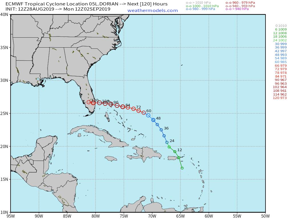
jmanley32 wrote:Wow gfs has it down to 959mb cat 4 off SC...i was sure he was going to interact with Hispaniola but he took the smarter course for his life...maybe not so for those on the ec though.
Correct Jay man it's not going to interact with hhispinola it took more of a North jog. Models are showing as high as a cat too and it should be starting to get its act together soon hurricane watches are up for Puerto Rico
skinsfan1177- Senior Enthusiast
- Posts : 4485
Reputation : 35
Join date : 2013-01-07
Age : 46
Location : Point Pleasant Boro
Re: 2019 TROPICAL SEASON
![]() by skinsfan1177 Wed Aug 28, 2019 8:19 am
by skinsfan1177 Wed Aug 28, 2019 8:19 am
skinsfan1177- Senior Enthusiast
- Posts : 4485
Reputation : 35
Join date : 2013-01-07
Age : 46
Location : Point Pleasant Boro
Re: 2019 TROPICAL SEASON
![]() by jmanley32 Wed Aug 28, 2019 11:15 am
by jmanley32 Wed Aug 28, 2019 11:15 am
jmanley32- Senior Enthusiast
- Posts : 20535
Reputation : 108
Join date : 2013-12-12
Age : 43
Location : Yonkers, NY
Re: 2019 TROPICAL SEASON
![]() by nutleyblizzard Wed Aug 28, 2019 1:53 pm
by nutleyblizzard Wed Aug 28, 2019 1:53 pm

nutleyblizzard- Senior Enthusiast
- Posts : 1954
Reputation : 41
Join date : 2014-01-30
Age : 58
Location : Nutley, new jersey
Re: 2019 TROPICAL SEASON
![]() by amugs Wed Aug 28, 2019 3:10 pm
by amugs Wed Aug 28, 2019 3:10 pm
Latest Euro and GFS are very concerning for the FLA coast and SE as well as the North Gulf Coast - it would be an absolute disaster if she slams S FLA and then tracks into the Panhandle where Mikey did last year.
She is blossoming - look at the convection burst
_________________
Mugs
AKA:King: Snow Weenie
Self Proclaimed
WINTER 2014-15 : 55.12" +.02 for 6 coatings (avg. 35")
WINTER 2015-16 Total - 29.8" (Avg 35")
WINTER 2016-17 : 39.5" so far

amugs- Advanced Forecaster - Mod

- Posts : 15095
Reputation : 213
Join date : 2013-01-07
Age : 54
Location : Hillsdale,NJ
Re: 2019 TROPICAL SEASON
![]() by amugs Wed Aug 28, 2019 3:12 pm
by amugs Wed Aug 28, 2019 3:12 pm

_________________
Mugs
AKA:King: Snow Weenie
Self Proclaimed
WINTER 2014-15 : 55.12" +.02 for 6 coatings (avg. 35")
WINTER 2015-16 Total - 29.8" (Avg 35")
WINTER 2016-17 : 39.5" so far
amugs- Advanced Forecaster - Mod
- Posts : 15095
Reputation : 213
Join date : 2013-01-07
Age : 54
Location : Hillsdale,NJ

dkodgis- Senior Enthusiast
- Posts : 2560
Reputation : 98
Join date : 2013-12-29
Re: 2019 TROPICAL SEASON
![]() by GreyBeard Wed Aug 28, 2019 5:51 pm
by GreyBeard Wed Aug 28, 2019 5:51 pm
amugs wrote:
Hoping it doesn't pan out like this. Have too many family members right inside that bullseye zone. My son just moved into a new apartment in Fort Lauderdale 3 days ago.

GreyBeard- Senior Enthusiast
- Posts : 725
Reputation : 34
Join date : 2014-02-12
Location : eastern nassau county
Re: 2019 TROPICAL SEASON
![]() by amugs Wed Aug 28, 2019 6:12 pm
by amugs Wed Aug 28, 2019 6:12 pm
_________________
Mugs
AKA:King: Snow Weenie
Self Proclaimed
WINTER 2014-15 : 55.12" +.02 for 6 coatings (avg. 35")
WINTER 2015-16 Total - 29.8" (Avg 35")
WINTER 2016-17 : 39.5" so far
amugs- Advanced Forecaster - Mod
- Posts : 15095
Reputation : 213
Join date : 2013-01-07
Age : 54
Location : Hillsdale,NJ
Re: 2019 TROPICAL SEASON
![]() by jmanley32 Wed Aug 28, 2019 6:25 pm
by jmanley32 Wed Aug 28, 2019 6:25 pm
jmanley32- Senior Enthusiast
- Posts : 20535
Reputation : 108
Join date : 2013-12-12
Age : 43
Location : Yonkers, NY
Re: 2019 TROPICAL SEASON
![]() by rb924119 Thu Aug 29, 2019 12:08 am
by rb924119 Thu Aug 29, 2019 12:08 am
Not that many/any of you really care to hear, but I’m currently on vacation with highly limited internet access (mobile only), so the ability to really sit and comfortably analyze anything in detail is quite restricted.....cell phone screens are too small for this field hahaha anyway, I quickly skimmed through the pages in the thread and would like to offer some additional opinion. I believe that not enough attention is being paid to the trough progged to be progressing through the U.S. simultaneously with Dorian’s westward motion and possible strengthening. Based on my (subjective) analysis, this trough should wind up a bit stronger/deeper and faster with its progression compared with current modeling. At face value, this would be a good thing, as I think the likelihood of interaction would be greatly increased and a sweep out to sea much more likely, especially when considering the historical tendency for storms coming from this general direction (southeast of Florida) to not “want” to landfall along the eastern coast of Florida where the coastline is not due north-south. However, Dorian’s rate of intensification has a direct impact on whether a connection with this trough (hypothetically) occurs, as the faster intensitification occurs, the slower storms tend to move (as evidenced by the bimodally distributed EPS members posted earlier).
As we know, intensity forecasts are very uncertain when it comes to these systems, but given what we have seen so far, it appears to be overachieving. That said, it is also running along the northwestern flank of large-scale subsidence per 200hPa CHI charts which could work to mitigate overall strengthening down the road (i.e. acting as a capping mechanism with regard to intensity as this larger-scale subsidence partislly offsets smaller-scale factors).
Other factors already mentioned include the effects of diabatic and latent heat release feedbacks, in addition to the Northern Hemispheric alignment, climatology, and meso-scale evolutions near land, and based on what I’m currently seeing, I think a last-minute turn to the north along/just offshore of Florida’s east coast is more likely than not, with an eventual turn out sea off the Carolinas. I wish I could elaborate further with images and stuff, but I can only do so much on mobile. Just my two cents, and obviously open for discussion
rb924119- Meteorologist

- Posts : 6928
Reputation : 194
Join date : 2013-02-06
Age : 32
Location : Greentown, Pa
Re: 2019 TROPICAL SEASON
![]() by jmanley32 Thu Aug 29, 2019 6:35 am
by jmanley32 Thu Aug 29, 2019 6:35 am
jmanley32- Senior Enthusiast
- Posts : 20535
Reputation : 108
Join date : 2013-12-12
Age : 43
Location : Yonkers, NY
Page 3 of 17 • 1, 2, 3, 4 ... 10 ... 17 ![]()
|
|
|