
 Search
December 1st-3rd 2019 Winter Storm Potential
Page 1 of 8 • 1, 2, 3, 4, 5, 6, 7, 8 ![]()

December 1st-3rd 2019 Winter Storm Potential
![]() by sroc4 Tue Nov 26, 2019 10:01 am
by sroc4 Tue Nov 26, 2019 10:01 am
So again this thread will highlight the big picture only. Here goes:
Within about 24 hours this is what the 500mb configuration will look like.


What we have is a stout -NAO ridge over Greenland(blocking ridge), a -PNA(trough) along the west coast(WC), and a N Pacific ridge centered south of Alaska, and west of the WC of Canada. The mid week system, that will bring the gusty winds for Thanksgiving, will form as a result of a piece of the energy from the WC trough spinning up into an upper level low (ULL). This ULL will cut and track well up into the GL before it takes a brief turn S&E and passes off the NE coast line. This track of course leads to our area in the warm sector of the surface low and therefore precip is mostly wet; perhpaps some sloppy mix and wet snow changes over well to the N&W. Look again above. Its because of the ridge axis being centered where it is that allows the ULL to cut as far north and west as it does; however, its the -NAO ridge to our NE that actually prevents it from tracking even further N. The N Atlantic blocking actually is what shifts it track back to the S&E. Hopefully the giff above is woking so you can follow the mid week ULL and see its track as it exits the NE coast. NOTE: when an ULL tracks to our N its almost a lock that most of our area is on the warm side of a system. This will be a key point when we discuss the early week potential below.
Let's shift gears now. Below is the 500mb configuration by late Wed eve. As you can see the ULL is in the upper GL and is about to be shunted a little S&E from here.
But pay attention to how the Ridge trough configuration is developing out west. This configuration is termed a Rex Block where you have 500mb HP Ridge north of 500mb LP trough to the south(Ridge over Trough) along the west coast. Notice now that the N Pac ridge, which was S of Alaska over open water is now shifting east; nosing into the WC of Canada. This is vital as you will see.

As you can see below by 06z Sat(about 2am) the rex block is really established and the ridging continues to build east through Canada. All the while our mid week ULL has taken up position at the 50N lat 50W Long (aka 50/50 low) position which in turn deepens and feeds back on the -NAO ridge to its north leading to its enhancement as we cont through Sat. This leads to cold canadian air filtering in behind the mid week system.

Below now is valid for 21z (5pm Sat eve). The next piece of energy has broken off from the WC trough and ejected N&E; however, this is as far north as it gets on this run due to the rex block over top to the north. As you saw in the mid week storm set up above the higher heights were not there over Canada so the ULL was able to traverse N&E unimpeded until it encountered the N Atlantic blocking (-NAO) where it was shunted S&E.


In this set up however the ULL is shunted S&E and takes a track through the Ohio valley and exits the EC somewhere near central to south NJ on this run. Now notice a few things in the loop above and the static image below.

As the ULL approached the EC the -NAO blocks is breaking down, as is the Rex block. The EPO region is becoming strongly +. The timing of this is important.
The take home:
1) We have to see a track that takes the ULL south of Long Island in order to max the white chances for any of us.
2) If the Rex block breaks down too quickly then it will allow the ULL to gain more latitude over the central CONUS before turning ESE and thus exiting the EC further N. bringing us closer to the warm sector.
3) If the -NAO block breaks down too quickly the same problem as point 2 above can happen.
4) If both the rex block and NAO block break down too quickly then it becomes a full on cutter and no one is white; we torch when the precip arrives (least likely scenario but possible)
Like I said in my summary of the overall pattern last week, I believe a resistance is in the air in the form of a very incoherent MJO signal. Despite the fact that the forcast graphs have it in the COD there is high variability in what is happening dayater day let alone in 6-7 days from now. Of course the N&W peeps have the best chance to cash in here, andd I do believe N&W of I-95 sees accumulation. That said Im not totally out for the coast either. The blocking is there to allow it to happen, but the details of how it all plays out is still in question for me. Overall the GFS and Euro (all euro maps used above) are very similar in the big picture set up I described above with the subtle differences in where the ULL exits the coast and as it does so the GFS has a more neutral to neg tilt where as the Euro is still a more progressive or positive tilt. If you look at the surface maps between the two you'll see the GFS tries to form a deformation band on the NW side of the surface LP associated with the neg tilt to the trough where as the precip shield is more disorganized and scattered on the euro. As a result a difference in snow fall totals and total QPF exists regardless of where it falls. GFS much higher overall vs the lower totals on the euro. These are the details for which we should not be worried about until late in the week.
WE TRACK!!!

Last edited by sroc4 on Tue Nov 26, 2019 9:33 pm; edited 1 time in total
_________________
"In weather and in life, there's no winning and losing; there's only winning and learning."
WINTER 2012/2013 TOTALS 43.65"WINTER 2017/2018 TOTALS 62.85" WINTER 2022/2023 TOTALS 4.9"
WINTER 2013/2014 TOTALS 64.85"WINTER 2018/2019 TOTALS 14.25" WINTER 2023/2024 TOTALS 13.1"
WINTER 2014/2015 TOTALS 71.20"WINTER 2019/2020 TOTALS 6.35"
WINTER 2015/2016 TOTALS 35.00"WINTER 2020/2021 TOTALS 37.75"
WINTER 2016/2017 TOTALS 42.25"WINTER 2021/2022 TOTALS 31.65"

sroc4- Admin

- Posts : 8354
Reputation : 302
Join date : 2013-01-07
Location : Wading River, LI
Re: December 1st-3rd 2019 Winter Storm Potential
![]() by Sanchize06 Tue Nov 26, 2019 11:19 am
by Sanchize06 Tue Nov 26, 2019 11:19 am
Sanchize06- Senior Enthusiast

- Posts : 1041
Reputation : 21
Join date : 2013-02-05
Location : Union Beach, NJ
Re: December 1st-3rd 2019 Winter Storm Potential
![]() by heehaw453 Tue Nov 26, 2019 11:20 am
by heehaw453 Tue Nov 26, 2019 11:20 am
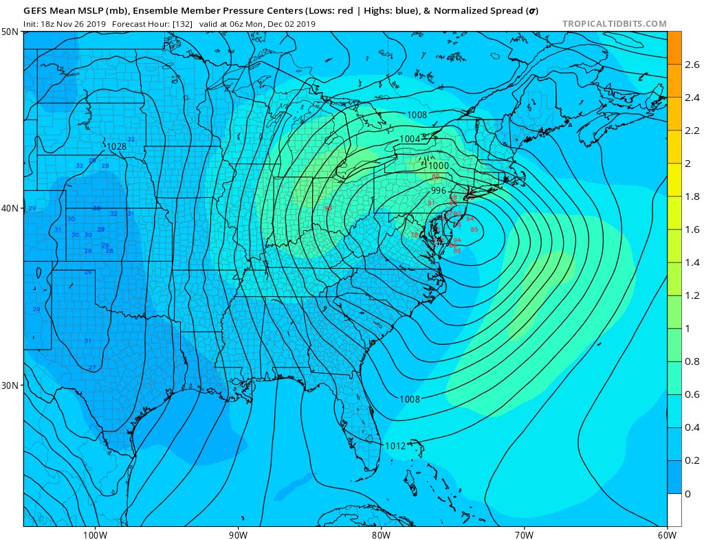
This kind of image gets me optimistic and seeing a lot of model guidance trend towards coastal in this general area. We will have to play the model game for a few more days at least, so expect the usual bad days before we know.

heehaw453- Advanced Forecaster

- Posts : 3906
Reputation : 86
Join date : 2014-01-20
Location : Bedminster Township, PA Elevation 600' ASL
Re: December 1st-3rd 2019 Winter Storm Potential
![]() by jmanley32 Tue Nov 26, 2019 2:57 pm
by jmanley32 Tue Nov 26, 2019 2:57 pm

jmanley32- Senior Enthusiast
- Posts : 20535
Reputation : 108
Join date : 2013-12-12
Age : 43
Location : Yonkers, NY
Re: December 1st-3rd 2019 Winter Storm Potential
![]() by heehaw453 Tue Nov 26, 2019 5:21 pm
by heehaw453 Tue Nov 26, 2019 5:21 pm
heehaw453- Advanced Forecaster
- Posts : 3906
Reputation : 86
Join date : 2014-01-20
Location : Bedminster Township, PA Elevation 600' ASL
Re: December 1st-3rd 2019 Winter Storm Potential
![]() by amugs Tue Nov 26, 2019 5:25 pm
by amugs Tue Nov 26, 2019 5:25 pm
The HH 18Z run.heehaw453 wrote:LOL! 18Z GFS storm sits off the NJ coast for a day caught in the block. That kind of solution would yield monster snow totals.
But not out of the realm with a NAO AND A 50/50 BLOCK. last night Oz had is actually transcend ESE then NW then NE. We have seen some crazy trackers with our storm due to this block which has been underestimated all year long like to WAR.
Time will tell but as Scott said ....WE TRACK!!
_________________
Mugs
AKA:King: Snow Weenie
Self Proclaimed
WINTER 2014-15 : 55.12" +.02 for 6 coatings (avg. 35")
WINTER 2015-16 Total - 29.8" (Avg 35")
WINTER 2016-17 : 39.5" so far

amugs- Advanced Forecaster - Mod

- Posts : 15095
Reputation : 213
Join date : 2013-01-07
Age : 54
Location : Hillsdale,NJ
Re: December 1st-3rd 2019 Winter Storm Potential
![]() by docstox12 Tue Nov 26, 2019 5:25 pm
by docstox12 Tue Nov 26, 2019 5:25 pm

docstox12- Wx Statistician Guru

- Posts : 8530
Reputation : 222
Join date : 2013-01-07
Age : 73
Location : Monroe NY
Re: December 1st-3rd 2019 Winter Storm Potential
![]() by docstox12 Tue Nov 26, 2019 5:27 pm
by docstox12 Tue Nov 26, 2019 5:27 pm
amugs wrote:The HH 18Z run.heehaw453 wrote:LOL! 18Z GFS storm sits off the NJ coast for a day caught in the block. That kind of solution would yield monster snow totals.
But not out of the realm with a NAO AND A 50/50 BLOCK. last night Oz had is actually transcend ESE then NW then NE. We have seen some crazy trackers with our storm due to this block which has been underestimated all year long like to WAR.
Time will tell but as Scott said ....WE TRACK!!
Bring it home Doc and Mugsy! It would be nice to see a significant early December snowstorm.
docstox12- Wx Statistician Guru
- Posts : 8530
Reputation : 222
Join date : 2013-01-07
Age : 73
Location : Monroe NY


SoulSingMG- Senior Enthusiast
- Posts : 2853
Reputation : 74
Join date : 2013-12-11
Location : Long Island City, NY
Re: December 1st-3rd 2019 Winter Storm Potential
![]() by jmanley32 Tue Nov 26, 2019 5:40 pm
by jmanley32 Tue Nov 26, 2019 5:40 pm
yeah, big storm would be a G.... for inland and us coasties may see a few inches, need to get it colder somehow or system slightly more offshore. 850 winds would also make this a B word.SoulSingMG wrote:OOF.
jmanley32- Senior Enthusiast
- Posts : 20535
Reputation : 108
Join date : 2013-12-12
Age : 43
Location : Yonkers, NY
Re: December 1st-3rd 2019 Winter Storm Potential
![]() by nutleyblizzard Tue Nov 26, 2019 6:05 pm
by nutleyblizzard Tue Nov 26, 2019 6:05 pm
Meh. Until the Euro comes on board I'm remaining skeptical.jmanley32 wrote:yeah, big storm would be a G.... for inland and us coasties may see a few inches, need to get it colder somehow or system slightly more offshore. 850 winds would also make this a B word.SoulSingMG wrote:OOF.

nutleyblizzard- Senior Enthusiast
- Posts : 1954
Reputation : 41
Join date : 2014-01-30
Age : 58
Location : Nutley, new jersey
Re: December 1st-3rd 2019 Winter Storm Potential
![]() by skinsfan1177 Tue Nov 26, 2019 6:12 pm
by skinsfan1177 Tue Nov 26, 2019 6:12 pm

skinsfan1177- Senior Enthusiast
- Posts : 4485
Reputation : 35
Join date : 2013-01-07
Age : 46
Location : Point Pleasant Boro
Re: December 1st-3rd 2019 Winter Storm Potential
![]() by hyde345 Tue Nov 26, 2019 7:01 pm
by hyde345 Tue Nov 26, 2019 7:01 pm

hyde345- Pro Enthusiast

- Posts : 1082
Reputation : 48
Join date : 2013-01-08
Location : Hyde Park, NY
Re: December 1st-3rd 2019 Winter Storm Potential
![]() by rb924119 Tue Nov 26, 2019 8:19 pm
by rb924119 Tue Nov 26, 2019 8:19 pm
rb924119- Meteorologist

- Posts : 6928
Reputation : 194
Join date : 2013-02-06
Age : 32
Location : Greentown, Pa
Re: December 1st-3rd 2019 Winter Storm Potential
![]() by amugs Tue Nov 26, 2019 8:27 pm
by amugs Tue Nov 26, 2019 8:27 pm
_________________
Mugs
AKA:King: Snow Weenie
Self Proclaimed
WINTER 2014-15 : 55.12" +.02 for 6 coatings (avg. 35")
WINTER 2015-16 Total - 29.8" (Avg 35")
WINTER 2016-17 : 39.5" so far
amugs- Advanced Forecaster - Mod
- Posts : 15095
Reputation : 213
Join date : 2013-01-07
Age : 54
Location : Hillsdale,NJ
Re: December 1st-3rd 2019 Winter Storm Potential
![]() by jmanley32 Tue Nov 26, 2019 8:41 pm
by jmanley32 Tue Nov 26, 2019 8:41 pm
ok so last time u were wrong so sorry but hope that happens again this time lol. Ur still smart but I oh so want you to be wrong.rb924119 wrote:Personally, I would not set high expectations for this system, folks. I don’t think this system will be much of a winter event based on what I’m seeing, but hey, I’ll still track it!
jmanley32- Senior Enthusiast
- Posts : 20535
Reputation : 108
Join date : 2013-12-12
Age : 43
Location : Yonkers, NY
Re: December 1st-3rd 2019 Winter Storm Potential
![]() by rb924119 Tue Nov 26, 2019 8:55 pm
by rb924119 Tue Nov 26, 2019 8:55 pm
jmanley32 wrote:ok so last time u were wrong so sorry but hope that happens again this time lol. Ur still smart but I oh so want you to be wrong.rb924119 wrote:Personally, I would not set high expectations for this system, folks. I don’t think this system will be much of a winter event based on what I’m seeing, but hey, I’ll still track it!
How was I wrong last time? Lol there were “surprise” snow totals all the way down into Putnam county and into Connecticut. Even NW NJ had some snow out of that. I was never supposed to make it into the city. That said, I never did issue an official forecast so I guess it’s a mute point. But all that said, part of me hopes I’m wrong too, and no hard feelings hahaha :p
rb924119- Meteorologist
- Posts : 6928
Reputation : 194
Join date : 2013-02-06
Age : 32
Location : Greentown, Pa
Re: December 1st-3rd 2019 Winter Storm Potential
![]() by sroc4 Tue Nov 26, 2019 9:18 pm
by sroc4 Tue Nov 26, 2019 9:18 pm
rb924119 wrote:Personally, I would not set high expectations for this system, folks. I don’t think this system will be much of a winter event based on what I’m seeing, but hey, I’ll still track it!
While I think I know where your at, care to elaborate a little?
_________________
"In weather and in life, there's no winning and losing; there's only winning and learning."
WINTER 2012/2013 TOTALS 43.65"WINTER 2017/2018 TOTALS 62.85" WINTER 2022/2023 TOTALS 4.9"
WINTER 2013/2014 TOTALS 64.85"WINTER 2018/2019 TOTALS 14.25" WINTER 2023/2024 TOTALS 13.1"
WINTER 2014/2015 TOTALS 71.20"WINTER 2019/2020 TOTALS 6.35"
WINTER 2015/2016 TOTALS 35.00"WINTER 2020/2021 TOTALS 37.75"
WINTER 2016/2017 TOTALS 42.25"WINTER 2021/2022 TOTALS 31.65"
sroc4- Admin
- Posts : 8354
Reputation : 302
Join date : 2013-01-07
Location : Wading River, LI
Re: December 1st-3rd 2019 Winter Storm Potential
![]() by skinsfan1177 Tue Nov 26, 2019 9:29 pm
by skinsfan1177 Tue Nov 26, 2019 9:29 pm
skinsfan1177- Senior Enthusiast
- Posts : 4485
Reputation : 35
Join date : 2013-01-07
Age : 46
Location : Point Pleasant Boro
Re: December 1st-3rd 2019 Winter Storm Potential
![]() by rb924119 Tue Nov 26, 2019 9:32 pm
by rb924119 Tue Nov 26, 2019 9:32 pm
sroc4 wrote:rb924119 wrote:Personally, I would not set high expectations for this system, folks. I don’t think this system will be much of a winter event based on what I’m seeing, but hey, I’ll still track it!
While I think I know where your at, care to elaborate a little?
Doing this from mobile for a third time is annoying, but because I love you guys, I’ll forward the cliff notes version
The below is a post from Armando’s board in response to if my reason why is because it will be too warm:
“Yes, but that’s only part of it. The trajectory of the system as well as how I expect this trajectory to evolve as a result of the ambient hemispheric synoptics are the others. I have posted more technical discussion over on 33 if you’re there, but basically the evolution of this system is not one that is auspicious for significant winter weather for our area in my opinion. Storms that come from the west are almost always overmodeled in their precipitation fields, only to seemingly disappear as lead time decreases. This is supported when you look at mid-level streamflow, which depicts your “deep” moisture source to be almost exclusively from the Pacific. This then gets downsloped over the Rockies with very little additional moisture flux from the Gulf and Atlantic. Secondarily, this system reaches maturity over the Upper Midwest, and then slowly decays as it continues east-southeastward. So, while it presents itself as a “classic bowling ball” low, in reality, almost all of the dynamics associated with a more classic deepening/maturing cyclone through the column, one that actively is closing off south and/or east of our area, will be non-existent. The mid-levels are not organized enough to support this, and the window of *temporary* reorganization is very small given the progressive nature of the system. Third, when you look at the state of the ambient synoptic atmosphere/ocean couplet, it supports less of a suppressing effect on this system, which makes me think that we end up seeing it pass directly over or even slightly north of our area. This does two things: 1. Prevents us from being in any favorable location for any remaining dynamics to assist in precipitation rates/thermal profiles, as we will get dry slotted. 2. Allow for the stale Pacific air that this system is bringing with it to dominate, as the warm advection out ahead of this would be not be countered. This leads me to additional points that because this system starts so far north/west, the effects of the frontrunning warm advection will be enhanced for us, and without any fresh injection of cold air from a northern stream system, we have no real way to mitigate it in-situ. Secondly, once you get through the initial warm advection surge, conditions will be generally unsettled with showery type precipitation and generally “milder” conditions as the mid- and low-level lows pass overhead.”
I think today’s 12z EURO Op was pretty close in its depiction of sensible effects at the surface, though I fear it could even get a little worse than that by the time it’s over. If you want me to diagnose further, though, let me know, but I think that you can synthesize the details I left out regarding the synoptic hemispheric/oceanic alignments haha
rb924119- Meteorologist
- Posts : 6928
Reputation : 194
Join date : 2013-02-06
Age : 32
Location : Greentown, Pa
Re: December 1st-3rd 2019 Winter Storm Potential
![]() by rb924119 Tue Nov 26, 2019 9:36 pm
by rb924119 Tue Nov 26, 2019 9:36 pm
rb924119- Meteorologist
- Posts : 6928
Reputation : 194
Join date : 2013-02-06
Age : 32
Location : Greentown, Pa
Re: December 1st-3rd 2019 Winter Storm Potential
![]() by jmanley32 Tue Nov 26, 2019 9:38 pm
by jmanley32 Tue Nov 26, 2019 9:38 pm
Wasnt there a system where you said you had egg on your face? I could sworn I saw that which also made me laugh cuz this is not a exact science. And yes you were partially right, no one can get it exact, if they did that would be amazing.rb924119 wrote:jmanley32 wrote:ok so last time u were wrong so sorry but hope that happens again this time lol. Ur still smart but I oh so want you to be wrong.rb924119 wrote:Personally, I would not set high expectations for this system, folks. I don’t think this system will be much of a winter event based on what I’m seeing, but hey, I’ll still track it!
How was I wrong last time? Lol there were “surprise” snow totals all the way down into Putnam county and into Connecticut. Even NW NJ had some snow out of that. I was never supposed to make it into the city. That said, I never did issue an official forecast so I guess it’s a mute point. But all that said, part of me hopes I’m wrong too, and no hard feelings hahaha :p
jmanley32- Senior Enthusiast
- Posts : 20535
Reputation : 108
Join date : 2013-12-12
Age : 43
Location : Yonkers, NY
Re: December 1st-3rd 2019 Winter Storm Potential
![]() by sroc4 Tue Nov 26, 2019 9:40 pm
by sroc4 Tue Nov 26, 2019 9:40 pm
rb924119 wrote:sroc4 wrote:rb924119 wrote:Personally, I would not set high expectations for this system, folks. I don’t think this system will be much of a winter event based on what I’m seeing, but hey, I’ll still track it!
While I think I know where your at, care to elaborate a little?
Doing this from mobile for a third time is annoying, but because I love you guys, I’ll forward the cliff notes version
The below is a post from Armando’s board in response to if my reason why is because it will be too warm:
“Yes, but that’s only part of it. The trajectory of the system as well as how I expect this trajectory to evolve as a result of the ambient hemispheric synoptics are the others. I have posted more technical discussion over on 33 if you’re there, but basically the evolution of this system is not one that is auspicious for significant winter weather for our area in my opinion. Storms that come from the west are almost always overmodeled in their precipitation fields, only to seemingly disappear as lead time decreases. This is supported when you look at mid-level streamflow, which depicts your “deep” moisture source to be almost exclusively from the Pacific. This then gets downsloped over the Rockies with very little additional moisture flux from the Gulf and Atlantic. Secondarily, this system reaches maturity over the Upper Midwest, and then slowly decays as it continues east-southeastward. So, while it presents itself as a “classic bowling ball” low, in reality, almost all of the dynamics associated with a more classic deepening/maturing cyclone through the column, one that actively is closing off south and/or east of our area, will be non-existent. The mid-levels are not organized enough to support this, and the window of *temporary* reorganization is very small given the progressive nature of the system. Third, when you look at the state of the ambient synoptic atmosphere/ocean couplet, it supports less of a suppressing effect on this system, which makes me think that we end up seeing it pass directly over or even slightly north of our area. This does two things: 1. Prevents us from being in any favorable location for any remaining dynamics to assist in precipitation rates/thermal profiles, as we will get dry slotted. 2. Allow for the stale Pacific air that this system is bringing with it to dominate, as the warm advection out ahead of this would be not be countered. This leads me to additional points that because this system starts so far north/west, the effects of the frontrunning warm advection will be enhanced for us, and without any fresh injection of cold air from a northern stream system, we have no real way to mitigate it in-situ. Secondly, once you get through the initial warm advection surge, conditions will be generally unsettled with showery type precipitation and generally “milder” conditions as the mid- and low-level lows pass overhead.”
I think today’s 12z EURO Op was pretty close in its depiction of sensible effects at the surface, though I fear it could even get a little worse than that by the time it’s over. If you want me to diagnose further, though, let me know, but I think that you can synthesize the details I left out regarding the synoptic hemispheric/oceanic alignments haha
So sorry oh mighty Ray. For I do not mean to trouble you. I know how difficult it can be to “copy and paste”, especially for a third time. I hope your not experiencing any pronounced carpal tunnel as a result. That said I appreciate the analysis.

_________________
"In weather and in life, there's no winning and losing; there's only winning and learning."
WINTER 2012/2013 TOTALS 43.65"WINTER 2017/2018 TOTALS 62.85" WINTER 2022/2023 TOTALS 4.9"
WINTER 2013/2014 TOTALS 64.85"WINTER 2018/2019 TOTALS 14.25" WINTER 2023/2024 TOTALS 13.1"
WINTER 2014/2015 TOTALS 71.20"WINTER 2019/2020 TOTALS 6.35"
WINTER 2015/2016 TOTALS 35.00"WINTER 2020/2021 TOTALS 37.75"
WINTER 2016/2017 TOTALS 42.25"WINTER 2021/2022 TOTALS 31.65"
sroc4- Admin
- Posts : 8354
Reputation : 302
Join date : 2013-01-07
Location : Wading River, LI
Re: December 1st-3rd 2019 Winter Storm Potential
![]() by rb924119 Tue Nov 26, 2019 9:45 pm
by rb924119 Tue Nov 26, 2019 9:45 pm
sroc4 wrote:rb924119 wrote:sroc4 wrote:rb924119 wrote:Personally, I would not set high expectations for this system, folks. I don’t think this system will be much of a winter event based on what I’m seeing, but hey, I’ll still track it!
While I think I know where your at, care to elaborate a little?
Doing this from mobile for a third time is annoying, but because I love you guys, I’ll forward the cliff notes version
The below is a post from Armando’s board in response to if my reason why is because it will be too warm:
“Yes, but that’s only part of it. The trajectory of the system as well as how I expect this trajectory to evolve as a result of the ambient hemispheric synoptics are the others. I have posted more technical discussion over on 33 if you’re there, but basically the evolution of this system is not one that is auspicious for significant winter weather for our area in my opinion. Storms that come from the west are almost always overmodeled in their precipitation fields, only to seemingly disappear as lead time decreases. This is supported when you look at mid-level streamflow, which depicts your “deep” moisture source to be almost exclusively from the Pacific. This then gets downsloped over the Rockies with very little additional moisture flux from the Gulf and Atlantic. Secondarily, this system reaches maturity over the Upper Midwest, and then slowly decays as it continues east-southeastward. So, while it presents itself as a “classic bowling ball” low, in reality, almost all of the dynamics associated with a more classic deepening/maturing cyclone through the column, one that actively is closing off south and/or east of our area, will be non-existent. The mid-levels are not organized enough to support this, and the window of *temporary* reorganization is very small given the progressive nature of the system. Third, when you look at the state of the ambient synoptic atmosphere/ocean couplet, it supports less of a suppressing effect on this system, which makes me think that we end up seeing it pass directly over or even slightly north of our area. This does two things: 1. Prevents us from being in any favorable location for any remaining dynamics to assist in precipitation rates/thermal profiles, as we will get dry slotted. 2. Allow for the stale Pacific air that this system is bringing with it to dominate, as the warm advection out ahead of this would be not be countered. This leads me to additional points that because this system starts so far north/west, the effects of the frontrunning warm advection will be enhanced for us, and without any fresh injection of cold air from a northern stream system, we have no real way to mitigate it in-situ. Secondly, once you get through the initial warm advection surge, conditions will be generally unsettled with showery type precipitation and generally “milder” conditions as the mid- and low-level lows pass overhead.”
I think today’s 12z EURO Op was pretty close in its depiction of sensible effects at the surface, though I fear it could even get a little worse than that by the time it’s over. If you want me to diagnose further, though, let me know, but I think that you can synthesize the details I left out regarding the synoptic hemispheric/oceanic alignments haha
So sorry oh mighty Ray. For I do not mean to trouble you. I know how difficult it can be to “copy and paste”, especially for a third time. I hope your not experiencing any pronounced carpal tunnel as a result. That said I appreciate the analysis.
My emoticons aren’t showing up!!! There was supposed to be winking faces in there, I swear!!! That wasn’t meant to be negatively snarky, rather, entertainingly snarky haha though I think you know me well enough to interpret it that way (I hope haha). I will say, though, my thumbs are getting a bit tired lmaooo
rb924119- Meteorologist
- Posts : 6928
Reputation : 194
Join date : 2013-02-06
Age : 32
Location : Greentown, Pa
Re: December 1st-3rd 2019 Winter Storm Potential
![]() by rb924119 Tue Nov 26, 2019 9:48 pm
by rb924119 Tue Nov 26, 2019 9:48 pm
jmanley32 wrote:Wasnt there a system where you said you had egg on your face? I could sworn I saw that which also made me laugh cuz this is not a exact science. And yes you were partially right, no one can get it exact, if they did that would be amazing.rb924119 wrote:jmanley32 wrote:ok so last time u were wrong so sorry but hope that happens again this time lol. Ur still smart but I oh so want you to be wrong.rb924119 wrote:Personally, I would not set high expectations for this system, folks. I don’t think this system will be much of a winter event based on what I’m seeing, but hey, I’ll still track it!
How was I wrong last time? Lol there were “surprise” snow totals all the way down into Putnam county and into Connecticut. Even NW NJ had some snow out of that. I was never supposed to make it into the city. That said, I never did issue an official forecast so I guess it’s a mute point. But all that said, part of me hopes I’m wrong too, and no hard feelings hahaha :p
Oo yeah, that was the first one! Definitely blew that one, I fully admit that lmao but my last one went pretty well, but again, it was more of just a broad statement that north and west of the main 95 corridor had to watch out for sneaky snow/light accumulations. Similar to the one I just posted tonight; no “official” forecast/map or anything like that.
rb924119- Meteorologist
- Posts : 6928
Reputation : 194
Join date : 2013-02-06
Age : 32
Location : Greentown, Pa
Page 1 of 8 • 1, 2, 3, 4, 5, 6, 7, 8 ![]()
|
|
|