December 1st-3rd 2019 Winter Storm Potential
+27
brownie
Vinnydula
jimv45
Artechmetals
CPcantmeasuresnow
dsix85
Math23x7
weatherwatchermom
aiannone
Irish
Frank_Wx
dkodgis
frank 638
algae888
billg315
Dunnzoo
rb924119
hyde345
skinsfan1177
nutleyblizzard
SoulSingMG
docstox12
amugs
jmanley32
heehaw453
Sanchize06
sroc4
31 posters
Page 4 of 8 •  1, 2, 3, 4, 5, 6, 7, 8
 Re: December 1st-3rd 2019 Winter Storm Potential
Holy euro...it doesn't really change to rain as much coasties even see a few inches and just 20 miles inland up to 8 to 12. Doc and those well north see Godzilla totals. Need this just a tad south of 00z and everyone sees one heck of a Dec snowstorm which we haven't seen in a long time.
jmanley32- Senior Enthusiast

- Posts : 20535
Join date : 2013-12-12
 Re: December 1st-3rd 2019 Winter Storm Potential
Is this an overrunning or two part event with the first wave coming through Sunday and then the storm developing off the coast and that’s the main piece of energy that will drive the precip totals? Do we anticipate this to undergo bombogenesis?
dsix85- Pro Enthusiast

- Posts : 349
Join date : 2014-01-01
 Re: December 1st-3rd 2019 Winter Storm Potential
dsix85 wrote:Is this an overrunning or two part event with the first wave coming through Sunday and then the storm developing off the coast and that’s the main piece of energy that will drive the precip totals? Do we anticipate this to undergo bombogenesis?
I would describe this as more of a two-part event with the overrunning of the warm air streaming north ahead of the system causing the snow to break out Sunday before turning to sleet and rain; followed by a lull as the storm redevelops/strengthens off the coast; with a second wave of mostly snow developing on the backside Monday.

billg315- Advanced Forecaster - Mod

- Posts : 4483
Reputation : 185
Join date : 2015-01-24
Age : 50
Location : Flemington, NJ
 Re: December 1st-3rd 2019 Winter Storm Potential
12z NAM coming in hot for Monday, very slow moving snow event, going to be interesting!
_________________
Janet
Snowfall winter of 2023-2024 17.5"
Snowfall winter of 2022-2023 6.0"
Snowfall winter of 2021-2022 17.6" 1" sleet 2/25/22
Snowfall winter of 2020-2021 51.1"
Snowfall winter of 2019-2020 8.5"
Snowfall winter of 2018-2019 25.1"
Snowfall winter of 2017-2018 51.9"
Snowfall winter of 2016-2017 45.6"
Snowfall winter of 2015-2016 29.5"
Snowfall winter of 2014-2015 50.55"
Snowfall winter of 2013-2014 66.5"
Dunnzoo- Senior Enthusiast - Mod

- Posts : 4905
Reputation : 68
Join date : 2013-01-11
Age : 62
Location : Westwood, NJ
 Re: December 1st-3rd 2019 Winter Storm Potential
jmanley32 wrote:Holy euro...it doesn't really change to rain as much coasties even see a few inches and just 20 miles inland up to 8 to 12. Doc and those well north see Godzilla totals. Need this just a tad south of 00z and everyone sees one heck of a Dec snowstorm which we haven't seen in a long time.
Jman, I'm pulling for that all the way so we all get in on the goods here.NWS still has a slop fest for part one up here, 2 to 6 inches, then the snow event on Monday.Lot's of moving parts to come together.

docstox12- Wx Statistician Guru

- Posts : 8530
Reputation : 222
Join date : 2013-01-07
Age : 73
Location : Monroe NY
 Re: December 1st-3rd 2019 Winter Storm Potential
Beat me to it Janet. 12z NAM has a good dumping of snow with the second part of the storm all day Monday with 6-plus inches for just about everyone on the forum.

billg315- Advanced Forecaster - Mod

- Posts : 4483
Reputation : 185
Join date : 2015-01-24
Age : 50
Location : Flemington, NJ
 Re: December 1st-3rd 2019 Winter Storm Potential
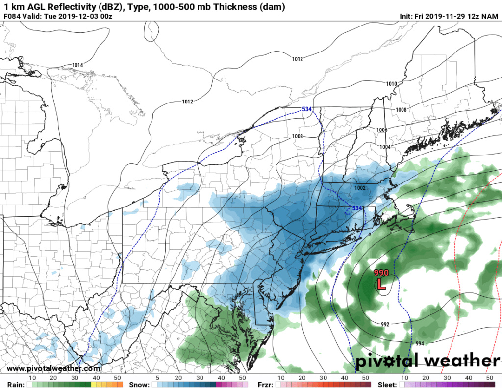
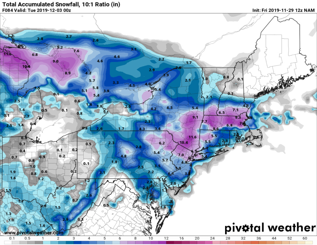
It is a 2 part storm with the initial front end overrunning that as depicted by the NAM and even a touch by the EURO shows snows to heavy icing N& W of NYC and then once the transfer to the coastal takes over and cranks we get a huge CCB (cold conveyor belt) of snow crush job for these same areas.dsix85 wrote:Is this an overrunning or two part event with the first wave coming through Sunday and then the storm developing off the coast and that’s the main piece of energy that will drive the precip totals? Do we anticipate this to undergo bombogenesis?
He has pointed it out very well in his 500mb post 2 up that once this cranks off tjis coast it will deepen rapidly maybe not to bombgensis but it will bring the goods.
NAM showing what could be a major ice to snow event for the NNJ,LIand S CT as well as the HV regions. More ice initially at the onset for the NNJ, EP, HV regions as a mid level warm area is locked in.
Great dynamic s setting up and synoptivmcally this is what the surface should be showing from this set up IMO.
Still cranking at hour 84 which is 2pmish Monday?
For your weenies eyes.
_________________
Mugs
AKA:King: Snow Weenie
Self Proclaimed
WINTER 2014-15 : 55.12" +.02 for 6 coatings (avg. 35")
WINTER 2015-16 Total - 29.8" (Avg 35")
WINTER 2016-17 : 39.5" so far

amugs- Advanced Forecaster - Mod

- Posts : 15095
Reputation : 213
Join date : 2013-01-07
Age : 54
Location : Hillsdale,NJ

aiannone- Senior Enthusiast - Mod

- Posts : 4815
Reputation : 92
Join date : 2013-01-07
Location : Saint James, LI (Northwest Suffolk Co.)
 Re: December 1st-3rd 2019 Winter Storm Potential
Extrapolated out NAM would be about 10-18" of white gold for NYC and 12" plus N&W.
NAMMMEDDDD!!!
NAMMMEDDDD!!!
_________________
Mugs
AKA:King: Snow Weenie
Self Proclaimed
WINTER 2014-15 : 55.12" +.02 for 6 coatings (avg. 35")
WINTER 2015-16 Total - 29.8" (Avg 35")
WINTER 2016-17 : 39.5" so far

amugs- Advanced Forecaster - Mod

- Posts : 15095
Reputation : 213
Join date : 2013-01-07
Age : 54
Location : Hillsdale,NJ
 Re: December 1st-3rd 2019 Winter Storm Potential
The initial is the appetizer, sleet and ice are best for stickage of the 3 course entree that follows, like an Italain Thanksgiving or Xmass dinner, very long duration and LOTS of great foods!
_________________
Mugs
AKA:King: Snow Weenie
Self Proclaimed
WINTER 2014-15 : 55.12" +.02 for 6 coatings (avg. 35")
WINTER 2015-16 Total - 29.8" (Avg 35")
WINTER 2016-17 : 39.5" so far

amugs- Advanced Forecaster - Mod

- Posts : 15095
Reputation : 213
Join date : 2013-01-07
Age : 54
Location : Hillsdale,NJ
 Re: December 1st-3rd 2019 Winter Storm Potential
For real?!! Jeeze I am not ready for this lol, do you think I should leave from CT back to NY tomorrow night rather than sunday If its going to be a icing event? So can we say theres a good chance no school Monday? Maybe NYC will have but like yonkers, white plains etc? How do you figure out the totals extrapolated out, now my question is will that CCB band have that dreaded subsidance or whatever its called keeping it from going west too far?amugs wrote:Extrapolated out NAM would be about 10-18" of white gold for NYC and 12" plus N&W.
NAMMMEDDDD!!!

jmanley32- Senior Enthusiast

- Posts : 20535
Reputation : 108
Join date : 2013-12-12
Age : 43
Location : Yonkers, NY
 Re: December 1st-3rd 2019 Winter Storm Potential
Timing Monday becomes critical now. If the snow doesn’t crank up until after 8 am, many schools and businesses may (mistakenly) open up - and if they do . . . it will NOT be a fun trip home for people in heavy afternoon/evening snow.

billg315- Advanced Forecaster - Mod

- Posts : 4483
Reputation : 185
Join date : 2015-01-24
Age : 50
Location : Flemington, NJ

jmanley32- Senior Enthusiast

- Posts : 20535
Reputation : 108
Join date : 2013-12-12
Age : 43
Location : Yonkers, NY
 Re: December 1st-3rd 2019 Winter Storm Potential
I work with kids with disabilities, the school will not take any chances if its progged to snow. Not a public school.billg315 wrote:Timing Monday becomes critical now. If the snow doesn’t crank up until after 8 am, many schools and businesses may (mistakenly) open up - and if they do . . . it will NOT be a fun trip home for people in heavy afternoon/evening snow.

jmanley32- Senior Enthusiast

- Posts : 20535
Reputation : 108
Join date : 2013-12-12
Age : 43
Location : Yonkers, NY
 Re: December 1st-3rd 2019 Winter Storm Potential
jmanley32 wrote:I work with kids with disabilities, the school will not take any chances if its progged to snow. Not a public school.billg315 wrote:Timing Monday becomes critical now. If the snow doesn’t crank up until after 8 am, many schools and businesses may (mistakenly) open up - and if they do . . . it will NOT be a fun trip home for people in heavy afternoon/evening snow.
I imagine if the forecast holds many schools/workplaces may pre-emptively close; but sometimes if it doesn’t look bad in the early morning they think they can sneak in a half day. That’s when you end up with people having 3-4 hour commutes home.

billg315- Advanced Forecaster - Mod

- Posts : 4483
Reputation : 185
Join date : 2015-01-24
Age : 50
Location : Flemington, NJ

CPcantmeasuresnow- Wx Statistician Guru

- Posts : 7274
Reputation : 230
Join date : 2013-01-07
Age : 103
Location : Eastern Orange County, NY
heehaw453- Advanced Forecaster

- Posts : 3906
Reputation : 86
Join date : 2014-01-20
Location : Bedminster Township, PA Elevation 600' ASL
 Re: December 1st-3rd 2019 Winter Storm Potential
jmanley32 wrote:For real?!! Jeeze I am not ready for this lol, do you think I should leave from CT back to NY tomorrow night rather than sunday If its going to be a icing event? So can we say theres a good chance no school Monday? Maybe NYC will have but like yonkers, white plains etc? How do you figure out the totals extrapolated out, now my question is will that CCB band have that dreaded subsidance or whatever its called keeping it from going west too far?amugs wrote:Extrapolated out NAM would be about 10-18" of white gold for NYC and 12" plus N&W.
NAMMMEDDDD!!!
Jman, timing for Sunday is morning, if you leave by 8 am Sunday, you should beat it. If you are not a morning person (like me), head back Saturday night.
_________________
Janet
Snowfall winter of 2023-2024 17.5"
Snowfall winter of 2022-2023 6.0"
Snowfall winter of 2021-2022 17.6" 1" sleet 2/25/22
Snowfall winter of 2020-2021 51.1"
Snowfall winter of 2019-2020 8.5"
Snowfall winter of 2018-2019 25.1"
Snowfall winter of 2017-2018 51.9"
Snowfall winter of 2016-2017 45.6"
Snowfall winter of 2015-2016 29.5"
Snowfall winter of 2014-2015 50.55"
Snowfall winter of 2013-2014 66.5"

Dunnzoo- Senior Enthusiast - Mod

- Posts : 4905
Reputation : 68
Join date : 2013-01-11
Age : 62
Location : Westwood, NJ
 Re: December 1st-3rd 2019 Winter Storm Potential
and like mugs said it's still snowing hard at 84 hrs these are not even the totals!heehaw453 wrote:
Well said.

jmanley32- Senior Enthusiast

- Posts : 20535
Reputation : 108
Join date : 2013-12-12
Age : 43
Location : Yonkers, NY
 Re: December 1st-3rd 2019 Winter Storm Potential
12z CMC dumps on the backend for the coast
_________________
-Alex Iannone-

aiannone- Senior Enthusiast - Mod

- Posts : 4815
Reputation : 92
Join date : 2013-01-07
Location : Saint James, LI (Northwest Suffolk Co.)
 Re: December 1st-3rd 2019 Winter Storm Potential
A wise Stat Man from the Hudson Valley once said on this site..."as December goes, so goes the winter"! Let it be written...let it be DONE!!!

docstox12- Wx Statistician Guru

- Posts : 8530
Reputation : 222
Join date : 2013-01-07
Age : 73
Location : Monroe NY
 Re: December 1st-3rd 2019 Winter Storm Potential
nice all the models are coming into some sort of agreement.aiannone wrote:12z CMC dumps on the backend for the coast

jmanley32- Senior Enthusiast

- Posts : 20535
Reputation : 108
Join date : 2013-12-12
Age : 43
Location : Yonkers, NY
 Re: December 1st-3rd 2019 Winter Storm Potential
My gosh it's still snowing on Tuesday on cmc!!!

jmanley32- Senior Enthusiast

- Posts : 20535
Reputation : 108
Join date : 2013-12-12
Age : 43
Location : Yonkers, NY
 Re: December 1st-3rd 2019 Winter Storm Potential
I’m hearing euro is a little warmer than it’s other runs. Can’t confirm right now though.
_________________
-Alex Iannone-

aiannone- Senior Enthusiast - Mod

- Posts : 4815
Reputation : 92
Join date : 2013-01-07
Location : Saint James, LI (Northwest Suffolk Co.)
 Re: December 1st-3rd 2019 Winter Storm Potential
docstox12 wrote:jmanley32 wrote:Holy euro...it doesn't really change to rain as much coasties even see a few inches and just 20 miles inland up to 8 to 12. Doc and those well north see Godzilla totals. Need this just a tad south of 00z and everyone sees one heck of a Dec snowstorm which we haven't seen in a long time.
Jman, I'm pulling for that all the way so we all get in on the goods here.NWS still has a slop fest for part one up here, 2 to 6 inches, then the snow event on Monday.Lot's of moving parts to come together.
At least NWS by you is throwing out some numbers already. NWS Albany waits until 12 hours before start time to put out any numbers. I know this one has a complicated thermal profile but still. N and W of city will do well with this one but there will probably be mixing Sunday night(unless you are way N and W) with warming aloft and lull in precip intensity. Monday could be fun. I'm 75 miles north of NYC and I'm expecting 6-10 when all is said and done by Monday night.

hyde345- Pro Enthusiast

- Posts : 1082
Reputation : 48
Join date : 2013-01-08
Location : Hyde Park, NY
 Re: December 1st-3rd 2019 Winter Storm Potential
No input from Frank ?
Artechmetals- Pro Enthusiast

- Posts : 571
Reputation : 3
Join date : 2014-01-01
Age : 57
Location : Wayne , NJ
 Re: December 1st-3rd 2019 Winter Storm Potential
Lots to digest over the last 24 hours. I’ll put together a first call snow map and small write up either late tonight or tomorrow morning. Many are in line for their first accumulating snow of this Meteorological Winter. There will also be some concern of ice accretion in parts of NNJ.
Latest EURO

Latest EURO

_________________
_______________________________________________________________________________________________________
CLICK HERE to view NJ Strong Snowstorm Classifications
Page 4 of 8 •  1, 2, 3, 4, 5, 6, 7, 8
Permissions in this forum:
You cannot reply to topics in this forum|
|
|

 Home
Home

