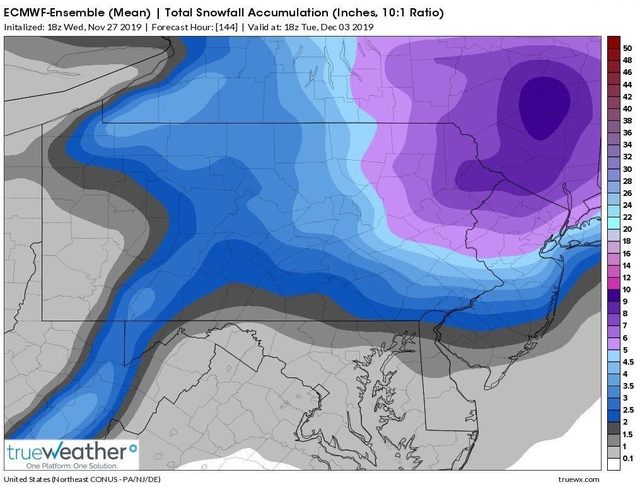
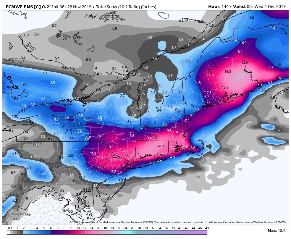
December 1st-3rd 2019 Winter Storm Potential
+27
brownie
Vinnydula
jimv45
Artechmetals
CPcantmeasuresnow
dsix85
Math23x7
weatherwatchermom
aiannone
Irish
Frank_Wx
dkodgis
frank 638
algae888
billg315
Dunnzoo
rb924119
hyde345
skinsfan1177
nutleyblizzard
SoulSingMG
docstox12
amugs
jmanley32
heehaw453
Sanchize06
sroc4
31 posters
Page 2 of 8 •  1, 2, 3, 4, 5, 6, 7, 8
 Re: December 1st-3rd 2019 Winter Storm Potential
sroc4 wrote:rb924119 wrote:sroc4 wrote:rb924119 wrote:Personally, I would not set high expectations for this system, folks. I don’t think this system will be much of a winter event based on what I’m seeing, but hey, I’ll still track it!
While I think I know where your at, care to elaborate a little?
Doing this from mobile for a third time is annoying, but because I love you guys, I’ll forward the cliff notes version
The below is a post from Armando’s board in response to if my reason why is because it will be too warm:
“Yes, but that’s only part of it. The trajectory of the system as well as how I expect this trajectory to evolve as a result of the ambient hemispheric synoptics are the others. I have posted more technical discussion over on 33 if you’re there, but basically the evolution of this system is not one that is auspicious for significant winter weather for our area in my opinion. Storms that come from the west are almost always overmodeled in their precipitation fields, only to seemingly disappear as lead time decreases. This is supported when you look at mid-level streamflow, which depicts your “deep” moisture source to be almost exclusively from the Pacific. This then gets downsloped over the Rockies with very little additional moisture flux from the Gulf and Atlantic. Secondarily, this system reaches maturity over the Upper Midwest, and then slowly decays as it continues east-southeastward. So, while it presents itself as a “classic bowling ball” low, in reality, almost all of the dynamics associated with a more classic deepening/maturing cyclone through the column, one that actively is closing off south and/or east of our area, will be non-existent. The mid-levels are not organized enough to support this, and the window of *temporary* reorganization is very small given the progressive nature of the system. Third, when you look at the state of the ambient synoptic atmosphere/ocean couplet, it supports less of a suppressing effect on this system, which makes me think that we end up seeing it pass directly over or even slightly north of our area. This does two things: 1. Prevents us from being in any favorable location for any remaining dynamics to assist in precipitation rates/thermal profiles, as we will get dry slotted. 2. Allow for the stale Pacific air that this system is bringing with it to dominate, as the warm advection out ahead of this would be not be countered. This leads me to additional points that because this system starts so far north/west, the effects of the frontrunning warm advection will be enhanced for us, and without any fresh injection of cold air from a northern stream system, we have no real way to mitigate it in-situ. Secondly, once you get through the initial warm advection surge, conditions will be generally unsettled with showery type precipitation and generally “milder” conditions as the mid- and low-level lows pass overhead.”
I think today’s 12z EURO Op was pretty close in its depiction of sensible effects at the surface, though I fear it could even get a little worse than that by the time it’s over. If you want me to diagnose further, though, let me know, but I think that you can synthesize the details I left out regarding the synoptic hemispheric/oceanic alignments haha
So sorry oh mighty Ray. For I do not mean to trouble you. I know how difficult it can be to “copy and paste”, especially for a third time. I hope your not experiencing any pronounced carpal tunnel as a result. That said I appreciate the analysis.

My emoticons aren’t showing up!!! There was supposed to be winking faces in there, I swear!!! That wasn’t meant to be negatively snarky, rather, entertainingly snarky haha though I think you know me well enough to interpret it that way (I hope haha). I will say, though, my thumbs are getting a bit tired lmaooo
rb924119- Meteorologist

- Posts : 6928
Join date : 2013-02-06
 Re: December 1st-3rd 2019 Winter Storm Potential
jmanley32 wrote:Wasnt there a system where you said you had egg on your face? I could sworn I saw that which also made me laugh cuz this is not a exact science. And yes you were partially right, no one can get it exact, if they did that would be amazing.rb924119 wrote:jmanley32 wrote:ok so last time u were wrong so sorry but hope that happens again this time lol. Ur still smart but I oh so want you to be wrong.rb924119 wrote:Personally, I would not set high expectations for this system, folks. I don’t think this system will be much of a winter event based on what I’m seeing, but hey, I’ll still track it!
How was I wrong last time? Lol there were “surprise” snow totals all the way down into Putnam county and into Connecticut. Even NW NJ had some snow out of that. I was never supposed to make it into the city. That said, I never did issue an official forecast so I guess it’s a mute point. But all that said, part of me hopes I’m wrong too, and no hard feelings hahaha :p
Oo yeah, that was the first one! Definitely blew that one, I fully admit that lmao but my last one went pretty well, but again, it was more of just a broad statement that north and west of the main 95 corridor had to watch out for sneaky snow/light accumulations. Similar to the one I just posted tonight; no “official” forecast/map or anything like that.
rb924119- Meteorologist

- Posts : 6928
Join date : 2013-02-06
 Re: December 1st-3rd 2019 Winter Storm Potential
Quick update. Not thrilled at some of the subtle trends regarding the blocking features I outlined, although also not that surprised again given some of my concerns outlined above.
That said an initial over running event for snow on Sunday is possible. Details still too far out...and dont look away from Monday yet either...not dead yet.
And Ray it did come off a little snarky when I first read through it (knee jerk reaction), but your right I know you well enough now to know what it was all about. I was playing snarky back at ya. All good in the hood.
_________________
"In weather and in life, there's no winning and losing; there's only winning and learning."
WINTER 2012/2013 TOTALS 43.65"WINTER 2017/2018 TOTALS 62.85" WINTER 2022/2023 TOTALS 4.9"
WINTER 2013/2014 TOTALS 64.85"WINTER 2018/2019 TOTALS 14.25" WINTER 2023/2024 TOTALS 13.1"
WINTER 2014/2015 TOTALS 71.20"WINTER 2019/2020 TOTALS 6.35"
WINTER 2015/2016 TOTALS 35.00"WINTER 2020/2021 TOTALS 37.75"
WINTER 2016/2017 TOTALS 42.25"WINTER 2021/2022 TOTALS 31.65"

sroc4- Admin

- Posts : 8354
Reputation : 302
Join date : 2013-01-07
Location : Wading River, LI
 Re: December 1st-3rd 2019 Winter Storm Potential
NWS trended warmer for me.Snow , to mix rain and snow, then ending as snow.It was all snow yesterday.Hopefully, the ground will get covered for the first measurable snow up here.

docstox12- Wx Statistician Guru

- Posts : 8530
Reputation : 222
Join date : 2013-01-07
Age : 73
Location : Monroe NY
 Re: December 1st-3rd 2019 Winter Storm Potential
docstox12 wrote:NWS trended warmer for me.Snow , to mix rain and snow, then ending as snow.It was all snow yesterday.Hopefully, the ground will get covered for the first measurable snow up here.
GFS was warmer this morning, seeing the concerns of Ray and Scott trending... cold just doesn't make it too far east, mostly interior PA and New England.
Happy Thanksgiving everyone!
_________________
Janet
Snowfall winter of 2023-2024 17.5"
Snowfall winter of 2022-2023 6.0"
Snowfall winter of 2021-2022 17.6" 1" sleet 2/25/22
Snowfall winter of 2020-2021 51.1"
Snowfall winter of 2019-2020 8.5"
Snowfall winter of 2018-2019 25.1"
Snowfall winter of 2017-2018 51.9"
Snowfall winter of 2016-2017 45.6"
Snowfall winter of 2015-2016 29.5"
Snowfall winter of 2014-2015 50.55"
Snowfall winter of 2013-2014 66.5"
Dunnzoo- Senior Enthusiast - Mod

- Posts : 4905
Reputation : 68
Join date : 2013-01-11
Age : 62
Location : Westwood, NJ
 Re: December 1st-3rd 2019 Winter Storm Potential
Its 4 days away one or two models runs c and that isn't the final solution we have time. Also the eps showed some big hitters monsters

skinsfan1177- Senior Enthusiast

- Posts : 4485
Reputation : 35
Join date : 2013-01-07
Age : 46
Location : Point Pleasant Boro
 Re: December 1st-3rd 2019 Winter Storm Potential
Does anyone know where the eps stamps are the 50 on weatherbell? Since their new format I can't find them. I hate the new format.

jmanley32- Senior Enthusiast

- Posts : 20535
Reputation : 108
Join date : 2013-12-12
Age : 43
Location : Yonkers, NY
 Re: December 1st-3rd 2019 Winter Storm Potential
12z GFS seems to stick with the idea of the low cutting to our west with a brief overrunning event; warm air spreading north changing any frozen precip to rain and then the precip being gone before the cold air crashes in behind. Right now it shows most of us starting as snow early Sunday, but fairly quickly turning over to predominately rain. Exception seems to be further north in the Hudson Valley where the snow hangs in longer and may therefore accumulate a little before going over to rain.

billg315- Advanced Forecaster - Mod

- Posts : 4483
Reputation : 185
Join date : 2015-01-24
Age : 50
Location : Flemington, NJ
 Re: December 1st-3rd 2019 Winter Storm Potential
If the primary doesn't transfer sooner (Delmarva), then coastal won't be much white stuff for most folks. Yesterday models showed a better ridge pushing down on the low forcing it lower latitude and allowing for transfer at more favorable latitude. This allowed colder air for better WAA snows as well as some some snows from coastal low.
I would set my over/under at an inch for now for most folks. Can't get much lower than that so no disappointment.
I would set my over/under at an inch for now for most folks. Can't get much lower than that so no disappointment.
heehaw453- Advanced Forecaster

- Posts : 3906
Reputation : 86
Join date : 2014-01-20
Location : Bedminster Township, PA Elevation 600' ASL
 Re: December 1st-3rd 2019 Winter Storm Potential
GFS is having some problems with this system IMO. 24 hours or so ago it was doing a loop with the secondary low. Some accumulating snow is still on the table for people 50 miles N and W with some rain and sleet also likely. Thermal profiles are tricky and we are still 4 days away. Happy Thanksgiving to all.

hyde345- Pro Enthusiast

- Posts : 1082
Reputation : 48
Join date : 2013-01-08
Location : Hyde Park, NY
 Re: December 1st-3rd 2019 Winter Storm Potential
hyde345 wrote:GFS is having some problems with this system IMO. 24 hours or so ago it was doing a loop with the secondary low. Some accumulating snow is still on the table for people 50 miles N and W with some rain and sleet also likely. Thermal profiles are tricky and we are still 4 days away. Happy Thanksgiving to all.
I agree more significant accumulations N&W of 95 are more likely and it's not a dead threat yet IMO. Coastal redevelopment 100 or even 50 miles south and east will have significant implications on the forecast and this is quite possible with a 50/50 low in the mix. Moreover, at 5 days out model error is way too high to throw the towel in. Just have to see the next few days.
heehaw453- Advanced Forecaster

- Posts : 3906
Reputation : 86
Join date : 2014-01-20
Location : Bedminster Township, PA Elevation 600' ASL
 Re: December 1st-3rd 2019 Winter Storm Potential
The Euro and GFS have flip-flopped with the Euro being the coldest solution. Anyway we have two ways to snow with this system one is the front end over-running precip and the second is where the secondary develops and if it closes off at H5 where the defamation band sets up. I feel more confident with the over-running who knows where the secondary will form. models will not have a good idea on this until Friday or even Saturday.

algae888- Advanced Forecaster

- Posts : 5311
Reputation : 46
Join date : 2013-02-05
Age : 62
Location : mt. vernon, new york
 Re: December 1st-3rd 2019 Winter Storm Potential
I"m hearing the latest EPS run has many members showing big hits along the coast.

nutleyblizzard- Senior Enthusiast

- Posts : 1954
Reputation : 41
Join date : 2014-01-30
Age : 58
Location : Nutley, new jersey
 Re: December 1st-3rd 2019 Winter Storm Potential
EPS just came back and from its Dr. No stand and said I am Dr Yes. Time will tell. The model dance has and will be fun. Need better sampling of pieces of energy or playas.
_________________
Mugs
AKA:King: Snow Weenie
Self Proclaimed
WINTER 2014-15 : 55.12" +.02 for 6 coatings (avg. 35")
WINTER 2015-16 Total - 29.8" (Avg 35")
WINTER 2016-17 : 39.5" so far

amugs- Advanced Forecaster - Mod

- Posts : 15095
Reputation : 213
Join date : 2013-01-07
Age : 54
Location : Hillsdale,NJ
 Re: December 1st-3rd 2019 Winter Storm Potential
Hopefully we all get snow  for everyone this Saturday day I am putting up my Christmas lights it would look nice to see
  snow for Sunday
frank 638- Senior Enthusiast

- Posts : 2843
Reputation : 37
Join date : 2016-01-01
Age : 40
Location : bronx ny
 Re: December 1st-3rd 2019 Winter Storm Potential
Snow on Monday or Sunday night please extend the weekend for us teachers!!

jmanley32- Senior Enthusiast

- Posts : 20535
Reputation : 108
Join date : 2013-12-12
Age : 43
Location : Yonkers, NY

skinsfan1177- Senior Enthusiast

- Posts : 4485
Reputation : 35
Join date : 2013-01-07
Age : 46
Location : Point Pleasant Boro
 Re: December 1st-3rd 2019 Winter Storm Potential
So we are not going to talk about the N(ot) A M(odel) ?



dkodgis- Senior Enthusiast

- Posts : 2560
Reputation : 98
Join date : 2013-12-29

skinsfan1177- Senior Enthusiast

- Posts : 4485
Reputation : 35
Join date : 2013-01-07
Age : 46
Location : Point Pleasant Boro
heehaw453- Advanced Forecaster

- Posts : 3906
Reputation : 86
Join date : 2014-01-20
Location : Bedminster Township, PA Elevation 600' ASL
 Re: December 1st-3rd 2019 Winter Storm Potential
The primary is hanging on too long on the latest mode runs. By the time the secondary develops off the coast our boundary temps are torched.
The blocking has trended weaker too. Considering the -NAO was/is the number one signal we need on our side in this setup that is not good.
Let’s see where we stand tomorrow. But confidence down tremendously today.
The blocking has trended weaker too. Considering the -NAO was/is the number one signal we need on our side in this setup that is not good.
Let’s see where we stand tomorrow. But confidence down tremendously today.
_________________
_______________________________________________________________________________________________________
CLICK HERE to view NJ Strong Snowstorm Classifications

SoulSingMG- Senior Enthusiast

- Posts : 2853
Reputation : 74
Join date : 2013-12-11
Location : Long Island City, NY
 Re: December 1st-3rd 2019 Winter Storm Potential
One thing I would like to see is a shift 50-75 miles south and I think it's possible.

skinsfan1177- Senior Enthusiast

- Posts : 4485
Reputation : 35
Join date : 2013-01-07
Age : 46
Location : Point Pleasant Boro
 Re: December 1st-3rd 2019 Winter Storm Potential
_________________
_______________________________________________________________________________________________________
CLICK HERE to view NJ Strong Snowstorm Classifications
 Re: December 1st-3rd 2019 Winter Storm Potential
Big improvements on the GFS. Aside from the warm surface temps, looked very good like the Euro ens and Icon
Sanchize06- Senior Enthusiast

- Posts : 1041
Reputation : 21
Join date : 2013-02-05
Location : Union Beach, NJ
 Re: December 1st-3rd 2019 Winter Storm Potential
CMC, Euro, Ukie all give northern areas big snows. I'm not completely sold on that because a lot of that is sleet but I think we get a plowable snow after all is said. Even GFS gives me 6 inches as upper level low tracks south and east of area.

hyde345- Pro Enthusiast

- Posts : 1082
Reputation : 48
Join date : 2013-01-08
Location : Hyde Park, NY
heehaw453- Advanced Forecaster

- Posts : 3906
Reputation : 86
Join date : 2014-01-20
Location : Bedminster Township, PA Elevation 600' ASL
Page 2 of 8 •  1, 2, 3, 4, 5, 6, 7, 8
Permissions in this forum:
You cannot reply to topics in this forum|
|
|

 Home
Home


