
 Search
December 1st-2nd Winter Storm
Page 1 of 5 • 1, 2, 3, 4, 5 ![]()

December 1st-2nd Winter Storm
![]() by Frank_Wx Sat Nov 30, 2019 10:03 am
by Frank_Wx Sat Nov 30, 2019 10:03 am
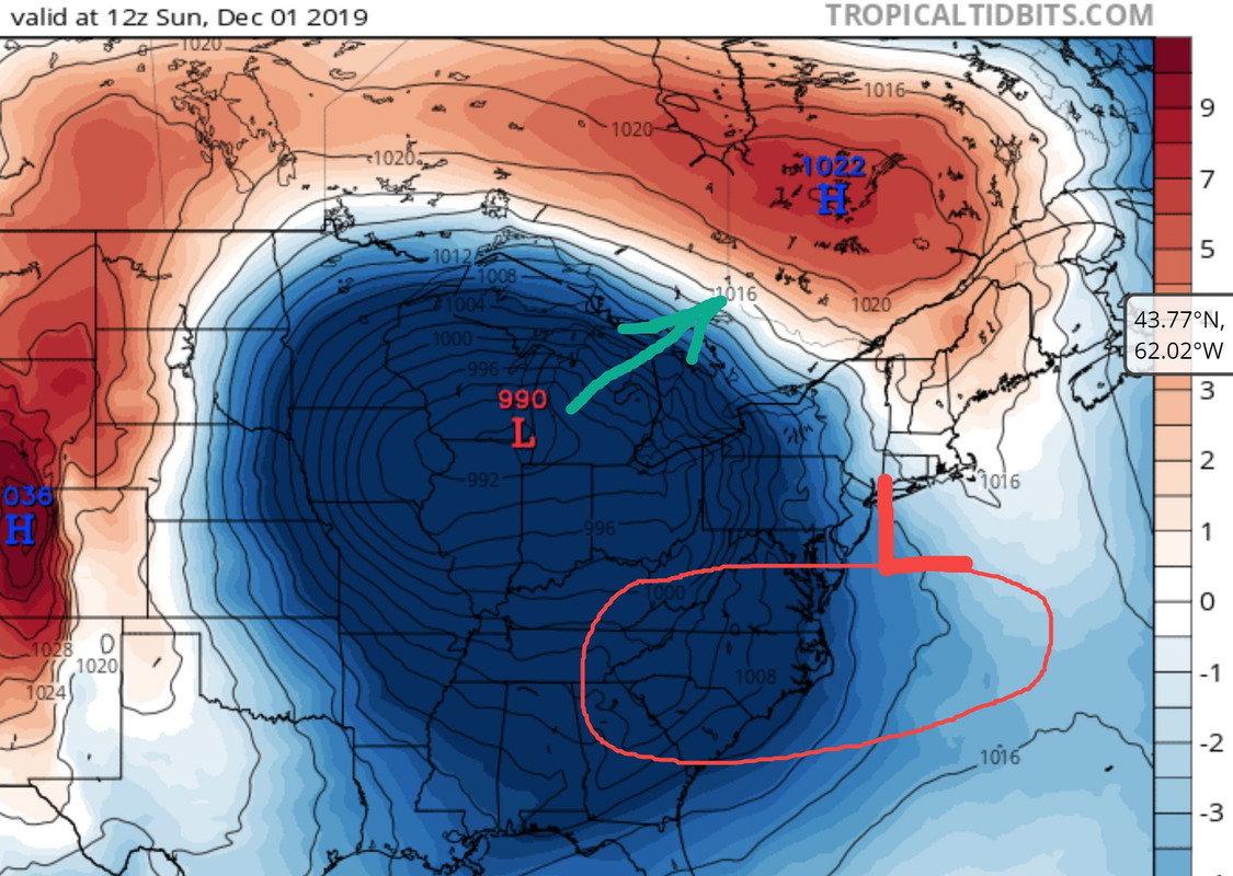
The set-up is straight forward. The -NAO (positive heights or ridging over Greenland) buckled the jet stream which causes a traffic jam when storms pass through our side of the hemisphere. For example, the storm system that effected our area 3 days ago is sitting off the coast of eastern Canada. The low pressure system that develops in the Midwest, bringing blizzard conditions to the Dakotas and Minnesota, runs into a STOP sign known as a banana-like High Pressure system. On this graphic you can see the isobars pointing or pulling toward the east coast (circled area). Because of the -NAO and 'blockiness' in the pattern, the High Pressure is locked in and the storm runs into resistance. Therefore, a secondary low pressure is forced to develop just off the coast of NJ.
The issue with these type of set-ups, especially very early on in the cold weather season, is tropical air is still near our area. A 990mb low that reaches Chicago's latitude WILL initially raise our temperatures along the coast. The winds are from the south-southwest. By the time the secondary low takes over, it needs to deepen (or strengthen) quickly so it can pull the cold air back toward the coast and change precipitation from rain to snow. The key with this system will be the timing and speed at which this process occurs.
Some people have talked about the GFS' inconsistency during this time. I think the opposite. The GFS has a good handle on the track of this storm but it could be having trouble with the temperatures.
Thursday's GFS valid Monday 1am:

Today's GFS valid Monday 1am:

The location of the secondary low is pretty close considering how many runs apart these are. Speaking of location, the low is very close to the coast. Temps are above freezing for almost everyone including places N&W of NYC until you get into NEPA and CNY. As the low begins to pull away and slowly strengthen, temps transition to below freezing.
Here is the evolution of 850mb temps according to the GFS:
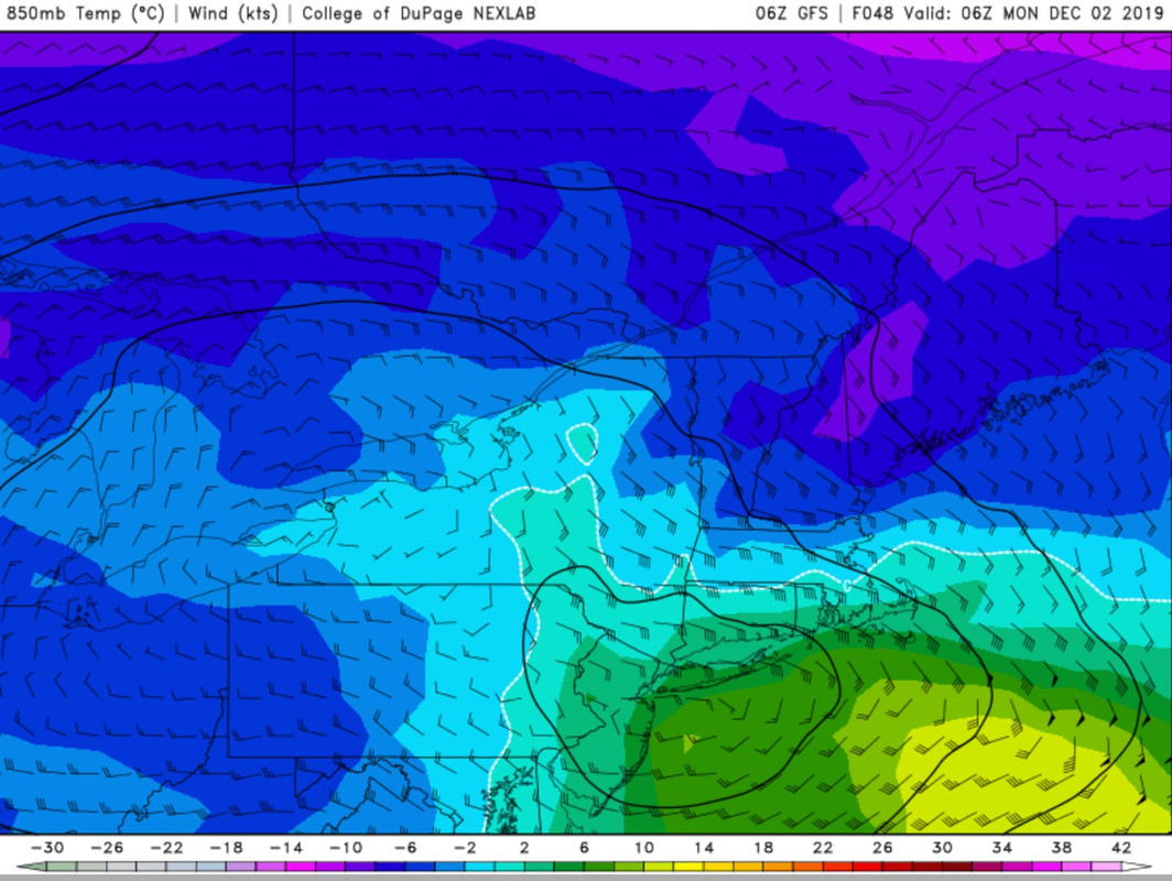
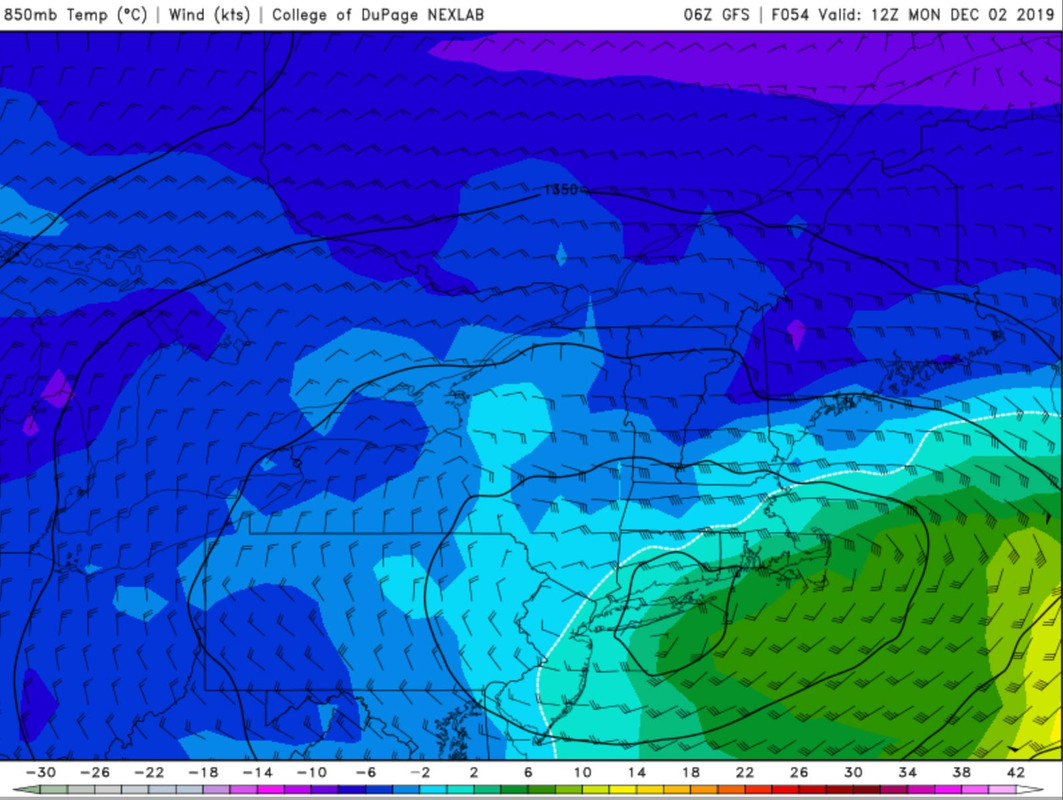
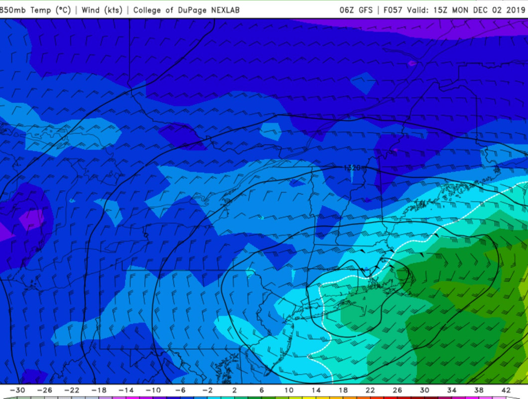
The dotted white line represents the freezing line. In this case, the freezing line does not pass NYC until about 13z, which is 8am. By that point there is still a few hours left of the storm and most likely snow is falling down, however, the secondary low is not well organized and not a lot of moisture content is left. Meaning, the qpf (or precip) left to fall would not yield significant snow amounts for NYC and points south. There is simply not a lot of 'juice' accompanying the secondary low. If this low were to form further south, near Delaware or even AC SNJ, it would have given us a better opportunity to see more qpf fall in the form of snow.
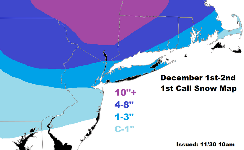
My initial call believes there will be some accumulation around the NYC area. The changeover to snow should occur around 8-9am on Monday. It will have a hard time sticking at first but should gradually do so as the storm pulls east. This is a true Godzilla for CNY toward Upstate NY. For those in-between, it is a tough call. There is a chance those in the 1-3 zone in NJ could see 4-5" depending on the timing of the changeover and rate at which precip falls. Same goes for those located in the 4-8 zone, where some models do show 9-10" falling. Such wide ranges are expected with this type of storm. I chose ranges that I believe will be most common snow accumulations in these areas, not necessarily trying to pick ranges I believe snow accumulations could actually amount to. A final call map will be issued tomorrow if necessary.
Should be a fun one to track!
_________________
_______________________________________________________________________________________________________
CLICK HERE to view NJ Strong Snowstorm Classifications

Frank_Wx- Godzilla Seeker

- Posts : 21305
Reputation : 328
Join date : 2013-01-05
Age : 31
Location : Jersey City, NJ -

Re: December 1st-2nd Winter Storm
![]() by hyde345 Sat Nov 30, 2019 10:25 am
by hyde345 Sat Nov 30, 2019 10:25 am

hyde345- Pro Enthusiast

- Posts : 1082
Reputation : 48
Join date : 2013-01-08
Location : Hyde Park, NY
Re: December 1st-2nd Winter Storm
![]() by heehaw453 Sat Nov 30, 2019 10:35 am
by heehaw453 Sat Nov 30, 2019 10:35 am
Not that anyone in here cares, but i think the 10"+ line goes more east in MA. Just outside of Red Sox Suck probably gets slammed.
Also, there may be banding that sets up on the western edge, so i could see NEPA getting hefty totals. It just all depends on the coastal, but the higher the latitude better chance.
heehaw453- Advanced Forecaster

- Posts : 3906
Reputation : 86
Join date : 2014-01-20
Location : Bedminster Township, PA Elevation 600' ASL
Re: December 1st-2nd Winter Storm
![]() by weatherwatchermom Sat Nov 30, 2019 10:39 am
by weatherwatchermom Sat Nov 30, 2019 10:39 am

weatherwatchermom- Senior Enthusiast

- Posts : 3733
Reputation : 77
Join date : 2014-11-25
Age : 60
Location : Hazlet Township, NJ
Re: December 1st-2nd Winter Storm
![]() by jmanley32 Sat Nov 30, 2019 11:07 am
by jmanley32 Sat Nov 30, 2019 11:07 am

jmanley32- Senior Enthusiast
- Posts : 20512
Reputation : 108
Join date : 2013-12-12
Age : 42
Location : Yonkers, NY
Re: December 1st-2nd Winter Storm
![]() by docstox12 Sat Nov 30, 2019 11:13 am
by docstox12 Sat Nov 30, 2019 11:13 am
There are wild cards in this scenario and we could be pleasantly surprised with this.Staying optimistic.

docstox12- Wx Statistician Guru

- Posts : 8501
Reputation : 222
Join date : 2013-01-07
Age : 73
Location : Monroe NY
Re: December 1st-2nd Winter Storm
![]() by frank 638 Sat Nov 30, 2019 11:17 am
by frank 638 Sat Nov 30, 2019 11:17 am
frank 638- Senior Enthusiast
- Posts : 2824
Reputation : 37
Join date : 2016-01-01
Age : 40
Location : bronx ny
Re: December 1st-2nd Winter Storm
![]() by jimv45 Sat Nov 30, 2019 11:23 am
by jimv45 Sat Nov 30, 2019 11:23 am
jimv45- Senior Enthusiast
- Posts : 1168
Reputation : 36
Join date : 2013-09-20
Location : Hopewell jct.
Re: December 1st-2nd Winter Storm
![]() by amugs Sat Nov 30, 2019 11:27 am
by amugs Sat Nov 30, 2019 11:27 am
I disagree with the HFS analysis. The LP has jumped around and the ULL was a shredded piece of cheddar 3 days ago whilst the beloved EPS and EURO have been steadfast on a consolidated ULL and an accumulating snow NYC metro North.
Here's to white gold for all on this board. JMAN thanks for bringing your Debbie way wah to banter where it belongs with the other IMBY concerns.
Watch SROC and LI jackpot somehow. I'd not post till next year if this happens LOL!!
_________________
Mugs
AKA:King: Snow Weenie
Self Proclaimed
WINTER 2014-15 : 55.12" +.02 for 6 coatings (avg. 35")
WINTER 2015-16 Total - 29.8" (Avg 35")
WINTER 2016-17 : 39.5" so far

amugs- Advanced Forecaster - Mod

- Posts : 15093
Reputation : 213
Join date : 2013-01-07
Age : 54
Location : Hillsdale,NJ
Re: December 1st-2nd Winter Storm
![]() by hyde345 Sat Nov 30, 2019 11:30 am
by hyde345 Sat Nov 30, 2019 11:30 am
jimv45 wrote:Yea Hyde looks good for Dutchess county, I now live in Saugerties Ny expecting over a foot here!!
You're in a great spot there Jim for this one. I would say a foot looks quite likely. Catskills to Albany is the sweet spot. Let us know how much you get.
hyde345- Pro Enthusiast
- Posts : 1082
Reputation : 48
Join date : 2013-01-08
Location : Hyde Park, NY
Re: December 1st-2nd Winter Storm
![]() by docstox12 Sat Nov 30, 2019 11:35 am
by docstox12 Sat Nov 30, 2019 11:35 am
I'm just south of the 10 plus inch line so I figure closer to 8 in the 4 to 8 Frank has me in.We will see.
docstox12- Wx Statistician Guru
- Posts : 8501
Reputation : 222
Join date : 2013-01-07
Age : 73
Location : Monroe NY
Re: December 1st-2nd Winter Storm
![]() by hyde345 Sat Nov 30, 2019 11:46 am
by hyde345 Sat Nov 30, 2019 11:46 am
docstox12 wrote:hyde345 and jimv45, enjoy this classic old timey "areas and W of the City" getting more snow.These maps are exactly what I remember back in the 1960's when I lived in Fort Lee NJ right next to the City.
I'm just south of the 10 plus inch line so I figure closer to 8 in the 4 to 8 Frank has me in.We will see.
Doc, you and CP are going to get some good snows too. I would be surprised if you got less than 6. I'm expecting 8-12 in my neck of the woods and Jim is going to get hammered. Hopefully everybody sees some white gold.
hyde345- Pro Enthusiast
- Posts : 1082
Reputation : 48
Join date : 2013-01-08
Location : Hyde Park, NY
Re: December 1st-2nd Winter Storm
![]() by sroc4 Sat Nov 30, 2019 11:52 am
by sroc4 Sat Nov 30, 2019 11:52 am
amugs wrote:Good call at this point and nice inclusive write up.these are complex storms to call due to the positioning of the surface LP.
I disagree with the HFS analysis. The LP has jumped around and the ULL was a shredded piece of cheddar 3 days ago whilst the beloved EPS and EURO have been steadfast on a consolidated ULL and an accumulating snow NYC metro North.
Here's to white gold for all on this board. JMAN thanks for bringing your Debbie way wah to banter where it belongs with the other IMBY concerns.
Watch SROC and LI jackpot somehow. I'd not post till next year if this happens LOL!!
Lol. They key here is the 850mb low. CMC is much colder. A direct result of 850mb low placement and strength. . I will say this the 500mb ULL is pretty consistent in its placement and intensity south of LI in the modeling right now. The 850mb level is the question. I have to look at soundings to see just how deep of a warm nose it actually is. Because if it’s shallow and there is a very subtle shift in timing placement and strength at 850 then the outcome for coastal sections goes from T-1” to 3-6”. Again very subtle shifts is all it takes. Way too much time left to throw it in coastal peeps.
_________________
"In weather and in life, there's no winning and losing; there's only winning and learning."
WINTER 2012/2013 TOTALS 43.65"WINTER 2017/2018 TOTALS 62.85" WINTER 2022/2023 TOTALS 4.9"
WINTER 2013/2014 TOTALS 64.85"WINTER 2018/2019 TOTALS 14.25" WINTER 2023/2024 TOTALS 13.1"
WINTER 2014/2015 TOTALS 71.20"WINTER 2019/2020 TOTALS 6.35"
WINTER 2015/2016 TOTALS 35.00"WINTER 2020/2021 TOTALS 37.75"
WINTER 2016/2017 TOTALS 42.25"WINTER 2021/2022 TOTALS 31.65"

sroc4- Admin
- Posts : 8331
Reputation : 301
Join date : 2013-01-07
Location : Wading River, LI
Re: December 1st-2nd Winter Storm
![]() by jimv45 Sat Nov 30, 2019 11:52 am
by jimv45 Sat Nov 30, 2019 11:52 am
jimv45- Senior Enthusiast
- Posts : 1168
Reputation : 36
Join date : 2013-09-20
Location : Hopewell jct.
Re: December 1st-2nd Winter Storm
![]() by oldtimer Sat Nov 30, 2019 11:53 am
by oldtimer Sat Nov 30, 2019 11:53 am
oldtimer- Senior Enthusiast
- Posts : 1103
Reputation : 14
Join date : 2013-01-16
Age : 78
Location : Port Jefferson Station Suffolk County
Re: December 1st-2nd Winter Storm
![]() by sroc4 Sat Nov 30, 2019 11:54 am
by sroc4 Sat Nov 30, 2019 11:54 am
_________________
"In weather and in life, there's no winning and losing; there's only winning and learning."
WINTER 2012/2013 TOTALS 43.65"WINTER 2017/2018 TOTALS 62.85" WINTER 2022/2023 TOTALS 4.9"
WINTER 2013/2014 TOTALS 64.85"WINTER 2018/2019 TOTALS 14.25" WINTER 2023/2024 TOTALS 13.1"
WINTER 2014/2015 TOTALS 71.20"WINTER 2019/2020 TOTALS 6.35"
WINTER 2015/2016 TOTALS 35.00"WINTER 2020/2021 TOTALS 37.75"
WINTER 2016/2017 TOTALS 42.25"WINTER 2021/2022 TOTALS 31.65"
sroc4- Admin
- Posts : 8331
Reputation : 301
Join date : 2013-01-07
Location : Wading River, LI
Re: December 1st-2nd Winter Storm
![]() by docstox12 Sat Nov 30, 2019 11:59 am
by docstox12 Sat Nov 30, 2019 11:59 am
sroc4 wrote:Unfort it’s almost impossible for me to jackpot Mugs. HOWEVER, if I get 3-6 everyone gets more. So I’ll take one for the team.
Doc, that low forming near you could really help your area on Monday night.Your in it for white gold as Mugs says.
In the words of the immortal Yogi Berra...."it ain't over 'til it's OVER".
docstox12- Wx Statistician Guru
- Posts : 8501
Reputation : 222
Join date : 2013-01-07
Age : 73
Location : Monroe NY
Re: December 1st-2nd Winter Storm
![]() by docstox12 Sat Nov 30, 2019 12:02 pm
by docstox12 Sat Nov 30, 2019 12:02 pm
hyde345 wrote:docstox12 wrote:hyde345 and jimv45, enjoy this classic old timey "areas and W of the City" getting more snow.These maps are exactly what I remember back in the 1960's when I lived in Fort Lee NJ right next to the City.
I'm just south of the 10 plus inch line so I figure closer to 8 in the 4 to 8 Frank has me in.We will see.
Doc, you and CP are going to get some good snows too. I would be surprised if you got less than 6. I'm expecting 8-12 in my neck of the woods and Jim is going to get hammered. Hopefully everybody sees some white gold.
Yep, jim and hyde, CP and I are in the middle of the City-Coast areas and up there in the sweet spot, so we should get that 6.Anyway, a two day event with snow in there is a lot of fun to watch!
docstox12- Wx Statistician Guru
- Posts : 8501
Reputation : 222
Join date : 2013-01-07
Age : 73
Location : Monroe NY
Re: December 1st-2nd Winter Storm
![]() by Frank_Wx Sat Nov 30, 2019 12:08 pm
by Frank_Wx Sat Nov 30, 2019 12:08 pm
_________________
_______________________________________________________________________________________________________
CLICK HERE to view NJ Strong Snowstorm Classifications
Frank_Wx- Godzilla Seeker
- Posts : 21305
Reputation : 328
Join date : 2013-01-05
Age : 31
Location : Jersey City, NJ -
Re: December 1st-2nd Winter Storm
![]() by weatherwatchermom Sat Nov 30, 2019 12:09 pm
by weatherwatchermom Sat Nov 30, 2019 12:09 pm
sroc4 wrote:amugs wrote:Good call at this point and nice inclusive write up.these are complex storms to call due to the positioning of the surface LP.
I disagree with the HFS analysis. The LP has jumped around and the ULL was a shredded piece of cheddar 3 days ago whilst the beloved EPS and EURO have been steadfast on a consolidated ULL and an accumulating snow NYC metro North.
Here's to white gold for all on this board. JMAN thanks for bringing your Debbie way wah to banter where it belongs with the other IMBY concerns.
Watch SROC and LI jackpot somehow. I'd not post till next year if this happens LOL!!
Lol. They key here is the 850mb low. CMC is much colder. A direct result of 850mb low placement and strength. . I will say this the 500mb ULL is pretty consistent in its placement and intensity south of LI in the modeling right now. The 850mb level is the question. I have to look at soundings to see just how deep of a warm nose it actually is. Because if it’s shallow and there is a very subtle shift in timing placement and strength at 850 then the outcome for coastal sections goes from T-1” to 3-6”. Again very subtle shifts is all it takes. Way too much time left to throw it in coastal peeps.
thanks for the bone sroc!!
weatherwatchermom- Senior Enthusiast
- Posts : 3733
Reputation : 77
Join date : 2014-11-25
Age : 60
Location : Hazlet Township, NJ
Re: December 1st-2nd Winter Storm
![]() by weatherwatchermom Sat Nov 30, 2019 12:10 pm
by weatherwatchermom Sat Nov 30, 2019 12:10 pm
thanks for all the explanation Frank exciting times!Frank_Wx wrote:A wild card in all of this, especially for coastal plain, is the possibility of incremental snows from an inverted trough. UKMET at 12z shows this feature. Could add a couple of inches or more in some places. I’ll assess this a bit more later on
weatherwatchermom- Senior Enthusiast
- Posts : 3733
Reputation : 77
Join date : 2014-11-25
Age : 60
Location : Hazlet Township, NJ
Re: December 1st-2nd Winter Storm
![]() by billg315 Sat Nov 30, 2019 12:29 pm
by billg315 Sat Nov 30, 2019 12:29 pm
I will say this: For most on this board (except our more northern friends) January to March is our snowiest period and we really are lucky to get measurable snow in December. So for us to even be talking 1-3 or 3-5 on Dec. 2 is a good start to this winter.

billg315- Advanced Forecaster - Mod
- Posts : 4462
Reputation : 185
Join date : 2015-01-24
Age : 50
Location : Flemington, NJ
Re: December 1st-2nd Winter Storm
![]() by heehaw453 Sat Nov 30, 2019 12:33 pm
by heehaw453 Sat Nov 30, 2019 12:33 pm
heehaw453- Advanced Forecaster
- Posts : 3906
Reputation : 86
Join date : 2014-01-20
Location : Bedminster Township, PA Elevation 600' ASL
Re: December 1st-2nd Winter Storm
![]() by heehaw453 Sat Nov 30, 2019 1:05 pm
by heehaw453 Sat Nov 30, 2019 1:05 pm
heehaw453- Advanced Forecaster
- Posts : 3906
Reputation : 86
Join date : 2014-01-20
Location : Bedminster Township, PA Elevation 600' ASL
Re: December 1st-2nd Winter Storm
![]() by heehaw453 Sat Nov 30, 2019 1:19 pm
by heehaw453 Sat Nov 30, 2019 1:19 pm
988 mb low 100 East of Toms River. Hmm. I’d take my chances with that.
heehaw453- Advanced Forecaster
- Posts : 3906
Reputation : 86
Join date : 2014-01-20
Location : Bedminster Township, PA Elevation 600' ASL
Page 1 of 5 • 1, 2, 3, 4, 5 ![]()
|
|
|