
 Search
December 1st-2nd Winter Storm
Page 4 of 5 •  1, 2, 3, 4, 5
 ![]()
Re: December 1st-2nd Winter Storm
![]() by jmanley32 Sun Dec 01, 2019 12:00 am
by jmanley32 Sun Dec 01, 2019 12:00 am
Oh I know that, just posting what we have so far, rgem not out yet, not sure what else SR you guys wanna look at.hyde345 wrote:jmanley32 wrote:Huge difference for NJ and NYC/westchester from 18z to 00z. Very little snow for most on this board and over a very long period so I doubt much of it sticks at all.
Wow for northern jersey this could be crushing ice storm, the snow map is not snow its ice!! 0.65 yikes!
This is also just 1 model, the 3k, and the storm goes out towards the end of its range. You don't rely on 1 model, especially with this storm.


jmanley32- Senior Enthusiast

- Posts : 20535
Join date : 2013-12-13
Re: December 1st-2nd Winter Storm
![]() by hyde345 Sun Dec 01, 2019 12:04 am
by hyde345 Sun Dec 01, 2019 12:04 am
hyde345- Pro Enthusiast

- Posts : 1082
Join date : 2013-01-08
Re: December 1st-2nd Winter Storm
![]() by jmanley32 Sun Dec 01, 2019 12:20 am
by jmanley32 Sun Dec 01, 2019 12:20 am

jmanley32- Senior Enthusiast
- Posts : 20535
Reputation : 108
Join date : 2013-12-13
Age : 43
Location : Yonkers, NY
Re: December 1st-2nd Winter Storm
![]() by docstox12 Sun Dec 01, 2019 12:25 am
by docstox12 Sun Dec 01, 2019 12:25 am
Dunnzoo wrote:Sticking with sr models now, I think we're done with the mod range models. It's almost nowcast time....
Agree Janet.Models all over the place.Nowcast time.

docstox12- Wx Statistician Guru

- Posts : 8530
Reputation : 222
Join date : 2013-01-07
Age : 73
Location : Monroe NY
Re: December 1st-2nd Winter Storm
![]() by Frank_Wx Sun Dec 01, 2019 12:28 am
by Frank_Wx Sun Dec 01, 2019 12:28 am

_________________
_______________________________________________________________________________________________________
CLICK HERE to view NJ Strong Snowstorm Classifications

Frank_Wx- Godzilla Seeker

- Posts : 21305
Reputation : 328
Join date : 2013-01-05
Age : 32
Location : Jersey City, NJ -

Re: December 1st-2nd Winter Storm
![]() by Frank_Wx Sun Dec 01, 2019 12:29 am
by Frank_Wx Sun Dec 01, 2019 12:29 am
Frank_Wx wrote:Holy check out the front end thump of snow tomorrow according to the RGEM in NNJ. The area does switch to rain, but still...impressive.
Snow map thru 2pm tomorrow. Some of this is sleet.

_________________
_______________________________________________________________________________________________________
CLICK HERE to view NJ Strong Snowstorm Classifications
Frank_Wx- Godzilla Seeker
- Posts : 21305
Reputation : 328
Join date : 2013-01-05
Age : 32
Location : Jersey City, NJ -
Re: December 1st-2nd Winter Storm
![]() by Frank_Wx Sun Dec 01, 2019 12:32 am
by Frank_Wx Sun Dec 01, 2019 12:32 am
_________________
_______________________________________________________________________________________________________
CLICK HERE to view NJ Strong Snowstorm Classifications
Frank_Wx- Godzilla Seeker
- Posts : 21305
Reputation : 328
Join date : 2013-01-05
Age : 32
Location : Jersey City, NJ -
Re: December 1st-2nd Winter Storm
![]() by Frank_Wx Sun Dec 01, 2019 12:46 am
by Frank_Wx Sun Dec 01, 2019 12:46 am

_________________
_______________________________________________________________________________________________________
CLICK HERE to view NJ Strong Snowstorm Classifications
Frank_Wx- Godzilla Seeker
- Posts : 21305
Reputation : 328
Join date : 2013-01-05
Age : 32
Location : Jersey City, NJ -
Re: December 1st-2nd Winter Storm
![]() by amugs Sun Dec 01, 2019 12:54 am
by amugs Sun Dec 01, 2019 12:54 am
GFs caved to EURO and other models. But the surface is just wonky. Like the CCB band it is showing but its location looks wonky as the thermal profiles do as well.hyde345 wrote:RGEM looks pretty good too. GFS just doesn't look right. Hammers NE Penn and NW Jersey and screws everybody else. Even Albany area gets the shaft. Not happening IMO.
SR models picking it up with SE ticks for the LP location. Alsonuppingbtye snow totals for some reas with a crushing CCB band.
Difficult to nail this down but whomever gets under these can see 1-2/3" snowfall rates for a few hours. The duration is gonna be great for us weenies and lots of nowcasting.
Anyone see this bad boy blitzing the UMW?? Holy smokes it's over performing overall. GFS did and poor job with the strength and thermal profile.
RGEM 2" of this is sleet and still snowing at hour 48 healthfully!!

_________________
Mugs
AKA:King: Snow Weenie
Self Proclaimed
WINTER 2014-15 : 55.12" +.02 for 6 coatings (avg. 35")
WINTER 2015-16 Total - 29.8" (Avg 35")
WINTER 2016-17 : 39.5" so far

amugs- Advanced Forecaster - Mod

- Posts : 15095
Reputation : 213
Join date : 2013-01-07
Age : 54
Location : Hillsdale,NJ
Re: December 1st-2nd Winter Storm
![]() by jmanley32 Sun Dec 01, 2019 1:00 am
by jmanley32 Sun Dec 01, 2019 1:00 am
jmanley32- Senior Enthusiast
- Posts : 20535
Reputation : 108
Join date : 2013-12-13
Age : 43
Location : Yonkers, NY
Re: December 1st-2nd Winter Storm
![]() by Frank_Wx Sun Dec 01, 2019 1:08 am
by Frank_Wx Sun Dec 01, 2019 1:08 am
_________________
_______________________________________________________________________________________________________
CLICK HERE to view NJ Strong Snowstorm Classifications
Frank_Wx- Godzilla Seeker
- Posts : 21305
Reputation : 328
Join date : 2013-01-05
Age : 32
Location : Jersey City, NJ -
Re: December 1st-2nd Winter Storm
![]() by nutleyblizzard Sun Dec 01, 2019 1:37 am
by nutleyblizzard Sun Dec 01, 2019 1:37 am

nutleyblizzard- Senior Enthusiast
- Posts : 1954
Reputation : 41
Join date : 2014-01-30
Age : 58
Location : Nutley, new jersey
Re: December 1st-2nd Winter Storm
![]() by nutleyblizzard Sun Dec 01, 2019 1:46 am
by nutleyblizzard Sun Dec 01, 2019 1:46 am

Check out the CCB band on the Canadian!
nutleyblizzard- Senior Enthusiast
- Posts : 1954
Reputation : 41
Join date : 2014-01-30
Age : 58
Location : Nutley, new jersey
Re: December 1st-2nd Winter Storm
![]() by amugs Sun Dec 01, 2019 2:01 am
by amugs Sun Dec 01, 2019 2:01 am

Snows until 5-6am in NYC NYC Metro
Gem Lam Hi Res Canadian model is still snowing at hour 48 with these totals.
Cant upload the picture for some reason argghh
Got it

_________________
Mugs
AKA:King: Snow Weenie
Self Proclaimed
WINTER 2014-15 : 55.12" +.02 for 6 coatings (avg. 35")
WINTER 2015-16 Total - 29.8" (Avg 35")
WINTER 2016-17 : 39.5" so far
amugs- Advanced Forecaster - Mod
- Posts : 15095
Reputation : 213
Join date : 2013-01-07
Age : 54
Location : Hillsdale,NJ
Re: December 1st-2nd Winter Storm
![]() by jmanley32 Sun Dec 01, 2019 6:40 am
by jmanley32 Sun Dec 01, 2019 6:40 am
Wsw issued all way down to about 15 miles from me or less and 7 to 12 there me...wwa 2 to 4. So 3 to 4x as much snow in a 15 mile ? Is this really go happen that way that's crazy if so. And really stinks.
jmanley32- Senior Enthusiast
- Posts : 20535
Reputation : 108
Join date : 2013-12-13
Age : 43
Location : Yonkers, NY
Re: December 1st-2nd Winter Storm
![]() by docstox12 Sun Dec 01, 2019 8:48 am
by docstox12 Sun Dec 01, 2019 8:48 am
docstox12- Wx Statistician Guru
- Posts : 8530
Reputation : 222
Join date : 2013-01-07
Age : 73
Location : Monroe NY
Re: December 1st-2nd Winter Storm
![]() by sroc4 Sun Dec 01, 2019 9:26 am
by sroc4 Sun Dec 01, 2019 9:26 am
docstox12 wrote:Upgraded to a winter storm warning and still calling for anywhere between 7 to 14 inches.No way this is starting at 7 AM, radar is very ragged, in fact, I see clear sky to my north.Don't see it starting until late morning.First bust torpedo fired across the bow of this thing,LOL.
Lol. Love this. Every storm there are bust torpedoes that find their mark. However; occasionally those bust torpedoes involve higher totals. Here’s to positive bust torpedo potential Doc!


_________________
"In weather and in life, there's no winning and losing; there's only winning and learning."
WINTER 2012/2013 TOTALS 43.65"WINTER 2017/2018 TOTALS 62.85" WINTER 2022/2023 TOTALS 4.9"
WINTER 2013/2014 TOTALS 64.85"WINTER 2018/2019 TOTALS 14.25" WINTER 2023/2024 TOTALS 13.1"
WINTER 2014/2015 TOTALS 71.20"WINTER 2019/2020 TOTALS 6.35"
WINTER 2015/2016 TOTALS 35.00"WINTER 2020/2021 TOTALS 37.75"
WINTER 2016/2017 TOTALS 42.25"WINTER 2021/2022 TOTALS 31.65"

sroc4- Admin
- Posts : 8354
Reputation : 302
Join date : 2013-01-07
Location : Wading River, LI
Re: December 1st-2nd Winter Storm
![]() by Radz Sun Dec 01, 2019 9:27 am
by Radz Sun Dec 01, 2019 9:27 am
Hahaha love the torpedo reference, yeah my daughter is driving back to Red Sox Suck, i told her to wait till this morning instead of driving last night 'cause there was no way it was getting here at 7amdocstox12 wrote:Upgraded to a winter storm warning and still calling for anywhere between 7 to 14 inches.No way this is starting at 7 AM, radar is very ragged, in fact, I see clear sky to my north.Don't see it starting until late morning.First bust torpedo fired across the bow of this thing,LOL.

Radz- Pro Enthusiast
- Posts : 1028
Reputation : 17
Join date : 2013-01-12
Location : Cortlandt Manor NY
Re: December 1st-2nd Winter Storm
![]() by docstox12 Sun Dec 01, 2019 9:38 am
by docstox12 Sun Dec 01, 2019 9:38 am
sroc4 wrote:docstox12 wrote:Upgraded to a winter storm warning and still calling for anywhere between 7 to 14 inches.No way this is starting at 7 AM, radar is very ragged, in fact, I see clear sky to my north.Don't see it starting until late morning.First bust torpedo fired across the bow of this thing,LOL.
Lol. Love this. Every storm there are bust torpedoes that find their mark. However; occasionally those bust torpedoes involve higher totals. Here’s to positive bust torpedo potential Doc!
Ok doc, hoping the same happens for all of us on this!
docstox12- Wx Statistician Guru
- Posts : 8530
Reputation : 222
Join date : 2013-01-07
Age : 73
Location : Monroe NY
Re: December 1st-2nd Winter Storm
![]() by heehaw453 Sun Dec 01, 2019 9:57 am
by heehaw453 Sun Dec 01, 2019 9:57 am

heehaw453- Advanced Forecaster

- Posts : 3906
Reputation : 86
Join date : 2014-01-20
Location : Bedminster Township, PA Elevation 600' ASL
Re: December 1st-2nd Winter Storm
![]() by nutleyblizzard Sun Dec 01, 2019 9:58 am
by nutleyblizzard Sun Dec 01, 2019 9:58 am

This morning's 6Z Euro ups snow totals for NYC metro...
nutleyblizzard- Senior Enthusiast
- Posts : 1954
Reputation : 41
Join date : 2014-01-30
Age : 58
Location : Nutley, new jersey
Re: December 1st-2nd Winter Storm
![]() by nutleyblizzard Sun Dec 01, 2019 10:01 am
by nutleyblizzard Sun Dec 01, 2019 10:01 am

While the 6Z RGEM is a crusher for peeps just NW of NYC.
nutleyblizzard- Senior Enthusiast
- Posts : 1954
Reputation : 41
Join date : 2014-01-30
Age : 58
Location : Nutley, new jersey
Re: December 1st-2nd Winter Storm
![]() by Frank_Wx Sun Dec 01, 2019 10:22 am
by Frank_Wx Sun Dec 01, 2019 10:22 am
GFS valid 7pm tomorrow
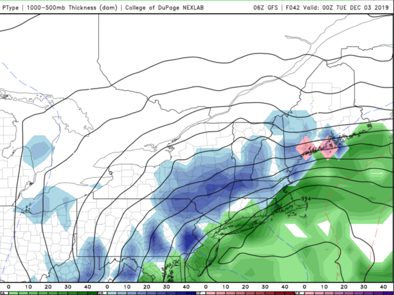
NAM valid 7pm tomorrow
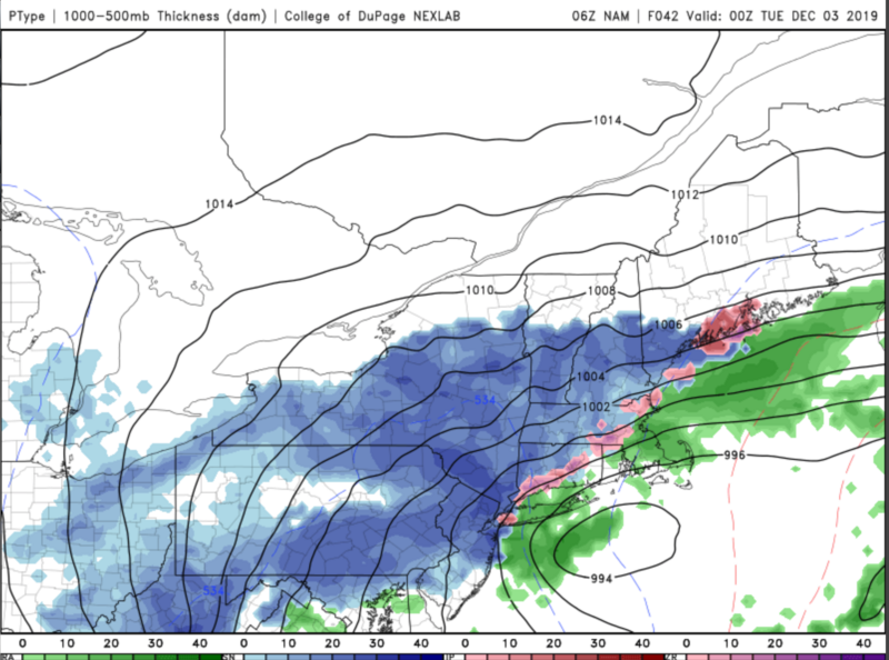
A difference could be how the ULL is positioned. The NAM has it closer to the coast and wrapped tightly whereas the GFS is further east and more 'open' allowing UL energy to escape. The model handling the ULL - upper level low - most accurately will end up a champion.
_________________
_______________________________________________________________________________________________________
CLICK HERE to view NJ Strong Snowstorm Classifications
Frank_Wx- Godzilla Seeker
- Posts : 21305
Reputation : 328
Join date : 2013-01-05
Age : 32
Location : Jersey City, NJ -
Re: December 1st-2nd Winter Storm
![]() by Frank_Wx Sun Dec 01, 2019 10:24 am
by Frank_Wx Sun Dec 01, 2019 10:24 am

_________________
_______________________________________________________________________________________________________
CLICK HERE to view NJ Strong Snowstorm Classifications
Frank_Wx- Godzilla Seeker
- Posts : 21305
Reputation : 328
Join date : 2013-01-05
Age : 32
Location : Jersey City, NJ -
Re: December 1st-2nd Winter Storm
![]() by Frank_Wx Sun Dec 01, 2019 10:38 am
by Frank_Wx Sun Dec 01, 2019 10:38 am
_________________
_______________________________________________________________________________________________________
CLICK HERE to view NJ Strong Snowstorm Classifications
Frank_Wx- Godzilla Seeker
- Posts : 21305
Reputation : 328
Join date : 2013-01-05
Age : 32
Location : Jersey City, NJ -
Re: December 1st-2nd Winter Storm
![]() by Vinnydula Sun Dec 01, 2019 10:46 am
by Vinnydula Sun Dec 01, 2019 10:46 am

Vinnydula- Pro Enthusiast
- Posts : 778
Reputation : 8
Join date : 2013-12-12
Location : Dobbs ferry
Re: December 1st-2nd Winter Storm
![]() by amugs Sun Dec 01, 2019 10:49 am
by amugs Sun Dec 01, 2019 10:49 am
_________________
Mugs
AKA:King: Snow Weenie
Self Proclaimed
WINTER 2014-15 : 55.12" +.02 for 6 coatings (avg. 35")
WINTER 2015-16 Total - 29.8" (Avg 35")
WINTER 2016-17 : 39.5" so far
amugs- Advanced Forecaster - Mod
- Posts : 15095
Reputation : 213
Join date : 2013-01-07
Age : 54
Location : Hillsdale,NJ
Page 4 of 5 • 1, 2, 3, 4, 5 ![]()
|
|
|