December 1st-2nd Winter Storm Observations
+50
crippo84
SkiSeadooJoe
emokid51783
essexcountypete
dsix85
dsvinos
deadrabbit79
lglickman1
SENJsnowman
nutleyblizzard
skinsfan1177
Artechmetals
2004blackwrx
DAYBLAZER
sroc4
larryrock72
Joe Snow
Sanchize06
jimv45
SoulSingMG
snowday111
brownie
Math23x7
Scullybutcher
Fededle22
bobjohnsonforthehall
GreyBeard
Irish
TheAresian
RJB8525
frank 638
amugs
mikeypizano
billg315
CPcantmeasuresnow
heehaw453
weatherwatchermom
algae888
hyde345
Grselig
1190ftalt
Zhukov1945
Radz
dkodgis
Dunnzoo
docstox12
aiannone
Vinnydula
jmanley32
Frank_Wx
54 posters
Page 5 of 22
Page 5 of 22 •  1, 2, 3, 4, 5, 6 ... 13 ... 22
 Re: December 1st-2nd Winter Storm Observations
24, sleet and snow. 1 inch so far.
hyde345- Pro Enthusiast

- Posts : 1082
Join date : 2013-01-08
 Re: December 1st-2nd Winter Storm Observations
Temp up to 31.1° with light rain. Roads are a mess.
Dunnzoo- Senior Enthusiast - Mod

- Posts : 4905
Join date : 2013-01-11
 Re: December 1st-2nd Winter Storm Observations
nothing going on right now..temp up to 36

weatherwatchermom- Senior Enthusiast

- Posts : 3793
Reputation : 78
Join date : 2014-11-25
Location : Hazlet Township, NJ
 Re: December 1st-2nd Winter Storm Observations
35* and raining here. Frozen stuff ended about an hour ago - which is good because it was getting icy. Rest of the precip for my area should be rain until late morning tomorrow. Then let’s see what happens.

billg315- Advanced Forecaster - Mod

- Posts : 4483
Reputation : 185
Join date : 2015-01-24
Age : 50
Location : Flemington, NJ
 Re: December 1st-2nd Winter Storm Observations
Sleet has ended cloudy now Ended up with a coating of sleet
frank 638- Senior Enthusiast

- Posts : 2843
Reputation : 37
Join date : 2016-01-01
Age : 40
Location : bronx ny
 Re: December 1st-2nd Winter Storm Observations
bobjohnsonforthehall wrote:Quick meteorological question. If we are looking at a deformation band somewhere in the area tomorrow, won't that also cause areas around it to possibly become areas to receive less than they would have as the deformation band sucks the moisture form an area around it?
Yes, what you’re referring to is sinking air. When air rises - a result of deformation - atmosphere needs to balance it with sinking air somewhere else so areas around the deform zone are dry slotted.
_________________
_______________________________________________________________________________________________________
CLICK HERE to view NJ Strong Snowstorm Classifications
 Re: December 1st-2nd Winter Storm Observations
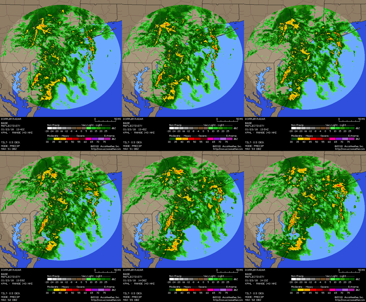
Lots of precip still working it’s way thru. No one was expected to see consistent snowfall today. I guessed some areas could get 1-2”. I got just less than an inch in Morristown.

_________________
_______________________________________________________________________________________________________
CLICK HERE to view NJ Strong Snowstorm Classifications
 Re: December 1st-2nd Winter Storm Observations
What a BRUTAL dry slot on latest model runs from NENJ, NYC, LI into CT.

As mentioned in my discussion this happens when the mid leve centers travel along the coast instead of off the coast.

As mentioned in my discussion this happens when the mid leve centers travel along the coast instead of off the coast.
_________________
_______________________________________________________________________________________________________
CLICK HERE to view NJ Strong Snowstorm Classifications
 Re: December 1st-2nd Winter Storm Observations
I have been sitting at my dining room table working most of the day, and observing through my window. Started here as sleet around 9:30 this morning, bouncing off the roof. Switched over to snow sometime later in the morning - pretty, quiet flakes. I’m not sure if it’s doing anything at all right now, but it is very dark and there is a glaze on everything. Driveway, front walk, and street are coated, grass not so much. I don’t think it’s measurable yet.
I am on a mountain, so my observations are often quite different from those a mile down the highway.
I have the Christmas tree on, have my outside Christmas lights on, and a fire going in the fireplace (gave up on work about an hour ago), and I can pretend it’s actually closer to Dec. 25.
Bring it on. I am psyched for a winter storm with substantial snow!
brownie- Posts : 393
Reputation : 17
Join date : 2013-11-10
Location : Parsippany, NJ
 Re: December 1st-2nd Winter Storm Observations
Deform band over EPA and central/western NJ
.png.c1a549cffa3a2ed8c2c06b39d077e989.png)
.png.c1a549cffa3a2ed8c2c06b39d077e989.png)
_________________
_______________________________________________________________________________________________________
CLICK HERE to view NJ Strong Snowstorm Classifications
 Re: December 1st-2nd Winter Storm Observations
Just hit 32.2° and have light rain. Temps have been climbing the last 90 minutes
_________________
Janet
Snowfall winter of 2023-2024 17.5"
Snowfall winter of 2022-2023 6.0"
Snowfall winter of 2021-2022 17.6" 1" sleet 2/25/22
Snowfall winter of 2020-2021 51.1"
Snowfall winter of 2019-2020 8.5"
Snowfall winter of 2018-2019 25.1"
Snowfall winter of 2017-2018 51.9"
Snowfall winter of 2016-2017 45.6"
Snowfall winter of 2015-2016 29.5"
Snowfall winter of 2014-2015 50.55"
Snowfall winter of 2013-2014 66.5"
Dunnzoo- Senior Enthusiast - Mod

- Posts : 4905
Reputation : 68
Join date : 2013-01-11
Age : 62
Location : Westwood, NJ
 Re: December 1st-2nd Winter Storm Observations
Frank do you still think 4-8 in the areas you painted? These new model runs are very disconcerting for westchester.Frank_Wx wrote:Deform band over EPA and central/western NJ

jmanley32- Senior Enthusiast

- Posts : 20535
Reputation : 108
Join date : 2013-12-12
Age : 43
Location : Yonkers, NY
 Re: December 1st-2nd Winter Storm Observations
NWS Mount Holly just upgraded Central and NW NJ to a Winter Storm Warning for 4-6” and locally higher amounts tomorrow:
WINTER STORM WARNING IN EFFECT FROM 6 AM MONDAY TO 4 AM ESTTUESDAY
* WHAT...Heavy snow expected. Total snow accumulations of 4 to 6 inches.
* WHERE...In New Jersey, Hunterdon, Somerset and Mercer
counties. In Pennsylvania, Upper Bucks and Lower Bucks
counties.
* WHEN...From 6 AM Monday to 4 AM EST Tuesday.
* IMPACTS...Travel will be very difficult. The hazardous
conditions will impact the morning and evening commute.
* ADDITIONAL DETAILS...Lingering rain overnight will mix with snow or sleet and change over to all snow around daybreak Monday morning. Snow will last for several hours on Monday before dissipating into the late evening hours. Snow accumulations of 4 to 6 inches are expected with localized higher amounts possible under heavier bands that develop.

billg315- Advanced Forecaster - Mod

- Posts : 4483
Reputation : 185
Join date : 2015-01-24
Age : 50
Location : Flemington, NJ
 Re: December 1st-2nd Winter Storm Observations
If this unfolds the way Frank 's graphic shows I'll take that 9.9 inches right over my area for sure!

Irish- Pro Enthusiast

- Posts : 788
Reputation : 19
Join date : 2019-01-16
Age : 45
Location : Old Bridge, NJ
 Re: December 1st-2nd Winter Storm Observations
Scott -
That will mean a delay for sure on Tuesday!
That will mean a delay for sure on Tuesday!
snowday111- Posts : 92
Reputation : 1
Join date : 2013-01-07
Location : Monroe Twp. NJ (Middlesex County)

SoulSingMG- Senior Enthusiast

- Posts : 2853
Reputation : 74
Join date : 2013-12-11
Location : Long Island City, NY
 Re: December 1st-2nd Winter Storm Observations
26 here. It went back to icing. Slop is totaling 3 large
Last edited by dkodgis on Sun Dec 01, 2019 4:33 pm; edited 1 time in total

dkodgis- Senior Enthusiast

- Posts : 2560
Reputation : 98
Join date : 2013-12-29

jmanley32- Senior Enthusiast

- Posts : 20535
Reputation : 108
Join date : 2013-12-12
Age : 43
Location : Yonkers, NY
 Re: December 1st-2nd Winter Storm Observations
Not a lot going on yet but I expect that to change tonight and tomorrow with the forecast of around a foot.
jimv45- Senior Enthusiast

- Posts : 1168
Reputation : 36
Join date : 2013-09-20
Location : Hopewell jct.
 Re: December 1st-2nd Winter Storm Observations
Good news for people near the coast, 18z models seems to have bumped back east.
RGEM


RGEM


Sanchize06- Senior Enthusiast

- Posts : 1041
Reputation : 21
Join date : 2013-02-05
Location : Union Beach, NJ
 Re: December 1st-2nd Winter Storm Observations
Wow, i woke up to the forecast saying an inch and now models are showing anywhere from 6-12?!

Irish- Pro Enthusiast

- Posts : 788
Reputation : 19
Join date : 2019-01-16
Age : 45
Location : Old Bridge, NJ

SoulSingMG- Senior Enthusiast

- Posts : 2853
Reputation : 74
Join date : 2013-12-11
Location : Long Island City, NY
 Re: December 1st-2nd Winter Storm Observations
pouring out..temp went up to 40 high for the day. we just had advisory's posted...small craft, flooding and winter weather... they are saying 1-3 right now for tom into Tues.

weatherwatchermom- Senior Enthusiast

- Posts : 3793
Reputation : 78
Join date : 2014-11-25
Location : Hazlet Township, NJ
 Re: December 1st-2nd Winter Storm Observations
Amounts across much central/north NJ seem to be trending up in models and forecasts. It appears consensus is building, as Frank projected hours ago, around this trough or deformation band setting up over the state tomorrow. I’m increasingly feeling good about many of our chances to hit 6”-plus tomorrow.

billg315- Advanced Forecaster - Mod

- Posts : 4483
Reputation : 185
Join date : 2015-01-24
Age : 50
Location : Flemington, NJ
 Re: December 1st-2nd Winter Storm Observations
ha ha...I saw the same even here on the water the models say more than the advisory just posted...lets see if we get a surprise tomorrowIrish wrote:Wow, i woke up to the forecast saying an inch and now models are showing anywhere from 6-12?!

weatherwatchermom- Senior Enthusiast

- Posts : 3793
Reputation : 78
Join date : 2014-11-25
Location : Hazlet Township, NJ
 Re: December 1st-2nd Winter Storm Observations
billg315 wrote:Amounts across much central/north NJ seem to be trending up in models and forecasts. It appears consensus is building, as Frank projected hours ago, around this trough or deformation band setting up over the state tomorrow. I’m increasingly feeling good about many of our chances to hit 6”-plus tomorrow.
Do we think forecasted temps are likely too high or is this one of those "snow so hard that it overcomes temps" types of events. Hopefully the former as the latter don't seem to work out too often,

Zhukov1945- Posts : 138
Reputation : 8
Join date : 2018-03-21
Location : Clinton Township NJ
 Re: December 1st-2nd Winter Storm Observations
25 with snow and sleet, about 2 inches OTG.

hyde345- Pro Enthusiast

- Posts : 1082
Reputation : 48
Join date : 2013-01-08
Location : Hyde Park, NY
Page 5 of 22 •  1, 2, 3, 4, 5, 6 ... 13 ... 22
Page 5 of 22
Permissions in this forum:
You cannot reply to topics in this forum|
|
|

 Home
Home
