February 5th Updated Snow Map / Discussions 3.0
+28
SoulSingMG
SurfNJ
H.G. Rising
snemiroff
WOLVES1
elkiehound
amugs
jmanley32
geigere1
cooladi
jtswife
sroc4
skinsfan1177
sabamfa
oldtimer
2004blackwrx
CPcantmeasuresnow
aiannone
algae888
SNOW MAN
deadrabbit79
NjWeatherGuy
docstox12
Yschiff
pdubz
jimv45
nancy-j-s
Frank_Wx
32 posters
Page 5 of 8 •  1, 2, 3, 4, 5, 6, 7, 8
 Re: February 5th Updated Snow Map / Discussions 3.0
jimv45 wrote:I wish everyone got big snows with this storm but up here In the mid-Hudson Valley we got the shaft on the last 3 big snows so 6-12 for us up here was long time waiting!
Enjoy it!
NjWeatherGuy- Advanced Forecaster

- Posts : 4100
Join date : 2013-01-06
 Re: February 5th Updated Snow Map / Discussions 3.0
The lack of clarity in official forecasts for the potential for ice is worrying me quite a bit. I've seen a number of storms with ice components and it truly doesn't take much ice at all to turn things treacherous. I'm predicting the NYC Mayor will have schools open tomorrow nevertheless, after all, he did drop the groundhog!
cooladi- Pro Enthusiast

- Posts : 185
Join date : 2013-01-08
 Re: February 5th Updated Snow Map / Discussions 3.0
The funny thing this winter my kids and I like to snow tube and we have to go south for the most part to get some good snows!! been an I-95 winter!
jimv45- Senior Enthusiast

- Posts : 1168
Reputation : 36
Join date : 2013-09-20
Location : Hopewell jct.
 Re: February 5th Updated Snow Map / Discussions 3.0
cooladi wrote:The lack of clarity in official forecasts for the potential for ice is worrying me quite a bit. I've seen a number of storms with ice components and it truly doesn't take much ice at all to turn things treacherous. I'm predicting the NYC Mayor will have schools open tomorrow nevertheless, after all, he did drop the groundhog!
I'm not as concerned for ice in the city, surface temps will likely rise above freezing here in addition urban heat influence and heavy salt treating on most surfaces I'm not all too worried. I'm more worried out in the far western suburbs of NYC and the far NW suburbs of Philly where surface temperatures have the potential to be below freezing during most of the event and less treated surfaces and no ocean or urban heat influence, it could be a problem in these areas.
NjWeatherGuy- Advanced Forecaster

- Posts : 4100
Reputation : 28
Join date : 2013-01-06
Location : Belle Mead, NJ
 Re: February 5th Updated Snow Map / Discussions 3.0
Well none of us can really complain considering it will be a few more inches on top of what we have with temps dropping to low double digits and some single digits in the area after the storm and there's another on the horizon. I just wish it was Saturday and not Sunday into Monday b

HectorO- Pro Enthusiast

- Posts : 959
Reputation : 27
Join date : 2013-01-11
 Re: February 5th Updated Snow Map / Discussions 3.0
You think the snow pack will survive on LI. I have a good 9" on the ground hoping it will last through heavy rain.

tigernumba1- Posts : 298
Reputation : 1
Join date : 2013-11-22
Age : 29
Location : East Northport, NY, 11731
 Re: February 5th Updated Snow Map / Discussions 3.0
Yeah I was trying to do it so the loop was in the actual thread instead of having to click the link
http://earth.nullschool.net/#current/wind/isobaric/500hPa/orthographic=-85.63,35.00,1024
http://earth.nullschool.net/#current/wind/isobaric/500hPa/orthographic=-85.63,35.00,1024
Last edited by sroc4 on Tue Feb 04, 2014 2:52 pm; edited 2 times in total
_________________
"In weather and in life, there's no winning and losing; there's only winning and learning."
WINTER 2012/2013 TOTALS 43.65"WINTER 2017/2018 TOTALS 62.85" WINTER 2022/2023 TOTALS 4.9"
WINTER 2013/2014 TOTALS 64.85"WINTER 2018/2019 TOTALS 14.25" WINTER 2023/2024 TOTALS 13.1"
WINTER 2014/2015 TOTALS 71.20"WINTER 2019/2020 TOTALS 6.35"
WINTER 2015/2016 TOTALS 35.00"WINTER 2020/2021 TOTALS 37.75"
WINTER 2016/2017 TOTALS 42.25"WINTER 2021/2022 TOTALS 31.65"

sroc4- Admin

- Posts : 8331
Reputation : 301
Join date : 2013-01-07
Location : Wading River, LI
 Re: February 5th Updated Snow Map / Discussions 3.0
tigernumba1 wrote:You think the snow pack will survive on LI. I have a good 9" on the ground hoping it will last through heavy rain.
The couple inches of front end snow will help out, the snowpack will condense with rain and then freeze into an ice sheet of sorts after the storm passes.

NjWeatherGuy- Advanced Forecaster

- Posts : 4100
Reputation : 28
Join date : 2013-01-06
Location : Belle Mead, NJ
 Re: February 5th Updated Snow Map / Discussions 3.0
SROC picture not showing up.

NjWeatherGuy- Advanced Forecaster

- Posts : 4100
Reputation : 28
Join date : 2013-01-06
Location : Belle Mead, NJ
 Re: February 5th Updated Snow Map / Discussions 3.0
sroc4 wrote:Yeah I was trying to do it so the loop was in the actual thread instead of having to click the link
http://earth.nullschool.net/#current/wind/isobaric/500hPa/orthographic=-85.63,35.00,1024
_________________
"In weather and in life, there's no winning and losing; there's only winning and learning."
WINTER 2012/2013 TOTALS 43.65"WINTER 2017/2018 TOTALS 62.85" WINTER 2022/2023 TOTALS 4.9"
WINTER 2013/2014 TOTALS 64.85"WINTER 2018/2019 TOTALS 14.25" WINTER 2023/2024 TOTALS 13.1"
WINTER 2014/2015 TOTALS 71.20"WINTER 2019/2020 TOTALS 6.35"
WINTER 2015/2016 TOTALS 35.00"WINTER 2020/2021 TOTALS 37.75"
WINTER 2016/2017 TOTALS 42.25"WINTER 2021/2022 TOTALS 31.65"

sroc4- Admin

- Posts : 8331
Reputation : 301
Join date : 2013-01-07
Location : Wading River, LI
 Re: February 5th Updated Snow Map / Discussions 3.0
You can see where it's going to steer and it doesn't look pretty.

NjWeatherGuy- Advanced Forecaster

- Posts : 4100
Reputation : 28
Join date : 2013-01-06
Location : Belle Mead, NJ
 Re: February 5th Updated Snow Map / Discussions 3.0
Wow that SW fetch
oldtimer- Senior Enthusiast

- Posts : 1103
Reputation : 14
Join date : 2013-01-16
Age : 78
Location : Port Jefferson Station Suffolk County
 Re: February 5th Updated Snow Map / Discussions 3.0
So today I noticed a couple things:
1. Snow pack helped keep our temperatures colder
2. Short range models increasing the ice threat and lessening the rain threat
I think we have to seriously start worrying about ICE before snow or rain in my opinion. This could get bad.
Will have both a SNOW and ICE map out by 5pm!!
1. Snow pack helped keep our temperatures colder
2. Short range models increasing the ice threat and lessening the rain threat
I think we have to seriously start worrying about ICE before snow or rain in my opinion. This could get bad.
Will have both a SNOW and ICE map out by 5pm!!
_________________
_______________________________________________________________________________________________________
CLICK HERE to view NJ Strong Snowstorm Classifications
 Re: February 5th Updated Snow Map / Discussions 3.0
Frank_Wx wrote:So today I noticed a couple things:
1. Snow pack helped keep our temperatures colder
2. Short range models increasing the ice threat and lessening the rain threat
I think we have to seriously start worrying about ICE before snow or rain in my opinion. This could get bad.
Will have both a SNOW and ICE map out by 5pm!!
Agree, I'm having issues trying to pinpoint amounts because models are all over the place, NAM says 1" of ice meanwhile the last SREF run I saw says quick over to rain except for I-80 north. This is a headache.

NjWeatherGuy- Advanced Forecaster

- Posts : 4100
Reputation : 28
Join date : 2013-01-06
Location : Belle Mead, NJ
 Re: February 5th Updated Snow Map / Discussions 3.0
NjWeatherGuy wrote:Frank_Wx wrote:So today I noticed a couple things:
1. Snow pack helped keep our temperatures colder
2. Short range models increasing the ice threat and lessening the rain threat
I think we have to seriously start worrying about ICE before snow or rain in my opinion. This could get bad.
Will have both a SNOW and ICE map out by 5pm!!
Agree, I'm having issues trying to pinpoint amounts because models are all over the place, NAM says 1" of ice meanwhile the last SREF run I saw says quick over to rain except for I-80 north. This is a headache.
This is by far the hardest forecast of the season.
_________________
_______________________________________________________________________________________________________
CLICK HERE to view NJ Strong Snowstorm Classifications
 Re: February 5th Updated Snow Map / Discussions 3.0
where will this ice threat be? should northern L.I worry about it also
pdubz- Pro Enthusiast

- Posts : 539
Reputation : 0
Join date : 2013-09-24
Age : 32
Location : Port Washington,NY (L.I)
 Re: February 5th Updated Snow Map / Discussions 3.0
Frank_Wx wrote:NjWeatherGuy wrote:Frank_Wx wrote:So today I noticed a couple things:
1. Snow pack helped keep our temperatures colder
2. Short range models increasing the ice threat and lessening the rain threat
I think we have to seriously start worrying about ICE before snow or rain in my opinion. This could get bad.
Will have both a SNOW and ICE map out by 5pm!!
Agree, I'm having issues trying to pinpoint amounts because models are all over the place, NAM says 1" of ice meanwhile the last SREF run I saw says quick over to rain except for I-80 north. This is a headache.
This is by far the hardest forecast of the season.
By far, good chance we see every winter p-type with this.

NjWeatherGuy- Advanced Forecaster

- Posts : 4100
Reputation : 28
Join date : 2013-01-06
Location : Belle Mead, NJ
 Re: February 5th Updated Snow Map / Discussions 3.0
Frank where are we talking about the worst freezing rain, I noticed on the other thread the last map made by someone had me right in the crosshalrs of the sig icing. Do we expect alot of power outages north of NYC, like southern WC and lower hudson valley? I am not sure if your last post was talking about NJ or my area too. Thx

jmanley32- Senior Enthusiast

- Posts : 20513
Reputation : 108
Join date : 2013-12-12
Age : 42
Location : Yonkers, NY
 Re: February 5th Updated Snow Map / Discussions 3.0
Upton still has less than .15 for most areas, have not changed snowfall still has lower areas in 6-8. 0.15 or less that isnt that serious, enough to make it slippery but not crippling. Do you guys think this will be upped later tonight?

jmanley32- Senior Enthusiast

- Posts : 20513
Reputation : 108
Join date : 2013-12-12
Age : 42
Location : Yonkers, NY
 Re: February 5th Updated Snow Map / Discussions 3.0
jmanley32 wrote:Frank where are we talking about the worst freezing rain, I noticed on the other thread the last map made by someone had me right in the crosshalrs of the sig icing. Do we expect alot of power outages north of NYC, like southern WC and lower hudson valley? I am not sure if your last post was talking about NJ or my area too. Thx
I assuming you're talking about my map, from what I have seen on models most of the ice will be in west central NJ, far less amounts into NY. The map was made mostly for NJ and NYC area, not perfect outside those areas in lower upstate and western side of my map in PA.

NjWeatherGuy- Advanced Forecaster

- Posts : 4100
Reputation : 28
Join date : 2013-01-06
Location : Belle Mead, NJ
 Re: February 5th Updated Snow Map / Discussions 3.0
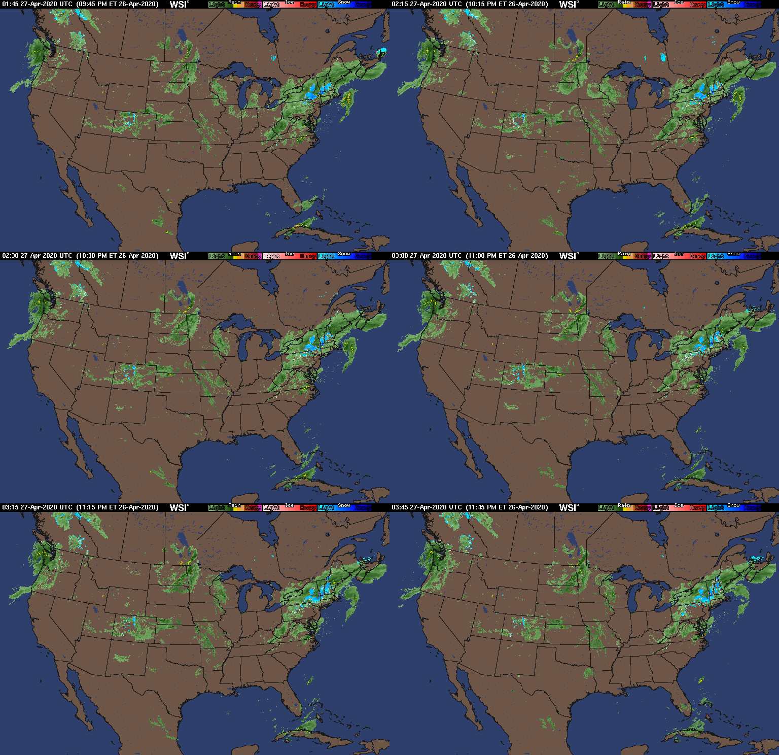
Tom the current 500mb steering looks bad now but if you look at the current surface map there is potent arctic HP on the heals of the trough up in NW and NCentral Canada. 1048-1035mb filtering in dense cold arctic air. If that combined with the cold front currently draped north of the great lakes can push on south just a bit and remain strong one could make the argument that the LP currently in SE Tx would follow along the stationary front and begin to transfer somewhere around the WVa/Va boarder off SNJ instead of Central NJ. Without question the ice is going to be what's remembered about this storm for most of our area.
[img] [/img]
[img]
 [/img]
_________________
"In weather and in life, there's no winning and losing; there's only winning and learning."
WINTER 2012/2013 TOTALS 43.65"WINTER 2017/2018 TOTALS 62.85" WINTER 2022/2023 TOTALS 4.9"
WINTER 2013/2014 TOTALS 64.85"WINTER 2018/2019 TOTALS 14.25" WINTER 2023/2024 TOTALS 13.1"
WINTER 2014/2015 TOTALS 71.20"WINTER 2019/2020 TOTALS 6.35"
WINTER 2015/2016 TOTALS 35.00"WINTER 2020/2021 TOTALS 37.75"
WINTER 2016/2017 TOTALS 42.25"WINTER 2021/2022 TOTALS 31.65"

sroc4- Admin

- Posts : 8331
Reputation : 301
Join date : 2013-01-07
Location : Wading River, LI
 Re: February 5th Updated Snow Map / Discussions 3.0
a few things about tonights storm. if we are going to get 6" of snow its has to snow heavy from the start. by 7am or so the warm air in the mid levels are going to take over. but 6" is still a possibility for nyc metro LI eastern nj. as far as the fz rain I think its going to be very bad from the Bronx north Bergen co. on west and even the north shore of the island. first of all forget about manhattan, they should have a forecast for themselves. fz rain wont affect them. yesterday a friend of mine who works in midtown said there was no snow on the street or sidewalks yet when she went home to Astoria, queens, just across the river, seven inches on the ground. manhattan is a heat island. the surface temps in the areas I mentioned will not get above freezing. why? temps right now are at 32* and the cloud cover is very light. with the snow pack and light winds these places will drop off quickly and lower than guidance. once the precip starts temps will fall a few degrees more. so we are looking at temps in the mid 20's at night with a fresh snowpack. the other factor is the surface winds tonight and tomorrow will be from the NE and more importantly very light under ten miles per hour even calm at some point. SST are at their lowest of the winter and the ground is cold. their is nothing IMO that can push up surface temps past 32*. so I see a mostly frozen solution with a little rain or drizzle midday or tom. afternoon. BTW 18z nam colder and low transfers quicker.

algae888- Advanced Forecaster

- Posts : 5311
Reputation : 46
Join date : 2013-02-05
Age : 61
Location : mt. vernon, new york
 Re: February 5th Updated Snow Map / Discussions 3.0
NjWeatherGuy wrote:Frank_Wx wrote:So today I noticed a couple things:
1. Snow pack helped keep our temperatures colder
2. Short range models increasing the ice threat and lessening the rain threat
I think we have to seriously start worrying about ICE before snow or rain in my opinion. This could get bad.
Will have both a SNOW and ICE map out by 5pm!!
Agree, I'm having issues trying to pinpoint amounts because models are all over the place, NAM says 1" of ice meanwhile the last SREF run I saw says quick over to rain except for I-80 north. This is a headache.
NJ this is what I was saying yesterday about this storm is that the ice component for us in NNJ is going to be well almost paralyzing with power outages - we are in for a bad one - just wish it would be all snow instead of ice - this will cause MAJOR issues up here - remember this as well that towns are running low on salt due to the severity of the winter so far and will be almost or exhausted tom of their supplies so the will only salt primary roads - spoke with four people today in DPW and police chiefs up here that I know who contacted me about the forecast. The towns are concerned as is PSE&G and JCP&L. Not good folks - trending ice.
_________________
Mugs
AKA:King: Snow Weenie
Self Proclaimed
WINTER 2014-15 : 55.12" +.02 for 6 coatings (avg. 35")
WINTER 2015-16 Total - 29.8" (Avg 35")
WINTER 2016-17 : 39.5" so far

amugs- Advanced Forecaster - Mod

- Posts : 15093
Reputation : 213
Join date : 2013-01-07
Age : 54
Location : Hillsdale,NJ
 Re: February 5th Updated Snow Map / Discussions 3.0
algae888 wrote:a few things about tonights storm. if we are going to get 6" of snow its has to snow heavy from the start. by 7am or so the warm air in the mid levels are going to take over. but 6" is still a possibility for nyc metro LI eastern nj. as far as the fz rain I think its going to be very bad from the Bronx north Bergen co. on west and even the north shore of the island. first of all forget about manhattan, they should have a forecast for themselves. fz rain wont affect them. yesterday a friend of mine who works in midtown said there was no snow on the street or sidewalks yet when she went home to Astoria, queens, just across the river, seven inches on the ground. manhattan is a heat island. the surface temps in the areas I mentioned will not get above freezing. why? temps right now are at 32* and the cloud cover is very light. with the snow pack and light winds these places will drop off quickly and lower than guidance. once the precip starts temps will fall a few degrees more. so we are looking at temps in the mid 20's at night with a fresh snowpack. the other factor is the surface winds tonight and tomorrow will be from the NE and more importantly very light under ten miles per hour even calm at some point. SST are at their lowest of the winter and the ground is cold. their is nothing IMO that can push up surface temps past 32*. so I see a mostly frozen solution with a little rain or drizzle midday or tom. afternoon. BTW 18z nam colder and low transfers quicker.
Great summary, thank you.
_________________
_______________________________________________________________________________________________________
CLICK HERE to view NJ Strong Snowstorm Classifications
 Re: February 5th Updated Snow Map / Discussions 3.0
YIKES!


_________________
_______________________________________________________________________________________________________
CLICK HERE to view NJ Strong Snowstorm Classifications
 Re: February 5th Updated Snow Map / Discussions 3.0
NJ I am very close to NYC, just barely north of the Bx. SO I dunno seems like its borderline.

jmanley32- Senior Enthusiast

- Posts : 20513
Reputation : 108
Join date : 2013-12-12
Age : 42
Location : Yonkers, NY
 Re: February 5th Updated Snow Map / Discussions 3.0
Frank_Wx wrote:YIKES!
That's one bulleye I want no part of.

NjWeatherGuy- Advanced Forecaster

- Posts : 4100
Reputation : 28
Join date : 2013-01-06
Location : Belle Mead, NJ
Page 5 of 8 •  1, 2, 3, 4, 5, 6, 7, 8
Permissions in this forum:
You cannot reply to topics in this forum|
|
|

 Home
Home