
 Search
Dec 16-17 Snow/Ice potential storm
Page 4 of 11 •  1, 2, 3, 4, 5 ... 9, 10, 11
 ![]()
Re: Dec 16-17 Snow/Ice potential storm
![]() by Irish Sun Dec 15, 2019 9:48 pm
by Irish Sun Dec 15, 2019 9:48 pm
1 of 2
Action Recommended
Execute a pre-planned activity identified in the instructions
Issued By
Philadelphia - PA, US, National Weather Service
Affected Area
Portions of central, northern and northwest New Jersey and east central and southeast Pennsylvania
Description
...WINTER WEATHER ADVISORY REMAINS IN EFFECT FROM 1 PM MONDAY TO 7 AM EST TUESDAY...
WHAT...Mixed precipitation expected. Total snow accumulations of up to one inch and ice accumulations of up to two tenths of an inch.
WHERE...Portions of central, northern and northwest New Jersey and east central and southeast Pennsylvania.
WHEN...From 1 PM Monday to 7 AM EST Tuesday.
IMPACTS...Plan on slippery road conditions. The hazardous conditions could impact the Monday evening commute.
ADDITIONAL DETAILS...Snow begins Monday morning and then will mix with sleet and freezing rain Monday afternoon. Precipitation then changes to plain rain Monday night. Rain then continues through Tuesday before tapering off Tuesday night.
Irish- Pro Enthusiast

- Posts : 788
Join date : 2019-01-16
Re: Dec 16-17 Snow/Ice potential storm
![]() by amugs Sun Dec 15, 2019 10:05 pm
by amugs Sun Dec 15, 2019 10:05 pm
If people follow this they and these maps like the Euro and NAM come to fruition there will be many unhappy peeps.
amugs- Advanced Forecaster - Mod

- Posts : 15095
Join date : 2013-01-07
Re: Dec 16-17 Snow/Ice potential storm
![]() by bobjohnsonforthehall Sun Dec 15, 2019 10:09 pm
by bobjohnsonforthehall Sun Dec 15, 2019 10:09 pm

bobjohnsonforthehall- Posts : 311
Reputation : 19
Join date : 2016-10-02
Location : Flemington NJ
Re: Dec 16-17 Snow/Ice potential storm
![]() by Irish Sun Dec 15, 2019 10:29 pm
by Irish Sun Dec 15, 2019 10:29 pm

Irish- Pro Enthusiast
- Posts : 788
Reputation : 19
Join date : 2019-01-16
Age : 45
Location : Old Bridge, NJ
Re: Dec 16-17 Snow/Ice potential storm
![]() by amugs Sun Dec 15, 2019 10:38 pm
by amugs Sun Dec 15, 2019 10:38 pm
_________________
Mugs
AKA:King: Snow Weenie
Self Proclaimed
WINTER 2014-15 : 55.12" +.02 for 6 coatings (avg. 35")
WINTER 2015-16 Total - 29.8" (Avg 35")
WINTER 2016-17 : 39.5" so far

amugs- Advanced Forecaster - Mod
- Posts : 15095
Reputation : 213
Join date : 2013-01-07
Age : 54
Location : Hillsdale,NJ
Re: Dec 16-17 Snow/Ice potential storm
![]() by algae888 Mon Dec 16, 2019 5:15 am
by algae888 Mon Dec 16, 2019 5:15 am

algae888- Advanced Forecaster

- Posts : 5311
Reputation : 46
Join date : 2013-02-05
Age : 62
Location : mt. vernon, new york
Re: Dec 16-17 Snow/Ice potential storm
![]() by jmanley32 Mon Dec 16, 2019 6:01 am
by jmanley32 Mon Dec 16, 2019 6:01 am


jmanley32- Senior Enthusiast

- Posts : 20535
Reputation : 108
Join date : 2013-12-12
Age : 43
Location : Yonkers, NY
Re: Dec 16-17 Snow/Ice potential storm
![]() by jmanley32 Mon Dec 16, 2019 6:10 am
by jmanley32 Mon Dec 16, 2019 6:10 am

jmanley32- Senior Enthusiast
- Posts : 20535
Reputation : 108
Join date : 2013-12-12
Age : 43
Location : Yonkers, NY
Re: Dec 16-17 Snow/Ice potential storm
![]() by docstox12 Mon Dec 16, 2019 6:14 am
by docstox12 Mon Dec 16, 2019 6:14 am

docstox12- Wx Statistician Guru

- Posts : 8530
Reputation : 222
Join date : 2013-01-07
Age : 73
Location : Monroe NY
Re: Dec 16-17 Snow/Ice potential storm
![]() by jmanley32 Mon Dec 16, 2019 6:15 am
by jmanley32 Mon Dec 16, 2019 6:15 am
jmanley32- Senior Enthusiast
- Posts : 20535
Reputation : 108
Join date : 2013-12-12
Age : 43
Location : Yonkers, NY
Re: Dec 16-17 Snow/Ice potential storm
![]() by heehaw453 Mon Dec 16, 2019 7:18 am
by heehaw453 Mon Dec 16, 2019 7:18 am
jmanley32 wrote:Al, SR models are taking this till about 7pm Tuesday from what I can see, not just 7am. Anyways yes we look to be back to 2-5 inches of snow (except 3km nam which has snow confined to northern areas) and then ice ice babay! Yikes! Snow encased in ice be ready to lose some power if these numbers are correct, trees are going to be sagging like crazy. There is now a HWO for the coastal areas saying WWA will likely be needed, with the ice shown we may need ice storm warnings too, it will be interesting to see if freezing rain really persists that long, hoping we do see at least some snow.
Ths hrdps is out to lunch and i wouldn't regard it as reliable in terms of ice. Check out the disparity of surface temps from what was progged to reality. Those that are at and above the baroclinic zone (area separating warm/cold mid level temps) can can 2"+ of snow out of this. I would say above route 80 best shot at that. I would also say those are the areas which should be most concerned about the ice.


heehaw453- Advanced Forecaster
- Posts : 3906
Reputation : 86
Join date : 2014-01-20
Location : Bedminster Township, PA Elevation 600' ASL
Re: Dec 16-17 Snow/Ice potential storm
![]() by heehaw453 Mon Dec 16, 2019 7:23 am
by heehaw453 Mon Dec 16, 2019 7:23 am

heehaw453- Advanced Forecaster
- Posts : 3906
Reputation : 86
Join date : 2014-01-20
Location : Bedminster Township, PA Elevation 600' ASL
Re: Dec 16-17 Snow/Ice potential storm
![]() by Frank_Wx Mon Dec 16, 2019 8:21 am
by Frank_Wx Mon Dec 16, 2019 8:21 am
Outside of North-Central and NW NJ, majority are already above freezing. Short range models such as the NAM show a secondary low developing off the coast that tries to drag colder air to the coast. Global models do not recognize this secondary low, thus keeping many of us above freezing duration of the event.
My forecast remains unchanged of a C-1" of snow for NYC Metro, including NE NJ, LI, and parts of eastern/central NJ. Those N&W of I-95 into NW NJ and upper most NNJ into SNY and NEPA can expect 1-3" with pockets of 4" amounts. This also includes Morristown, NJ and areas west of there. This is more of a 3-6" snow event once you get into the Albany region.
Snow is not the difficult forecast here. That is fairly set in stone. It is the freezing rain forecast that is challenging.
In my opinion the GFS has the best handle of the storm and where the greatest ice threat is. Again, temps are above freezing already for many and I am not a believer in the secondary low off the coast. And even if it does come to fruition, I dont think it will pull the cold air to the coast as extreme as models show. Therefore, N&W areas can expect 1-3/2-4" type of snow with possibility of 0.10" to 0.40" of freezing rain, aka ice. That is NOT good and calls for dangerous conditions.
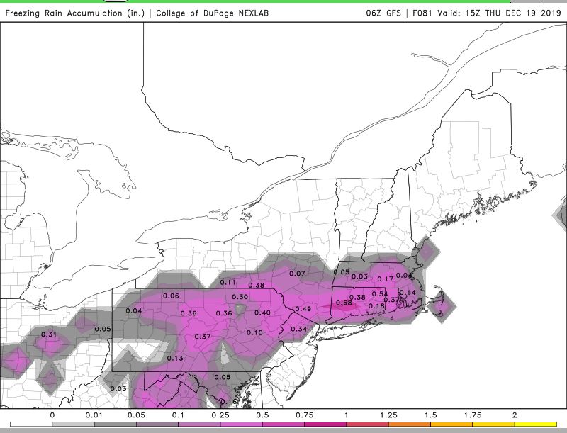
The timing of the ice storm would be between 10-11pm this evening to 10-11am tomorrow morning. Some areas will still see precip falling beyond 11am tomorrow. Please be careful if you live in one of these areas that is in deep purple on the map above.
_________________
_______________________________________________________________________________________________________
CLICK HERE to view NJ Strong Snowstorm Classifications

Frank_Wx- Godzilla Seeker

- Posts : 21305
Reputation : 328
Join date : 2013-01-05
Age : 32
Location : Jersey City, NJ -

Re: Dec 16-17 Snow/Ice potential storm
![]() by Frank_Wx Mon Dec 16, 2019 8:28 am
by Frank_Wx Mon Dec 16, 2019 8:28 am
heehaw453 wrote:See CAD signature at the lower levels now. This is 925mb temps. A warm nose is already coming into Pittsburgh. This is a storm which is further south, otherwise the warm nose would be well into PA. How far south it stays determines the baroclinic zone. Interesting stuff.
Nice post, and yes very interesting, however the low pressure has yet to develop over the TN valley. Once it does, with the help of the High Pressure (SE Ridge) off the coast, temps will gradually warm up the coast.
_________________
_______________________________________________________________________________________________________
CLICK HERE to view NJ Strong Snowstorm Classifications
Frank_Wx- Godzilla Seeker
- Posts : 21305
Reputation : 328
Join date : 2013-01-05
Age : 32
Location : Jersey City, NJ -
Re: Dec 16-17 Snow/Ice potential storm
![]() by sroc4 Mon Dec 16, 2019 8:46 am
by sroc4 Mon Dec 16, 2019 8:46 am
Frank_Wx wrote:heehaw453 wrote:See CAD signature at the lower levels now. This is 925mb temps. A warm nose is already coming into Pittsburgh. This is a storm which is further south, otherwise the warm nose would be well into PA. How far south it stays determines the baroclinic zone. Interesting stuff.
Nice post, and yes very interesting, however the low pressure has yet to develop over the TN valley. Once it does, with the help of the High Pressure (SE Ridge) off the coast, temps will gradually warm up the coast.
Will have to see how the surface temps behave when precip makes it into the area though. While there are several locations just above freezing check out dew points region wide. In the high teens to low to mid twenties. Even with a warm mid level one would think if the dew points remain below freezing the surface temps will likely drop a few degrees initially before giving way to the warm air pushing back.
_________________
"In weather and in life, there's no winning and losing; there's only winning and learning."
WINTER 2012/2013 TOTALS 43.65"WINTER 2017/2018 TOTALS 62.85" WINTER 2022/2023 TOTALS 4.9"
WINTER 2013/2014 TOTALS 64.85"WINTER 2018/2019 TOTALS 14.25" WINTER 2023/2024 TOTALS 13.1"
WINTER 2014/2015 TOTALS 71.20"WINTER 2019/2020 TOTALS 6.35"
WINTER 2015/2016 TOTALS 35.00"WINTER 2020/2021 TOTALS 37.75"
WINTER 2016/2017 TOTALS 42.25"WINTER 2021/2022 TOTALS 31.65"

sroc4- Admin
- Posts : 8354
Reputation : 302
Join date : 2013-01-07
Location : Wading River, LI
Re: Dec 16-17 Snow/Ice potential storm
![]() by Frank_Wx Mon Dec 16, 2019 8:56 am
by Frank_Wx Mon Dec 16, 2019 8:56 am
.thumb.png.7de025efe89c9e155f893aa42e141d05.png)
_________________
_______________________________________________________________________________________________________
CLICK HERE to view NJ Strong Snowstorm Classifications
Frank_Wx- Godzilla Seeker
- Posts : 21305
Reputation : 328
Join date : 2013-01-05
Age : 32
Location : Jersey City, NJ -
Re: Dec 16-17 Snow/Ice potential storm
![]() by weatherwatchermom Mon Dec 16, 2019 9:16 am
by weatherwatchermom Mon Dec 16, 2019 9:16 am
Frank_Wx wrote:12z NAM trended a bit to the GFS with showing now little snowfall for NYC Metro.
Thanks Frank for the updates...I think that for us here below the Driscoll Bridge..we should not have much to worry about with this one... current temperature 35
Last edited by weatherwatchermom on Mon Dec 16, 2019 9:52 am; edited 1 time in total

weatherwatchermom- Senior Enthusiast
- Posts : 3793
Reputation : 78
Join date : 2014-11-25
Location : Hazlet Township, NJ
Re: Dec 16-17 Snow/Ice potential storm
![]() by heehaw453 Mon Dec 16, 2019 9:20 am
by heehaw453 Mon Dec 16, 2019 9:20 am
Even though storm hasn't formed I feel the position of these 925's is telling me that cold air will hang tough due to more southerly trajectory of developing storm. Seen this setup before. We'll see.

This is an ice signal for EPA, NNJ and LHV.

heehaw453- Advanced Forecaster
- Posts : 3906
Reputation : 86
Join date : 2014-01-20
Location : Bedminster Township, PA Elevation 600' ASL
Re: Dec 16-17 Snow/Ice potential storm
![]() by jmanley32 Mon Dec 16, 2019 10:18 am
by jmanley32 Mon Dec 16, 2019 10:18 am
jmanley32- Senior Enthusiast
- Posts : 20535
Reputation : 108
Join date : 2013-12-12
Age : 43
Location : Yonkers, NY
Re: Dec 16-17 Snow/Ice potential storm
![]() by hyde345 Mon Dec 16, 2019 10:45 am
by hyde345 Mon Dec 16, 2019 10:45 am

hyde345- Pro Enthusiast
- Posts : 1082
Reputation : 48
Join date : 2013-01-08
Location : Hyde Park, NY
Re: Dec 16-17 Snow/Ice potential storm
![]() by sroc4 Mon Dec 16, 2019 10:54 am
by sroc4 Mon Dec 16, 2019 10:54 am
_________________
"In weather and in life, there's no winning and losing; there's only winning and learning."
WINTER 2012/2013 TOTALS 43.65"WINTER 2017/2018 TOTALS 62.85" WINTER 2022/2023 TOTALS 4.9"
WINTER 2013/2014 TOTALS 64.85"WINTER 2018/2019 TOTALS 14.25" WINTER 2023/2024 TOTALS 13.1"
WINTER 2014/2015 TOTALS 71.20"WINTER 2019/2020 TOTALS 6.35"
WINTER 2015/2016 TOTALS 35.00"WINTER 2020/2021 TOTALS 37.75"
WINTER 2016/2017 TOTALS 42.25"WINTER 2021/2022 TOTALS 31.65"
sroc4- Admin
- Posts : 8354
Reputation : 302
Join date : 2013-01-07
Location : Wading River, LI
Re: Dec 16-17 Snow/Ice potential storm
![]() by Frank_Wx Mon Dec 16, 2019 11:05 am
by Frank_Wx Mon Dec 16, 2019 11:05 am
weatherwatchermom wrote:Frank_Wx wrote:12z NAM trended a bit to the GFS with showing now little snowfall for NYC Metro.
Thanks Frank for the updates...I think that for us here below the Driscoll Bridge..we should not have much to worry about with this one... current temperature 35
You're welcome! Yea the shore is spared for this one.
jmanley32 wrote:What does nam show in terms of icing? I still think it'll come closer to the coast than modeled along with snow. Just going by what you guts are saying about the cold at 850 vs surface.
The 12z NAM cut back on snow an ice accumulations for NYC Metro.
hyde345 wrote:I'm 75 miles north of NYC and the forecast is for snow tonight changing to sleet and a little ZR around daybreak and then changing back to snow tomorrow afternoon before ending. Total snow 2-5 inches with sleet and .10 of ice. This is going to be a very bad ice storm for a lot of people although I think 1 inch of ice is a little overdone. That would be devastating with power outages and then some very cold air coming into region.
Yes, I am not sure how far north the ice risk extends but 0.10" for your area sounds reasonable. Be careful!
_________________
_______________________________________________________________________________________________________
CLICK HERE to view NJ Strong Snowstorm Classifications
Frank_Wx- Godzilla Seeker
- Posts : 21305
Reputation : 328
Join date : 2013-01-05
Age : 32
Location : Jersey City, NJ -
Re: Dec 16-17 Snow/Ice potential storm
![]() by jmanley32 Mon Dec 16, 2019 11:30 am
by jmanley32 Mon Dec 16, 2019 11:30 am
jmanley32- Senior Enthusiast
- Posts : 20535
Reputation : 108
Join date : 2013-12-12
Age : 43
Location : Yonkers, NY
Re: Dec 16-17 Snow/Ice potential storm
![]() by Frank_Wx Mon Dec 16, 2019 11:34 am
by Frank_Wx Mon Dec 16, 2019 11:34 am
jmanley32 wrote:Frank what about yonkers and then 20 miles north white plains? In terms of ice and snow? So you guts aren't buying the ice amounts? Or did they go down at 12z I don't have time to look.
I posted my thoughts earlier this morning in this thread. Give it a read and if you still have questions let me know!
_________________
_______________________________________________________________________________________________________
CLICK HERE to view NJ Strong Snowstorm Classifications
Frank_Wx- Godzilla Seeker
- Posts : 21305
Reputation : 328
Join date : 2013-01-05
Age : 32
Location : Jersey City, NJ -
Re: Dec 16-17 Snow/Ice potential storm
![]() by Frank_Wx Mon Dec 16, 2019 11:35 am
by Frank_Wx Mon Dec 16, 2019 11:35 am

_________________
_______________________________________________________________________________________________________
CLICK HERE to view NJ Strong Snowstorm Classifications
Frank_Wx- Godzilla Seeker
- Posts : 21305
Reputation : 328
Join date : 2013-01-05
Age : 32
Location : Jersey City, NJ -
Re: Dec 16-17 Snow/Ice potential storm
![]() by jmanley32 Mon Dec 16, 2019 11:44 am
by jmanley32 Mon Dec 16, 2019 11:44 am
sorry Frank missed ur earlier post. I think it's go be a fine line wether I see more than city. Mog that's horrid most over half a inch plus!! If that comes true nj and most of Westchester to lhv are go be without power.Frank_Wx wrote:The CMC, or Canadian model, is persistent and agrees with the short range models like the NAM that the ice threat will extend toward the coast. Again, I am not a believer in this scenario but would like to digest additional model runs later today and see if this holds any merit
jmanley32- Senior Enthusiast
- Posts : 20535
Reputation : 108
Join date : 2013-12-12
Age : 43
Location : Yonkers, NY
Re: Dec 16-17 Snow/Ice potential storm
![]() by heehaw453 Mon Dec 16, 2019 12:30 pm
by heehaw453 Mon Dec 16, 2019 12:30 pm
Wet bulb temps still below freezing for most.
What the HRDPS is showing would be like a once in 20 year ice storm. 3/4" - 1" range. I think more like .25" - .5" is possible 40 miles NW of 95.


heehaw453- Advanced Forecaster
- Posts : 3906
Reputation : 86
Join date : 2014-01-20
Location : Bedminster Township, PA Elevation 600' ASL
Page 4 of 11 • 1, 2, 3, 4, 5 ... 9, 10, 11 ![]()
|
|
|