
 Search
Dec 16-17 Snow/Ice potential storm
Page 5 of 11 •  1, 2, 3, 4, 5, 6 ... 9, 10, 11
 ![]()
Re: Dec 16-17 Snow/Ice potential storm
![]() by jmanley32 Mon Dec 16, 2019 11:44 am
by jmanley32 Mon Dec 16, 2019 11:44 am
sorry Frank missed ur earlier post. I think it's go be a fine line wether I see more than city. Mog that's horrid most over half a inch plus!! If that comes true nj and most of Westchester to lhv are go be without power.Frank_Wx wrote:The CMC, or Canadian model, is persistent and agrees with the short range models like the NAM that the ice threat will extend toward the coast. Again, I am not a believer in this scenario but would like to digest additional model runs later today and see if this holds any merit

jmanley32- Senior Enthusiast

- Posts : 20535
Join date : 2013-12-12
Re: Dec 16-17 Snow/Ice potential storm
![]() by heehaw453 Mon Dec 16, 2019 12:30 pm
by heehaw453 Mon Dec 16, 2019 12:30 pm
Wet bulb temps still below freezing for most.
What the HRDPS is showing would be like a once in 20 year ice storm. 3/4" - 1" range. I think more like .25" - .5" is possible 40 miles NW of 95.


heehaw453- Advanced Forecaster

- Posts : 3906
Join date : 2014-01-20
Re: Dec 16-17 Snow/Ice potential storm
![]() by bloc1357 Mon Dec 16, 2019 12:42 pm
by bloc1357 Mon Dec 16, 2019 12:42 pm
bloc1357- Pro Enthusiast

- Posts : 344
Reputation : 10
Join date : 2013-03-05
Age : 47
Location : West Babylon, NY - 11704
Re: Dec 16-17 Snow/Ice potential storm
![]() by amugs Mon Dec 16, 2019 12:45 pm
by amugs Mon Dec 16, 2019 12:45 pm
I see the meso's forming a LP off the SNJ coast and I listen to NSFXwx a very good pro met on twitch. He explained why the LP will op and strengthen - the EURO actually sees this but weaker than the mesos and the flow is CC - it doesn't need to be strong since teh cold air source over head is just that ..cold.
I am not rooting for this scenario just pointing this out - if the mesos are right then this storm becomes even more serious. Western BC through Sussex is in trouble .
From Mike Mostwill
The latest HREF depicting a potential mess overnight tonight into Tuesday early afternoon. The low level cold air is dense in nature & is illustrated well here, despite ML warmth. It takes more time to scour out, slower than the mid layers of the atmosphere.
https://twitter.com/MikeMostwill/status/1206611268418842624?s=20
_________________
Mugs
AKA:King: Snow Weenie
Self Proclaimed
WINTER 2014-15 : 55.12" +.02 for 6 coatings (avg. 35")
WINTER 2015-16 Total - 29.8" (Avg 35")
WINTER 2016-17 : 39.5" so far

amugs- Advanced Forecaster - Mod

- Posts : 15095
Reputation : 213
Join date : 2013-01-07
Age : 54
Location : Hillsdale,NJ
Re: Dec 16-17 Snow/Ice potential storm
![]() by amugs Mon Dec 16, 2019 12:48 pm
by amugs Mon Dec 16, 2019 12:48 pm
_________________
Mugs
AKA:King: Snow Weenie
Self Proclaimed
WINTER 2014-15 : 55.12" +.02 for 6 coatings (avg. 35")
WINTER 2015-16 Total - 29.8" (Avg 35")
WINTER 2016-17 : 39.5" so far
amugs- Advanced Forecaster - Mod
- Posts : 15095
Reputation : 213
Join date : 2013-01-07
Age : 54
Location : Hillsdale,NJ
Re: Dec 16-17 Snow/Ice potential storm
![]() by algae888 Mon Dec 16, 2019 12:59 pm
by algae888 Mon Dec 16, 2019 12:59 pm

algae888- Advanced Forecaster
- Posts : 5311
Reputation : 46
Join date : 2013-02-05
Age : 62
Location : mt. vernon, new york
Re: Dec 16-17 Snow/Ice potential storm
![]() by algae888 Mon Dec 16, 2019 1:15 pm
by algae888 Mon Dec 16, 2019 1:15 pm
algae888- Advanced Forecaster
- Posts : 5311
Reputation : 46
Join date : 2013-02-05
Age : 62
Location : mt. vernon, new york
Re: Dec 16-17 Snow/Ice potential storm
![]() by heehaw453 Mon Dec 16, 2019 1:33 pm
by heehaw453 Mon Dec 16, 2019 1:33 pm

heehaw453- Advanced Forecaster
- Posts : 3906
Reputation : 86
Join date : 2014-01-20
Location : Bedminster Township, PA Elevation 600' ASL
Re: Dec 16-17 Snow/Ice potential storm
![]() by amugs Mon Dec 16, 2019 1:53 pm
by amugs Mon Dec 16, 2019 1:53 pm
The ZR is sleet in the model configuration/algorithm which is ice but not nearly as damaging as ZR (ZR=Freezing Rain). That is good news if true.
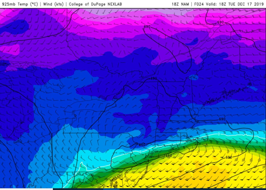
HH that 925 map is telling - the storm isnt like you said gonna bully its way through this LLC since its not a coastal - SWFE event LP are weak in nature and my 30 years of following these the CAD usually wins out with a weak LP.
_________________
Mugs
AKA:King: Snow Weenie
Self Proclaimed
WINTER 2014-15 : 55.12" +.02 for 6 coatings (avg. 35")
WINTER 2015-16 Total - 29.8" (Avg 35")
WINTER 2016-17 : 39.5" so far
amugs- Advanced Forecaster - Mod
- Posts : 15095
Reputation : 213
Join date : 2013-01-07
Age : 54
Location : Hillsdale,NJ
Re: Dec 16-17 Snow/Ice potential storm
![]() by hyde345 Mon Dec 16, 2019 1:55 pm
by hyde345 Mon Dec 16, 2019 1:55 pm

hyde345- Pro Enthusiast
- Posts : 1082
Reputation : 48
Join date : 2013-01-08
Location : Hyde Park, NY
Re: Dec 16-17 Snow/Ice potential storm
![]() by amugs Mon Dec 16, 2019 2:00 pm
by amugs Mon Dec 16, 2019 2:00 pm

_________________
Mugs
AKA:King: Snow Weenie
Self Proclaimed
WINTER 2014-15 : 55.12" +.02 for 6 coatings (avg. 35")
WINTER 2015-16 Total - 29.8" (Avg 35")
WINTER 2016-17 : 39.5" so far
amugs- Advanced Forecaster - Mod
- Posts : 15095
Reputation : 213
Join date : 2013-01-07
Age : 54
Location : Hillsdale,NJ
Re: Dec 16-17 Snow/Ice potential storm
![]() by sroc4 Mon Dec 16, 2019 2:01 pm
by sroc4 Mon Dec 16, 2019 2:01 pm
amugs wrote:@Al and Hee Haw great posts.
The ZR is sleet in the model configuration/algorithm which is ice but not nearly as damaging as ZR (ZR=Freezing Rain). That is good news if true.
HH that 925 map is telling - the storm isnt like you said gonna bully its way through this LLC since its not a coastal - SWFE event LP are weak in nature and my 30 years of following these the CAD usually wins out with a weak LP.
And while I certainly wouldn't lock onto the absolute totals on this map, the hrrr has consistently run after run (it runs every hour) trended colder and colder throughout the day

_________________
"In weather and in life, there's no winning and losing; there's only winning and learning."
WINTER 2012/2013 TOTALS 43.65"WINTER 2017/2018 TOTALS 62.85" WINTER 2022/2023 TOTALS 4.9"
WINTER 2013/2014 TOTALS 64.85"WINTER 2018/2019 TOTALS 14.25" WINTER 2023/2024 TOTALS 13.1"
WINTER 2014/2015 TOTALS 71.20"WINTER 2019/2020 TOTALS 6.35"
WINTER 2015/2016 TOTALS 35.00"WINTER 2020/2021 TOTALS 37.75"
WINTER 2016/2017 TOTALS 42.25"WINTER 2021/2022 TOTALS 31.65"

sroc4- Admin

- Posts : 8354
Reputation : 302
Join date : 2013-01-07
Location : Wading River, LI
Re: Dec 16-17 Snow/Ice potential storm
![]() by amugs Mon Dec 16, 2019 2:01 pm
by amugs Mon Dec 16, 2019 2:01 pm

0Z run

_________________
Mugs
AKA:King: Snow Weenie
Self Proclaimed
WINTER 2014-15 : 55.12" +.02 for 6 coatings (avg. 35")
WINTER 2015-16 Total - 29.8" (Avg 35")
WINTER 2016-17 : 39.5" so far
amugs- Advanced Forecaster - Mod
- Posts : 15095
Reputation : 213
Join date : 2013-01-07
Age : 54
Location : Hillsdale,NJ
Re: Dec 16-17 Snow/Ice potential storm
![]() by Frank_Wx Mon Dec 16, 2019 2:11 pm
by Frank_Wx Mon Dec 16, 2019 2:11 pm
amugs wrote:
Very close to the GFS ice map. Models are pretty locked in. Man if these ice projections are correct it's going to be downright horrific for some places.
@Scott - the HRRR could be onto something with a quick burst of snow that happens around Midnight for NYC Metro before changing to rain. But the changeover to mix/rain will be fairly quick.
_________________
_______________________________________________________________________________________________________
CLICK HERE to view NJ Strong Snowstorm Classifications

Frank_Wx- Godzilla Seeker
- Posts : 21305
Reputation : 328
Join date : 2013-01-05
Age : 32
Location : Jersey City, NJ -

Re: Dec 16-17 Snow/Ice potential storm
![]() by Frank_Wx Mon Dec 16, 2019 2:13 pm
by Frank_Wx Mon Dec 16, 2019 2:13 pm

_________________
_______________________________________________________________________________________________________
CLICK HERE to view NJ Strong Snowstorm Classifications
Frank_Wx- Godzilla Seeker
- Posts : 21305
Reputation : 328
Join date : 2013-01-05
Age : 32
Location : Jersey City, NJ -
Re: Dec 16-17 Snow/Ice potential storm
![]() by algae888 Mon Dec 16, 2019 2:31 pm
by algae888 Mon Dec 16, 2019 2:31 pm
algae888- Advanced Forecaster
- Posts : 5311
Reputation : 46
Join date : 2013-02-05
Age : 62
Location : mt. vernon, new york
Re: Dec 16-17 Snow/Ice potential storm
![]() by heehaw453 Mon Dec 16, 2019 2:38 pm
by heehaw453 Mon Dec 16, 2019 2:38 pm
Frank_Wx wrote:amugs wrote:
Very close to the GFS ice map. Models are pretty locked in. Man if these ice projections are correct it's going to be downright horrific for some places.
@Scott - the HRRR could be onto something with a quick burst of snow that happens around Midnight for NYC Metro before changing to rain. But the changeover to mix/rain will be fairly quick.
That has my area at .25". Meso's like NAM and HRDPS are 3x that for EPA. Order of magnitude difference in effect. I'm hoping globals handle the ice better, but skeptical that it'll be more.
heehaw453- Advanced Forecaster
- Posts : 3906
Reputation : 86
Join date : 2014-01-20
Location : Bedminster Township, PA Elevation 600' ASL
Re: Dec 16-17 Snow/Ice potential storm
![]() by jmanley32 Mon Dec 16, 2019 3:01 pm
by jmanley32 Mon Dec 16, 2019 3:01 pm
pushed north a bit I was in the ice on earlier models. This is all a nowcast I think. Will be interesting for sure.heehaw453 wrote:Frank_Wx wrote:amugs wrote:
Very close to the GFS ice map. Models are pretty locked in. Man if these ice projections are correct it's going to be downright horrific for some places.
@Scott - the HRRR could be onto something with a quick burst of snow that happens around Midnight for NYC Metro before changing to rain. But the changeover to mix/rain will be fairly quick.
That has my area at .25". Meso's like NAM and HRDPS are 3x that for EPA. Order of magnitude difference in effect. I'm hoping globals handle the ice better, but skeptical that it'll be more.

jmanley32- Senior Enthusiast
- Posts : 20535
Reputation : 108
Join date : 2013-12-12
Age : 43
Location : Yonkers, NY
Re: Dec 16-17 Snow/Ice potential storm
![]() by Frank_Wx Mon Dec 16, 2019 3:07 pm
by Frank_Wx Mon Dec 16, 2019 3:07 pm


_________________
_______________________________________________________________________________________________________
CLICK HERE to view NJ Strong Snowstorm Classifications
Frank_Wx- Godzilla Seeker
- Posts : 21305
Reputation : 328
Join date : 2013-01-05
Age : 32
Location : Jersey City, NJ -
Re: Dec 16-17 Snow/Ice potential storm
![]() by bobjohnsonforthehall Mon Dec 16, 2019 3:11 pm
by bobjohnsonforthehall Mon Dec 16, 2019 3:11 pm
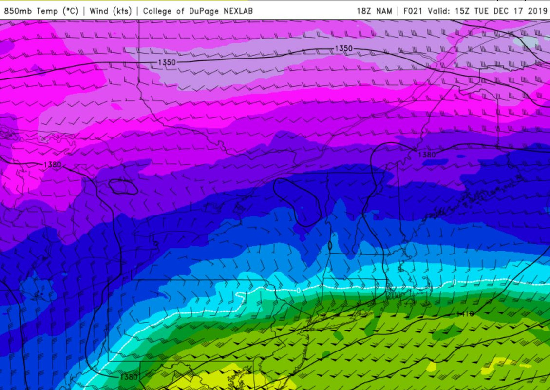
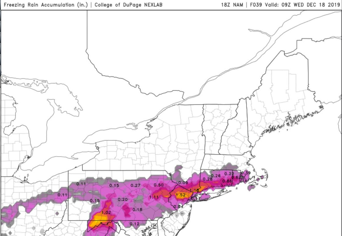
Frank_Wx wrote:18z NAM ice and snow maps
That ice had better be sleet and not all freezing rain. The half inch by me would be bad enough, but an incha nd a quarter plus? That would be historic.

bobjohnsonforthehall- Posts : 311
Reputation : 19
Join date : 2016-10-02
Location : Flemington NJ
Re: Dec 16-17 Snow/Ice potential storm
![]() by Frank_Wx Mon Dec 16, 2019 3:16 pm
by Frank_Wx Mon Dec 16, 2019 3:16 pm
Here is the warmest frame of 925mb temps on the 18z NAM
Total freezing rain accum:
_________________
_______________________________________________________________________________________________________
CLICK HERE to view NJ Strong Snowstorm Classifications
Frank_Wx- Godzilla Seeker
- Posts : 21305
Reputation : 328
Join date : 2013-01-05
Age : 32
Location : Jersey City, NJ -
Re: Dec 16-17 Snow/Ice potential storm
![]() by heehaw453 Mon Dec 16, 2019 3:18 pm
by heehaw453 Mon Dec 16, 2019 3:18 pm
Frank_Wx wrote:18z NAM ice and snow maps
The ice trend is not good. The NAM brought significant icing more s/e. I'd be surprised in NWS doesn't sound the ice storm warning with afternoon package.
heehaw453- Advanced Forecaster
- Posts : 3906
Reputation : 86
Join date : 2014-01-20
Location : Bedminster Township, PA Elevation 600' ASL
Re: Dec 16-17 Snow/Ice potential storm
![]() by Frank_Wx Mon Dec 16, 2019 3:18 pm
by Frank_Wx Mon Dec 16, 2019 3:18 pm
If the white line is N&W of you on both maps you are raining. If 925mb is cold but 850mb is warm there is either sleet or freezing rain falling. One has to look and really understand soundings to know for sure the precip type
_________________
_______________________________________________________________________________________________________
CLICK HERE to view NJ Strong Snowstorm Classifications
Frank_Wx- Godzilla Seeker
- Posts : 21305
Reputation : 328
Join date : 2013-01-05
Age : 32
Location : Jersey City, NJ -
Re: Dec 16-17 Snow/Ice potential storm
![]() by Frank_Wx Mon Dec 16, 2019 3:24 pm
by Frank_Wx Mon Dec 16, 2019 3:24 pm

_________________
_______________________________________________________________________________________________________
CLICK HERE to view NJ Strong Snowstorm Classifications
Frank_Wx- Godzilla Seeker
- Posts : 21305
Reputation : 328
Join date : 2013-01-05
Age : 32
Location : Jersey City, NJ -
Re: Dec 16-17 Snow/Ice potential storm
![]() by heehaw453 Mon Dec 16, 2019 3:25 pm
by heehaw453 Mon Dec 16, 2019 3:25 pm

heehaw453- Advanced Forecaster
- Posts : 3906
Reputation : 86
Join date : 2014-01-20
Location : Bedminster Township, PA Elevation 600' ASL
Re: Dec 16-17 Snow/Ice potential storm
![]() by CPcantmeasuresnow Mon Dec 16, 2019 3:26 pm
by CPcantmeasuresnow Mon Dec 16, 2019 3:26 pm
heehaw453 wrote:Frank_Wx wrote:18z NAM ice and snow maps
The ice trend is not good. The NAM brought significant icing more s/e. I'd be surprised in NWS doesn't sound the ice storm warning with afternoon package.
I's borderline, remember ice storm warning criteria differs in NYS and New England vs CNJ and Pennsylvania south. It's 1/2 inch of ice in all of NY State, NNJ and all of New England, anywhere south of there it's a 1/4 inch.

CPcantmeasuresnow- Wx Statistician Guru

- Posts : 7274
Reputation : 230
Join date : 2013-01-07
Age : 103
Location : Eastern Orange County, NY
Re: Dec 16-17 Snow/Ice potential storm
![]() by heehaw453 Mon Dec 16, 2019 3:30 pm
by heehaw453 Mon Dec 16, 2019 3:30 pm
CPcantmeasuresnow wrote:heehaw453 wrote:Frank_Wx wrote:18z NAM ice and snow maps
The ice trend is not good. The NAM brought significant icing more s/e. I'd be surprised in NWS doesn't sound the ice storm warning with afternoon package.
I's borderline, remember ice storm warning criteria differs in NYS and New England vs CNJ and Pennsylvania south. It's 1/2 inch of ice in all of NY State, NNJ and all of New England, anywhere south of there it's a 1/4 inch.
I think Sussex, Passaic and Morris County in NJ you really got to pull that trigger now. Sounding suggest heavy freezing rain 30-31 degree surface temperature. This would easily exceed 1/2".
heehaw453- Advanced Forecaster
- Posts : 3906
Reputation : 86
Join date : 2014-01-20
Location : Bedminster Township, PA Elevation 600' ASL
Page 5 of 11 • 1, 2, 3, 4, 5, 6 ... 9, 10, 11 ![]()
|
|
|