Tropical Storm Isaias
+31
Bkdude
sabamfa
SkiSeadooJoe
obsessedwithweather
essexcountypete
Grselig
New Yorker 234
Radz
docstox12
larryrock72
Vinnydula
dkodgis
rb924119
SoulSingMG
aiannone
sroc4
brownie
GreyBeard
Zhukov1945
HectorO
dsvinos
Sanchize06
amugs
weatherwatchermom
Dunnzoo
billg315
jmanley32
mwilli
frank 638
Sparky Sparticles
Frank_Wx
35 posters
Page 1 of 13
Page 1 of 13 • 1, 2, 3 ... 11, 12, 13 
 Tropical Storm Isaias
Tis' the season.
After an uneventful winter I have a feeling we're going to be in for an active hurricane season. The first storm to hit our area will be TS Isaias. Whether he re-strengthens to a Cat 1 hurricane or not is not so important to me, as by the time he reaches our latitude, he is likely to be either a Tropical Storm or some type of extratropical system. His interaction with the 500mb trough and the upper level jet will act as 'fuel' to keep him as a fairly significant and high impact storm.

That is one heck of a 250mb jet streak directly above Isaias. As he moves north and begins to interact with its upper level pattern, there will be moments during the storm when rainfall rates will be 2-3" per hour. The location of this upper level jet streak, the timing of the capture with the 500mb trough, and the location of the 500mb 'Bermuda' High Pressure, will act as the main factors that dictate the path of the storm. As mentioned, I believe the center tracks right over Philadelphia and into central/west-central NJ. That means, for the majority of the people on this weather board, the concern will be high winds more than it will be flooding rains.
Rain:
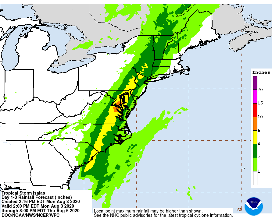
Eastern/Central Long Island will see less than 1"
NYC/Western Long Island, Jersey Shore will see about 1" to 1.50"
Eastern NJ (just inland from shore) including east-central and NE NJ, will see 1.50" to 2.50"
Western NJ including north-central and NW NJ, will see 2.50" to 3.50"
There will be parts of extreme NW NJ, specifically EPA and SW NY, that approach 6" with 4" amounts being very common
Wind:
EURO

GFS
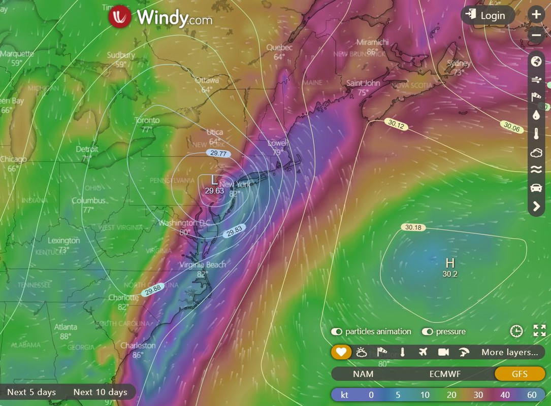
Both models are signaling for extremely high and dangerous winds for the areas not forecasted to see 2"+ rainfall. I think wind gusts in excess of 80 mph are a stretch. Despite the favorable set-up, I have a very hard time believing the EURO/UKMET. Instead, I am thinking gusts will exceed 60 mph and in some cases 70 mph for Jersey Shore and central/eastern LI. For everyone else, I definitely think 40-50 mph wind gusts are possible. Regardless, those wind speeds will produce scattered power outages and damage. Please take the wind threat seriously despite my pessimism with whether or not it actually comes to fruition.
Surge:

A 1 to 3 foot storm surge seems a little underdone given the latest models. Perhaps 2 to 4 feet is more realistic in my opinion. If you live along the coast, and a surge of 4 feet causes flooding, NOW is the time to prepare. Only you know what type of impact coastal flooding will look like for your area depending on the surge forecast. I can't forecast that for you!!!
Timing:
Rain will start after midnight. I have a feeling most people won't see rain start until 3-4am. Rain will become steady by 8-9am on Tuesday. The worst of the rain and wind will be 2pm-6pm. By 7-8pm, it's possible the storm will be done. It is a VERY fast moving system.
Stay safe everyone!!
After an uneventful winter I have a feeling we're going to be in for an active hurricane season. The first storm to hit our area will be TS Isaias. Whether he re-strengthens to a Cat 1 hurricane or not is not so important to me, as by the time he reaches our latitude, he is likely to be either a Tropical Storm or some type of extratropical system. His interaction with the 500mb trough and the upper level jet will act as 'fuel' to keep him as a fairly significant and high impact storm.

That is one heck of a 250mb jet streak directly above Isaias. As he moves north and begins to interact with its upper level pattern, there will be moments during the storm when rainfall rates will be 2-3" per hour. The location of this upper level jet streak, the timing of the capture with the 500mb trough, and the location of the 500mb 'Bermuda' High Pressure, will act as the main factors that dictate the path of the storm. As mentioned, I believe the center tracks right over Philadelphia and into central/west-central NJ. That means, for the majority of the people on this weather board, the concern will be high winds more than it will be flooding rains.
Rain:
Eastern/Central Long Island will see less than 1"
NYC/Western Long Island, Jersey Shore will see about 1" to 1.50"
Eastern NJ (just inland from shore) including east-central and NE NJ, will see 1.50" to 2.50"
Western NJ including north-central and NW NJ, will see 2.50" to 3.50"
There will be parts of extreme NW NJ, specifically EPA and SW NY, that approach 6" with 4" amounts being very common
Wind:
EURO

GFS

Both models are signaling for extremely high and dangerous winds for the areas not forecasted to see 2"+ rainfall. I think wind gusts in excess of 80 mph are a stretch. Despite the favorable set-up, I have a very hard time believing the EURO/UKMET. Instead, I am thinking gusts will exceed 60 mph and in some cases 70 mph for Jersey Shore and central/eastern LI. For everyone else, I definitely think 40-50 mph wind gusts are possible. Regardless, those wind speeds will produce scattered power outages and damage. Please take the wind threat seriously despite my pessimism with whether or not it actually comes to fruition.
Surge:

A 1 to 3 foot storm surge seems a little underdone given the latest models. Perhaps 2 to 4 feet is more realistic in my opinion. If you live along the coast, and a surge of 4 feet causes flooding, NOW is the time to prepare. Only you know what type of impact coastal flooding will look like for your area depending on the surge forecast. I can't forecast that for you!!!
Timing:
Rain will start after midnight. I have a feeling most people won't see rain start until 3-4am. Rain will become steady by 8-9am on Tuesday. The worst of the rain and wind will be 2pm-6pm. By 7-8pm, it's possible the storm will be done. It is a VERY fast moving system.
Stay safe everyone!!
_________________
_______________________________________________________________________________________________________
CLICK HERE to view NJ Strong Snowstorm Classifications
 Re: Tropical Storm Isaias
[quote="Frank_Wx"]
Thanks for the write-up and explanations.
WeatherUnderground is saying rain starts with thunderstorms around 7pm tonight.
Of course - this is when I have to be out to a doctor's appointment.
Well, this is good news, no matter how good or bad the storm is. My son works nights and usually leaves at 8:30pm. At least he'll know early enough if 1) light rail is running and 2) if the store is flooded or lost power and night shift is cancelled long before he leave the house and walks to the train station. His job is within walking distance of Hoboken in JC, and that whole area was pretty devastated during Sandy.
Thanks for the write-up and explanations.
Timing:
Rain will start after midnight. I have a feeling most people won't see rain start until 3-4am.
WeatherUnderground is saying rain starts with thunderstorms around 7pm tonight.
Rain will become steady by 8-9am on Tuesday.
Of course - this is when I have to be out to a doctor's appointment.
By 7-8pm, it's possible the storm will be done. It is a VERY fast moving system.
Well, this is good news, no matter how good or bad the storm is. My son works nights and usually leaves at 8:30pm. At least he'll know early enough if 1) light rail is running and 2) if the store is flooded or lost power and night shift is cancelled long before he leave the house and walks to the train station. His job is within walking distance of Hoboken in JC, and that whole area was pretty devastated during Sandy.

Sparky Sparticles- Posts : 124
Reputation : 1
Join date : 2014-02-11
Age : 70
Location : Bayonne, NJ
 Re: Tropical Storm Isaias
I said rain will start after midnight. I should note there are training t-storms already working themselves into the area. Technically, these are part of the greater storm that is Isaias. Therefore, I am modifying the start time from midnight to possibly 8pm this evening.
https://radar.weather.gov/lite/N0Z/LTX_loop.gif
https://radar.weather.gov/lite/N0Z/LTX_loop.gif
_________________
_______________________________________________________________________________________________________
CLICK HERE to view NJ Strong Snowstorm Classifications
 Re: Tropical Storm Isaias
https://s.w-x.co/staticmaps/wu/wu/satir1200_cur/usase/animate.png
_________________
_______________________________________________________________________________________________________
CLICK HERE to view NJ Strong Snowstorm Classifications
 Re: Tropical Storm Isaias
Hey frank I hope everything’s going well anyway thank you for the Write up and map you posted .I’m just worried about the wind for tomorrow especially where I am And north and east of us. Do you think we have to worry about tornadoes
frank 638- Senior Enthusiast

- Posts : 2843
Reputation : 37
Join date : 2016-01-01
Age : 40
Location : bronx ny
 Re: Tropical Storm Isaias
Great write-up Frank,I won't classify this as a Mothrazilla type storm,I'm looking more in to these waves out of Africa now,and were not even at peak yet.
mwilli- Posts : 132
Reputation : 3
Join date : 2019-02-11
 Re: Tropical Storm Isaias
Great writeup Frank and my only disagreement with you is to up the wind gusts for most to 60 plus, def not 80mph though you never know on LI. That being said NHC currently says most are sustained in 40-50mph range with gusts to 70mph (purely by what the NHC is saying, not trying to debunk your thoughts), do you think they are overplaying it or is that possible? I agree totally with the rainfall, and then of course theres the chance of severe weather that you did not mention as with most TS a potential exists for tornadoes as is shown by SPC. Euro is always too high on gusts we know that, id shave off 10mph or so maybe more further west you go. Track seems pretty much a lock. He looks so odd on sattelite, if I didn't know I would think it was just a storm, such a mess. The NHC doesn't have him going subtropical until after our area but of course thats subject to change. I hope I havent been too much of a pesty poster I just love the tropics and hey, this is an enthusists forum right? Now we watch and see its nearing nowcast time though I dunno if bands start moving in at 8pm, looks way to far south still. Again thanks for creating new thread I think it important we track each seperately. You also said this is the first, Fay was actually the first, but she ended up being nothing to note, this once is much more noteworthy IMO.
Frank when do the winds start up, the Euro map you have is accumulated so i don't know exactly what time the strongest will come, do they start ramping up in the morning and through the afternoon late evening? Especially if over by 8pm?
Frank when do the winds start up, the Euro map you have is accumulated so i don't know exactly what time the strongest will come, do they start ramping up in the morning and through the afternoon late evening? Especially if over by 8pm?
Last edited by jmanley32 on Mon Aug 03, 2020 3:53 pm; edited 1 time in total

jmanley32- Senior Enthusiast

- Posts : 20535
Reputation : 108
Join date : 2013-12-12
Age : 43
Location : Yonkers, NY
 Re: Tropical Storm Isaias
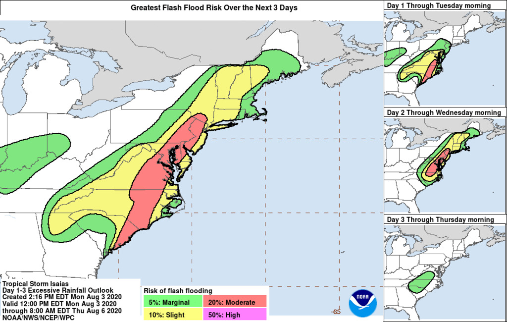
I think any way you cut it, tomorrow is going to be a bad situation. If you’re to the west edge of our region I see serious flooding issues with 4-6” of rain in a 12-hour period; if you’re to the East I see lots of wind damage from persistent 60 mph-plus gusts. The Shore (at least where I go) seems to flood from even minor rain storms a lot now, so even if they only get 1-2”, that combined with a storm surge and a Full Moon (!) means coastal flooding issues. And I think power outages are a threat everywhere. Should be a lovely Tuesday.

billg315- Advanced Forecaster - Mod

- Posts : 4483
Reputation : 185
Join date : 2015-01-24
Age : 50
Location : Flemington, NJ
 Re: Tropical Storm Isaias
I am amateur Jim Cantore I will be going over to th Hudson at some point, yeah might be unsafe but I will guage how bad it is b4 I go. If we truly are seeing damage and gusts 70mph prolly will forego it im not that crazy, i went out in Sandy at the height and was scared shitless. I literally ran back from up the street fighting the wind in pitch darkness as all power had gone out, it was dumb.billg315 wrote:I think any way you cut it, tomorrow is going to be a bad situation. If you’re to the west edge of our region I see serious flooding issues with 4-6” of rain in a 12-hour period; if you’re to the East I see lots of wind damage from persistent 60 mph-plus gusts. The Shore (at least where I go) seems to flood from even minor rain storms a lot now, so even if they only get 1-2”, that combined with a storm surge and a Full Moon (!) means coastal flooding issues. And I think power outages are a threat everywhere. Should be a lovely Tuesday.

jmanley32- Senior Enthusiast

- Posts : 20535
Reputation : 108
Join date : 2013-12-12
Age : 43
Location : Yonkers, NY
Sparky Sparticles likes this post
 Re: Tropical Storm Isaias
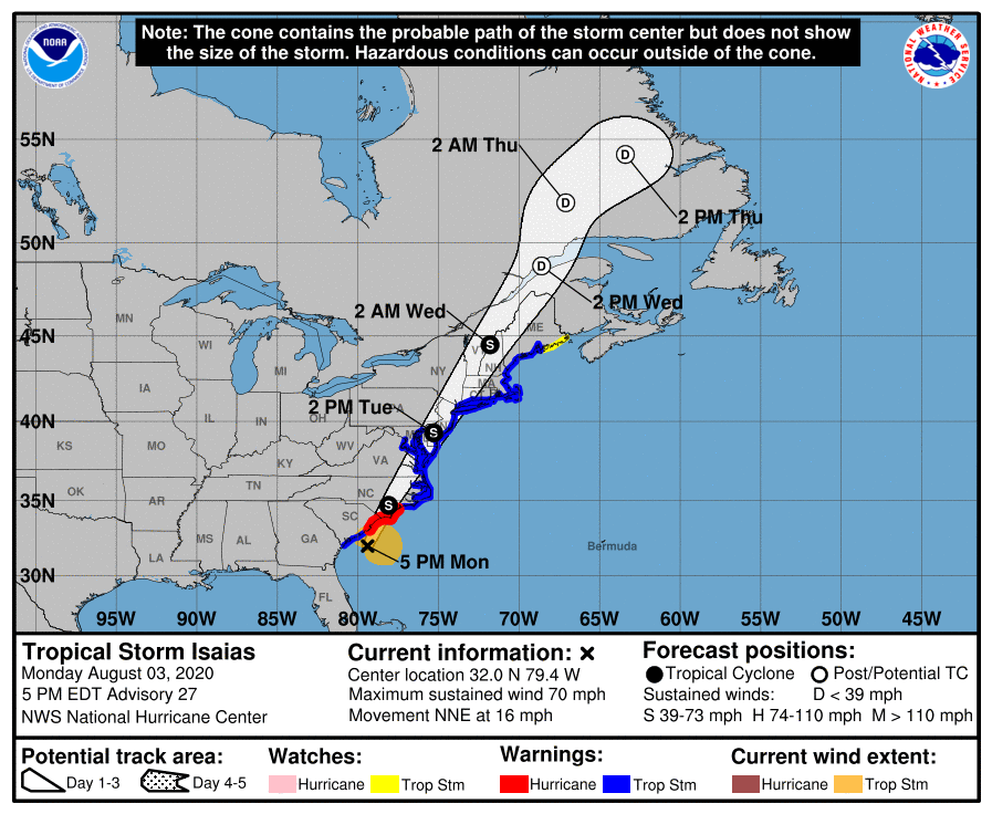
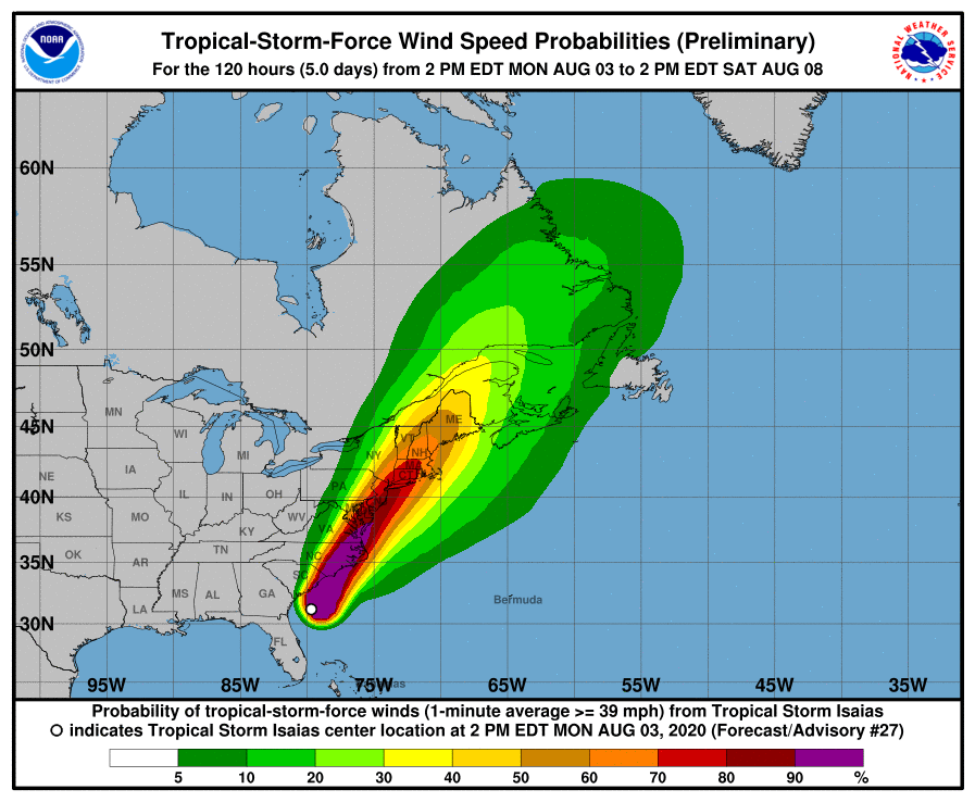
5pm update intensity, we are at the 65mph mark a ick up in intensity from 11am
INIT 03/1500Z 30.7N 80.1W 60 KT 70 MPH
12H 04/0000Z 33.1N 79.2W 65 KT 75 MPH
24H 04/1200Z 37.2N 77.0W 55 KT 65 MPH...INLAND
36H 05/0000Z 42.0N 73.8W 50 KT 60 MPH...INLAND
48H 05/1200Z 46.7N 70.2W 35 KT 40 MPH...INLAND
60H 06/0000Z 50.2N 67.2W 30 KT 35 MPH...POST-TROP/EXTRATROP
72H 06/1200Z 53.5N 64.2W 25 KT 30 MPH...POST-TROP/EXTRATROP
96H 07/1200Z...DISSIPATED


jmanley32- Senior Enthusiast

- Posts : 20535
Reputation : 108
Join date : 2013-12-12
Age : 43
Location : Yonkers, NY
 Re: Tropical Storm Isaias
One thing that concerns me about the heaviest rains being just to our west is I’ve seen so many of these storms end up tracking a little east of projections as they get further north. It wouldn’t take a big jog East from its current track for all of NJ to be in the 4-6” rains.

billg315- Advanced Forecaster - Mod

- Posts : 4483
Reputation : 185
Join date : 2015-01-24
Age : 50
Location : Flemington, NJ
 Re: Tropical Storm Isaias
18z runs.... gfs is the outlier staying west, others a tick more east.... Anyone have whiplash yet?
_________________
Janet
Snowfall winter of 2023-2024 17.5"
Snowfall winter of 2022-2023 6.0"
Snowfall winter of 2021-2022 17.6" 1" sleet 2/25/22
Snowfall winter of 2020-2021 51.1"
Snowfall winter of 2019-2020 8.5"
Snowfall winter of 2018-2019 25.1"
Snowfall winter of 2017-2018 51.9"
Snowfall winter of 2016-2017 45.6"
Snowfall winter of 2015-2016 29.5"
Snowfall winter of 2014-2015 50.55"
Snowfall winter of 2013-2014 66.5"
Dunnzoo- Senior Enthusiast - Mod

- Posts : 4905
Reputation : 68
Join date : 2013-01-11
Age : 62
Location : Westwood, NJ
 Re: Tropical Storm Isaias
Thank you Frank for the update ..we are prepping and I have to look at tide times tomorrow làter they will close flood gates to protect my area...everyone stay safe...

weatherwatchermom- Senior Enthusiast

- Posts : 3793
Reputation : 78
Join date : 2014-11-25
Location : Hazlet Township, NJ
 Re: Tropical Storm Isaias
Pressures dropping
Pressure continues to fall like a rock at this NOAA buoy offshore the SC coast. Now reporting 989-990mb w/ 30 knot wind actual pressure is likely around 986-987mb & #Isaias almost certainly is a hurricane (again). Recon are currently en route to confirm
#ncwx #scwx https://t.co/WCReTsF6yb
Pressure continues to fall like a rock at this NOAA buoy offshore the SC coast. Now reporting 989-990mb w/ 30 knot wind actual pressure is likely around 986-987mb & #Isaias almost certainly is a hurricane (again). Recon are currently en route to confirm
#ncwx #scwx https://t.co/WCReTsF6yb
_________________
Mugs
AKA:King: Snow Weenie
Self Proclaimed
WINTER 2014-15 : 55.12" +.02 for 6 coatings (avg. 35")
WINTER 2015-16 Total - 29.8" (Avg 35")
WINTER 2016-17 : 39.5" so far

amugs- Advanced Forecaster - Mod

- Posts : 15095
Reputation : 213
Join date : 2013-01-07
Age : 54
Location : Hillsdale,NJ
 Re: Tropical Storm Isaias
You can clearly see trough about to pick him up
https://www.tropicaltidbits.com/sat/satlooper.php?region=09L&product=vis
https://www.tropicaltidbits.com/sat/satlooper.php?region=09L&product=vis

jmanley32- Senior Enthusiast

- Posts : 20535
Reputation : 108
Join date : 2013-12-12
Age : 43
Location : Yonkers, NY
 Re: Tropical Storm Isaias
wow really? impressive, where did you see that data? and his convection has died down a bit but i guess that isnt impedingamugs wrote:Pressures dropping
Pressure continues to fall like a rock at this NOAA buoy offshore the SC coast. Now reporting 989-990mb w/ 30 knot wind actual pressure is likely around 986-987mb & #Isaias almost certainly is a hurricane (again). Recon are currently en route to confirm
#ncwx #scwx https://t.co/WCReTsF6yb

jmanley32- Senior Enthusiast

- Posts : 20535
Reputation : 108
Join date : 2013-12-12
Age : 43
Location : Yonkers, NY
 Re: Tropical Storm Isaias
Looks almost certain we'll have a hurricane at 8pm
Sanchize06- Senior Enthusiast

- Posts : 1041
Reputation : 21
Join date : 2013-02-05
Location : Union Beach, NJ
 Re: Tropical Storm Isaias
8:00 PM EDT Mon Aug 3
Location: 32.8°N 79.0°W
Moving: NNE at 16 mph
Min pressure: 988 mb
Max sustained: 75 mph
Location: 32.8°N 79.0°W
Moving: NNE at 16 mph
Min pressure: 988 mb
Max sustained: 75 mph

jmanley32- Senior Enthusiast

- Posts : 20535
Reputation : 108
Join date : 2013-12-12
Age : 43
Location : Yonkers, NY
 Re: Tropical Storm Isaias
Tons of tornado warnings coming into SC with the northern bands, thats go be bad news as those bands will likely track all the way up hence the SPC tornado chances.

jmanley32- Senior Enthusiast

- Posts : 20535
Reputation : 108
Join date : 2013-12-12
Age : 43
Location : Yonkers, NY
 Re: Tropical Storm Isaias
Who is getting those super strong severe storms south of NYC? Says 70mph winds and storm isnt even near yet oy.

jmanley32- Senior Enthusiast

- Posts : 20535
Reputation : 108
Join date : 2013-12-12
Age : 43
Location : Yonkers, NY
 Re: Tropical Storm Isaias
Getting very windy and rain coming down in Marlboro NJ!! This might make up for all the snowfall that missed us!! Stay safe everyone!!


dsvinos- Posts : 68
Reputation : 4
Join date : 2014-01-02
Age : 56
Location : Marlboro NJ
 Re: Tropical Storm Isaias
I’m getting a severe storm right now. Gusty winds and downpours. As I just said in the Obs thread, a sneak preview of what tomorrow holds.

billg315- Advanced Forecaster - Mod

- Posts : 4483
Reputation : 185
Join date : 2015-01-24
Age : 50
Location : Flemington, NJ
 Re: Tropical Storm Isaias
This year just doesn't have brakes does it? I've been so busy that I just found out we were getting this. Nothing worst than going through a TS or hurricane in states like this. When I lived in FL, I slept through CAT 2's. In NJ, a strong enough thunderstorm up here topples trees. It's like living in in a house of cards up here.

HectorO- Pro Enthusiast

- Posts : 962
Reputation : 27
Join date : 2013-01-11

billg315- Advanced Forecaster - Mod

- Posts : 4483
Reputation : 185
Join date : 2015-01-24
Age : 50
Location : Flemington, NJ
 Re: Tropical Storm Isaias
That one just went through Flemington / Clinton and was a doozy of wind, rain and lightning. Strongest one of the year imo...

Zhukov1945- Posts : 138
Reputation : 8
Join date : 2018-03-21
Location : Clinton Township NJ
Page 1 of 13 • 1, 2, 3 ... 11, 12, 13 
Page 1 of 13
Permissions in this forum:
You cannot reply to topics in this forum|
|
|

 Home
Home
