12/16 to 12/17 Godzilla - 1st Call Snow Map
+40
gigs68
WeatherBob
SENJsnowman
Wheezer
Dunnzoo
nutleyblizzard
MattyICE
Irish
bloc1357
RJB8525
rb924119
bobjohnsonforthehall
essexcountypete
elkiehound
DAYBLAZER
crippo84
amugs
heehaw453
sabamfa
CPcantmeasuresnow
sroc4
phil155
docstox12
adamfitz1969
algae888
Math23x7
jimv45
weatherwatchermom
Artechmetals
SoulSingMG
mwilli
billg315
jmanley32
dsix85
Scullybutcher
oldtimer
hyde345
frank 638
aiannone
Frank_Wx
44 posters
Page 2 of 12
Page 2 of 12 •  1, 2, 3, ... 10, 11, 12
 Re: 12/16 to 12/17 Godzilla - 1st Call Snow Map
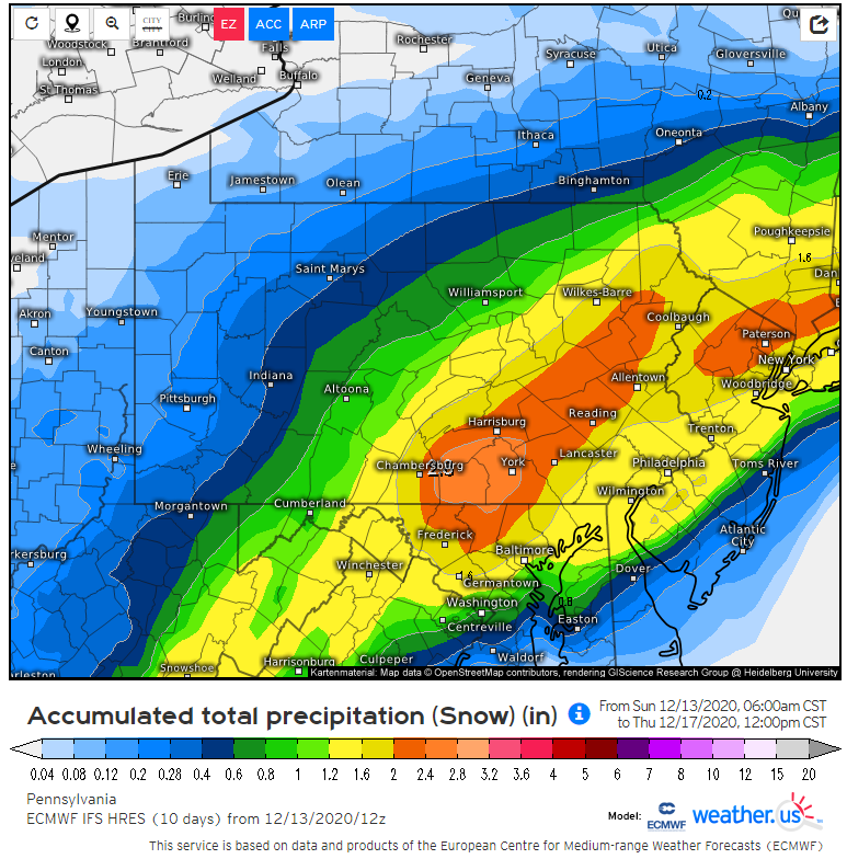
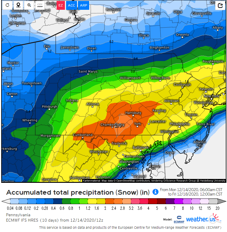
The GFS is not a good model. It’s just not, given its waffling buffoonery. (And btw, its 00z run still shows over a foot IMBY so this isn’t biased).
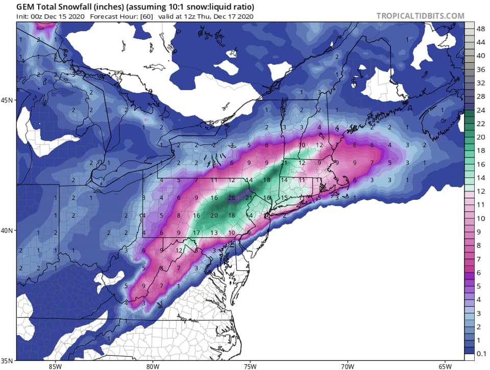
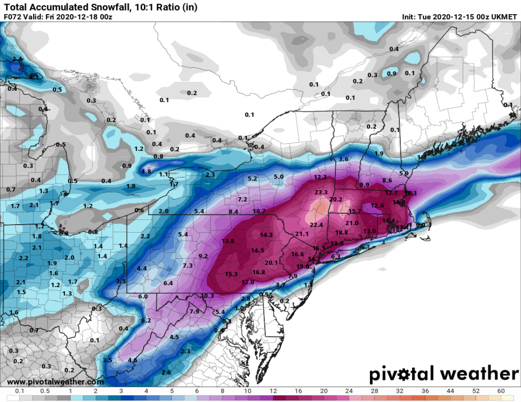
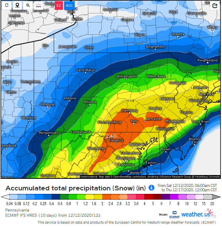
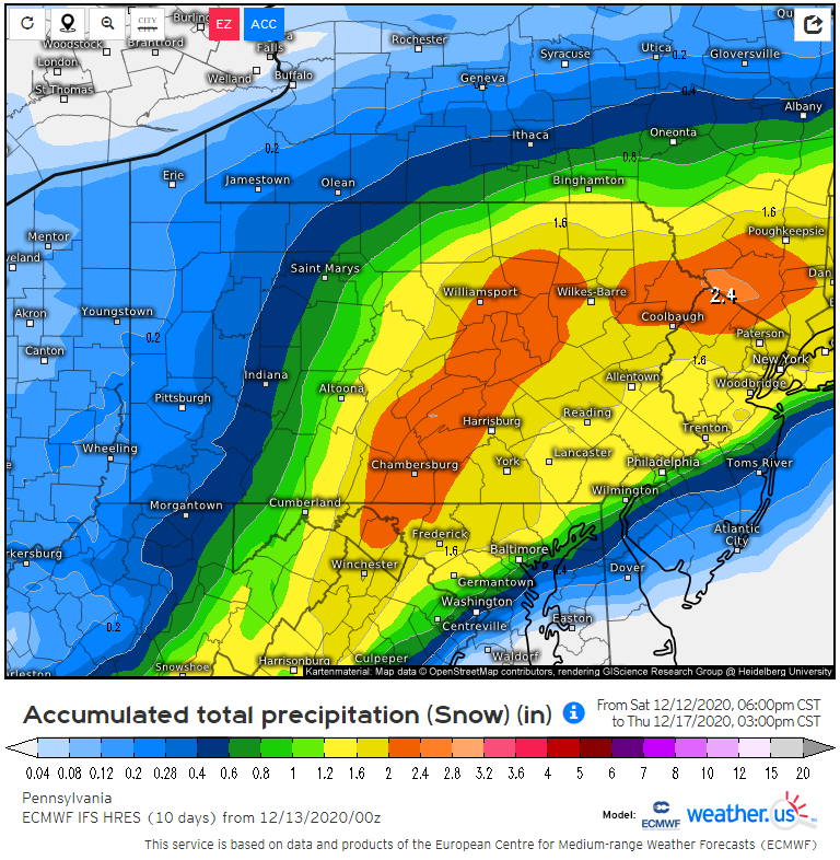
The Euro has remained decently consistent, as has Canada’s models. I’m betting on consistency.
The Euro has remained decently consistent, as has Canada’s models. I’m betting on consistency.
SoulSingMG- Senior Enthusiast

- Posts : 2853
Join date : 2013-12-11
 Re: 12/16 to 12/17 Godzilla - 1st Call Snow Map
Last few runs of the GFS for the same time stamp. In the grand scheme of it all, not a lot of change from this model. At this point it can’t be discounted, and many in the meteorological community are beginning to believe it


 Re: 12/16 to 12/17 Godzilla - 1st Call Snow Map
0z sends double digit totals into VT and torches the coast. how can these models be so far apart
_________________
-Alex Iannone-

aiannone- Senior Enthusiast - Mod

- Posts : 4815
Reputation : 92
Join date : 2013-01-07
Location : Saint James, LI (Northwest Suffolk Co.)
 Re: 12/16 to 12/17 Godzilla - 1st Call Snow Map
aiannone wrote:0z sends double digit totals into VT and torches the coast. how can these models be so far apart
It’s a conspiracy. They’re trying to make us all nuts.
_________________
_______________________________________________________________________________________________________
CLICK HERE to view NJ Strong Snowstorm Classifications
 Re: 12/16 to 12/17 Godzilla - 1st Call Snow Map
Yes Frank GFS might be on to something and it would be a downer for some here I think it could be right.
jimv45- Senior Enthusiast

- Posts : 1168
Reputation : 36
Join date : 2013-09-20
Location : Hopewell jct.
 Re: 12/16 to 12/17 Godzilla - 1st Call Snow Map
_________________
_______________________________________________________________________________________________________
CLICK HERE to view NJ Strong Snowstorm Classifications
CPcantmeasuresnow likes this post

aiannone- Senior Enthusiast - Mod

- Posts : 4815
Reputation : 92
Join date : 2013-01-07
Location : Saint James, LI (Northwest Suffolk Co.)
 Re: 12/16 to 12/17 Godzilla - 1st Call Snow Map
Remember with Stella (3/14/17), the GFS was the south-eastern most scenario for several days. It wasn't until we got much closer that it caves to the other models for a more north-west type solution.
Math23x7- Wx Statistician Guru

- Posts : 2379
Reputation : 68
Join date : 2013-01-08
CPcantmeasuresnow and rb924119 like this post

aiannone- Senior Enthusiast - Mod

- Posts : 4815
Reputation : 92
Join date : 2013-01-07
Location : Saint James, LI (Northwest Suffolk Co.)
 Re: 12/16 to 12/17 Godzilla - 1st Call Snow Map
I love the positive thinking math! This is so true too. but even CMC is i think nuts too far north too. We might just have to skip the globals tomorrow and go with the SR.Math23x7 wrote:Remember with Stella (3/14/17), the GFS was the south-eastern most scenario for several days. It wasn't until we got much closer that it caves to the other models for a more north-west type solution.

jmanley32- Senior Enthusiast

- Posts : 20535
Reputation : 108
Join date : 2013-12-12
Age : 43
Location : Yonkers, NY

jmanley32- Senior Enthusiast

- Posts : 20535
Reputation : 108
Join date : 2013-12-12
Age : 43
Location : Yonkers, NY
 Re: 12/16 to 12/17 Godzilla - 1st Call Snow Map
The GFS is stubborn but it will cave tomorrow.

hyde345- Pro Enthusiast

- Posts : 1082
Reputation : 48
Join date : 2013-01-08
Location : Hyde Park, NY
CPcantmeasuresnow likes this post
 Re: 12/16 to 12/17 Godzilla - 1st Call Snow Map
Frank_Wx wrote:Last few runs of the GFS for the same time stamp. In the grand scheme of it all, not a lot of change from this model. At this point it can’t be discounted, and many in the meteorological community are beginning to believe it
I don't know, just because its consistent doesn't mean it is right. It's done this before only to cave. The Euro and CMC have been consistent also and my money is on a blend of those models.

hyde345- Pro Enthusiast

- Posts : 1082
Reputation : 48
Join date : 2013-01-08
Location : Hyde Park, NY

SoulSingMG- Senior Enthusiast

- Posts : 2853
Reputation : 74
Join date : 2013-12-11
Location : Long Island City, NY
 Re: 12/16 to 12/17 Godzilla - 1st Call Snow Map
The entire 00Z suite came a tad further N and W except the GooFuS. That should happen tomorrow or should I say later today.

hyde345- Pro Enthusiast

- Posts : 1082
Reputation : 48
Join date : 2013-01-08
Location : Hyde Park, NY
 Re: 12/16 to 12/17 Godzilla - 1st Call Snow Map
Euro was a good hit 12-18 for most.

jmanley32- Senior Enthusiast

- Posts : 20535
Reputation : 108
Join date : 2013-12-12
Age : 43
Location : Yonkers, NY
 Re: 12/16 to 12/17 Godzilla - 1st Call Snow Map
The gfs is clearly on its own. Gn will see you all later today. Warnings prolly go up at some point.

jmanley32- Senior Enthusiast

- Posts : 20535
Reputation : 108
Join date : 2013-12-12
Age : 43
Location : Yonkers, NY
Math23x7- Wx Statistician Guru

- Posts : 2379
Reputation : 68
Join date : 2013-01-08
 Re: 12/16 to 12/17 Godzilla - 1st Call Snow Map
Also, 6Z guidance, including 12km NAM, 3km NAM, and RGEM seem to have the northwest shift as well.
Math23x7- Wx Statistician Guru

- Posts : 2379
Reputation : 68
Join date : 2013-01-08
 Re: 12/16 to 12/17 Godzilla - 1st Call Snow Map
Math23x7 wrote:Also, 6Z guidance, including 12km NAM, 3km NAM, and RGEM seem to have the northwest shift as well.
All those models show a foot of more I-80 North and away from the immediate Coast amazing how consistent to Euro has been showing a foot or more of snow for the New York metro area

algae888- Advanced Forecaster

- Posts : 5311
Reputation : 46
Join date : 2013-02-05
Age : 62
Location : mt. vernon, new york

SoulSingMG- Senior Enthusiast

- Posts : 2853
Reputation : 74
Join date : 2013-12-11
Location : Long Island City, NY
 Re: 12/16 to 12/17 Godzilla - 1st Call Snow Map
GFS has not budged for last 5 days with the track of this storm. Consistent thruought.
adamfitz1969- Posts : 122
Reputation : 14
Join date : 2018-03-01
Age : 54
Location : Tarrytown
 Re: 12/16 to 12/17 Godzilla - 1st Call Snow Map
6z GFS largely the same as it has been. In fact all the models have been (other than the NAM which underwent a big - positive for most - change yesterday afternoon) largely consistent.
If I had to summarize it would be that North Jersey is getting slammed with a massive snowstorm no matter what model you buy into as are the NW Philly burbs and immediate NYC metro.
South Jersey especially along the coast is getting a rain or a mix that severely limits accumulation.
The only two areas in question are from Philly northeast right along I-195 in central Jersey which could be all heavy snow or if the NAM is right could have significant mixing which will make a big difference; and areas farther up the Hudson Valley which could get largely cutoff and limited to light snow totals if the GFS holds.

billg315- Advanced Forecaster - Mod

- Posts : 4483
Reputation : 185
Join date : 2015-01-24
Age : 50
Location : Flemington, NJ
 Re: 12/16 to 12/17 Godzilla - 1st Call Snow Map
Mount Holly has issued Winter Storm Warnings:
WINTER STORM WARNING IN EFFECT FROM 10 AM WEDNESDAY TO 10 AMEST THURSDAY...
* WHAT...Heavy mixed precipitation expected. Total snow accumulations in excess of 12 inches along with ice accumulations of a light glaze. Winds gusting as high as 35 mph.
* WHERE...Portions of central, northern and northwest New Jersey and southeast Pennsylvania.
* WHEN...From 10 AM Wednesday to 10 AM EST Thursday.
* IMPACTS...Travel could be very difficult to impossible. The hazardous conditions could impact the evening commute on Wednesday and the morning commute on Thursday. The heavy snow could result in power outages.
* ADDITIONAL DETAILS...Snow will move in southwest to northeast late Wednesday morning into the early afternoon. The snow could become heavy at times late Wednesday afternoon into Wednesday night. There may also be some sleet and freezing rain mixed in at times. PRECAUTIONARY/PREPAREDNESS ACTIONS... If you must travel, keep an extra flashlight, food, and water in your vehicle in case of an emergency.

billg315- Advanced Forecaster - Mod

- Posts : 4483
Reputation : 185
Join date : 2015-01-24
Age : 50
Location : Flemington, NJ
 Re: 12/16 to 12/17 Godzilla - 1st Call Snow Map
This stubborn GFS is reading that high pressure which could suppress this storm much further south.Glad the other models disagree, but would like to see this cave over the next 24 hours.Bad memories of that "snowmageddon" year when NYC didn't see a flake while Philly got over 20 inches.

docstox12- Wx Statistician Guru

- Posts : 8530
Reputation : 222
Join date : 2013-01-07
Age : 73
Location : Monroe NY
 Re: 12/16 to 12/17 Godzilla - 1st Call Snow Map
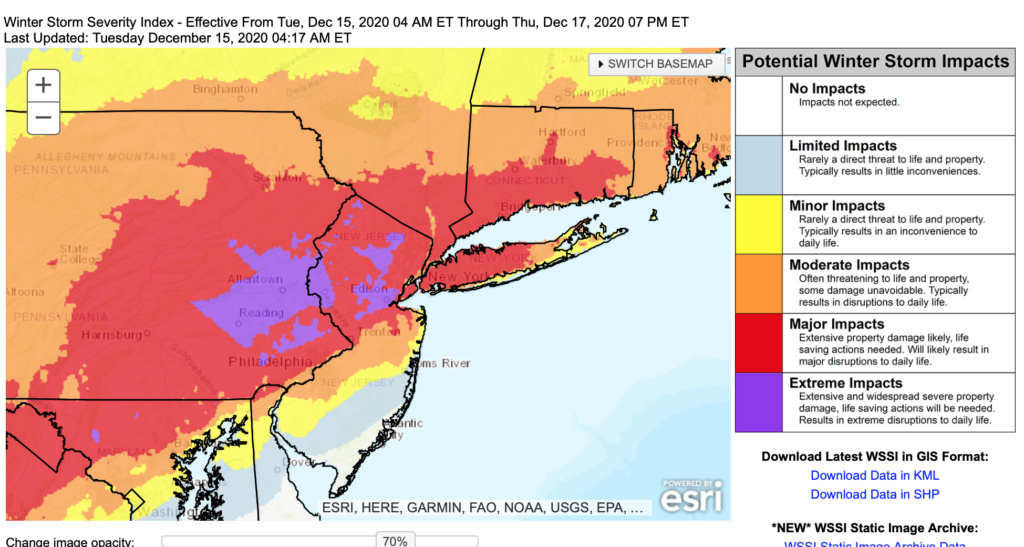
This map makes me wonder just what to expect in the areas with extreme impacts.... Also wondering about potential mixing issues in middlesex county and the impact that will have on totals
phil155- Pro Enthusiast

- Posts : 483
Reputation : 4
Join date : 2019-12-16
 Re: 12/16 to 12/17 Godzilla - 1st Call Snow Map
Looks like 6zgfs came north a fair amount actually. Most other models tucked in again ever so slightly. The subtle winshsheuld wipers as Bernie would say seem to be in effect. Slide these lines left or right by 5-10miles and you have the difference between 3-6” SE of yellow. 6”10” between yellow and blue, and 8-12” NW of blue.


_________________
"In weather and in life, there's no winning and losing; there's only winning and learning."
WINTER 2012/2013 TOTALS 43.65"WINTER 2017/2018 TOTALS 62.85" WINTER 2022/2023 TOTALS 4.9"
WINTER 2013/2014 TOTALS 64.85"WINTER 2018/2019 TOTALS 14.25" WINTER 2023/2024 TOTALS 13.1"
WINTER 2014/2015 TOTALS 71.20"WINTER 2019/2020 TOTALS 6.35"
WINTER 2015/2016 TOTALS 35.00"WINTER 2020/2021 TOTALS 37.75"
WINTER 2016/2017 TOTALS 42.25"WINTER 2021/2022 TOTALS 31.65"

sroc4- Admin

- Posts : 8354
Reputation : 302
Join date : 2013-01-07
Location : Wading River, LI
Page 2 of 12 •  1, 2, 3, ... 10, 11, 12
Page 2 of 12
Permissions in this forum:
You cannot reply to topics in this forum
 Home
Home

