12/16 to 12/17 Godzilla - 1st Call Snow Map
+40
gigs68
WeatherBob
SENJsnowman
Wheezer
Dunnzoo
nutleyblizzard
MattyICE
Irish
bloc1357
RJB8525
rb924119
bobjohnsonforthehall
essexcountypete
elkiehound
DAYBLAZER
crippo84
amugs
heehaw453
sabamfa
CPcantmeasuresnow
sroc4
phil155
docstox12
adamfitz1969
algae888
Math23x7
jimv45
weatherwatchermom
Artechmetals
SoulSingMG
mwilli
billg315
jmanley32
dsix85
Scullybutcher
oldtimer
hyde345
frank 638
aiannone
Frank_Wx
44 posters
Page 3 of 12
Page 3 of 12 •  1, 2, 3, 4 ... 10, 11, 12
 Re: 12/16 to 12/17 Godzilla - 1st Call Snow Map
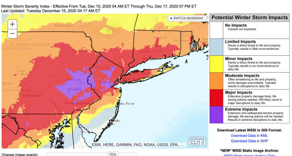
This map makes me wonder just what to expect in the areas with extreme impacts.... Also wondering about potential mixing issues in middlesex county and the impact that will have on totals
phil155- Pro Enthusiast

- Posts : 483
Join date : 2019-12-16
 Re: 12/16 to 12/17 Godzilla - 1st Call Snow Map
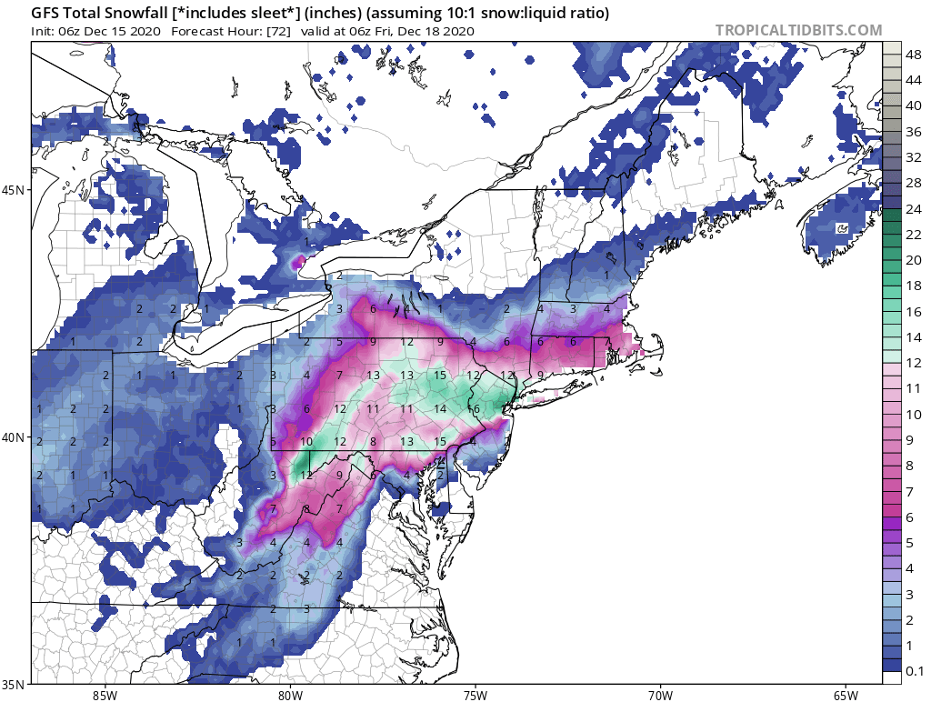
Looks like 6zgfs came north a fair amount actually. Most other models tucked in again ever so slightly. The subtle winshsheuld wipers as Bernie would say seem to be in effect. Slide these lines left or right by 5-10miles and you have the difference between 3-6” SE of yellow. 6”10” between yellow and blue, and 8-12” NW of blue.


sroc4- Admin

- Posts : 8354
Join date : 2013-01-07
 Re: 12/16 to 12/17 Godzilla - 1st Call Snow Map
docstox12 wrote:This stubborn GFS is reading that high pressure which could suppress this storm much further south.Glad the other models disagree, but would like to see this cave over the next 24 hours.Bad memories of that "snowmageddon" year when NYC didn't see a flake while Philly got over 20 inches.
GFS already making moves Doc. You see that 12 from this mornings GFS run right over Monroe/Highland Mills. We haven't seen anything close to that from GFS regarding this storm. IT even has a 6 up past Hyde and Jim where it's been insistent in past runs accumulating snows wouldn't even make it that far north.
We seem to be in a 12-24 inch range on every model now. I never spike the football until my yardstick goes in the ground to verify but after last nights 0Z suites and this mornings GFS I'm starting to breathe a little easier.
Also remember this is 10:1 ratios, in the HV ratios should be more in the 12:1 to 14:1 range.

CPcantmeasuresnow- Wx Statistician Guru

- Posts : 7274
Reputation : 230
Join date : 2013-01-07
Age : 103
Location : Eastern Orange County, NY
 Re: 12/16 to 12/17 Godzilla - 1st Call Snow Map
phil155 wrote:
This map makes me wonder just what to expect in the areas with extreme impacts.... Also wondering about potential mixing issues in middlesex county and the impact that will have on totals
Same. Looks like I’m in or bordering one of those purple areas.
sabamfa- Pro Enthusiast

- Posts : 246
Reputation : 2
Join date : 2013-11-05
Age : 38
Location : Wayne, NJ
 Re: 12/16 to 12/17 Godzilla - 1st Call Snow Map

The biggest open question is where exactly do the mid level lows track. Yesterday, they stayed south then scooted east off the coast, which allowed for heavy bands of snow to sit and rot over the area (deform). This morning, the 700mb low track right over NJ, which means dry slotting for the state including NYC on east. It also means more rain for the Jersey shore. What a huge difference! 06z euro snow map posted above
_________________
_______________________________________________________________________________________________________
CLICK HERE to view NJ Strong Snowstorm Classifications
 Re: 12/16 to 12/17 Godzilla - 1st Call Snow Map
Notice how the axis of heaviest snow moves back into central PA. Just when we thought there was some model agreement yesterday, we actually do not with about 1.5 days to go.
_________________
_______________________________________________________________________________________________________
CLICK HERE to view NJ Strong Snowstorm Classifications
 Re: 12/16 to 12/17 Godzilla - 1st Call Snow Map
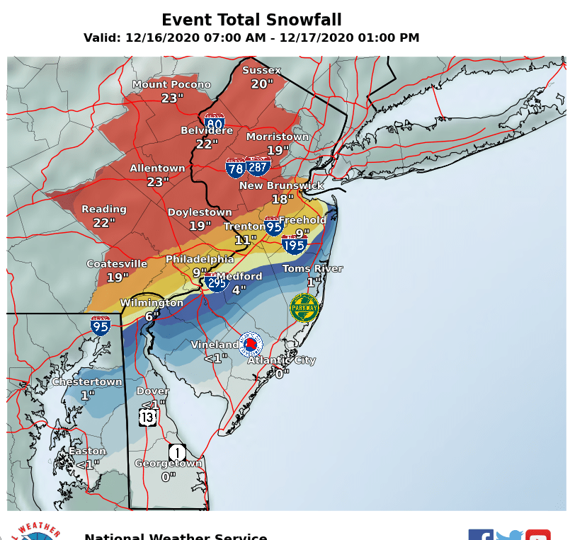
How's this for a snowfall gradient. Personally, IMBY and Lehigh Valley my over/under is 1' which is a crushing in my book and will be ecstatic for it. To render the prodigious amounts shown so much has to go right. The ULL must stay in just the right spot to the SE, no dry slotting, etc., etc.
Fun to track, but expectations are in check.
Fun to track, but expectations are in check.

heehaw453- Advanced Forecaster

- Posts : 3906
Reputation : 86
Join date : 2014-01-20
Location : Bedminster Township, PA Elevation 600' ASL
 Re: 12/16 to 12/17 Godzilla - 1st Call Snow Map
Here’s your difference. EPS vs GEFS. The low being over SNJ will mean much reduced snowfall for almost everyone on this board, exception being N&W, while GEFS outcome would give everyone a significant storm event.


_________________
_______________________________________________________________________________________________________
CLICK HERE to view NJ Strong Snowstorm Classifications
 Re: 12/16 to 12/17 Godzilla - 1st Call Snow Map
Frank_Wx wrote:Here’s your difference. EPS vs GEFS. The low being over SNJ will mean much reduced snowfall for almost everyone on this board, exception being N&W, while GEFS outcome would give everyone a significant storm event.
I would split the difference ATTM. I think Jersey coast has a decent shot of getting more than progged now. Like LBI does much better than an inch kind of thing and wind up with 4-6".
heehaw453- Advanced Forecaster

- Posts : 3906
Reputation : 86
Join date : 2014-01-20
Location : Bedminster Township, PA Elevation 600' ASL
 Re: 12/16 to 12/17 Godzilla - 1st Call Snow Map
The 6z Euro came a little Southeast 12 to 18 in for most of the tri-state area what I think it has most correct is you're not going to see one foot totals near Albany or Southern Vermont and New Hampshire very short cut off on the Northern extent

algae888- Advanced Forecaster

- Posts : 5311
Reputation : 46
Join date : 2013-02-05
Age : 62
Location : mt. vernon, new york
 Re: 12/16 to 12/17 Godzilla - 1st Call Snow Map
This is a from a met from another board he is an excellent forecaster.
I think you’re going to see a correction back southeast today as the arctic airmass that’s building into the region throughout the day begins to get ingested into the models.
The temp drops throughout the day today....
This airmass is very cold and dry as the storm approaches...DENSE.
The orientation of the high is a classic CAD over performing location for northeast/mid Atlantic...
I would strongly hedge higher than current guidance for snowfall amounts in LI/NYC area...

algae888- Advanced Forecaster

- Posts : 5311
Reputation : 46
Join date : 2013-02-05
Age : 62
Location : mt. vernon, new york
mmanisca likes this post
 Re: 12/16 to 12/17 Godzilla - 1st Call Snow Map
algae888 wrote:This is a from a met from another board he is an excellent forecaster.
I think you’re going to see a correction back southeast today as the arctic airmass that’s building into the region throughout the day begins to get ingested into the models.
The temp drops throughout the day today....
This airmass is very cold and dry as the storm approaches...DENSE.
The orientation of the high is a classic CAD over performing location for northeast/mid Atlantic...
I would strongly hedge higher than current guidance for snowfall amounts in LI/NYC area...
Al the inevitable NW ticks then to adjust SE then the track.
I just said this in a text to Mike P - adjust the models about 15-20 miles SE today and for teh storm and that is what you'll get - crippling blow could be to the City and NNJ
_________________
Mugs
AKA:King: Snow Weenie
Self Proclaimed
WINTER 2014-15 : 55.12" +.02 for 6 coatings (avg. 35")
WINTER 2015-16 Total - 29.8" (Avg 35")
WINTER 2016-17 : 39.5" so far

amugs- Advanced Forecaster - Mod

- Posts : 15095
Reputation : 213
Join date : 2013-01-07
Age : 54
Location : Hillsdale,NJ
 Re: 12/16 to 12/17 Godzilla - 1st Call Snow Map
I know this board hates to hear it, but TWC is all in on big snow into NYC metro with 12-18.
...running away now.
...running away now.
crippo84- Posts : 383
Reputation : 20
Join date : 2013-11-07
Age : 40
Location : East Village, NYC
 Re: 12/16 to 12/17 Godzilla - 1st Call Snow Map
Morning all.
Great write-up Frank, and excellent analysis all around from you guys. Makes everything easy to understand for sure.
Looking forward to the model runs today. That being said, I've consistently been in the bullseye for highest snow totals here in NW NJ.
Now, being in the bullseye this far in advance has proven disastrous in the past, so I am managing my expectations accordingly. THAT being said, I really like what I see for Sussex NJ. I can't remember being in a better spot this late in the game.

DAYBLAZER- Posts : 228
Reputation : 20
Join date : 2017-03-12
Location : Hopatcong, NJ Sussex County
 Re: 12/16 to 12/17 Godzilla - 1st Call Snow Map
Okay so GFS finally caves but very concerning the SR models are now coming way far NW heaviest snows far far north. Looks like could even rain at coast?! Thought a? Northern people if the SR holds you guys may be the jackpot.

jmanley32- Senior Enthusiast

- Posts : 20535
Reputation : 108
Join date : 2013-12-12
Age : 43
Location : Yonkers, NY
heehaw453- Advanced Forecaster

- Posts : 3906
Reputation : 86
Join date : 2014-01-20
Location : Bedminster Township, PA Elevation 600' ASL
 Re: 12/16 to 12/17 Godzilla - 1st Call Snow Map
what exactly is it saying extreme property damage in red and purple? From winds? Snow causing damage?sabamfa wrote:phil155 wrote:
This map makes me wonder just what to expect in the areas with extreme impacts.... Also wondering about potential mixing issues in middlesex county and the impact that will have on totals
Same. Looks like I’m in or bordering one of those purple areas.

jmanley32- Senior Enthusiast

- Posts : 20535
Reputation : 108
Join date : 2013-12-12
Age : 43
Location : Yonkers, NY
 Re: 12/16 to 12/17 Godzilla - 1st Call Snow Map
Will this be wet and heavy or light and fluffy (Hunterdon county)? Thx

elkiehound- Posts : 56
Reputation : 1
Join date : 2013-12-09
Location : Ringoes NJ
 Re: 12/16 to 12/17 Godzilla - 1st Call Snow Map
crippo84 wrote:I know this board hates to hear it, but TWC is all in on big snow into NYC metro with 12-18.
...running away now.
They have me at 7 - 14 now
Scullybutcher- Pro Enthusiast

- Posts : 543
Reputation : 16
Join date : 2013-02-06
Location : North Smithtown, western Suffolk county, long island
 Re: 12/16 to 12/17 Godzilla - 1st Call Snow Map
jmanley32 wrote:what exactly is it saying extreme property damage in red and purple? From winds? Snow causing damage?sabamfa wrote:phil155 wrote:
This map makes me wonder just what to expect in the areas with extreme impacts.... Also wondering about potential mixing issues in middlesex county and the impact that will have on totals
Same. Looks like I’m in or bordering one of those purple areas.
Just wondering the same thing jman. I read it out loud to my wife and were both like "Wahhhh"! It's worded in a way that seems more appropriate for a hurricane that a winter storm, and it seems a tad bit overblown.

essexcountypete- Pro Enthusiast

- Posts : 783
Reputation : 12
Join date : 2013-12-09
Location : Bloomfield, NJ

aiannone- Senior Enthusiast - Mod

- Posts : 4815
Reputation : 92
Join date : 2013-01-07
Location : Saint James, LI (Northwest Suffolk Co.)
 Re: 12/16 to 12/17 Godzilla - 1st Call Snow Map
yikes. Windshield wiper effect?
Now someone post another model that shows the opposite. Please (lol)
Now someone post another model that shows the opposite. Please (lol)

DAYBLAZER- Posts : 228
Reputation : 20
Join date : 2017-03-12
Location : Hopatcong, NJ Sussex County
 Re: 12/16 to 12/17 Godzilla - 1st Call Snow Map
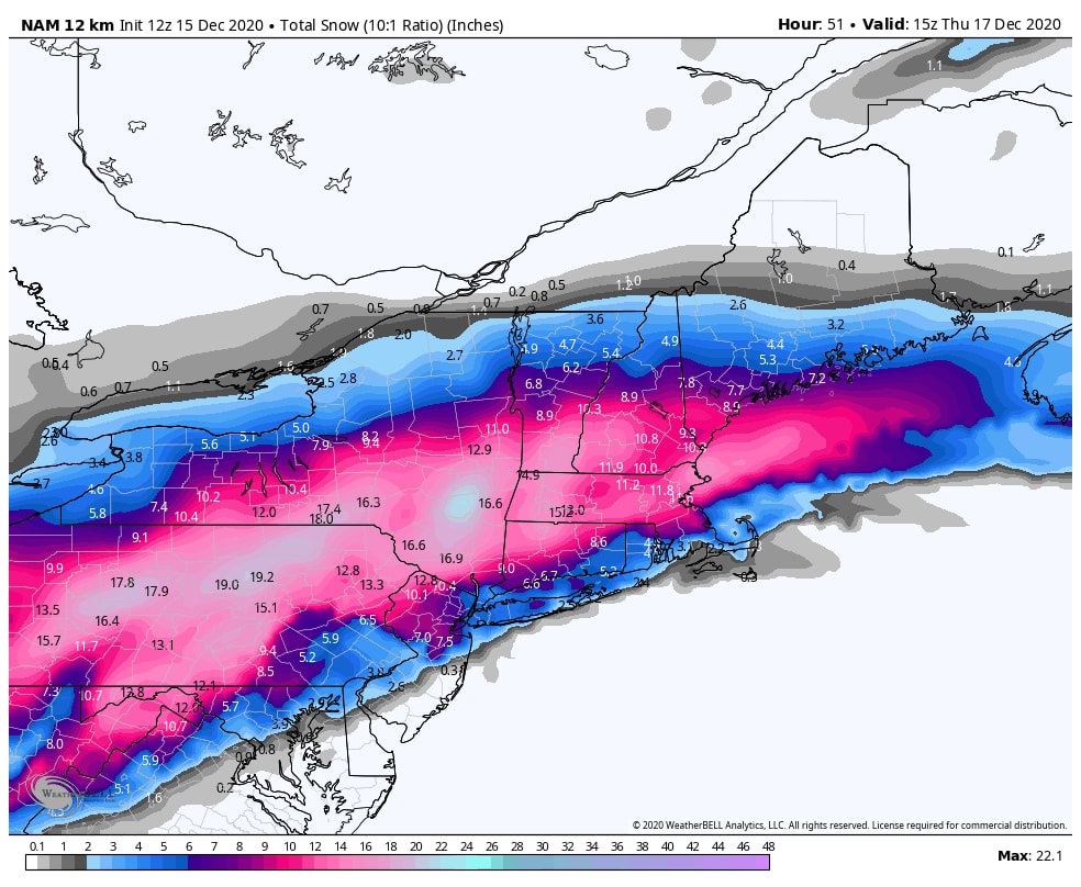
If the lows (700/850) track that far north as shown by NAM then a lot of folks will be dry slotted and taint with sleet. This is NAM out of its good range, but nonetheless it's possible.
I guess the all bets are still on the table.
I guess the all bets are still on the table.
Last edited by heehaw453 on Tue Dec 15, 2020 9:30 am; edited 1 time in total
heehaw453- Advanced Forecaster

- Posts : 3906
Reputation : 86
Join date : 2014-01-20
Location : Bedminster Township, PA Elevation 600' ASL

SoulSingMG- Senior Enthusiast

- Posts : 2853
Reputation : 74
Join date : 2013-12-11
Location : Long Island City, NY
 Re: 12/16 to 12/17 Godzilla - 1st Call Snow Map
It's amazing. In the span of 12 hours, we have worries about suppression and worries about the lows getting TOO far north....

DAYBLAZER- Posts : 228
Reputation : 20
Join date : 2017-03-12
Location : Hopatcong, NJ Sussex County
CPcantmeasuresnow likes this post
 Re: 12/16 to 12/17 Godzilla - 1st Call Snow Map
Where is RB? the Nam plus others may be on to what he said might happen!!!
jimv45- Senior Enthusiast

- Posts : 1168
Reputation : 36
Join date : 2013-09-20
Location : Hopewell jct.
 Re: 12/16 to 12/17 Godzilla - 1st Call Snow Map
It's one model run, as Aaron Rodgers so perfectly said.. "R-E-L-A-XXXXXXXXXXXXXXX"
dsix85- Pro Enthusiast

- Posts : 349
Reputation : 8
Join date : 2014-01-01
Location : New York
RJB8525 and SoulSingMG like this post
Page 3 of 12 •  1, 2, 3, 4 ... 10, 11, 12
Page 3 of 12
Permissions in this forum:
You cannot reply to topics in this forum
 Home
Home