
 Search
12/16 to 12/17 Godzilla - 1st Call Snow Map
Page 11 of 12 •  1, 2, 3 ... , 10, 11, 12
 ![]()
Re: 12/16 to 12/17 Godzilla - 1st Call Snow Map
![]() by jmanley32 Tue Dec 15, 2020 5:28 pm
by jmanley32 Tue Dec 15, 2020 5:28 pm
yeah not look forward to that that's how I broke my bumper on my last car. Need get a trowel or metal postamugs wrote:The GEFS have not 2averes from 6 or 12 Z. Its mean has been basically the same with an inch of two each time across the area for snow.
The LP placement has again been within normal wobbles. The OP has been up down and all around, like so many weenies.
Again the cold is dense and a 1039 HP is mint. What till the snowpack sets in and the low temps turn tnis into a block of ice when we are in the teens to single digits. Thats for after the storm.
jmanley32- Senior Enthusiast

- Posts : 20535
Join date : 2013-12-12
RJB8525 likes this post
Re: 12/16 to 12/17 Godzilla - 1st Call Snow Map
![]() by amugs Tue Dec 15, 2020 5:39 pm
by amugs Tue Dec 15, 2020 5:39 pm


amugs- Advanced Forecaster - Mod

- Posts : 15095
Join date : 2013-01-07

heehaw453- Advanced Forecaster

- Posts : 3906
Reputation : 86
Join date : 2014-01-20
Location : Bedminster Township, PA Elevation 600' ASL
Re: 12/16 to 12/17 Godzilla - 1st Call Snow Map
![]() by jimv45 Tue Dec 15, 2020 5:54 pm
by jimv45 Tue Dec 15, 2020 5:54 pm
jimv45- Senior Enthusiast
- Posts : 1168
Reputation : 36
Join date : 2013-09-20
Location : Hopewell jct.
Re: 12/16 to 12/17 Godzilla - 1st Call Snow Map
![]() by amugs Tue Dec 15, 2020 5:57 pm
by amugs Tue Dec 15, 2020 5:57 pm
_________________
Mugs
AKA:King: Snow Weenie
Self Proclaimed
WINTER 2014-15 : 55.12" +.02 for 6 coatings (avg. 35")
WINTER 2015-16 Total - 29.8" (Avg 35")
WINTER 2016-17 : 39.5" so far

amugs- Advanced Forecaster - Mod
- Posts : 15095
Reputation : 213
Join date : 2013-01-07
Age : 54
Location : Hillsdale,NJ
Re: 12/16 to 12/17 Godzilla - 1st Call Snow Map
![]() by hurrysundown23 Tue Dec 15, 2020 6:16 pm
by hurrysundown23 Tue Dec 15, 2020 6:16 pm
Point Forecast:Parlin NJ
40.46°N 74.3°W (Elev. 98 ft)
Last Update:4:28 pm EST Dec 15, 2020
Forecast Valid:6pm EST Dec 15, 2020-6pm EST Dec 22, 2020
Detailed Forecast
TonightPartly cloudy, with a low around 22. North wind 5 to 10 mph.
WednesdaySnow likely, mainly after 4pm. The snow could be heavy at times. Mostly cloudy, with a high near 34. Northeast wind 5 to 15 mph. Chance of precipitation is 60%. New snow accumulation of 1 to 2 inches possible.
Wednesday NightSnow before 1am, then snow and sleet. The snow and sleet could be heavy at times. Low around 29. Blustery, with a northeast wind 20 to 25 mph, with gusts as high as 40 mph. Chance of precipitation is 100%. New snow and sleet accumulation of 6 to 10 inches possible.
ThursdaySnow, mainly before 8am. High near 34. Breezy, with a north wind 20 to 25 mph decreasing to 10 to 15 mph in the afternoon. Winds could gust as high as 35 mph. Chance of precipitation is 80%. New snow accumulation of 1 to 3 inches possible.
hurrysundown23- Posts : 53
Reputation : 1
Join date : 2017-01-04
Location : Sayreville, NJ
Re: 12/16 to 12/17 Godzilla - 1st Call Snow Map
![]() by aiannone Tue Dec 15, 2020 6:17 pm
by aiannone Tue Dec 15, 2020 6:17 pm
_________________
-Alex Iannone-

aiannone- Senior Enthusiast - Mod
- Posts : 4815
Reputation : 92
Join date : 2013-01-07
Location : Saint James, LI (Northwest Suffolk Co.)
sroc4, amugs, RJB8525, bloc1357, sabamfa and Irish like this post
Re: 12/16 to 12/17 Godzilla - 1st Call Snow Map
![]() by SoulSingMG Tue Dec 15, 2020 6:21 pm
by SoulSingMG Tue Dec 15, 2020 6:21 pm
aiannone wrote:There will be a SE trend tonight on 0z. Why you ask?I walked out of work and a shooting star went right over my head. I wished for it. Simple enough, old fashioned way.
That was just me on my broom, pushing the confluence south!

SoulSingMG- Senior Enthusiast
- Posts : 2853
Reputation : 74
Join date : 2013-12-11
Location : Long Island City, NY
sabamfa likes this post
Re: 12/16 to 12/17 Godzilla - 1st Call Snow Map
![]() by jmanley32 Tue Dec 15, 2020 6:26 pm
by jmanley32 Tue Dec 15, 2020 6:26 pm
priceless lolSoulSingMG wrote:aiannone wrote:There will be a SE trend tonight on 0z. Why you ask?I walked out of work and a shooting star went right over my head. I wished for it. Simple enough, old fashioned way.
That was just me on my broom, pushing the confluence south!

jmanley32- Senior Enthusiast
- Posts : 20535
Reputation : 108
Join date : 2013-12-12
Age : 43
Location : Yonkers, NY
SoulSingMG likes this post
Re: 12/16 to 12/17 Godzilla - 1st Call Snow Map
![]() by frank 638 Tue Dec 15, 2020 6:28 pm
by frank 638 Tue Dec 15, 2020 6:28 pm
Lonnie Quinn and yes his sleeves Were up .for the city 5 to 10 inches of snow
Janice 8 to 12
Nick Gregory 6 to 10
Lee Goldberg 6 to 12
frank 638- Senior Enthusiast
- Posts : 2843
Reputation : 37
Join date : 2016-01-01
Age : 40
Location : bronx ny
Re: 12/16 to 12/17 Godzilla - 1st Call Snow Map
![]() by jmanley32 Tue Dec 15, 2020 6:28 pm
by jmanley32 Tue Dec 15, 2020 6:28 pm
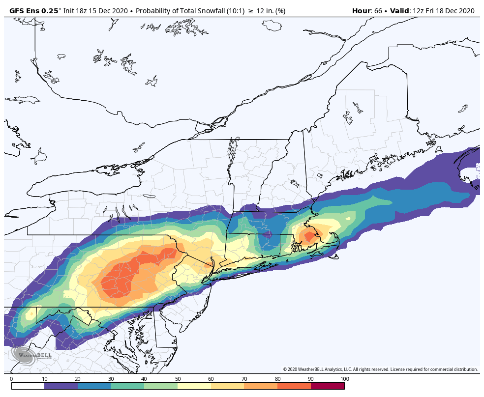
I'm like on the northern side of the red but kinda in it so I'll be on edge. I like epawa map 10 to 15 plus. I'll take it any day. We can't be expecting 20 to 24 not near coast but as Al said 10 to 15 for this area is not common and a good storm.amugs wrote:Front Genesis is where its going to pour snow and its just north of the deep red on this map
jmanley32- Senior Enthusiast
- Posts : 20535
Reputation : 108
Join date : 2013-12-12
Age : 43
Location : Yonkers, NY
Re: 12/16 to 12/17 Godzilla - 1st Call Snow Map
![]() by richb521 Tue Dec 15, 2020 6:29 pm
by richb521 Tue Dec 15, 2020 6:29 pm
When the going gets tough, the confluence gets going!
richb521- Posts : 61
Reputation : 3
Join date : 2014-01-19
Age : 50
Location : Hillsborough, NJ
Re: 12/16 to 12/17 Godzilla - 1st Call Snow Map
![]() by jmanley32 Tue Dec 15, 2020 6:31 pm
by jmanley32 Tue Dec 15, 2020 6:31 pm
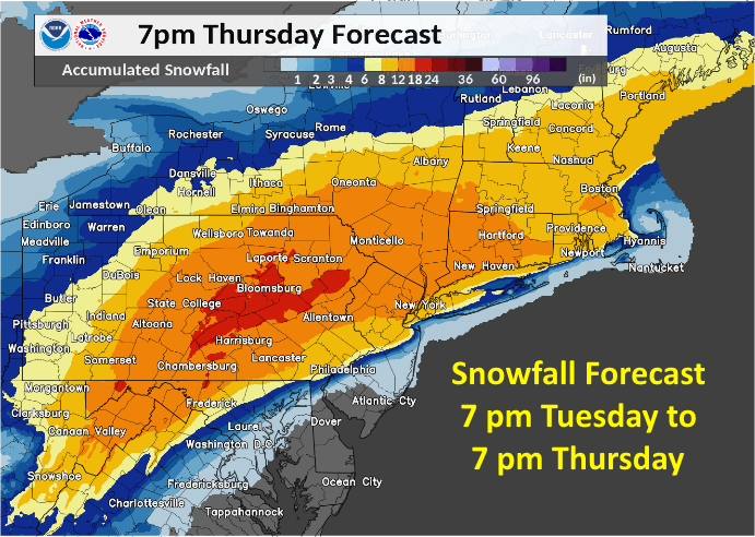
those all seem low especially if we see any south move tonight. The lower end I mean. A foot seems likely city north.frank 638 wrote:Just got through watching every weather report from Different stations this is what they came up with
Lonnie Quinn and yes his sleeves Were up .for the city 5 to 10 inches of snow
Janice 8 to 12
Nick Gregory 6 to 10
Lee Goldberg 6 to 12
jmanley32- Senior Enthusiast
- Posts : 20535
Reputation : 108
Join date : 2013-12-12
Age : 43
Location : Yonkers, NY
Re: 12/16 to 12/17 Godzilla - 1st Call Snow Map
![]() by amugs Tue Dec 15, 2020 6:45 pm
by amugs Tue Dec 15, 2020 6:45 pm
They are collecting data that will help the models hopefully nail the track of tomorrow's nor'easter!
[url=https://twitter.com/AWxNYC/status/1338982118089744396?s=20]https://twitter.com/AWxNYC/status/1338982118089744396?s=20[/url]
_________________
Mugs
AKA:King: Snow Weenie
Self Proclaimed
WINTER 2014-15 : 55.12" +.02 for 6 coatings (avg. 35")
WINTER 2015-16 Total - 29.8" (Avg 35")
WINTER 2016-17 : 39.5" so far
amugs- Advanced Forecaster - Mod
- Posts : 15095
Reputation : 213
Join date : 2013-01-07
Age : 54
Location : Hillsdale,NJ
Re: 12/16 to 12/17 Godzilla - 1st Call Snow Map
![]() by aiannone Tue Dec 15, 2020 6:53 pm
by aiannone Tue Dec 15, 2020 6:53 pm
amugs wrote:This is not a drill, the Hurricane Hunters are flying through the Gulf right now! Airplane
They are collecting data that will help the models hopefully nail the track of tomorrow's nor'easter!
[url=https://twitter.com/AWxNYC/status/1338982118089744396?s=20]https://twitter.com/AWxNYC/status/1338982118089744396?s=20[/url]
Will they be in the 0z runs?
_________________
-Alex Iannone-
aiannone- Senior Enthusiast - Mod
- Posts : 4815
Reputation : 92
Join date : 2013-01-07
Location : Saint James, LI (Northwest Suffolk Co.)
Re: 12/16 to 12/17 Godzilla - 1st Call Snow Map
![]() by amugs Tue Dec 15, 2020 6:54 pm
by amugs Tue Dec 15, 2020 6:54 pm
aiannone wrote:amugs wrote:This is not a drill, the Hurricane Hunters are flying through the Gulf right now! Airplane
They are collecting data that will help the models hopefully nail the track of tomorrow's nor'easter!
[url=https://twitter.com/AWxNYC/status/1338982118089744396?s=20]https://twitter.com/AWxNYC/status/1338982118089744396?s=20[/url]
Will they be in the 0z runs?
I would think so and definitely in the 6Z runs
_________________
Mugs
AKA:King: Snow Weenie
Self Proclaimed
WINTER 2014-15 : 55.12" +.02 for 6 coatings (avg. 35")
WINTER 2015-16 Total - 29.8" (Avg 35")
WINTER 2016-17 : 39.5" so far
amugs- Advanced Forecaster - Mod
- Posts : 15095
Reputation : 213
Join date : 2013-01-07
Age : 54
Location : Hillsdale,NJ
Re: 12/16 to 12/17 Godzilla - 1st Call Snow Map
![]() by amugs Tue Dec 15, 2020 7:08 pm
by amugs Tue Dec 15, 2020 7:08 pm
_________________
Mugs
AKA:King: Snow Weenie
Self Proclaimed
WINTER 2014-15 : 55.12" +.02 for 6 coatings (avg. 35")
WINTER 2015-16 Total - 29.8" (Avg 35")
WINTER 2016-17 : 39.5" so far
amugs- Advanced Forecaster - Mod
- Posts : 15095
Reputation : 213
Join date : 2013-01-07
Age : 54
Location : Hillsdale,NJ
Re: 12/16 to 12/17 Godzilla - 1st Call Snow Map
![]() by jmanley32 Tue Dec 15, 2020 7:14 pm
by jmanley32 Tue Dec 15, 2020 7:14 pm
wow that's expensive and unusual. Exciting.amugs wrote:aiannone wrote:amugs wrote:This is not a drill, the Hurricane Hunters are flying through the Gulf right now! Airplane
They are collecting data that will help the models hopefully nail the track of tomorrow's nor'easter!
[url=https://twitter.com/AWxNYC/status/1338982118089744396?s=20]https://twitter.com/AWxNYC/status/1338982118089744396?s=20[/url]
Will they be in the 0z runs?
I would think so and definitely in the 6Z runs
jmanley32- Senior Enthusiast
- Posts : 20535
Reputation : 108
Join date : 2013-12-12
Age : 43
Location : Yonkers, NY
Re: 12/16 to 12/17 Godzilla - 1st Call Snow Map
![]() by nutleyblizzard Tue Dec 15, 2020 7:20 pm
by nutleyblizzard Tue Dec 15, 2020 7:20 pm

18z Euro holds serve

nutleyblizzard- Senior Enthusiast
- Posts : 1954
Reputation : 41
Join date : 2014-01-30
Age : 58
Location : Nutley, new jersey
CPcantmeasuresnow and bloc1357 like this post
Re: 12/16 to 12/17 Godzilla - 1st Call Snow Map
![]() by billg315 Tue Dec 15, 2020 7:25 pm
by billg315 Tue Dec 15, 2020 7:25 pm
jmanley32 wrote:wow that's expensive and unusual. Exciting.amugs wrote:aiannone wrote:amugs wrote:This is not a drill, the Hurricane Hunters are flying through the Gulf right now! Airplane
They are collecting data that will help the models hopefully nail the track of tomorrow's nor'easter!
[url=https://twitter.com/AWxNYC/status/1338982118089744396?s=20]https://twitter.com/AWxNYC/status/1338982118089744396?s=20[/url]
Will they be in the 0z runs?
I would think so and definitely in the 6Z runs
Just saw an interesting discussion of this on TWC. They noted how, unlike in a Hurricane, they aren't flying into the storm (now over the Plains) but are flying over the Gulf of Mexico to get data from over the water there that they usually wouldn't get into the models.

billg315- Advanced Forecaster - Mod
- Posts : 4483
Reputation : 185
Join date : 2015-01-24
Age : 50
Location : Flemington, NJ
Re: 12/16 to 12/17 Godzilla - 1st Call Snow Map
![]() by amugs Tue Dec 15, 2020 7:37 pm
by amugs Tue Dec 15, 2020 7:37 pm
_________________
Mugs
AKA:King: Snow Weenie
Self Proclaimed
WINTER 2014-15 : 55.12" +.02 for 6 coatings (avg. 35")
WINTER 2015-16 Total - 29.8" (Avg 35")
WINTER 2016-17 : 39.5" so far
amugs- Advanced Forecaster - Mod
- Posts : 15095
Reputation : 213
Join date : 2013-01-07
Age : 54
Location : Hillsdale,NJ
Re: 12/16 to 12/17 Godzilla - 1st Call Snow Map
![]() by rb924119 Tue Dec 15, 2020 8:33 pm
by rb924119 Tue Dec 15, 2020 8:33 pm
WeatherBob wrote:I have a question , doesn’t, it seem that the models are not picking up the cold air damning down the east side of the of the Appalachian Mtns? I know this isn’t, a classic set up but it just looks strange on these models. 1038 high not moving to fast north of Maine and cold dry dense air now plunging south. Rb? Frank?
So, this is kind of a two-part answer. First, the high is retreating, not attacking. This makes a difference in the depth and effectiveness of the low-level cold transport, as attacking highs have more “oomph” with them. Think of momentum. Where are the worst winds/surge in a hurricane? Typically the southeastern quadrant because you have the actual wind speed combined with the forward momentum of the storm itself. Contrarily, the least surge/wind are on the northwestern side for the opposite reasons (wind against storm motion). Same idea with here with an attacking high, where the cold push is aided by the momentum of the incoming high, versus a retreating high where the cold push has to fight the momentum of the departing high.
Secondly, the lower- and mid-level lows are tracking basically over or even north/west of our area, which helps maximize warm air advection aloft. So even though you may be below freezing at the surface, you may be hitting 33-34° somewhere above you, thereby changing your observed precipitation type. These warm surges aloft are almost ALWAYS under-modeled, especially in situations where warmth is “favored”, like this one is.
rb924119- Meteorologist

- Posts : 6928
Reputation : 194
Join date : 2013-02-06
Age : 32
Location : Greentown, Pa
phil155 likes this post
Re: 12/16 to 12/17 Godzilla - 1st Call Snow Map
![]() by jaydoy Tue Dec 15, 2020 9:01 pm
by jaydoy Tue Dec 15, 2020 9:01 pm
jaydoy- Posts : 23
Reputation : 1
Join date : 2019-01-23
Re: 12/16 to 12/17 Godzilla - 1st Call Snow Map
![]() by SoulSingMG Tue Dec 15, 2020 9:17 pm
by SoulSingMG Tue Dec 15, 2020 9:17 pm
SoulSingMG- Senior Enthusiast
- Posts : 2853
Reputation : 74
Join date : 2013-12-11
Location : Long Island City, NY
deadrabbit79 likes this post
Re: 12/16 to 12/17 Godzilla - 1st Call Snow Map
![]() by heehaw453 Tue Dec 15, 2020 10:48 pm
by heehaw453 Tue Dec 15, 2020 10:48 pm
heehaw453- Advanced Forecaster
- Posts : 3906
Reputation : 86
Join date : 2014-01-20
Location : Bedminster Township, PA Elevation 600' ASL
rb924119 likes this post
Re: 12/16 to 12/17 Godzilla - 1st Call Snow Map
![]() by billg315 Tue Dec 15, 2020 11:00 pm
by billg315 Tue Dec 15, 2020 11:00 pm
heehaw453 wrote:0Z GFS was solid. 850/700 mb lows pass around NYC. Much better for thermals. Someone is probably getting dry slotted tomorrow due the track of the lows.
We were just looking at that dry slot possibility on the GFS on the chat. Unfortunately on the 0z GFS it's in my neck of the woods (probably from about Bucks County PA into Hunterdon County NJ. Not that this will necessarily be exactly where it ends up, but it would be my luck.
billg315- Advanced Forecaster - Mod
- Posts : 4483
Reputation : 185
Join date : 2015-01-24
Age : 50
Location : Flemington, NJ
Re: 12/16 to 12/17 Godzilla - 1st Call Snow Map
![]() by Zhukov1945 Tue Dec 15, 2020 11:04 pm
by Zhukov1945 Tue Dec 15, 2020 11:04 pm
billg315 wrote:heehaw453 wrote:0Z GFS was solid. 850/700 mb lows pass around NYC. Much better for thermals. Someone is probably getting dry slotted tomorrow due the track of the lows.
We were just looking at that dry slot possibility on the GFS on the chat. Unfortunately on the 0z GFS it's in my neck of the woods (probably from about Bucks County PA into Hunterdon County NJ. Not that this will necessarily be exactly where it ends up, but it would be my luck.
Feeling the same thing up by Clinton NJ

Zhukov1945- Posts : 138
Reputation : 8
Join date : 2018-03-21
Location : Clinton Township NJ
Page 11 of 12 • 1, 2, 3 ... , 10, 11, 12 ![]()