
 Search
12/16 to 12/17 Godzilla - 1st Call Snow Map
Page 10 of 12 •  1, 2, 3 ... 9, 10, 11, 12
 ![]()
Re: 12/16 to 12/17 Godzilla - 1st Call Snow Map
![]() by jmanley32 Tue Dec 15, 2020 3:56 pm
by jmanley32 Tue Dec 15, 2020 3:56 pm
that now matches with Upton side. better sensical puzzle.RJB8525 wrote:

jmanley32- Senior Enthusiast

- Posts : 20535
Join date : 2013-12-12
RJB8525 likes this post
Re: 12/16 to 12/17 Godzilla - 1st Call Snow Map
![]() by algae888 Tue Dec 15, 2020 3:57 pm
by algae888 Tue Dec 15, 2020 3:57 pm
That is a reasonable responsible and knowledgeable forecast those are meteorologist who know their geographic location and how this type of setup usually plays out even if they're off by 4 or 5 in it's still a significant event kudos to themRJB8525 wrote:
algae888- Advanced Forecaster

- Posts : 5311
Join date : 2013-02-05
Re: 12/16 to 12/17 Godzilla - 1st Call Snow Map
![]() by jmanley32 Tue Dec 15, 2020 3:58 pm
by jmanley32 Tue Dec 15, 2020 3:58 pm
Do you believe that we get 12-16? just a hour ago you said 6-12, so your agree with NWS now? It still seems kinda up in the air a bit but glad to hear we can easily get at least 6 in maybe double that b4 any change and then back end. Is there anyway we do not dry slot?algae888 wrote:jmanley32 wrote:Upton just issued warnings, Im rather shocked its for 12-16 inches. they mention heavy wet snow 45mph winds and power outages.
Yeah John they're not buying the short-range models. 7 p.m. tomorrow night per nam dew points below zero in the Hudson Valley and most of Connecticut and in the teens where we live that's not being overcome very easily I don't care how strong the low pressure is. This is an easy 6 in front end thump and I mean easy could easily get to a foot before any dry slot gets in here and then more snows on the back end good call by them

jmanley32- Senior Enthusiast
- Posts : 20535
Reputation : 108
Join date : 2013-12-12
Age : 43
Location : Yonkers, NY
Re: 12/16 to 12/17 Godzilla - 1st Call Snow Map
![]() by algae888 Tue Dec 15, 2020 4:02 pm
by algae888 Tue Dec 15, 2020 4:02 pm
jmanley32 wrote:Do you believe that we get 12-16? just a hour ago you said 6-12, so your agree with NWS now? It still seems kinda up in the air a bit but glad to hear we can easily get at least 6 in maybe double that b4 any change and then back end. Is there anyway we do not dry slot?algae888 wrote:jmanley32 wrote:Upton just issued warnings, Im rather shocked its for 12-16 inches. they mention heavy wet snow 45mph winds and power outages.
Yeah John they're not buying the short-range models. 7 p.m. tomorrow night per nam dew points below zero in the Hudson Valley and most of Connecticut and in the teens where we live that's not being overcome very easily I don't care how strong the low pressure is. This is an easy 6 in front end thump and I mean easy could easily get to a foot before any dry slot gets in here and then more snows on the back end good call by them
My gut amd past history tells me this is 12 plus in
is a good forecast but you can't deny what happened on the models today especially the short-term ones so you have to give a little hesitation.

algae888- Advanced Forecaster
- Posts : 5311
Reputation : 46
Join date : 2013-02-05
Age : 62
Location : mt. vernon, new york
Re: 12/16 to 12/17 Godzilla - 1st Call Snow Map
![]() by jmanley32 Tue Dec 15, 2020 4:05 pm
by jmanley32 Tue Dec 15, 2020 4:05 pm
jmanley32- Senior Enthusiast
- Posts : 20535
Reputation : 108
Join date : 2013-12-12
Age : 43
Location : Yonkers, NY
Re: 12/16 to 12/17 Godzilla - 1st Call Snow Map
![]() by jmanley32 Tue Dec 15, 2020 4:06 pm
by jmanley32 Tue Dec 15, 2020 4:06 pm
Oh I am, not going to make any expectations so im happy with whatever I get unless its nearly nothing or rain (which is highly unlikely), lets just see how it unfolds.algae888 wrote:jmanley32 wrote:Do you believe that we get 12-16? just a hour ago you said 6-12, so your agree with NWS now? It still seems kinda up in the air a bit but glad to hear we can easily get at least 6 in maybe double that b4 any change and then back end. Is there anyway we do not dry slot?algae888 wrote:jmanley32 wrote:Upton just issued warnings, Im rather shocked its for 12-16 inches. they mention heavy wet snow 45mph winds and power outages.
Yeah John they're not buying the short-range models. 7 p.m. tomorrow night per nam dew points below zero in the Hudson Valley and most of Connecticut and in the teens where we live that's not being overcome very easily I don't care how strong the low pressure is. This is an easy 6 in front end thump and I mean easy could easily get to a foot before any dry slot gets in here and then more snows on the back end good call by them
My gut amd past history tells me this is 12 plus in
is a good forecast but you can't deny what happened on the models today especially the short-term ones so you have to give a little hesitation.
jmanley32- Senior Enthusiast
- Posts : 20535
Reputation : 108
Join date : 2013-12-12
Age : 43
Location : Yonkers, NY
Re: 12/16 to 12/17 Godzilla - 1st Call Snow Map
![]() by WeatherBob Tue Dec 15, 2020 4:17 pm
by WeatherBob Tue Dec 15, 2020 4:17 pm

WeatherBob- Meteorologist

- Posts : 683
Reputation : 83
Join date : 2013-12-13
Location : Caldwell, NJ - NW Essex County - Altitude 500 FT
Re: 12/16 to 12/17 Godzilla - 1st Call Snow Map
![]() by jimv45 Tue Dec 15, 2020 4:19 pm
by jimv45 Tue Dec 15, 2020 4:19 pm
jimv45- Senior Enthusiast
- Posts : 1168
Reputation : 36
Join date : 2013-09-20
Location : Hopewell jct.
CPcantmeasuresnow likes this post
Re: 12/16 to 12/17 Godzilla - 1st Call Snow Map
![]() by amugs Tue Dec 15, 2020 4:21 pm
by amugs Tue Dec 15, 2020 4:21 pm

After waking up and seeing the models overnight I knew it was going to be one of those days. .
AS stated numerous times it is a heck of a set up. That 50/50 low is tremendous and it is sliding out a bit - these events always come in a bit faster than called and move out faster.
Their seems to be a consensus that the NW trend did occur no denying that but that it will tick SE as I said this morning, so the bleeding looks to have stopped from that.
That 1039 HP over Quebec was a 1032 two days ago and now is a 1039 - you are not ramming a 998 LP into that block NO WAY!! So it will take teh path of least resistance as Nature will always do and once it gains a certain latitude it will get shoved east. DO NOT UNDERSTIMATE THE POWER OF AN ARCTIC HP - This one came straight out of the Canadian NW Arctic.
So we have a Godzilla storm peeps and let's enjoy that fact and......Xmas treat in the works peeps. That is for LR thread but possibility is there.
A S/SE trend still possible (another 20-35 miles? so lets get the rally caps going!!

_________________
Mugs
AKA:King: Snow Weenie
Self Proclaimed
WINTER 2014-15 : 55.12" +.02 for 6 coatings (avg. 35")
WINTER 2015-16 Total - 29.8" (Avg 35")
WINTER 2016-17 : 39.5" so far

amugs- Advanced Forecaster - Mod

- Posts : 15095
Reputation : 213
Join date : 2013-01-07
Age : 54
Location : Hillsdale,NJ
RJB8525, Grselig and bloc1357 like this post
Re: 12/16 to 12/17 Godzilla - 1st Call Snow Map
![]() by billg315 Tue Dec 15, 2020 4:25 pm
by billg315 Tue Dec 15, 2020 4:25 pm

billg315- Advanced Forecaster - Mod
- Posts : 4483
Reputation : 185
Join date : 2015-01-24
Age : 50
Location : Flemington, NJ
Re: 12/16 to 12/17 Godzilla - 1st Call Snow Map
![]() by SoulSingMG Tue Dec 15, 2020 4:43 pm
by SoulSingMG Tue Dec 15, 2020 4:43 pm


SoulSingMG- Senior Enthusiast
- Posts : 2853
Reputation : 74
Join date : 2013-12-11
Location : Long Island City, NY
Re: 12/16 to 12/17 Godzilla - 1st Call Snow Map
![]() by aiannone Tue Dec 15, 2020 4:46 pm
by aiannone Tue Dec 15, 2020 4:46 pm

_________________
-Alex Iannone-

aiannone- Senior Enthusiast - Mod
- Posts : 4815
Reputation : 92
Join date : 2013-01-07
Location : Saint James, LI (Northwest Suffolk Co.)
Re: 12/16 to 12/17 Godzilla - 1st Call Snow Map
![]() by algae888 Tue Dec 15, 2020 4:49 pm
by algae888 Tue Dec 15, 2020 4:49 pm
algae888- Advanced Forecaster
- Posts : 5311
Reputation : 46
Join date : 2013-02-05
Age : 62
Location : mt. vernon, new york
Re: 12/16 to 12/17 Godzilla - 1st Call Snow Map
![]() by bloc1357 Tue Dec 15, 2020 4:50 pm
by bloc1357 Tue Dec 15, 2020 4:50 pm
aiannone wrote:18z GFS ticks SE and makes all the difference for the coast
That looks like some heavy stuff right over the island.....sometimes you gotta smell the rain to get the heavy snow
bloc1357- Pro Enthusiast

- Posts : 344
Reputation : 10
Join date : 2013-03-05
Age : 47
Location : West Babylon, NY - 11704
Re: 12/16 to 12/17 Godzilla - 1st Call Snow Map
![]() by heehaw453 Tue Dec 15, 2020 4:52 pm
by heehaw453 Tue Dec 15, 2020 4:52 pm
Some dry slotting effect, but overall thermals looked much better. We are not going to know exact areas of subsidence or convective areas until now casting...
Last edited by heehaw453 on Tue Dec 15, 2020 4:53 pm; edited 1 time in total
heehaw453- Advanced Forecaster
- Posts : 3906
Reputation : 86
Join date : 2014-01-20
Location : Bedminster Township, PA Elevation 600' ASL
Re: 12/16 to 12/17 Godzilla - 1st Call Snow Map
![]() by Frank_Wx Tue Dec 15, 2020 4:53 pm
by Frank_Wx Tue Dec 15, 2020 4:53 pm
I am concerned about this dry slot showing up. Because of how much frontogenesis sets up in central PA into NY, and the surface low is WAY SE of there (off the NJ coast), there is going to be an area of subsidence, or sinking air, in between the 'mega' band and the low itself. That would be somewhere between eastern PA and WNJ. Now, if the CBB band trends S-SE, it likely means we're seeing better tracking of the mid-level lows and it would eliminate the risk of a dry slot completely.
You can see it on the GFS, but regardless, it was still a good run!

_________________
_______________________________________________________________________________________________________
CLICK HERE to view NJ Strong Snowstorm Classifications

Frank_Wx- Godzilla Seeker

- Posts : 21305
Reputation : 328
Join date : 2013-01-05
Age : 32
Location : Jersey City, NJ -

Re: 12/16 to 12/17 Godzilla - 1st Call Snow Map
![]() by bloc1357 Tue Dec 15, 2020 4:53 pm
by bloc1357 Tue Dec 15, 2020 4:53 pm
bloc1357- Pro Enthusiast
- Posts : 344
Reputation : 10
Join date : 2013-03-05
Age : 47
Location : West Babylon, NY - 11704
Re: 12/16 to 12/17 Godzilla - 1st Call Snow Map
![]() by gigs68 Tue Dec 15, 2020 4:57 pm
by gigs68 Tue Dec 15, 2020 4:57 pm

gigs68- Posts : 142
Reputation : 3
Join date : 2013-01-16
Location : Commack, NY (NW Suffolk)
Re: 12/16 to 12/17 Godzilla - 1st Call Snow Map
![]() by billg315 Tue Dec 15, 2020 4:58 pm
by billg315 Tue Dec 15, 2020 4:58 pm
billg315- Advanced Forecaster - Mod
- Posts : 4483
Reputation : 185
Join date : 2015-01-24
Age : 50
Location : Flemington, NJ
Re: 12/16 to 12/17 Godzilla - 1st Call Snow Map
![]() by bobjohnsonforthehall Tue Dec 15, 2020 5:07 pm
by bobjohnsonforthehall Tue Dec 15, 2020 5:07 pm

bobjohnsonforthehall- Posts : 311
Reputation : 19
Join date : 2016-10-02
Location : Flemington NJ
Re: 12/16 to 12/17 Godzilla - 1st Call Snow Map
![]() by Frank_Wx Tue Dec 15, 2020 5:08 pm
by Frank_Wx Tue Dec 15, 2020 5:08 pm
_________________
_______________________________________________________________________________________________________
CLICK HERE to view NJ Strong Snowstorm Classifications
Frank_Wx- Godzilla Seeker
- Posts : 21305
Reputation : 328
Join date : 2013-01-05
Age : 32
Location : Jersey City, NJ -
jmanley32 likes this post
Re: 12/16 to 12/17 Godzilla - 1st Call Snow Map
![]() by Frank_Wx Tue Dec 15, 2020 5:10 pm
by Frank_Wx Tue Dec 15, 2020 5:10 pm

_________________
_______________________________________________________________________________________________________
CLICK HERE to view NJ Strong Snowstorm Classifications
Frank_Wx- Godzilla Seeker
- Posts : 21305
Reputation : 328
Join date : 2013-01-05
Age : 32
Location : Jersey City, NJ -
RJB8525 and bloc1357 like this post
Re: 12/16 to 12/17 Godzilla - 1st Call Snow Map
![]() by bloc1357 Tue Dec 15, 2020 5:11 pm
by bloc1357 Tue Dec 15, 2020 5:11 pm
bloc1357- Pro Enthusiast
- Posts : 344
Reputation : 10
Join date : 2013-03-05
Age : 47
Location : West Babylon, NY - 11704
Re: 12/16 to 12/17 Godzilla - 1st Call Snow Map
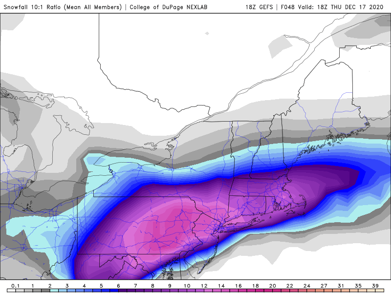
![]() by jmanley32 Tue Dec 15, 2020 5:21 pm
by jmanley32 Tue Dec 15, 2020 5:21 pm
this is very nice and makes me happy. The heavy bands right north of center crush my area. May be some sleet but brief. Winds are go b cranking so b a lot huge drifts if we see upper end over 12. Which my warning caps it at 16.Frank_Wx wrote:Definitely a south/colder trend on 18z runs so far.
I am concerned about this dry slot showing up. Because of how much frontogenesis sets up in central PA into NY, and the surface low is WAY SE of there (off the NJ coast), there is going to be an area of subsidence, or sinking air, in between the 'mega' band and the low itself. That would be somewhere between eastern PA and WNJ. Now, if the CBB band trends S-SE, it likely means we're seeing better tracking of the mid-level lows and it would eliminate the risk of a dry slot completely.
You can see it on the GFS, but regardless, it was still a good run!
jmanley32- Senior Enthusiast
- Posts : 20535
Reputation : 108
Join date : 2013-12-12
Age : 43
Location : Yonkers, NY
Re: 12/16 to 12/17 Godzilla - 1st Call Snow Map
![]() by amugs Tue Dec 15, 2020 5:23 pm
by amugs Tue Dec 15, 2020 5:23 pm
The LP placement has again been within normal wobbles. The OP has been up down and all around, like so many weenies.
Again the cold is dense and a 1039 HP is mint. What till the snowpack sets in and the low temps turn tnis into a block of ice when we are in the teens to single digits. Thats for after the storm.
Last edited by amugs on Tue Dec 15, 2020 5:31 pm; edited 1 time in total
_________________
Mugs
AKA:King: Snow Weenie
Self Proclaimed
WINTER 2014-15 : 55.12" +.02 for 6 coatings (avg. 35")
WINTER 2015-16 Total - 29.8" (Avg 35")
WINTER 2016-17 : 39.5" so far
amugs- Advanced Forecaster - Mod
- Posts : 15095
Reputation : 213
Join date : 2013-01-07
Age : 54
Location : Hillsdale,NJ
Re: 12/16 to 12/17 Godzilla - 1st Call Snow Map
![]() by jmanley32 Tue Dec 15, 2020 5:28 pm
by jmanley32 Tue Dec 15, 2020 5:28 pm
yeah not look forward to that that's how I broke my bumper on my last car. Need get a trowel or metal postamugs wrote:The GEFS have not 2averes from 6 or 12 Z. Its mean has been basically the same with an inch of two each time across the area for snow.
The LP placement has again been within normal wobbles. The OP has been up down and all around, like so many weenies.
Again the cold is dense and a 1039 HP is mint. What till the snowpack sets in and the low temps turn tnis into a block of ice when we are in the teens to single digits. Thats for after the storm.
jmanley32- Senior Enthusiast
- Posts : 20535
Reputation : 108
Join date : 2013-12-12
Age : 43
Location : Yonkers, NY
RJB8525 likes this post
Re: 12/16 to 12/17 Godzilla - 1st Call Snow Map
![]() by amugs Tue Dec 15, 2020 5:39 pm
by amugs Tue Dec 15, 2020 5:39 pm


_________________
Mugs
AKA:King: Snow Weenie
Self Proclaimed
WINTER 2014-15 : 55.12" +.02 for 6 coatings (avg. 35")
WINTER 2015-16 Total - 29.8" (Avg 35")
WINTER 2016-17 : 39.5" so far
amugs- Advanced Forecaster - Mod
- Posts : 15095
Reputation : 213
Join date : 2013-01-07
Age : 54
Location : Hillsdale,NJ
Page 10 of 12 • 1, 2, 3 ... 9, 10, 11, 12 ![]()