Long Range Discussions 21.0
+33
jimv45
oldtimer
hyde345
sabamfa
SENJsnowman
essexcountypete
SNOW MAN
algae888
docstox12
mmanisca
skinsfan1177
rb924119
mwilli
weatherwatchermom
CPcantmeasuresnow
dkodgis
TheAresian
Snow88
Zhukov1945
Mike1984
dsix85
sroc4
lglickman1
WeatherBob
heehaw453
Irish
phil155
billg315
jmanley32
aiannone
frank 638
amugs
Frank_Wx
37 posters
Page 12 of 15
Page 12 of 15 •  1 ... 7 ... 11, 12, 13, 14, 15
 Re: Long Range Discussions 21.0
I think Next Friday/Saturday 2/26-2/27 needs to be monitored too. Models aren't screaming anything but there is going to be a baroclinic zone near by. It won't take much for a wave to ride it and produce something. Are we on the good side of the zone and is there a strong enough wave?
heehaw453- Advanced Forecaster

- Posts : 3906
Join date : 2014-01-20
 Re: Long Range Discussions 21.0
Looking at the long range, looks like spring is right around the corner. Even if things line up just right and we get lucky with a storm, it won't hang around long.
Correct me if I'm wrong.
Correct me if I'm wrong.
Irish- Pro Enthusiast

- Posts : 788
Join date : 2019-01-16
 Re: Long Range Discussions 21.0
heehaw453 wrote:I think Next Friday/Saturday 2/26-2/27 needs to be monitored too. Models aren't screaming anything but there is going to be a baroclinic zone near by. It won't take much for a wave to ride it and produce something. Are we on the good side of the zone and is there a strong enough wave?
Looks too warm, no?
Last edited by Irish on Sun Feb 21, 2021 12:57 pm; edited 1 time in total

Irish- Pro Enthusiast

- Posts : 788
Reputation : 19
Join date : 2019-01-16
Age : 45
Location : Old Bridge, NJ
 Re: Long Range Discussions 21.0
Irish wrote:Looking at the long range, looks like spring is right around the corner. Even if things line up just right and we get lucky with a storm, it won't hang around long.
Correct me if I'm wrong.
Who knows? People were looking at long range in early January and saying winter was over and we all got close to 30 inches in Feb and I'm expecting another 2-3 tomorrow. I don't look at anything past 7-10 days and there are too many variables, especially in March.

hyde345- Pro Enthusiast

- Posts : 1082
Reputation : 48
Join date : 2013-01-08
Location : Hyde Park, NY
Grselig and Irish like this post

hyde345- Pro Enthusiast

- Posts : 1082
Reputation : 48
Join date : 2013-01-08
Location : Hyde Park, NY
 Re: Long Range Discussions 21.0
Irish wrote:heehaw453 wrote:I think Next Friday/Saturday 2/26-2/27 needs to be monitored too. Models aren't screaming anything but there is going to be a baroclinic zone near by. It won't take much for a wave to ride it and produce something. Are we on the good side of the zone and is there a strong enough wave?
Looks too warm, no?
The bigger risk for Friday/Sat is not too warm, it's the question of whether or not the storm will form and climb high enough latitude for moisture to reach our area. Calling an early spring right now is just too premature IMO regardless of what long range models may show. We've had a severe -AO and they tend to not just close shop up so easily and they also tend to come in clusters (span a few years). We shall see.
heehaw453- Advanced Forecaster

- Posts : 3906
Reputation : 86
Join date : 2014-01-20
Location : Bedminster Township, PA Elevation 600' ASL
weatherwatchermom likes this post
 Re: Long Range Discussions 21.0
heehaw453 wrote:Irish wrote:heehaw453 wrote:I think Next Friday/Saturday 2/26-2/27 needs to be monitored too. Models aren't screaming anything but there is going to be a baroclinic zone near by. It won't take much for a wave to ride it and produce something. Are we on the good side of the zone and is there a strong enough wave?
Looks too warm, no?
The bigger risk for Friday/Sat is not too warm, it's the question of whether or not the storm will form and climb high enough latitude for moisture to reach our area. Calling an early spring right now is just too premature IMO regardless of what long range models may show. We've had a severe -AO and they tend to not just close shop up so easily and they also tend to come in clusters (span a few years). We shall see.
Right, I was just saying the more we push forward into March and the angle of the sun changes, the more likely it will be that even if we get the variables lined up for a storm, we likely won't have long stretches of cold to keep it around.

Irish- Pro Enthusiast

- Posts : 788
Reputation : 19
Join date : 2019-01-16
Age : 45
Location : Old Bridge, NJ
 Re: Long Range Discussions 21.0
Irish wrote:heehaw453 wrote:Irish wrote:heehaw453 wrote:I think Next Friday/Saturday 2/26-2/27 needs to be monitored too. Models aren't screaming anything but there is going to be a baroclinic zone near by. It won't take much for a wave to ride it and produce something. Are we on the good side of the zone and is there a strong enough wave?
Looks too warm, no?
The bigger risk for Friday/Sat is not too warm, it's the question of whether or not the storm will form and climb high enough latitude for moisture to reach our area. Calling an early spring right now is just too premature IMO regardless of what long range models may show. We've had a severe -AO and they tend to not just close shop up so easily and they also tend to come in clusters (span a few years). We shall see.
Right, I was just saying the more we push forward into March and the angle of the sun changes, the more likely it will be that even if we get the variables lined up for a storm, we likely won't have long stretches of cold to keep it around.
True you need a deep cold arctic air mass during the day ala 2015 BUT if it comes during darkness then it won't matter.
GFS has massive 980's cutter for March 2 and Euro has a Southern Storm climbing the coast - March Madness has begun. Do not be sold on any one model output as the shortwaves are shortening and it gives the models fits with these perturbations. The cold and very cold air that is still at play and the warm tropical air is starting its migration North. A deep storm can pull this cold air down or warm air up.
Spring will rear itself as things move forward since we are 27 days away, sun angle increasing as is it intensity. Severe weather should be very interesting with this meridional jet structure we have in place and its not going away anytime soon.
_________________
Mugs
AKA:King: Snow Weenie
Self Proclaimed
WINTER 2014-15 : 55.12" +.02 for 6 coatings (avg. 35")
WINTER 2015-16 Total - 29.8" (Avg 35")
WINTER 2016-17 : 39.5" so far

amugs- Advanced Forecaster - Mod

- Posts : 15095
Reputation : 213
Join date : 2013-01-07
Age : 54
Location : Hillsdale,NJ
dolphins222, weatherwatchermom, SENJsnowman and Irish like this post
 Re: Long Range Discussions 21.0
Irish wrote:heehaw453 wrote:Irish wrote:heehaw453 wrote:I think Next Friday/Saturday 2/26-2/27 needs to be monitored too. Models aren't screaming anything but there is going to be a baroclinic zone near by. It won't take much for a wave to ride it and produce something. Are we on the good side of the zone and is there a strong enough wave?
Looks too warm, no?
The bigger risk for Friday/Sat is not too warm, it's the question of whether or not the storm will form and climb high enough latitude for moisture to reach our area. Calling an early spring right now is just too premature IMO regardless of what long range models may show. We've had a severe -AO and they tend to not just close shop up so easily and they also tend to come in clusters (span a few years). We shall see.
Right, I was just saying the more we push forward into March and the angle of the sun changes, the more likely it will be that even if we get the variables lined up for a storm, we likely won't have long stretches of cold to keep it around.
Absolutely, the March sun will eat snow on the ground like a vacuum. March is all about an intense storm that dumps a lot of snow and then the melting starts immediately. There's no doubt that any snow exposed to the sun will be gone in short order. Even if it's cold the sun does a number of the snow.
heehaw453- Advanced Forecaster

- Posts : 3906
Reputation : 86
Join date : 2014-01-20
Location : Bedminster Township, PA Elevation 600' ASL
 Re: Long Range Discussions 21.0
Mugs. What’s happening for tomorrow. Any white gold getting to te coast?
oldtimer- Senior Enthusiast

- Posts : 1103
Reputation : 14
Join date : 2013-01-16
Age : 78
Location : Port Jefferson Station Suffolk County
heehaw453- Advanced Forecaster

- Posts : 3906
Reputation : 86
Join date : 2014-01-20
Location : Bedminster Township, PA Elevation 600' ASL
 Re: Long Range Discussions 21.0
_________________
Mugs
AKA:King: Snow Weenie
Self Proclaimed
WINTER 2014-15 : 55.12" +.02 for 6 coatings (avg. 35")
WINTER 2015-16 Total - 29.8" (Avg 35")
WINTER 2016-17 : 39.5" so far

amugs- Advanced Forecaster - Mod

- Posts : 15095
Reputation : 213
Join date : 2013-01-07
Age : 54
Location : Hillsdale,NJ
heehaw453- Advanced Forecaster

- Posts : 3906
Reputation : 86
Join date : 2014-01-20
Location : Bedminster Township, PA Elevation 600' ASL
 Re: Long Range Discussions 21.0
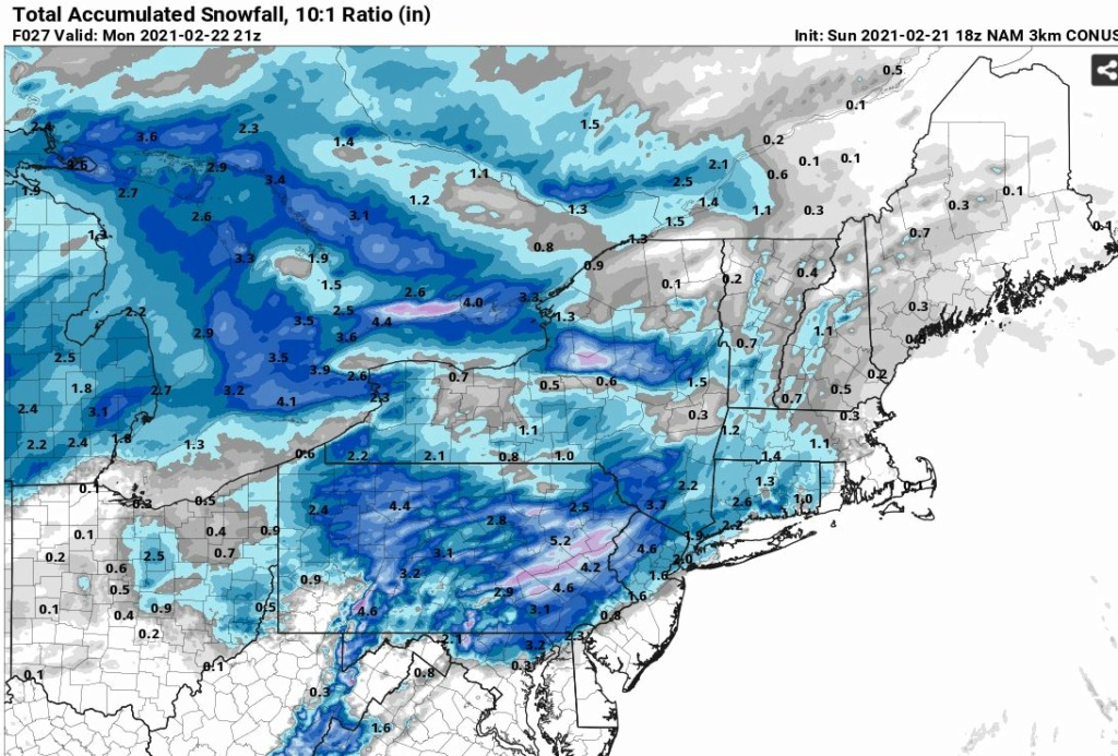
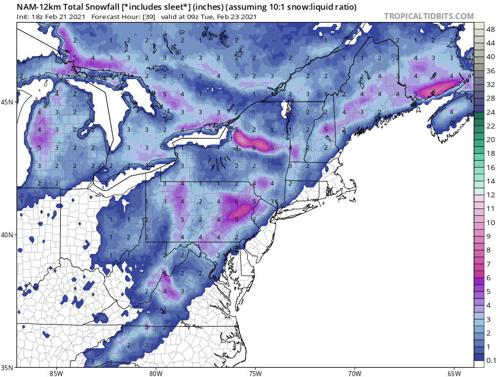
I don't understand NWS Albany calling for only 1/2 inch by me. They say snow for a brief period then rain/snow mix limiting accums. All models show all or mostly snow with 2-3 inches by me north of 84.

hyde345- Pro Enthusiast

- Posts : 1082
Reputation : 48
Join date : 2013-01-08
Location : Hyde Park, NY
 Re: Long Range Discussions 21.0
hyde345 wrote:I don't understand NWS Albany calling for only 1/2 inch by me. They say snow for a brief period then rain/snow mix limiting accums. All models show all or mostly snow with 2-3 inches by me north of 84.
Either way, does it really matter? It's basically a non-event. Set your eyes to the future kind gent.

Irish- Pro Enthusiast

- Posts : 788
Reputation : 19
Join date : 2019-01-16
Age : 45
Location : Old Bridge, NJ
 Re: Long Range Discussions 21.0
Irish wrote:hyde345 wrote:I don't understand NWS Albany calling for only 1/2 inch by me. They say snow for a brief period then rain/snow mix limiting accums. All models show all or mostly snow with 2-3 inches by me north of 84.
Either way, does it really matter? It's basically a non-event. Set your eyes to the future kind gent.
I was expecting a 2-3 inch type event in a 3-4 hour period with some good snow rates which I still think is possible. That's not a non event. A 1/2 inch with mixed snow/rain is just blah.

hyde345- Pro Enthusiast

- Posts : 1082
Reputation : 48
Join date : 2013-01-08
Location : Hyde Park, NY
 Re: Long Range Discussions 21.0
There is a thread for ythis event but I just wanted to say I completely agree with you. They can't all be 6+ inch snowfalls, i forget what year it was but in late Feb/March we had like 4-5 events 6 and under and it added like 20-25 inches to my total. And you are good spot I dunno with NWS, I was expecting rain but now some SR models show a few inches into my area albeit on the very edge of that or rain.hyde345 wrote:Irish wrote:hyde345 wrote:I don't understand NWS Albany calling for only 1/2 inch by me. They say snow for a brief period then rain/snow mix limiting accums. All models show all or mostly snow with 2-3 inches by me north of 84.
Either way, does it really matter? It's basically a non-event. Set your eyes to the future kind gent.
I was expecting a 2-3 inch type event in a 3-4 hour period with some good snow rates which I still think is possible. That's not a non event. A 1/2 inch with mixed snow/rain is just blah.

jmanley32- Senior Enthusiast

- Posts : 20535
Reputation : 108
Join date : 2013-12-12
Age : 43
Location : Yonkers, NY
 Re: Long Range Discussions 21.0
Yep hyde ALbany just woke up 2-5 they are saying now. And it might be an non-event in his backyard but it called a minor event from some on this board.
jimv45- Senior Enthusiast

- Posts : 1168
Reputation : 36
Join date : 2013-09-20
Location : Hopewell jct.
 Re: Long Range Discussions 21.0
jimv45 wrote:Yep hyde ALbany just woke up 2-5 they are saying now. And it might be an non-event in his backyard but it called a minor event from some on this board.
Albany is sometimes asleep at the switch with their evening forecasts. I've seen it before and I don't understand why. It was obvious we were going to see a short duration but potentially impactful event only because it will come down pretty hard for say 2-4 hours. That can cause problems. The fact that they were calling for 1/2 inch with mix rain/snow makes me SMH when ALL guidance has us as snow except for a brief time at the beginning before the intensity increases and the column cools.

hyde345- Pro Enthusiast

- Posts : 1082
Reputation : 48
Join date : 2013-01-08
Location : Hyde Park, NY
 Re: Long Range Discussions 21.0
Irish wrote:hyde345 wrote:I don't understand NWS Albany calling for only 1/2 inch by me. They say snow for a brief period then rain/snow mix limiting accums. All models show all or mostly snow with 2-3 inches by me north of 84.
Either way, does it really matter? It's basically a non-event. Set your eyes to the future kind gent.
It's a fairly large forum, encompassing about a 75 mile radius from NYC in all directions with active posters in all those areas, that's a lot of vastly different winters. Someone living 50-75 miles NW, N or NE of NYC vs someone living 50-75 miles south of NYC have very different winters and different winter expectations. Within that area you have places that average more than 60 inches of snow per season and on the south jersey shore they average less than 20 inches per season.
One mans non event, rain, slop or an inch or less, is often times another man or womans, 3-5 inch, or more in the case of many storms, winter wonderland. This appears to be one of those storms. As we head into March they will be more often the case than not.

CPcantmeasuresnow- Wx Statistician Guru

- Posts : 7274
Reputation : 230
Join date : 2013-01-07
Age : 103
Location : Eastern Orange County, NY
GreyBeard likes this post
 Re: Long Range Discussions 21.0
Yes I have learned finally lol that this is just the climate I chose to live in and I have to suck it up , good luck getting your 3-5 maybe you even get 6 who knows some pretty crazy rates with this, it also looks like a severe t-storm line to the south, might some see thunder snow I wonder.CPcantmeasuresnow wrote:Irish wrote:hyde345 wrote:I don't understand NWS Albany calling for only 1/2 inch by me. They say snow for a brief period then rain/snow mix limiting accums. All models show all or mostly snow with 2-3 inches by me north of 84.
Either way, does it really matter? It's basically a non-event. Set your eyes to the future kind gent.
It's a fairly large forum, encompassing about a 75 mile radius from NYC in all directions with active posters in all those areas, that's a lot of vastly different winters. Someone living 50-75 miles NW, N or NE of NYC vs someone living 50-75 miles south of NYC have very different winters and different winter expectations. Within that area you have places that average more than 60 inches of snow per season and on the south jersey shore they average less than 20 inches per season.
One mans non event, rain, slop or an inch or less, is often times another man or womans, 3-5 inch, or more in the case of many storms, winter wonderland. This appears to be one of those storms. As we head into March they will be more often the case than not.

jmanley32- Senior Enthusiast

- Posts : 20535
Reputation : 108
Join date : 2013-12-12
Age : 43
Location : Yonkers, NY
 Re: Long Range Discussions 21.0
jmanley32 wrote:Yes I have learned finally lol that this is just the climate I chose to live in and I have to suck it up , good luck getting your 3-5 maybe you even get 6 who knows some pretty crazy rates with this, it also looks like a severe t-storm line to the south, might some see thunder snow I wonder.CPcantmeasuresnow wrote:Irish wrote:hyde345 wrote:I don't understand NWS Albany calling for only 1/2 inch by me. They say snow for a brief period then rain/snow mix limiting accums. All models show all or mostly snow with 2-3 inches by me north of 84.
Either way, does it really matter? It's basically a non-event. Set your eyes to the future kind gent.
It's a fairly large forum, encompassing about a 75 mile radius from NYC in all directions with active posters in all those areas, that's a lot of vastly different winters. Someone living 50-75 miles NW, N or NE of NYC vs someone living 50-75 miles south of NYC have very different winters and different winter expectations. Within that area you have places that average more than 60 inches of snow per season and on the south jersey shore they average less than 20 inches per season.
One mans non event, rain, slop or an inch or less, is often times another man or womans, 3-5 inch, or more in the case of many storms, winter wonderland. This appears to be one of those storms. As we head into March they will be more often the case than not.
I wouldn't count yourself out on this yet for at least an inch or two. It's so close it will be a nowcast in and around NYC.

CPcantmeasuresnow- Wx Statistician Guru

- Posts : 7274
Reputation : 230
Join date : 2013-01-07
Age : 103
Location : Eastern Orange County, NY
 Re: Long Range Discussions 21.0
A turn of the page and what have we tomorrow? Around here, maybe an inch more of snow in the late morning. What about February 27 or March 1? What is brewing? Yes I know it is a ways out and models showing things now mean very little out that far...but a man can dream. I am going for the cherry on top here, people.

dkodgis- Senior Enthusiast

- Posts : 2560
Reputation : 98
Join date : 2013-12-29
CPcantmeasuresnow likes this post
 Re: Long Range Discussions 21.0
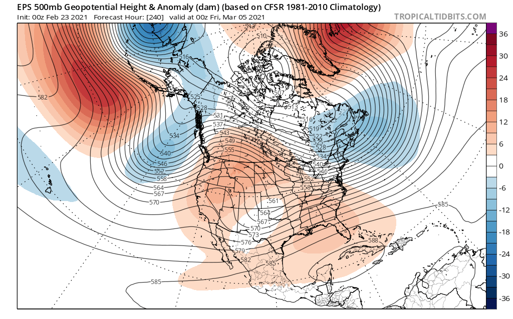
EPS is no longer showing a sustained warm pattern as we get into March, but instead it portrays a blocking pattern returning. With the way this winter has successfully fought off a LaNina setup thus far and the fact that the last few Marches have been productive, I think old man winter has at least one last punch to throw at us.

nutleyblizzard- Senior Enthusiast

- Posts : 1954
Reputation : 41
Join date : 2014-01-30
Age : 58
Location : Nutley, new jersey
amugs, CPcantmeasuresnow, SNOW MAN, weatherwatchermom and Irish like this post
 Re: Long Range Discussions 21.0
Piggybacking Nutley post - looks to be resetting the table for possible wintry threats 1 week into the maybe ethsecond week of March

Damien for you and teh N&W crew
Saturday morning nice thump


Damien for you and teh N&W crew
Saturday morning nice thump

_________________
Mugs
AKA:King: Snow Weenie
Self Proclaimed
WINTER 2014-15 : 55.12" +.02 for 6 coatings (avg. 35")
WINTER 2015-16 Total - 29.8" (Avg 35")
WINTER 2016-17 : 39.5" so far

amugs- Advanced Forecaster - Mod

- Posts : 15095
Reputation : 213
Join date : 2013-01-07
Age : 54
Location : Hillsdale,NJ
CPcantmeasuresnow likes this post
 Re: Long Range Discussions 21.0
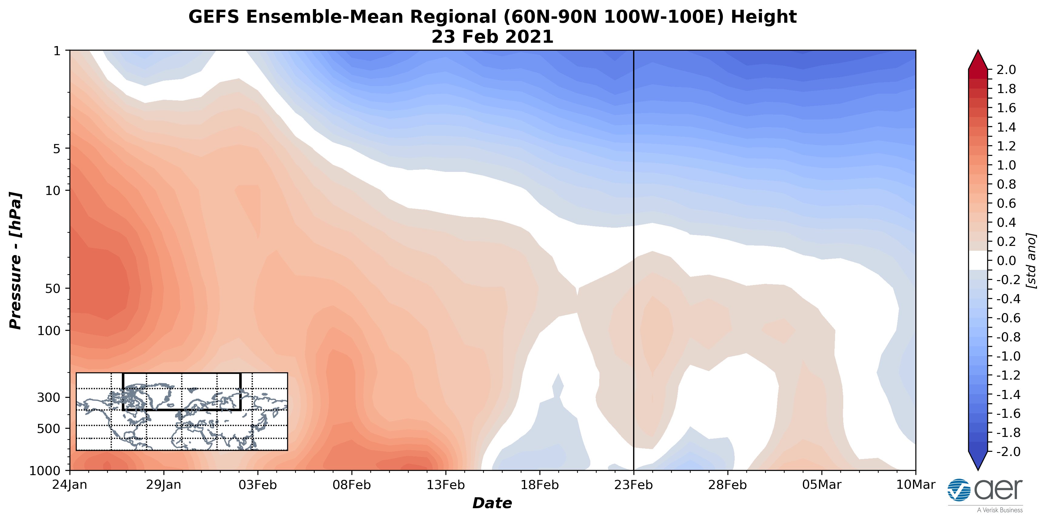
PV Disturbance that equate sto what we are seeing next week so far, the orangy colors the propagate down to the surface are what is important on this chart

_________________
Mugs
AKA:King: Snow Weenie
Self Proclaimed
WINTER 2014-15 : 55.12" +.02 for 6 coatings (avg. 35")
WINTER 2015-16 Total - 29.8" (Avg 35")
WINTER 2016-17 : 39.5" so far

amugs- Advanced Forecaster - Mod

- Posts : 15095
Reputation : 213
Join date : 2013-01-07
Age : 54
Location : Hillsdale,NJ
 Re: Long Range Discussions 21.0
Sping is coming, models showing lots of rain, well at least down here, personally I am good, its all snirt and I got a ticket today for alternate side parking in which they did NOTHING but give tickets to EVRYONE. Never have they done alternate side when there is snow OTG.

jmanley32- Senior Enthusiast

- Posts : 20535
Reputation : 108
Join date : 2013-12-12
Age : 43
Location : Yonkers, NY
Page 12 of 15 •  1 ... 7 ... 11, 12, 13, 14, 15
Page 12 of 15
Permissions in this forum:
You cannot reply to topics in this forum|
|
|

 Home
Home
