
 Search
Long Range Discussions 21.0
Page 3 of 15 •  1, 2, 3, 4 ... 9 ... 15
 ![]()
Re: Long Range Discussions 21.0
![]() by Irish Tue Feb 02, 2021 6:51 am
by Irish Tue Feb 02, 2021 6:51 am
Irish- Pro Enthusiast

- Posts : 788
Join date : 2019-01-16
Re: Long Range Discussions 21.0
![]() by jmanley32 Tue Feb 02, 2021 6:54 am
by jmanley32 Tue Feb 02, 2021 6:54 am
TWC has me for 2-6 on Sunday not that thats at all accurate. Where did you see it saying another major storm? I know the models show it but I do not see the story. I am not go complain at all about a mothrazilla after this storm we kinda need a bit of a break, or I do anyways to allow for some cleanup.frank 638 wrote:Twc has another major storm for this Sunday into Monday and then another when next week
jmanley32- Senior Enthusiast

- Posts : 20535
Join date : 2013-12-12
Re: Long Range Discussions 21.0
![]() by heehaw453 Tue Feb 02, 2021 7:48 am
by heehaw453 Tue Feb 02, 2021 7:48 am
heehaw453- Advanced Forecaster

- Posts : 3906
Reputation : 86
Join date : 2014-01-20
Location : Bedminster Township, PA Elevation 600' ASL
Re: Long Range Discussions 21.0
![]() by billg315 Tue Feb 02, 2021 8:16 am
by billg315 Tue Feb 02, 2021 8:16 am

billg315- Advanced Forecaster - Mod

- Posts : 4483
Reputation : 185
Join date : 2015-01-24
Age : 50
Location : Flemington, NJ
Re: Long Range Discussions 21.0
![]() by amugs Tue Feb 02, 2021 8:33 am
by amugs Tue Feb 02, 2021 8:33 am
_________________
Mugs
AKA:King: Snow Weenie
Self Proclaimed
WINTER 2014-15 : 55.12" +.02 for 6 coatings (avg. 35")
WINTER 2015-16 Total - 29.8" (Avg 35")
WINTER 2016-17 : 39.5" so far

amugs- Advanced Forecaster - Mod
- Posts : 15095
Reputation : 213
Join date : 2013-01-07
Age : 54
Location : Hillsdale,NJ
Re: Long Range Discussions 21.0
![]() by heehaw453 Tue Feb 02, 2021 8:50 am
by heehaw453 Tue Feb 02, 2021 8:50 am
billg315 wrote:GFS (including 6z this morning) is just missing the hookup between the northern and southern energy. That’s why it’s not developing the storm until too late for us. I’d bet the GFS caves to the Euro on this soon.
GFS 16 has it, but too early of a phase. We need another 2 days I think on this one. Threat windows is there.
heehaw453- Advanced Forecaster
- Posts : 3906
Reputation : 86
Join date : 2014-01-20
Location : Bedminster Township, PA Elevation 600' ASL
Re: Long Range Discussions 21.0
![]() by amugs Tue Feb 02, 2021 9:22 am
by amugs Tue Feb 02, 2021 9:22 am
_________________
Mugs
AKA:King: Snow Weenie
Self Proclaimed
WINTER 2014-15 : 55.12" +.02 for 6 coatings (avg. 35")
WINTER 2015-16 Total - 29.8" (Avg 35")
WINTER 2016-17 : 39.5" so far
amugs- Advanced Forecaster - Mod
- Posts : 15095
Reputation : 213
Join date : 2013-01-07
Age : 54
Location : Hillsdale,NJ
Re: Long Range Discussions 21.0
![]() by Irish Tue Feb 02, 2021 10:24 am
by Irish Tue Feb 02, 2021 10:24 am
amugs wrote:Where does one sign - that is a great signal 5 days out even if its Groundhogs Day!
Putting the contract together as I type...

Irish- Pro Enthusiast
- Posts : 788
Reputation : 19
Join date : 2019-01-16
Age : 45
Location : Old Bridge, NJ
amugs and bloc1357 like this post
Re: Long Range Discussions 21.0
![]() by Frank_Wx Tue Feb 02, 2021 11:13 am
by Frank_Wx Tue Feb 02, 2021 11:13 am
The main difference is the EURO does not sheer the southern energy out, while the GFS does. There is a massive PV over the Hudson Bay which may be why the GFS shears out the southern energy. Let's see what happens today. My GUT tells me a coastal low does develop, but it might be too east. I think the EURO is over-amplifying things a bit
_________________
_______________________________________________________________________________________________________
CLICK HERE to view NJ Strong Snowstorm Classifications

Frank_Wx- Godzilla Seeker

- Posts : 21305
Reputation : 328
Join date : 2013-01-05
Age : 32
Location : Jersey City, NJ -

Re: Long Range Discussions 21.0
![]() by amugs Tue Feb 02, 2021 12:29 pm
by amugs Tue Feb 02, 2021 12:29 pm
The SSW back in January has been trickling down into the troposphere for some time, but this next dip down comes with the lobe of the vortex displaced closer to North America. Subsequently, rather than Siberia, the coldest air will now displace over North America. #Energy #NatGas pic.twitter.com/qp71s37Nc5
— Bret Walts (@BretWaltsWx) February 2, 2021
_________________
Mugs
AKA:King: Snow Weenie
Self Proclaimed
WINTER 2014-15 : 55.12" +.02 for 6 coatings (avg. 35")
WINTER 2015-16 Total - 29.8" (Avg 35")
WINTER 2016-17 : 39.5" so far
amugs- Advanced Forecaster - Mod
- Posts : 15095
Reputation : 213
Join date : 2013-01-07
Age : 54
Location : Hillsdale,NJ
Re: Long Range Discussions 21.0
![]() by WeatherBob Tue Feb 02, 2021 12:40 pm
by WeatherBob Tue Feb 02, 2021 12:40 pm

WeatherBob- Meteorologist

- Posts : 683
Reputation : 83
Join date : 2013-12-13
Location : Caldwell, NJ - NW Essex County - Altitude 500 FT
RJB8525 and sabamfa like this post
Re: Long Range Discussions 21.0
![]() by lglickman1 Tue Feb 02, 2021 12:44 pm
by lglickman1 Tue Feb 02, 2021 12:44 pm
lglickman1- Pro Enthusiast
- Posts : 319
Reputation : 0
Join date : 2013-02-05
Location : New Rochelle, NY
Re: Long Range Discussions 21.0
![]() by phil155 Tue Feb 02, 2021 12:52 pm
by phil155 Tue Feb 02, 2021 12:52 pm
WeatherBob wrote:Farmers almanac predicted for us, Feb 1 to 5, Sunny and mild.
The prognosticator of prognosticators says 6 more weeks of winter
phil155- Pro Enthusiast
- Posts : 483
Reputation : 4
Join date : 2019-12-16
Re: Long Range Discussions 21.0
![]() by heehaw453 Tue Feb 02, 2021 1:27 pm
by heehaw453 Tue Feb 02, 2021 1:27 pm
heehaw453- Advanced Forecaster
- Posts : 3906
Reputation : 86
Join date : 2014-01-20
Location : Bedminster Township, PA Elevation 600' ASL
Re: Long Range Discussions 21.0
![]() by sroc4 Tue Feb 02, 2021 1:36 pm
by sroc4 Tue Feb 02, 2021 1:36 pm
heehaw453 wrote:Euro is consistent on a storm for Sunday. Other guidance is coming more around to the idea too. Interesting.
Euro was a def bombski/bombskiboo/revAlevABomber. Starting tomorrow Im going to start to dive into the details.
_________________
"In weather and in life, there's no winning and losing; there's only winning and learning."
WINTER 2012/2013 TOTALS 43.65"WINTER 2017/2018 TOTALS 62.85" WINTER 2022/2023 TOTALS 4.9"
WINTER 2013/2014 TOTALS 64.85"WINTER 2018/2019 TOTALS 14.25" WINTER 2023/2024 TOTALS 13.1"
WINTER 2014/2015 TOTALS 71.20"WINTER 2019/2020 TOTALS 6.35"
WINTER 2015/2016 TOTALS 35.00"WINTER 2020/2021 TOTALS 37.75"
WINTER 2016/2017 TOTALS 42.25"WINTER 2021/2022 TOTALS 31.65"

sroc4- Admin
- Posts : 8354
Reputation : 302
Join date : 2013-01-07
Location : Wading River, LI
heehaw453 likes this post


aiannone- Senior Enthusiast - Mod
- Posts : 4815
Reputation : 92
Join date : 2013-01-07
Location : Saint James, LI (Northwest Suffolk Co.)
dsix85- Pro Enthusiast
- Posts : 349
Reputation : 8
Join date : 2014-01-01
Location : New York
Re: Long Range Discussions 21.0
![]() by Irish Tue Feb 02, 2021 2:50 pm
by Irish Tue Feb 02, 2021 2:50 pm

Hello SB Sunday if this threading the needle system comes together.
Irish- Pro Enthusiast
- Posts : 788
Reputation : 19
Join date : 2019-01-16
Age : 45
Location : Old Bridge, NJ
Re: Long Range Discussions 21.0
![]() by Irish Tue Feb 02, 2021 2:51 pm
by Irish Tue Feb 02, 2021 2:51 pm

Thank you sir may I have another on 2/10!
Irish- Pro Enthusiast
- Posts : 788
Reputation : 19
Join date : 2019-01-16
Age : 45
Location : Old Bridge, NJ
Re: Long Range Discussions 21.0
![]() by Mike1984 Tue Feb 02, 2021 3:27 pm
by Mike1984 Tue Feb 02, 2021 3:27 pm
Mike1984- Posts : 3
Reputation : 0
Join date : 2020-12-15
Re: Long Range Discussions 21.0
![]() by Irish Tue Feb 02, 2021 3:35 pm
by Irish Tue Feb 02, 2021 3:35 pm
Mike1984 wrote:So what we’re saying here in movie terms is, the previews are on the 5th the sequel comes out the 7th-8th and the trilogy gets released on the 10th?
I'm a weather noob, so pay no attention to me. These are observations I've made and am looking to see what others think.
Irish- Pro Enthusiast
- Posts : 788
Reputation : 19
Join date : 2019-01-16
Age : 45
Location : Old Bridge, NJ
Re: Long Range Discussions 21.0
![]() by amugs Tue Feb 02, 2021 3:50 pm
by amugs Tue Feb 02, 2021 3:50 pm
Mike1984 wrote:So what we’re saying here in movie terms is, the previews are on the 5th the sequel comes out the 7th-8th and the trilogy gets released on the 10th?
Just got in from snow blowing.
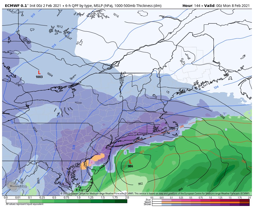
Okay Mike yes it COULD be. We have to pay attention to the interaction between the PV and the Southern Wnergy coming out. GFS shreds the energy like it did last Monday. BIT we have a huge jet streak and anomalous cold air. The clipper Friday set the boundary for tjis storm to run up. So Friday clipper is what we want to pay attention to. If it does it quick job of dump and jump out of here we are in good shape for Sunday. If does a dump and slump then Sunday won't be able to have enough space to gather strength and could slide OTS or just be shredded into nothing. Don't get discouraged if you see it miss after showing a bomb, it's the model shuffle, windshield wiper affect at play. Happens with all storms, except cutters of course.
GFS is notorious for running the LP into a block only get corrected south.
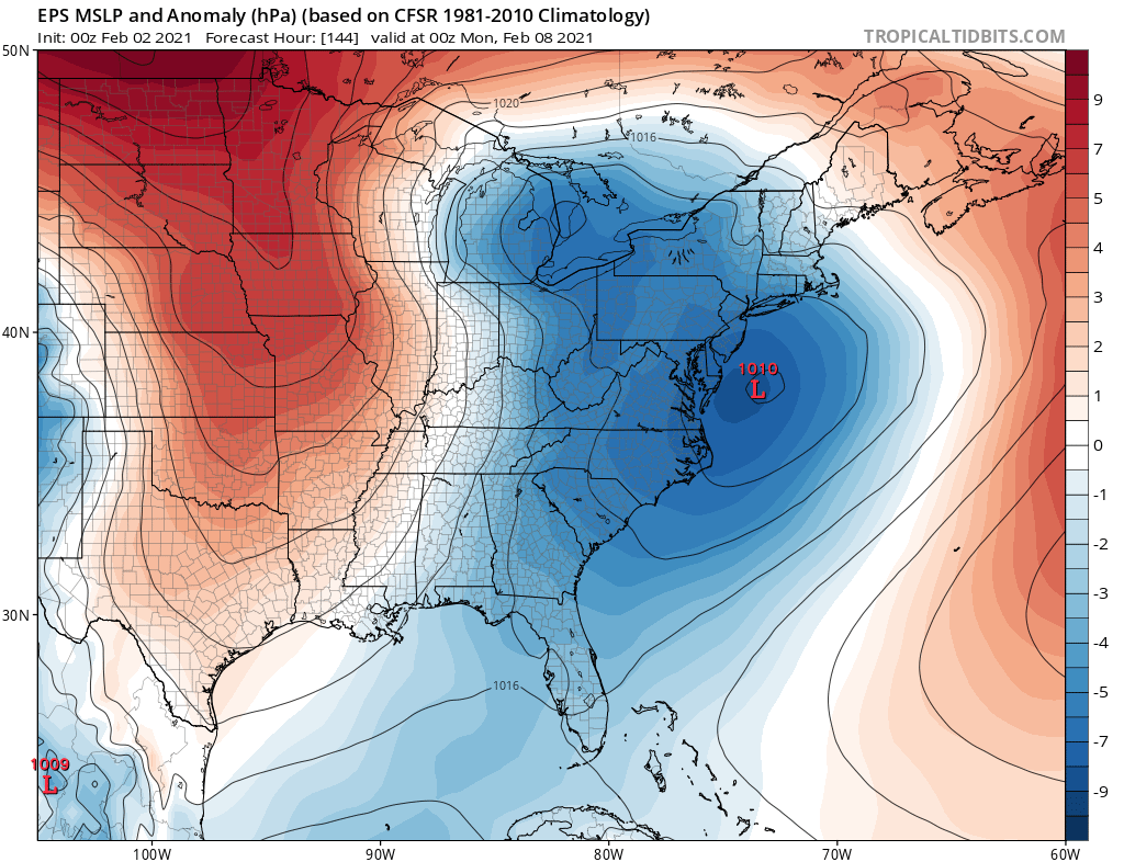
Anyway here is a gif of the EURO run. EPS has a strong signal. Waiting on GEFS to see what they show.

_________________
Mugs
AKA:King: Snow Weenie
Self Proclaimed
WINTER 2014-15 : 55.12" +.02 for 6 coatings (avg. 35")
WINTER 2015-16 Total - 29.8" (Avg 35")
WINTER 2016-17 : 39.5" so far
amugs- Advanced Forecaster - Mod
- Posts : 15095
Reputation : 213
Join date : 2013-01-07
Age : 54
Location : Hillsdale,NJ
Re: Long Range Discussions 21.0
![]() by Zhukov1945 Tue Feb 02, 2021 4:56 pm
by Zhukov1945 Tue Feb 02, 2021 4:56 pm
amugs wrote:Mike1984 wrote:So what we’re saying here in movie terms is, the previews are on the 5th the sequel comes out the 7th-8th and the trilogy gets released on the 10th?
Just got in from snow blowing.
Okay Mike yes it COULD be. We have to pay attention to the interaction between the PV and the Southern Wnergy coming out. GFS shreds the energy like it did last Monday. BIT we have a huge jet streak and anomalous cold air. The clipper Friday set the boundary for tjis storm to run up. So Friday clipper is what we want to pay attention to. If it does it quick job of dump and jump out of here we are in good shape for Sunday. If does a dump and slump then Sunday won't be able to have enough space to gather strength and could slide OTS or just be shredded into nothing. Don't get discouraged if you see it miss after showing a bomb, it's the model shuffle, windshield wiper affect at play. Happens with all storms, except cutters of course.
GFS is notorious for running the LP into a block only get corrected south.
Anyway here is a gif of the EURO run. EPS has a strong signal. Waiting on GEFS to see what they show.
That is one ugly sleet signal for someone depending on how it shakes out. Long way to go in any case.

Zhukov1945- Posts : 138
Reputation : 8
Join date : 2018-03-21
Location : Clinton Township NJ
Re: Long Range Discussions 21.0
![]() by Irish Tue Feb 02, 2021 5:01 pm
by Irish Tue Feb 02, 2021 5:01 pm
Zhukov1945 wrote:amugs wrote:Mike1984 wrote:So what we’re saying here in movie terms is, the previews are on the 5th the sequel comes out the 7th-8th and the trilogy gets released on the 10th?
Just got in from snow blowing.
Okay Mike yes it COULD be. We have to pay attention to the interaction between the PV and the Southern Wnergy coming out. GFS shreds the energy like it did last Monday. BIT we have a huge jet streak and anomalous cold air. The clipper Friday set the boundary for tjis storm to run up. So Friday clipper is what we want to pay attention to. If it does it quick job of dump and jump out of here we are in good shape for Sunday. If does a dump and slump then Sunday won't be able to have enough space to gather strength and could slide OTS or just be shredded into nothing. Don't get discouraged if you see it miss after showing a bomb, it's the model shuffle, windshield wiper affect at play. Happens with all storms, except cutters of course.
GFS is notorious for running the LP into a block only get corrected south.
Anyway here is a gif of the EURO run. EPS has a strong signal. Waiting on GEFS to see what they show.
That is one ugly sleet signal for someone depending on how it shakes out. Long way to go in any case.
That'd be me, right over CNJ.
Irish- Pro Enthusiast
- Posts : 788
Reputation : 19
Join date : 2019-01-16
Age : 45
Location : Old Bridge, NJ
Re: Long Range Discussions 21.0
![]() by Frank_Wx Tue Feb 02, 2021 5:04 pm
by Frank_Wx Tue Feb 02, 2021 5:04 pm
_________________
_______________________________________________________________________________________________________
CLICK HERE to view NJ Strong Snowstorm Classifications
Frank_Wx- Godzilla Seeker
- Posts : 21305
Reputation : 328
Join date : 2013-01-05
Age : 32
Location : Jersey City, NJ -
Re: Long Range Discussions 21.0
![]() by sroc4 Wed Feb 03, 2021 5:49 pm
by sroc4 Wed Feb 03, 2021 5:49 pm
So let it be written, so let it be done
_________________
"In weather and in life, there's no winning and losing; there's only winning and learning."
WINTER 2012/2013 TOTALS 43.65"WINTER 2017/2018 TOTALS 62.85" WINTER 2022/2023 TOTALS 4.9"
WINTER 2013/2014 TOTALS 64.85"WINTER 2018/2019 TOTALS 14.25" WINTER 2023/2024 TOTALS 13.1"
WINTER 2014/2015 TOTALS 71.20"WINTER 2019/2020 TOTALS 6.35"
WINTER 2015/2016 TOTALS 35.00"WINTER 2020/2021 TOTALS 37.75"
WINTER 2016/2017 TOTALS 42.25"WINTER 2021/2022 TOTALS 31.65"
sroc4- Admin
- Posts : 8354
Reputation : 302
Join date : 2013-01-07
Location : Wading River, LI
CPcantmeasuresnow and billg315 like this post
Re: Long Range Discussions 21.0
![]() by Frank_Wx Thu Feb 04, 2021 5:47 pm
by Frank_Wx Thu Feb 04, 2021 5:47 pm
The one near Valentines Day looks very interesting. Has my attention
_________________
_______________________________________________________________________________________________________
CLICK HERE to view NJ Strong Snowstorm Classifications
Frank_Wx- Godzilla Seeker
- Posts : 21305
Reputation : 328
Join date : 2013-01-05
Age : 32
Location : Jersey City, NJ -
Page 3 of 15 • 1, 2, 3, 4 ... 9 ... 15 ![]()
|
|
|