2021 Tropical Season
+35
Lubethan
sabamfa
Radz
clownloach
WeatherBob
dsix85
jimv45
Joe Snow
Scullybutcher
dolphins222
JackShephard
phil155
hyde345
essexcountypete
Nyi1058
nutleyblizzard
Zhukov1945
Grselig
Sanchize06
SoulSingMG
SENJsnowman
Dunnzoo
tomsriversnowstorm
dkodgis
rb924119
Vinnydula
aiannone
New Yorker 234
frank 638
billg315
weatherwatchermom
sroc4
Frank_Wx
jmanley32
amugs
39 posters
Page 5 of 43
Page 5 of 43 •  1, 2, 3, 4, 5, 6 ... 24 ... 43
 Re: 2021 Tropical Season
The GFS might get it done this run. It was close at 06z. I don’t like the look of this…..
rb924119- Meteorologist

- Posts : 6928
Join date : 2013-02-06
 Re: 2021 Tropical Season
sroc4 wrote:rb924119 wrote:Completely tossing the GFS Operational right now because of what it’s doing with the H5 energy associated with TD-8. It completely splits it in half, which makes no sense to me whatsoever.
There has been northerly shear for the past few days pushing the mid level circulation/convection south of the surface center. I see what your talking about. Looking at mid level and upper level shear the strength of the shear seems to want to intensify a little over the next 24-36hrs of so so I think the GFS wanted to completely decouple the mid level moisture from the surface center which is certainly a plausible soln if the mid level shear wins out. That said just looking at satellite imagery this morning it certainly looks like there is healthier convection going off closer to over the top of the LLC, hence why it was upgraded from TD to TS overnight. We shall see how the shear part of the equation plays out over the next day or so.
As far as your idea of it retrograding far enough west to actually tickle excitement centers Im much more pessimistic on this idea. The Eastern Canadian ridging seems to me to be trending centered a tad further west than Id like to see to trigger enough of a westward trend. I feel like there will be too much of a weakness to the ENE and NE with a strong ULL near southern Greenland that will allow the eventual escape. We shall see as it wouldn't take a whole lot of change in the modeling, particularly stronger eastern flank to the ridging in E Canada, to change the course of things. Well see.
FINALLY some discussion!! Haha
Overall, the shear is a non-factor IMO. It’s literally sitting beneath a stacked tropospheric ridge in an area of very light steering flow except for up near the tropopause. Nearly ideal for the next few days. Once the shear finally starts increasing, it will be from the approach of the trough which means it will start encountering the dynamics/forcing for ascent associated with that, thereby limiting the negative impact from the moderate but steady increase in shear. This is why I mentioned a general maintenance of intensity.
Regarding the retrograde, the enhanced/further westward expansion of the ridging is exactly why I’m concerned. It should continue to strengthen on guidance as a result of the Atlantic domain log jam, which would effectively close off access to your weakness.
rb924119- Meteorologist

- Posts : 6928
Join date : 2013-02-06
rb924119- Meteorologist

- Posts : 6928
Reputation : 194
Join date : 2013-02-06
Age : 32
Location : Greentown, Pa
 Re: 2021 Tropical Season
Can you not just post an oh my? We have no clue what it is in reference to. You did not post a visual and most of us don’t have access to them. Can you either post your visual you are saying oh my too or explain. Thank you
tomsriversnowstorm- Posts : 90
Reputation : 0
Join date : 2021-02-06
 Re: 2021 Tropical Season
tomsriversnowstorm wrote:Can you not just post an oh my? We have no clue what it is in reference to. You did not post a visual and most of us don’t have access to them. Can you either post your visual you are saying oh my too or explain. Thank you
Sorry lol
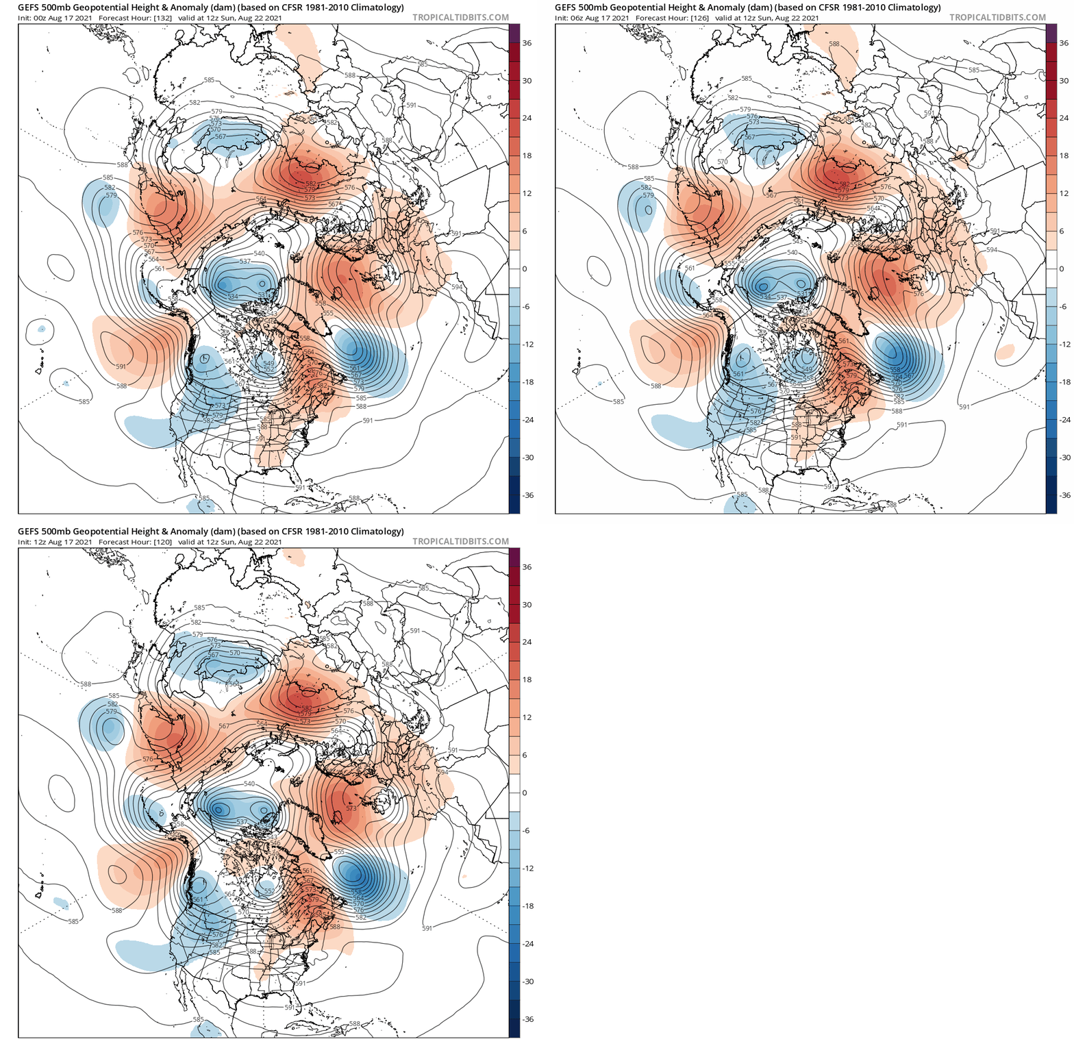
You can see the increasing compression of the pattern in the Atlantic domain as the modeling is finally picking up on the strength of the blocking. As a result, you can see the westward shift of all of the features, as well as an increase in strength in the southern periphery of the Atlantic/eastern North American ridge. Though the reasons for these adjustments are multi-faceted, they are proving to be valid as the modeling continues (and should continue) to adjust further in this direction in my opinion.
rb924119- Meteorologist

- Posts : 6928
Reputation : 194
Join date : 2013-02-06
Age : 32
Location : Greentown, Pa
 Re: 2021 Tropical Season
Perfect makes much more sense now. Thank you very much
tomsriversnowstorm- Posts : 90
Reputation : 0
Join date : 2021-02-06
rb924119 likes this post
 Re: 2021 Tropical Season
We may need to have a meet-up down the shore for this one! I'm down here until the 27th... should be fun, or not lol
_________________
Janet
Snowfall winter of 2023-2024 17.5"
Snowfall winter of 2022-2023 6.0"
Snowfall winter of 2021-2022 17.6" 1" sleet 2/25/22
Snowfall winter of 2020-2021 51.1"
Snowfall winter of 2019-2020 8.5"
Snowfall winter of 2018-2019 25.1"
Snowfall winter of 2017-2018 51.9"
Snowfall winter of 2016-2017 45.6"
Snowfall winter of 2015-2016 29.5"
Snowfall winter of 2014-2015 50.55"
Snowfall winter of 2013-2014 66.5"
Dunnzoo- Senior Enthusiast - Mod

- Posts : 4904
Reputation : 68
Join date : 2013-01-11
Age : 62
Location : Westwood, NJ
rb924119- Meteorologist

- Posts : 6928
Reputation : 194
Join date : 2013-02-06
Age : 32
Location : Greentown, Pa
 Re: 2021 Tropical Season
Dunnzoo wrote:We may need to have a meet-up down the shore for this one! I'm down here until the 27th... should be fun, or not lol
I’d love to do a meet up, but not when a tropical entity is threatening aha
rb924119- Meteorologist

- Posts : 6928
Reputation : 194
Join date : 2013-02-06
Age : 32
Location : Greentown, Pa
 Re: 2021 Tropical Season
rb924119 wrote:sroc4 wrote:rb924119 wrote:Completely tossing the GFS Operational right now because of what it’s doing with the H5 energy associated with TD-8. It completely splits it in half, which makes no sense to me whatsoever.
There has been northerly shear for the past few days pushing the mid level circulation/convection south of the surface center. I see what your talking about. Looking at mid level and upper level shear the strength of the shear seems to want to intensify a little over the next 24-36hrs of so so I think the GFS wanted to completely decouple the mid level moisture from the surface center which is certainly a plausible soln if the mid level shear wins out. That said just looking at satellite imagery this morning it certainly looks like there is healthier convection going off closer to over the top of the LLC, hence why it was upgraded from TD to TS overnight. We shall see how the shear part of the equation plays out over the next day or so.
As far as your idea of it retrograding far enough west to actually tickle excitement centers Im much more pessimistic on this idea. The Eastern Canadian ridging seems to me to be trending centered a tad further west than Id like to see to trigger enough of a westward trend. I feel like there will be too much of a weakness to the ENE and NE with a strong ULL near southern Greenland that will allow the eventual escape. We shall see as it wouldn't take a whole lot of change in the modeling, particularly stronger eastern flank to the ridging in E Canada, to change the course of things. Well see.
FINALLY some discussion!! Haha
Overall, the shear is a non-factor IMO. It’s literally sitting beneath a stacked tropospheric ridge in an area of very light steering flow except for up near the tropopause. Nearly ideal for the next few days. Once the shear finally starts increasing, it will be from the approach of the trough which means it will start encountering the dynamics/forcing for ascent associated with that, thereby limiting the negative impact from the moderate but steady increase in shear. This is why I mentioned a general maintenance of intensity.
Regarding the retrograde, the enhanced/further westward expansion of the ridging is exactly why I’m concerned. It should continue to strengthen on guidance as a result of the Atlantic domain log jam, which would effectively close off access to your weakness.
You're not kidding brother. The weather has been so boing. I will respectfully disagree on the shear being a non factor, although thus far Henri has def over performed relative to modeling a few days ago. The relatively weak shear out of the north had kept the convection south of center, however, the shear has been minimal for the past 2-3days, so I believe thats why it was able to develop and "overachieve". As you can see currently its sitting in a pretty low shear environment:

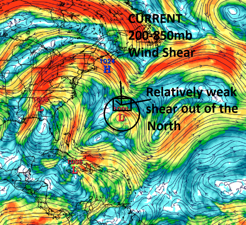
But in about 24 hrs from now the shear to the north rounds the risge and digs south towards Henri looking like this.
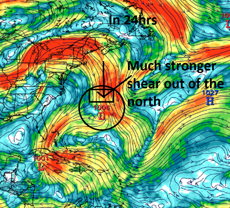
By 48hr if you look at the relative humidity chart you can clearly see the convection and therefore mid level circulation is well south of the system yet again. LLC Black circle, Yellow circle Mid level Cente, and blue circle is the moisture field
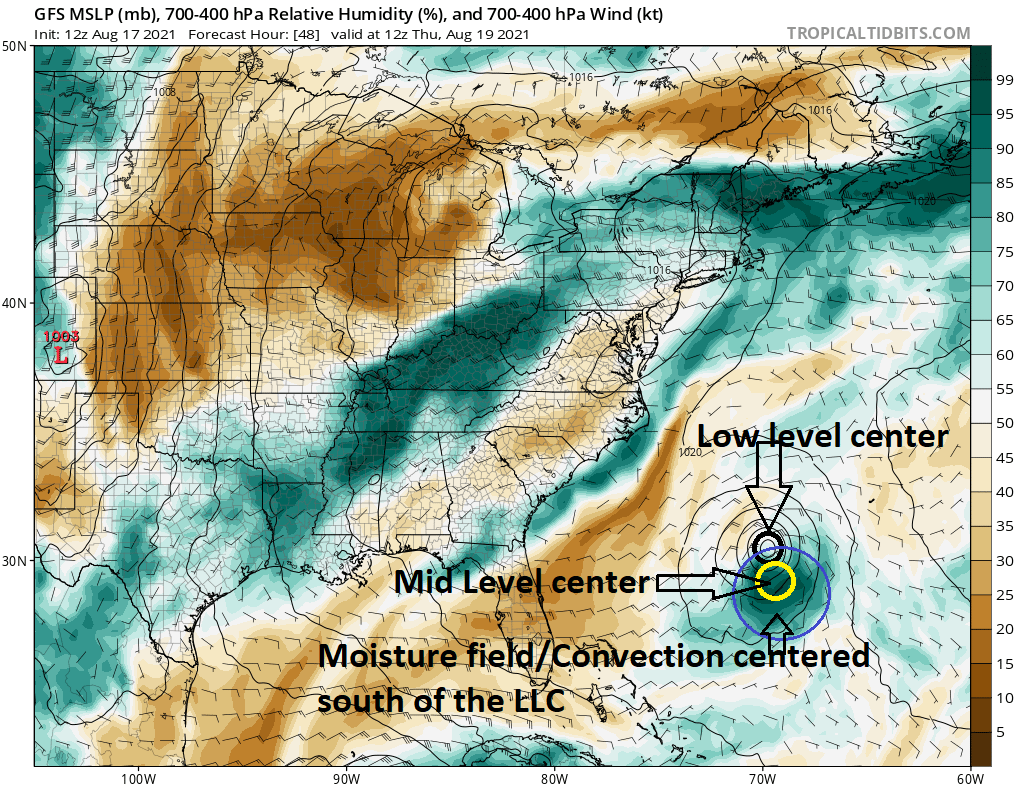
For those who arent following if you were to visualize the image above looking at it from a side view, say fom the ground what you would be visualizing is a tilted vortexx. If you were standing in Florida looking east, the vortex would look tilted from left to right with altitude or height.
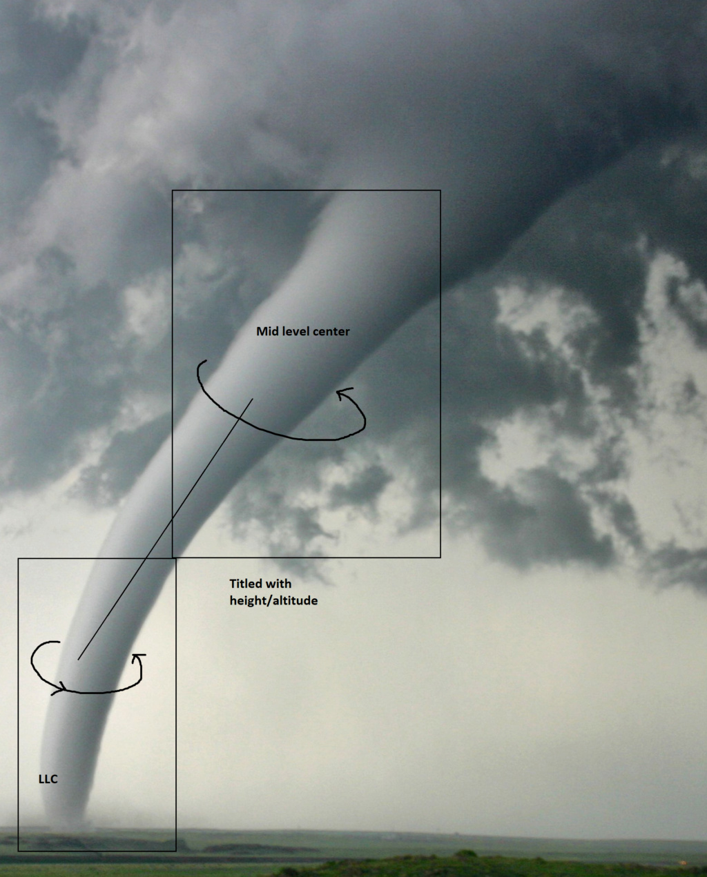
Ray this tilted vortex will likely cause Henri to weaken from its current intensity. I think by this time tomorrow we are seeing him weaken some.
Tropical Storm HENRI
As of 18:00 UTC Aug 17, 2021:
Location: 30.4°N 64.2°W
Maximum Winds: 50 kt Gusts: N/A
Minimum Central Pressure: 1000 mb
Environmental Pressure: N/A
Radius of Circulation: N/A
Radius of Maximum wind: 25 nm
50 kt Wind Radii by Quadrant:
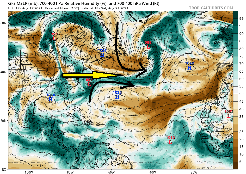
GFS has been adamant about the shear and Euro has a much weaker system overall relative to the GFS. Its shear forecast insists on at least 25-35kts of shear over the next two days. With this thing moving so slowly two days will be an eternity and alot can and likely will change. How far S&W will it go, such that we then see how the mean pattern to the north will influence him.
There is still a huge weakness out there for the escape. I hear what your saying but Im not sold on it yet.
_________________
"In weather and in life, there's no winning and losing; there's only winning and learning."
WINTER 2012/2013 TOTALS 43.65"WINTER 2017/2018 TOTALS 62.85" WINTER 2022/2023 TOTALS 4.9"
WINTER 2013/2014 TOTALS 64.85"WINTER 2018/2019 TOTALS 14.25" WINTER 2023/2024 TOTALS 13.1"
WINTER 2014/2015 TOTALS 71.20"WINTER 2019/2020 TOTALS 6.35"
WINTER 2015/2016 TOTALS 35.00"WINTER 2020/2021 TOTALS 37.75"
WINTER 2016/2017 TOTALS 42.25"WINTER 2021/2022 TOTALS 31.65"

sroc4- Admin

- Posts : 8354
Reputation : 302
Join date : 2013-01-07
Location : Wading River, LI
 Re: 2021 Tropical Season
All of that shear is at the very top of column, though; the vast majority of the atmospheric column is pretty much as primed as you’ll ever see it. I’m posting from mobile because I’m getting ready for work, so I can’t post images. But take a look at the winds beneath the 200-300mb level. 5-15knots through about 400-350mb before
you start ramping it up from there. If you have a calm environment where the circulations at all levels can stack, who cares if the cirrus anvils are shearing off when the actual convection is allowed to remain stacked beneath them? In my opinion, that won’t matter. The shear would be disruptive if it was closer to the mid-levels, but it’s not, so the main heat engine should remain in tact.
Once it starts interacting with the trough, THEN it’ll start experiencing shear, but much like we saw with Sandy, the energy and dynamics associated with that interaction should overcome the negative effect of the increased shear, especially since the Atlantic so much warmer than average. At the LEAST, intensity should remain steady-state, in my opinion.
As for your escape route, history is in your side, but you’re taking the model at face value. I’m banking on further corrections, which would then substantially reduce your escape route. The GIF of the GEFS highlights the changes that I’m banking on well, and what I expect to see continue, ESPECIALLY if Henri can strengthen further start feeding more diabatic outflow into that southern periphery.
rb924119- Meteorologist

- Posts : 6928
Reputation : 194
Join date : 2013-02-06
Age : 32
Location : Greentown, Pa
rb924119- Meteorologist

- Posts : 6928
Reputation : 194
Join date : 2013-02-06
Age : 32
Location : Greentown, Pa
 Re: 2021 Tropical Season
rb924119 wrote:Dunnzoo wrote:We may need to have a meet-up down the shore for this one! I'm down here until the 27th... should be fun, or not lol
I’d love to do a meet up, but not when a tropical entity is threatening aha
We could have a model-run party! Find somewhere with decent wifi and get a pitcher
_________________
Janet
Snowfall winter of 2023-2024 17.5"
Snowfall winter of 2022-2023 6.0"
Snowfall winter of 2021-2022 17.6" 1" sleet 2/25/22
Snowfall winter of 2020-2021 51.1"
Snowfall winter of 2019-2020 8.5"
Snowfall winter of 2018-2019 25.1"
Snowfall winter of 2017-2018 51.9"
Snowfall winter of 2016-2017 45.6"
Snowfall winter of 2015-2016 29.5"
Snowfall winter of 2014-2015 50.55"
Snowfall winter of 2013-2014 66.5"

Dunnzoo- Senior Enthusiast - Mod

- Posts : 4904
Reputation : 68
Join date : 2013-01-11
Age : 62
Location : Westwood, NJ
rb924119 likes this post
 Re: 2021 Tropical Season
Massive changes aloft continue here.
rb924119- Meteorologist

- Posts : 6928
Reputation : 194
Join date : 2013-02-06
Age : 32
Location : Greentown, Pa
 Re: 2021 Tropical Season
hey what time frame are we talking about..just curious..

weatherwatchermom- Senior Enthusiast

- Posts : 3793
Reputation : 78
Join date : 2014-11-25
Location : Hazlet Township, NJ
 Re: 2021 Tropical Season
weatherwatchermom wrote:hey what time frame are we talking about..just curious..
Would be roughly Saturday night through early Monday morning. I’ve not paid much attention to those details yet, though, so I can’t offer more detail right now.
rb924119- Meteorologist

- Posts : 6928
Reputation : 194
Join date : 2013-02-06
Age : 32
Location : Greentown, Pa
weatherwatchermom likes this post
 Re: 2021 Tropical Season
no worries was just curious.. looking forward to your updates...rb924119 wrote:weatherwatchermom wrote:hey what time frame are we talking about..just curious..
Would be roughly Saturday night through early Monday morning. I’ve not paid much attention to those details yet, though, so I can’t offer more detail right now.

weatherwatchermom- Senior Enthusiast

- Posts : 3793
Reputation : 78
Join date : 2014-11-25
Location : Hazlet Township, NJ
 Re: 2021 Tropical Season
rb NHC cone jumped west and now the coast is barely in but still in the wind probability zone. Yesterday that area was well out at sea and they have henri turning to a hurricane as he turns to the north, this will def be interesting. So far things you have said are all falling in line so kudos so far. My question is how much of a impact COULD this have on the area? Are we looking at potential of a very impactful hurricane? Usually the worst part is on the eastern side, if it were to retrograde around cape cod and made it far enough west I would think we would mainly see just rain maybe some blustery winds, the main winds usually reside in the NE quadrant. I would think it would need to retrograde in NJ to really have big impacts on the tristate?

jmanley32- Senior Enthusiast

- Posts : 20535
Reputation : 108
Join date : 2013-12-12
Age : 43
Location : Yonkers, NY
 Re: 2021 Tropical Season
BTW check 18z GFS, tries to retrograde into cape before immediately pulling east. Still showing signs you are onto something. A day or so ago this was not even on the operational models at all. Usually we are talking about these things 15+ days out not 5-6.

jmanley32- Senior Enthusiast

- Posts : 20535
Reputation : 108
Join date : 2013-12-12
Age : 43
Location : Yonkers, NY
rb924119 likes this post
 Re: 2021 Tropical Season
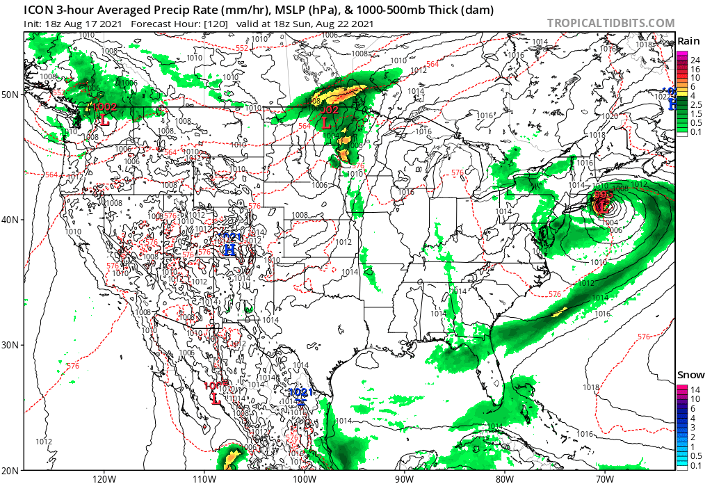
Last frame of ICON, henri has started to head nearly due west, from this point I do not know how much further west he would get if the run were extrapolated out. But the retrograde potential has been shown on at least the GFS and ICON, do not know what the 12z Euro showed,. This should not be taken at all for face value, just one of a ton possibilities including a wide right like sroc has said. BTW its pronounced "onree" according to what I have heard.

jmanley32- Senior Enthusiast

- Posts : 20535
Reputation : 108
Join date : 2013-12-12
Age : 43
Location : Yonkers, NY
rb924119 likes this post
 Re: 2021 Tropical Season
Jman I’ll respond to your messages after work, but I’ve gotta say the 00z NAM tonight is about as scary as it gets in terms of potential impacts for us. Not a good way to start the 00z suite. Even though it’s still at the end of its skilled range, seeing the adjustments it made in the short term is enough to spook me, especially when I strongly believe that the NAM is the best model inside of 3.5 days.
I’m at work, but I’ll try to post my quick thoughts as the 00z runs come in. FWIW, ICON making the same adjustments.
I’m at work, but I’ll try to post my quick thoughts as the 00z runs come in. FWIW, ICON making the same adjustments.
rb924119- Meteorologist

- Posts : 6928
Reputation : 194
Join date : 2013-02-06
Age : 32
Location : Greentown, Pa
 Re: 2021 Tropical Season
GFS Op trended with everything else tonight, landfalls eastern Long Island as a Cat-2. I expect the GFS Ensembles to look worse, as the operational has been chasing the southwestern periphery of them for days.
Last edited by rb924119 on Wed Aug 18, 2021 12:59 am; edited 1 time in total
rb924119- Meteorologist

- Posts : 6928
Reputation : 194
Join date : 2013-02-06
Age : 32
Location : Greentown, Pa
 Re: 2021 Tropical Season
rb924119 wrote:GFS Op trended with everything else tonight, landfalls central Long Island as a Cat-2. I expect thebGFS Ensembles to look worse, as the operational has been chasing the southwestern periphery of them for days.

weatherwatchermom- Senior Enthusiast

- Posts : 3793
Reputation : 78
Join date : 2014-11-25
Location : Hazlet Township, NJ
 Re: 2021 Tropical Season
We are the only 2 on...can't sleep..wtheck ...rb924119 wrote:GFS Op trended with everything else tonight, landfalls central Long Island as a Cat-2. I expect thebGFS Ensembles to look worse, as the operational has been chasing the southwestern periphery of them for days.

weatherwatchermom- Senior Enthusiast

- Posts : 3793
Reputation : 78
Join date : 2014-11-25
Location : Hazlet Township, NJ
 Re: 2021 Tropical Season
weatherwatchermom wrote:rb924119 wrote:GFS Op trended with everything else tonight, landfalls central Long Island as a Cat-2. I expect thebGFS Ensembles to look worse, as the operational has been chasing the southwestern periphery of them for days.what??
Eastern* Long Island. My bad.
But yeah, things got way worse in a hurry. Every model has come much more in line with me tonight, in fact, almost perfectly, but I don’t think we are done trending westward yet based on what I’m seeing tonight. As I expected the GFS Ensembles were scary, especially aloft, the GEM and the UKMET also caved, though the GEM isn’t quite there yet. Waiting on the EURO now, but I would expect it to follow everything else tonight and come in significantly further west.
rb924119- Meteorologist

- Posts : 6928
Reputation : 194
Join date : 2013-02-06
Age : 32
Location : Greentown, Pa
 Re: 2021 Tropical Season
that's not good are you still living down the shore. I am by Sandy hook..do you think it would effect us here??rb924119 wrote:weatherwatchermom wrote:rb924119 wrote:GFS Op trended with everything else tonight, landfalls central Long Island as a Cat-2. I expect thebGFS Ensembles to look worse, as the operational has been chasing the southwestern periphery of them for days.what??
Eastern* Long Island. My bad.
But yeah, things got way worse in a hurry. Every model has come much more in line with me tonight, in fact, almost perfectly, but I don’t think we are done trending westward yet based on what I’m seeing tonight. As I expected the GFS Ensembles were scary, especially aloft, the GEM and the UKMET also caved, though the GEM isn’t quite there yet. Waiting on the EURO now, but I would expect it to follow everything else tonight and come in significantly further west.

weatherwatchermom- Senior Enthusiast

- Posts : 3793
Reputation : 78
Join date : 2014-11-25
Location : Hazlet Township, NJ
 Re: 2021 Tropical Season
weatherwatchermom wrote:that's not good are you still living down the shore. I am by Sandy hook..do you think it would effect us here??rb924119 wrote:weatherwatchermom wrote:rb924119 wrote:GFS Op trended with everything else tonight, landfalls central Long Island as a Cat-2. I expect thebGFS Ensembles to look worse, as the operational has been chasing the southwestern periphery of them for days.what??
Eastern* Long Island. My bad.
But yeah, things got way worse in a hurry. Every model has come much more in line with me tonight, in fact, almost perfectly, but I don’t think we are done trending westward yet based on what I’m seeing tonight. As I expected the GFS Ensembles were scary, especially aloft, the GEM and the UKMET also caved, though the GEM isn’t quite there yet. Waiting on the EURO now, but I would expect it to follow everything else tonight and come in significantly further west.
I am!! Unfortunately, yes. I don’t think we are done trending with the westward extent of this storm, and I think our area (this forum’s as a whole) is very susceptible to this threat right now.
rb924119- Meteorologist

- Posts : 6928
Reputation : 194
Join date : 2013-02-06
Age : 32
Location : Greentown, Pa
Page 5 of 43 •  1, 2, 3, 4, 5, 6 ... 24 ... 43
Page 5 of 43
Permissions in this forum:
You cannot reply to topics in this forum|
|
|

 Home
Home
