
 Search
Long Range Discussion 22.0
Page 5 of 31 •  1, 2, 3, 4, 5, 6 ... 18 ... 31
 ![]()
Re: Long Range Discussion 22.0
![]() by sroc4 Thu Nov 11, 2021 3:18 pm
by sroc4 Thu Nov 11, 2021 3:18 pm
algae888 wrote:I should also add GEFS has below normal 850's day 9 thru the end of the run
Al id take anything you see beyond day 7-10 with a huge grain of salt. Remember the evolution we were follwoing for Nov 17th? What happened to the trough S of the Alutian islands that seemed likely, and what happened to the possible +PNA/-EPO couplet....transient:
GEFS


Euro ENS


There are still some questions about the PNA and EPO regions and the duration of which these features are around, but confidence is gaining on a +PNA, -EPO couplet is on the horizon. As an FYI the AO and NAO appear to hover around neutral to slight negative as we head beyond the 7-10 day time frame. It does appear there is at least some staying power to the BN to N temp regime in the NE, but time will tell.
Well here is the current GEFS Ens(Euro is the same) for 00z Nov 17th. As you can see there is a deep negative now over the WC of Canada and the north west CONUS. The trough coming on the heals of tomorrows rain for next week has no staying power. It gets booted by that energy crashing the coast and the result if the SE ridge immediately flexing 24hrs later.


Here is the next snap shot to follow. So long as there is a negative showing up along the WC of Canada and NW CONUS the cold will be transient. 2-4 days then out. The question will be as the next cold shot swings through can we get a storm track that brings in the cold first vs the SE ridge means warm out ahead and the cold only on the heals of the frontal boundary. If we can lay down some snow pack into NE over the next few weeks hopefully the cold air masses become more dense and diff to scour out.

sroc4- Admin

- Posts : 8331
Join date : 2013-01-07
Re: Long Range Discussion 22.0
![]() by sroc4 Thu Nov 11, 2021 4:03 pm
by sroc4 Thu Nov 11, 2021 4:03 pm
sroc4- Admin
- Posts : 8331
Join date : 2013-01-07
Re: Long Range Discussion 22.0
![]() by algae888 Thu Nov 11, 2021 5:04 pm
by algae888 Thu Nov 11, 2021 5:04 pm
Yea no problem Scott all good. I think what is a given is a negative WPO which usually correlates to a cold Canada. If we can get help from the EPO and PNA then we'll be in business. My thinking is that LA Nina's usually start fast and that's what I'm going with right now. Climo is hostile for snow right now however 12G EFS members and 15 EPS members give us an inch or more of snow by Thanksgiving. couple of heavy hitters within both of them not saying it's gonna happen and probably won't but we can't rule it outsroc4 wrote:Al I think Im the glass empty guy and your the half full guy. Between the two of us we have a full glass...lol I dont mean to be going against the grain here but I was thinking about writing up these thoughts anyway.

algae888- Advanced Forecaster

- Posts : 5311
Reputation : 46
Join date : 2013-02-05
Age : 61
Location : mt. vernon, new york
Re: Long Range Discussion 22.0
![]() by algae888 Thu Nov 11, 2021 5:06 pm
by algae888 Thu Nov 11, 2021 5:06 pm
Pretty good cold pool on our side. True PV is on other side of pole, but enough of one exists on this side and is pinned here allowing Canada to be cold. That looks to try to spill into the US. Also, 50mb strat PV aligns fairly well with the 500mb look. So it seems like there is some stability to the look. Normal caveats apply, but fingers crossed.
algae888- Advanced Forecaster
- Posts : 5311
Reputation : 46
Join date : 2013-02-05
Age : 61
Location : mt. vernon, new york
Re: Long Range Discussion 22.0
![]() by amugs Thu Nov 11, 2021 9:50 pm
by amugs Thu Nov 11, 2021 9:50 pm
He metrics for his forecast are MJO, ENSO, SUN Flares, Analog years that best match up with these. These are the maps he shared - I ran the meeting so I have these maps to share.
Overview
He thinks Dec is cold for the most part and chances of snow maybe a decent size storm.
January thinks we have a thaw and then we plunge deep into winter with one two possibly two big storms as the PV elongates. Thinks it will last through Midish February then the SE Ridge starts to erode teh cold as the wavelengths change. March is a typical March month temps up and down but not much precipitation.


Enjoy and thoughts?
_________________
Mugs
AKA:King: Snow Weenie
Self Proclaimed
WINTER 2014-15 : 55.12" +.02 for 6 coatings (avg. 35")
WINTER 2015-16 Total - 29.8" (Avg 35")
WINTER 2016-17 : 39.5" so far

amugs- Advanced Forecaster - Mod

- Posts : 15093
Reputation : 213
Join date : 2013-01-07
Age : 54
Location : Hillsdale,NJ
Re: Long Range Discussion 22.0
![]() by amugs Fri Nov 12, 2021 9:48 am
by amugs Fri Nov 12, 2021 9:48 am
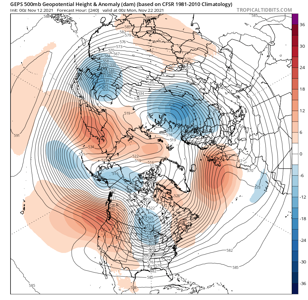
EPS
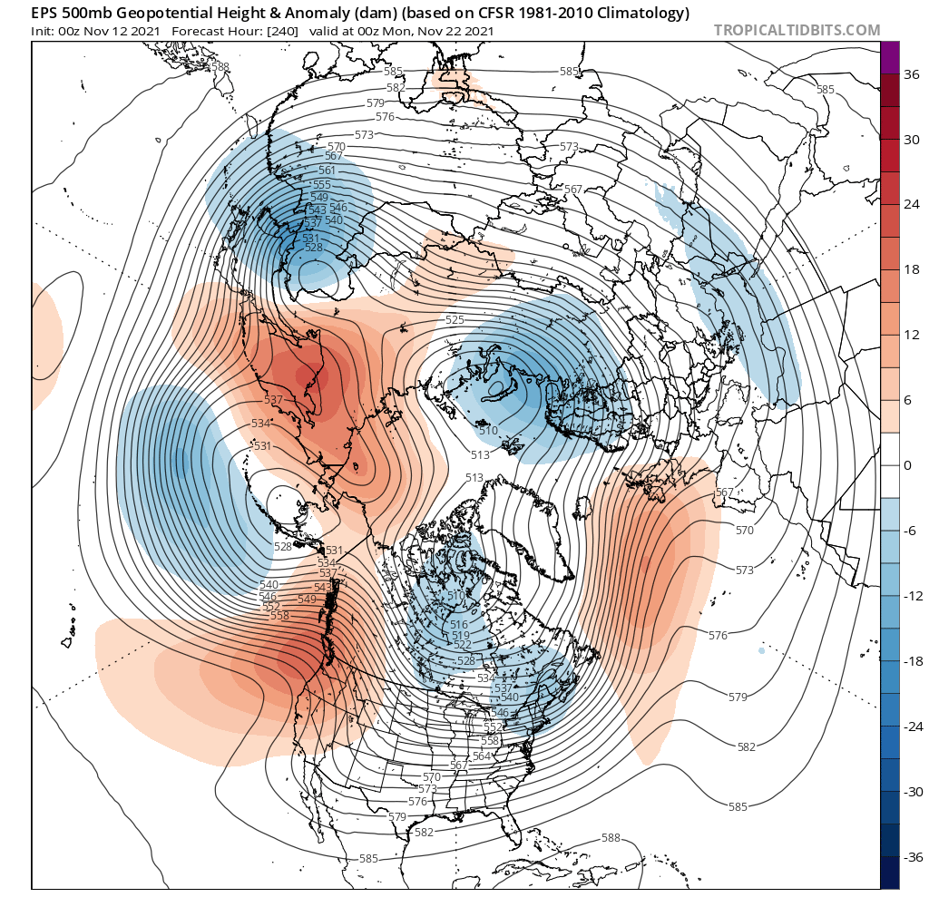
GEFS
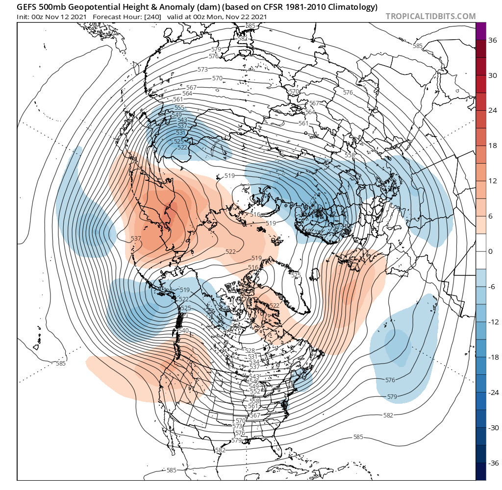
GEPS (AKA CANADIAN)
IF EPS wins then the EPO is Negative and we get a nice cold dump.
GEFS = mild pacific air
GEPS = Colder but not as with the EPO being Positive
_________________
Mugs
AKA:King: Snow Weenie
Self Proclaimed
WINTER 2014-15 : 55.12" +.02 for 6 coatings (avg. 35")
WINTER 2015-16 Total - 29.8" (Avg 35")
WINTER 2016-17 : 39.5" so far
amugs- Advanced Forecaster - Mod
- Posts : 15093
Reputation : 213
Join date : 2013-01-07
Age : 54
Location : Hillsdale,NJ
Re: Long Range Discussion 22.0
![]() by amugs Fri Nov 12, 2021 10:22 am
by amugs Fri Nov 12, 2021 10:22 am
For the last week or so, we've hinted at a potential active second half of November. The upper level pattern is reverting back to trough/storm systems eastern US Thanksgiving week. No big surprise here. Rain or snow? Too soon to tell @fox8news pic.twitter.com/9jCAAJ6CLt
— Scott Sabol, Meteorologist CBM/CCM (@ScottSabolFOX8) November 12, 2021
_________________
Mugs
AKA:King: Snow Weenie
Self Proclaimed
WINTER 2014-15 : 55.12" +.02 for 6 coatings (avg. 35")
WINTER 2015-16 Total - 29.8" (Avg 35")
WINTER 2016-17 : 39.5" so far
amugs- Advanced Forecaster - Mod
- Posts : 15093
Reputation : 213
Join date : 2013-01-07
Age : 54
Location : Hillsdale,NJ
Re: Long Range Discussion 22.0
![]() by heehaw453 Sat Nov 13, 2021 10:12 am
by heehaw453 Sat Nov 13, 2021 10:12 am
DT Winter Outlook
heehaw453- Advanced Forecaster
- Posts : 3906
Reputation : 86
Join date : 2014-01-20
Location : Bedminster Township, PA Elevation 600' ASL
Re: Long Range Discussion 22.0
![]() by dkodgis Sat Nov 13, 2021 11:40 am
by dkodgis Sat Nov 13, 2021 11:40 am

dkodgis- Senior Enthusiast

- Posts : 2498
Reputation : 98
Join date : 2013-12-29
heehaw453 likes this post
Re: Long Range Discussion 22.0
![]() by amugs Sat Nov 13, 2021 2:45 pm
by amugs Sat Nov 13, 2021 2:45 pm
4 straight runs. We'll see

_________________
Mugs
AKA:King: Snow Weenie
Self Proclaimed
WINTER 2014-15 : 55.12" +.02 for 6 coatings (avg. 35")
WINTER 2015-16 Total - 29.8" (Avg 35")
WINTER 2016-17 : 39.5" so far
amugs- Advanced Forecaster - Mod
- Posts : 15093
Reputation : 213
Join date : 2013-01-07
Age : 54
Location : Hillsdale,NJ
heehaw453 and weatherwatchermom like this post
Re: Long Range Discussion 22.0
![]() by SENJsnowman Sat Nov 13, 2021 4:50 pm
by SENJsnowman Sat Nov 13, 2021 4:50 pm
heehaw453 wrote:Another take on the winter outlook. DT placing a lot of emphasis on the location and strength of the La Nina.
DT Winter Outlook
Very interesting and easy to digest indeed. And encouraging for the winter weather weenies! I copied/pasted the highlights of his summary pages as well as what might go wrong. I also italicized the one sentence in the summary that I found most intriguing. Enjoy!
SUMMARY WINTER 2021-22
The CONSENSUS forecast (from CPC, etc. ) that this La Nina is like one last winter is without any merit whatsoever.
Moreover the view that all La Nina events are the same and bring the same winter patterns is equally false.
The La Nina of 2021-22 will be a WEAK event. It may briefly reach Moderate threshold in DEC, then weaken steadily
Weak La Nina winters are VERY different from Moderate/ Strong La Nina. They are colder and offer more blocking patterns that allow for winter storms in the central and eastern CONUS that are not nearly as dry.
This weak La Nina will be CP/ central Pacific based. The combination of CP and Weak La Nina supports what could be a cold, stormy winter for the central and eastern CONUS.
The winter in the central and eastern CONUS will get off to a relatively early start in the eastern CONUS and along the West Coast and northern Rockies.
Research shows that back to back La Nina winters always show the 2ndLa Nina to be WEAK, and the 2ndLa Nina winters are substantially colder and wetter than regular La Nina winters.
The 500mb climo of weak Central Pacific La Nina winter is quite stormy and cold for eastern half of the CONUS.
The QBO TREND of 2021, matches several of the severe cold & snowier winters of the past.
WHAT COULD GO WRONG?
As the Weak La Nina fades, other factors will come into play. One factor is the large pool of cold SSTA (Sea Surface Temperature Anomalies) in the Northeast Pacific.
This cold water has increased SIGNIFICANTLY in OCT, as several massive intense Low pressure areas in the NE Pacific have generated “upwelling” of colder water.
In the 2d half of the winter, IF the –AO and or the –NAO fade, then the –PDO will take over as the primary driving force. This would turn the pattern warm in FEB 2022.
SENJsnowman- Senior Enthusiast
- Posts : 1186
Reputation : 61
Join date : 2017-01-06
Age : 51
Location : Bayville, NJ
heehaw453 and weatherwatchermom like this post
Re: Long Range Discussion 22.0
![]() by amugs Sat Nov 13, 2021 7:44 pm
by amugs Sat Nov 13, 2021 7:44 pm

GEFS saying NAO over feature for Turkey week. Please be right!
_________________
Mugs
AKA:King: Snow Weenie
Self Proclaimed
WINTER 2014-15 : 55.12" +.02 for 6 coatings (avg. 35")
WINTER 2015-16 Total - 29.8" (Avg 35")
WINTER 2016-17 : 39.5" so far
amugs- Advanced Forecaster - Mod
- Posts : 15093
Reputation : 213
Join date : 2013-01-07
Age : 54
Location : Hillsdale,NJ
weatherwatchermom and Irish like this post
Re: Long Range Discussion 22.0
![]() by sroc4 Sun Nov 14, 2021 10:31 am
by sroc4 Sun Nov 14, 2021 10:31 am

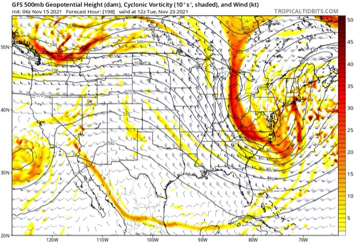
The image above is a snap shot of the current 500mb pattern. Below is the same image. I have to take a quick moment to acknowledge the two Als (Mugsy and Algae) because they have been talking about "the building of the cold air over Canada". The way I see it this statement cant be understated in its importance as we head into December. Let's talk about that.
Focus now on the image below and the WPO region. The orange colors indicate a strong ridge in this region(-WPO). Recall ridging = high pressure and clockwise winds, and Troughing(blue colors) = Low Pressure and counterclockwise winds. Now follow the arrows. With the -WPO in place what you get is a cross polar flow that leads to very cold air building in the area defined by the thin black circle.

Now lets focus on the EPO and PNA regions. The blue colors indicate a +EPO(trough). Even though its not a strong +PNA(more appropriate the PNA is not negative), the ridging in the PNA region allows the cold air to bleed S and E into our neck of the woods as energy from the EPO region marches eastward. BUT, because the EPO is positive it allows Pac energy to persistently/continually crash the N half of the west coast(WC) of North America(NA) which flattens the ridging in the PNA region; keeping things in a bit of a transient pattern. In the image below notice the linkage between the negatives(blue colors).

So basically the current pattern is such that over the next couple of weeks you get waves of energy from from the pacific coming into the west coast of Northern NA, flattening the ridging in the PNA region. As it heads east, ridge in the PNA region goes back up(albiet weakly), which allows the energy to then drop into S central Canada and the northern plains. While this is happening the next piece of Pac energy(as you can see in the image below) is crashing the WC of northern NA which flattens the PNA yet again. The flattening of the PNA allows the Polar energy to interact with the energy in the subtropical jet early which leads to a storm track less than ideal. ie: SE ridge flexes a tad, we get warm sectored out ahead of the storm, we get rain followed by the cold air coming in behind it. Rinse, wash, repeat for the time being.

But here is the thing. A storm track and pattern like this will lead to the building of the snow pack in the region outlined below. Again going back to "the building of the cold air over Canada" statement above cant be understated. BECAUSE, as the snow pack builds, so will the ability of the cold air to infiltrate further and further south and east. Cold air is much more dense than warm air and eventually we will get cold air to bleed far enough s&E such that the interactions between the Polar and sub tropical energy will be late enough to bring snow into the region. Obv it starts with areas N&W and eventually down to the coast.

There is some rumblings in the modeling regarding the AO and or NAO becoming more favorable. When of IF that happens, AND the snow pack in Canada builds, the pattern will shift such that the ability for the energy to phase early and slip to our west will begin to shift further east increasing the chances for snow. Time will tell.
_________________
"In weather and in life, there's no winning and losing; there's only winning and learning."
WINTER 2012/2013 TOTALS 43.65"WINTER 2017/2018 TOTALS 62.85" WINTER 2022/2023 TOTALS 4.9"
WINTER 2013/2014 TOTALS 64.85"WINTER 2018/2019 TOTALS 14.25" WINTER 2023/2024 TOTALS 13.1"
WINTER 2014/2015 TOTALS 71.20"WINTER 2019/2020 TOTALS 6.35"
WINTER 2015/2016 TOTALS 35.00"WINTER 2020/2021 TOTALS 37.75"
WINTER 2016/2017 TOTALS 42.25"WINTER 2021/2022 TOTALS 31.65"

sroc4- Admin
- Posts : 8331
Reputation : 301
Join date : 2013-01-07
Location : Wading River, LI
weatherwatchermom, SENJsnowman and Irish like this post
Re: Long Range Discussion 22.0
![]() by amugs Sun Nov 14, 2021 2:45 pm
by amugs Sun Nov 14, 2021 2:45 pm
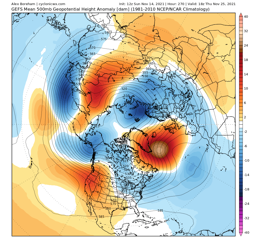
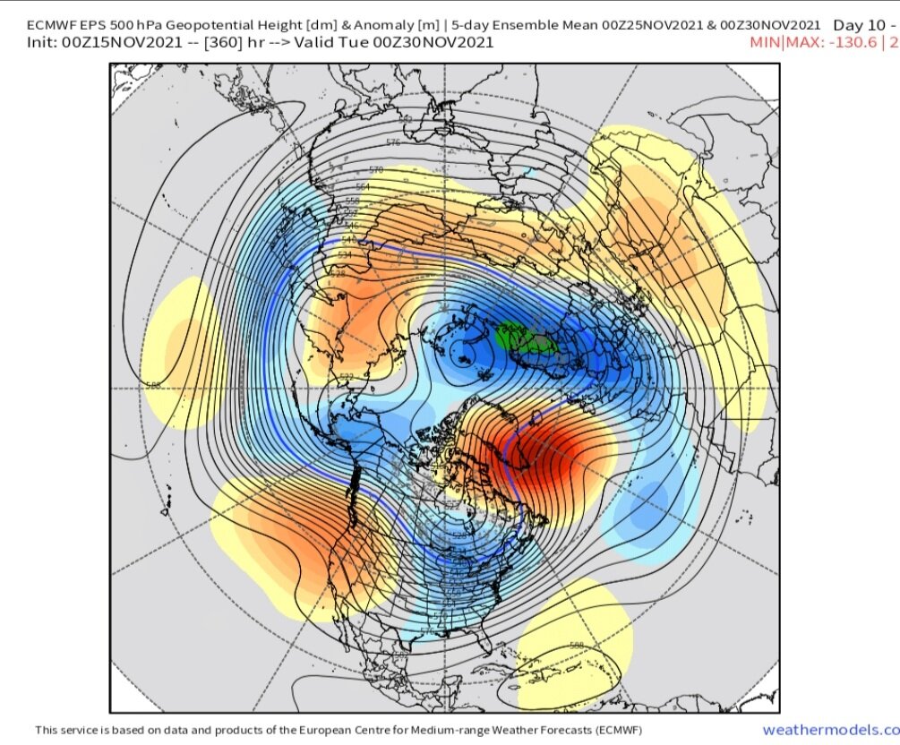
Low solar and a bombardment of cosmic rays (protons, plasma particles, and neutrons) for the past years is going to ay off as it has a lag affect on the weather patterns and make teh jet stream adn structure Meridional (wavy, North to South) giving one side tropical warmth and the other side brutal polar/arctic cold). So ups and downs abound but remember we informed about this!
Nice map for sure.
_________________
Mugs
AKA:King: Snow Weenie
Self Proclaimed
WINTER 2014-15 : 55.12" +.02 for 6 coatings (avg. 35")
WINTER 2015-16 Total - 29.8" (Avg 35")
WINTER 2016-17 : 39.5" so far
amugs- Advanced Forecaster - Mod
- Posts : 15093
Reputation : 213
Join date : 2013-01-07
Age : 54
Location : Hillsdale,NJ
Re: Long Range Discussion 22.0
![]() by amugs Mon Nov 15, 2021 11:03 am
by amugs Mon Nov 15, 2021 11:03 am
_________________
Mugs
AKA:King: Snow Weenie
Self Proclaimed
WINTER 2014-15 : 55.12" +.02 for 6 coatings (avg. 35")
WINTER 2015-16 Total - 29.8" (Avg 35")
WINTER 2016-17 : 39.5" so far
amugs- Advanced Forecaster - Mod
- Posts : 15093
Reputation : 213
Join date : 2013-01-07
Age : 54
Location : Hillsdale,NJ
Re: Long Range Discussion 22.0
![]() by amugs Mon Nov 15, 2021 12:32 pm
by amugs Mon Nov 15, 2021 12:32 pm
amugs wrote:Need to keep an eye on this vorticity for Nor'Easter development next week - long ways out but the pie has teh ingredients - just need it to come together!
12Z just said yes it is possible - especially interior with cold air available

_________________
Mugs
AKA:King: Snow Weenie
Self Proclaimed
WINTER 2014-15 : 55.12" +.02 for 6 coatings (avg. 35")
WINTER 2015-16 Total - 29.8" (Avg 35")
WINTER 2016-17 : 39.5" so far
amugs- Advanced Forecaster - Mod
- Posts : 15093
Reputation : 213
Join date : 2013-01-07
Age : 54
Location : Hillsdale,NJ
dkodgis- Senior Enthusiast
- Posts : 2498
Reputation : 98
Join date : 2013-12-29

algae888- Advanced Forecaster
- Posts : 5311
Reputation : 46
Join date : 2013-02-05
Age : 61
Location : mt. vernon, new york
sroc4 likes this post

algae888- Advanced Forecaster
- Posts : 5311
Reputation : 46
Join date : 2013-02-05
Age : 61
Location : mt. vernon, new york
sroc4 likes this post
Re: Long Range Discussion 22.0
![]() by algae888 Mon Nov 15, 2021 4:40 pm
by algae888 Mon Nov 15, 2021 4:40 pm
algae888- Advanced Forecaster
- Posts : 5311
Reputation : 46
Join date : 2013-02-05
Age : 61
Location : mt. vernon, new york
sroc4 likes this post
Re: Long Range Discussion 22.0
![]() by algae888 Mon Nov 15, 2021 4:54 pm
by algae888 Mon Nov 15, 2021 4:54 pm
algae888- Advanced Forecaster
- Posts : 5311
Reputation : 46
Join date : 2013-02-05
Age : 61
Location : mt. vernon, new york
sroc4 likes this post
algae888- Advanced Forecaster
- Posts : 5311
Reputation : 46
Join date : 2013-02-05
Age : 61
Location : mt. vernon, new york
sroc4 likes this post
Re: Long Range Discussion 22.0
![]() by algae888 Mon Nov 15, 2021 5:07 pm
by algae888 Mon Nov 15, 2021 5:07 pm
"One final round of strengthening does not bother me in the slightest. I would be more concerned if it were becoming a modoki and remaining the same intensity. A marked drop that is relegated to the eastern zones is a recipe for a relatively fruitful la nina season for east coast winter enthusiasts."
"I will go to the grave swearing that Jan 2011 would not have been so epic if la nina were weaker....strong east based la nina and modoki el nino events are rare birds, and it's why seasons like 2010-2011, 2002-2003 and 2009-10 are so exceptional. It's about the location of the forcing, and it is well placed, then you want it to be a very prominent hemispheric driver. "
algae888- Advanced Forecaster
- Posts : 5311
Reputation : 46
Join date : 2013-02-05
Age : 61
Location : mt. vernon, new york
sroc4 likes this post
Re: Long Range Discussion 22.0
![]() by amugs Mon Nov 15, 2021 9:24 pm
by amugs Mon Nov 15, 2021 9:24 pm
Our potential storm in 7-8 days might set off a cyclonic wave-break, something that would significantly amplify the -NAO. This could cause the pattern to get rather amplified and backed up by the end of November, potentially bringing a prolonged period of interesting weather. pic.twitter.com/2H7CxQzAKh
— Nikhil Trivedi (@DCAreaWx) November 16, 2021
_________________
Mugs
AKA:King: Snow Weenie
Self Proclaimed
WINTER 2014-15 : 55.12" +.02 for 6 coatings (avg. 35")
WINTER 2015-16 Total - 29.8" (Avg 35")
WINTER 2016-17 : 39.5" so far
amugs- Advanced Forecaster - Mod
- Posts : 15093
Reputation : 213
Join date : 2013-01-07
Age : 54
Location : Hillsdale,NJ
Re: Long Range Discussion 22.0
![]() by Frank_Wx Tue Nov 16, 2021 8:14 am
by Frank_Wx Tue Nov 16, 2021 8:14 am
_________________
_______________________________________________________________________________________________________
CLICK HERE to view NJ Strong Snowstorm Classifications

Frank_Wx- Godzilla Seeker
- Posts : 21305
Reputation : 328
Join date : 2013-01-05
Age : 31
Location : Jersey City, NJ -

amugs, SENJsnowman and Irish like this post
Re: Long Range Discussion 22.0
![]() by amugs Tue Nov 16, 2021 10:13 am
by amugs Tue Nov 16, 2021 10:13 am

_________________
Mugs
AKA:King: Snow Weenie
Self Proclaimed
WINTER 2014-15 : 55.12" +.02 for 6 coatings (avg. 35")
WINTER 2015-16 Total - 29.8" (Avg 35")
WINTER 2016-17 : 39.5" so far
amugs- Advanced Forecaster - Mod
- Posts : 15093
Reputation : 213
Join date : 2013-01-07
Age : 54
Location : Hillsdale,NJ
phil155 likes this post
Re: Long Range Discussion 22.0
![]() by sroc4 Wed Nov 17, 2021 12:42 pm
by sroc4 Wed Nov 17, 2021 12:42 pm
Still way too much time and too many model runs to get excited, or write anything off just yet.
_________________
"In weather and in life, there's no winning and losing; there's only winning and learning."
WINTER 2012/2013 TOTALS 43.65"WINTER 2017/2018 TOTALS 62.85" WINTER 2022/2023 TOTALS 4.9"
WINTER 2013/2014 TOTALS 64.85"WINTER 2018/2019 TOTALS 14.25" WINTER 2023/2024 TOTALS 13.1"
WINTER 2014/2015 TOTALS 71.20"WINTER 2019/2020 TOTALS 6.35"
WINTER 2015/2016 TOTALS 35.00"WINTER 2020/2021 TOTALS 37.75"
WINTER 2016/2017 TOTALS 42.25"WINTER 2021/2022 TOTALS 31.65"
sroc4- Admin
- Posts : 8331
Reputation : 301
Join date : 2013-01-07
Location : Wading River, LI
weatherwatchermom, SENJsnowman and phil155 like this post
Page 5 of 31 • 1, 2, 3, 4, 5, 6 ... 18 ... 31 ![]()
|
|
|