
 Search
January 2022 Obs & Discussions
Page 4 of 19 •  1, 2, 3, 4, 5 ... 11 ... 19
 ![]()
Re: January 2022 Obs & Discussions
![]() by Frank_Wx Sun Jan 02, 2022 8:04 am
by Frank_Wx Sun Jan 02, 2022 8:04 am
Temperatures are expected to fall 25+ degrees overnight after the passage of a cold front. Whatever snow does fall , especially across NNJ, is going to be higher than a 10:1 ratio. Probably more like 15:1. Here’s a look at how much precip falls on the latest EPS:

The dark green shading is about 3-5” of snow while light green is 1-3”. As you progress more south into the blue shade you’re looking at 6”+ of snow. Clearly, SNJ into the Mid Atlantic will be the jackpot where significant snow will fall. I’m fairly confident in saying that considering the setup. The tricker forecast is NYC because they’re right on the gradient. A tick more north and the city is looking at 3-6” of snow.
Until we get clarity I am putting the city in 2-4” of snow. This includes Long Island and NNJ (excluding extreme northern and NW NJ). Then as you go south from there you’re looking at potentially 4”+ of snow.
Start time is 4am Monday. End time is 4pm Monday. Relatively fast mover.
Frank_Wx- Godzilla Seeker

- Posts : 21308
Join date : 2013-01-05 -

Re: January 2022 Obs & Discussions
![]() by SENJsnowman Sun Jan 02, 2022 8:27 am
by SENJsnowman Sun Jan 02, 2022 8:27 am
Thread! Thread! Thread!
SENJsnowman- Senior Enthusiast

- Posts : 1195
Join date : 2017-01-06
Re: January 2022 Obs & Discussions
![]() by Snow88 Sun Jan 02, 2022 8:34 am
by Snow88 Sun Jan 02, 2022 8:34 am

Snow88- Senior Enthusiast
- Posts : 2193
Reputation : 4
Join date : 2013-01-09
Age : 36
Location : Brooklyn, NY
Re: January 2022 Obs & Discussions
![]() by SENJsnowman Sun Jan 02, 2022 8:38 am
by SENJsnowman Sun Jan 02, 2022 8:38 am
BUT, for our southern friends (Monmouth County south) the latest Mt Holly discussion is very enticing:
"Colder air will be rushing into the region tonight. Temperatures
will fall through the night, eventually near to below freezing
across the entire area. Steady precipitation should begin to move in
during the middle to latter portion of the night, starting to the
southwest. Initially, temperatures will probably remain warm enough
for it to begin as rain across the southern zones. With time,
continued infiltration of cold air and increasing precipitation
intensity should support a flip to snow. Several hours of moderate
to potentially heavy snow are then likely from early Monday morning
into Monday afternoon. Snowfall rates of 1 inch per hour or greater
at times will be possible in the Winter Storm Watch area. As the
wave of low pressure pulls away, snow should end during the late
afternoon or evening hours, from southwest to northeast.
Regarding amounts, antecedent warm conditions and the warm ground
are certainly a consideration, and snow ratios will likely be well
below 10:1 at least at first. However, during the more intense
period of snow, the warm ground could easily be overwhelmed. A multi-
cycle model QPF blend and snow ratio blend yielded a swath of 4 to 6
inches of snow, locally a little higher, across our southern zones.
There is likely to be a sharp cutoff to the north due to very dry
air invading along with the cold. The cutoff to the north will
probably be sharper than currently forecast. Should the northern
trend continue even more, it`s even possible mixing with rain could
become a factor across the south, and that the higher snow amounts
could shift further north.
Hard to overstate how high the uncertainty remains with this system
due to how quickly the forecast is evolving. Looking at some of the
initial 02.06z runs, it`s possible areas well north of the watch
could also be in play for significant snow, even approaching metro
Philly. And it`s possible current forecast maximum amounts could be
considerably too low, and they will be if the overnight guidance is
correct. But definitely did not want to jerk the forecast all the
way in that direction at once; the current forecast already
constitutes a major change. Once again, continue to closely monitor
the forecast today."
I suppose some of that last talk would have a big impact on CNJ and NYC if it were to happen.
SENJsnowman- Senior Enthusiast
- Posts : 1195
Reputation : 61
Join date : 2017-01-06
Age : 51
Location : Long Branch, NJ
Re: January 2022 Obs & Discussions
![]() by heehaw453 Sun Jan 02, 2022 8:49 am
by heehaw453 Sun Jan 02, 2022 8:49 am
SENJsnowman wrote:Ok, so maybe premature on the thread talk until more of this forum area is in a real high impact zone.
BUT, for our southern friends (Monmouth County south) the latest Mt Holly discussion is very enticing:
"Colder air will be rushing into the region tonight. Temperatures
will fall through the night, eventually near to below freezing
across the entire area. Steady precipitation should begin to move in
during the middle to latter portion of the night, starting to the
southwest. Initially, temperatures will probably remain warm enough
for it to begin as rain across the southern zones. With time,
continued infiltration of cold air and increasing precipitation
intensity should support a flip to snow. Several hours of moderate
to potentially heavy snow are then likely from early Monday morning
into Monday afternoon. Snowfall rates of 1 inch per hour or greater
at times will be possible in the Winter Storm Watch area. As the
wave of low pressure pulls away, snow should end during the late
afternoon or evening hours, from southwest to northeast.
Regarding amounts, antecedent warm conditions and the warm ground
are certainly a consideration, and snow ratios will likely be well
below 10:1 at least at first. However, during the more intense
period of snow, the warm ground could easily be overwhelmed. A multi-
cycle model QPF blend and snow ratio blend yielded a swath of 4 to 6
inches of snow, locally a little higher, across our southern zones.
There is likely to be a sharp cutoff to the north due to very dry
air invading along with the cold. The cutoff to the north will
probably be sharper than currently forecast. Should the northern
trend continue even more, it`s even possible mixing with rain could
become a factor across the south, and that the higher snow amounts
could shift further north.
Hard to overstate how high the uncertainty remains with this system
due to how quickly the forecast is evolving. Looking at some of the
initial 02.06z runs, it`s possible areas well north of the watch
could also be in play for significant snow, even approaching metro
Philly. And it`s possible current forecast maximum amounts could be
considerably too low, and they will be if the overnight guidance is
correct. But definitely did not want to jerk the forecast all the
way in that direction at once; the current forecast already
constitutes a major change. Once again, continue to closely monitor
the forecast today."
I suppose some of that last talk would have a big impact on CNJ and NYC if it were to happen.
Enjoy this snowman! You are in a good spot and don't see less than 6 inches along NJ coast from Pt Pleasant south. The only limiting factor is it's a fast mover and there will be struggle to accumulate until the surface temps crash and the intensity picks up, but regardless you are still in line for significant snow. My guess Barnegat area could be 6-9". Probably will look like a blizzard for a time as the wind picks up due to deepening LP. I'm tempted to visit the in-laws tonight who live down there.
heehaw453- Advanced Forecaster

- Posts : 3907
Reputation : 86
Join date : 2014-01-20
Location : Bedminster Township, PA Elevation 600' ASL
larryrock72 likes this post
Re: January 2022 Obs & Discussions
![]() by heehaw453 Sun Jan 02, 2022 8:55 am
by heehaw453 Sun Jan 02, 2022 8:55 am

heehaw453- Advanced Forecaster
- Posts : 3907
Reputation : 86
Join date : 2014-01-20
Location : Bedminster Township, PA Elevation 600' ASL
larryrock72 likes this post
Re: January 2022 Obs & Discussions
![]() by SENJsnowman Sun Jan 02, 2022 9:00 am
by SENJsnowman Sun Jan 02, 2022 9:00 am
And I'm telling you all, that this setting up EXACTLY like Jan 7, 2017 where the precip shield exploded NW on game day and as I recall folks as far north as JMAN cashed in for several unexpected inches. If that low sets up off the coast and strengthens, I think that could possibly expand the precip shield, enhance the precip rates AND slow the storm a bit. All 3 of these things happened 1/7/17 in a very similar set up.
So, keep the faith and keep tracking! Still not over yet!
SENJsnowman- Senior Enthusiast
- Posts : 1195
Reputation : 61
Join date : 2017-01-06
Age : 51
Location : Long Branch, NJ
larryrock72 likes this post
Re: January 2022 Obs & Discussions
![]() by larryrock72 Sun Jan 02, 2022 9:04 am
by larryrock72 Sun Jan 02, 2022 9:04 am
What a 24hr change. Unbelievable. My concern will the temps crash fast enough to get that quick changeover along the coast where we live.
larryrock72- Posts : 141
Reputation : 5
Join date : 2017-01-03
Age : 52
Location : Barnegat, NJ
Re: January 2022 Obs & Discussions
![]() by Dunnzoo Sun Jan 02, 2022 9:06 am
by Dunnzoo Sun Jan 02, 2022 9:06 am
_________________
Janet
Snowfall winter of 2023-2024 17.5"
Snowfall winter of 2022-2023 6.0"
Snowfall winter of 2021-2022 17.6" 1" sleet 2/25/22
Snowfall winter of 2020-2021 51.1"
Snowfall winter of 2019-2020 8.5"
Snowfall winter of 2018-2019 25.1"
Snowfall winter of 2017-2018 51.9"
Snowfall winter of 2016-2017 45.6"
Snowfall winter of 2015-2016 29.5"
Snowfall winter of 2014-2015 50.55"
Snowfall winter of 2013-2014 66.5"

Dunnzoo- Senior Enthusiast - Mod

- Posts : 4920
Reputation : 68
Join date : 2013-01-11
Age : 62
Location : Westwood, NJ
SENJsnowman likes this post
Re: January 2022 Obs & Discussions
![]() by Snow88 Sun Jan 02, 2022 9:10 am
by Snow88 Sun Jan 02, 2022 9:10 am
Snow88- Senior Enthusiast
- Posts : 2193
Reputation : 4
Join date : 2013-01-09
Age : 36
Location : Brooklyn, NY
larryrock72- Posts : 141
Reputation : 5
Join date : 2017-01-03
Age : 52
Location : Barnegat, NJ
Re: January 2022 Obs & Discussions
![]() by Frank_Wx Sun Jan 02, 2022 9:18 am
by Frank_Wx Sun Jan 02, 2022 9:18 am
_________________
_______________________________________________________________________________________________________
CLICK HERE to view NJ Strong Snowstorm Classifications

Frank_Wx- Godzilla Seeker
- Posts : 21308
Reputation : 328
Join date : 2013-01-05
Age : 32
Location : Jersey City, NJ -
larryrock72 and SENJsnowman like this post
Re: January 2022 Obs & Discussions
![]() by Snow88 Sun Jan 02, 2022 9:24 am
by Snow88 Sun Jan 02, 2022 9:24 am
Snow88- Senior Enthusiast
- Posts : 2193
Reputation : 4
Join date : 2013-01-09
Age : 36
Location : Brooklyn, NY
Re: January 2022 Obs & Discussions
![]() by dsix85 Sun Jan 02, 2022 9:26 am
by dsix85 Sun Jan 02, 2022 9:26 am
dsix85- Pro Enthusiast

- Posts : 349
Reputation : 8
Join date : 2014-01-01
Location : New York
Re: January 2022 Obs & Discussions
![]() by SENJsnowman Sun Jan 02, 2022 9:31 am
by SENJsnowman Sun Jan 02, 2022 9:31 am
CP said it- when you have 1” on the ground, a full sky and a full radar, THEN you have a snowstorm. Until then, it’s conjecture.
So, time for me to celebrate less and track some more I guess.
SENJsnowman- Senior Enthusiast
- Posts : 1195
Reputation : 61
Join date : 2017-01-06
Age : 51
Location : Long Branch, NJ
Re: January 2022 Obs & Discussions
![]() by amugs Sun Jan 02, 2022 9:54 am
by amugs Sun Jan 02, 2022 9:54 am
_________________
Mugs
AKA:King: Snow Weenie
Self Proclaimed
WINTER 2014-15 : 55.12" +.02 for 6 coatings (avg. 35")
WINTER 2015-16 Total - 29.8" (Avg 35")
WINTER 2016-17 : 39.5" so far

amugs- Advanced Forecaster - Mod
- Posts : 15130
Reputation : 213
Join date : 2013-01-07
Age : 54
Location : Hillsdale,NJ
Re: January 2022 Obs & Discussions
![]() by amugs Sun Jan 02, 2022 9:54 am
by amugs Sun Jan 02, 2022 9:54 am
amugs wrote:Happy New Year Fam and let's get this party started right!
Monday has a shot, albeit not much but it's still on the table. Need this piece of Energy over NE called confluence to relax more and the Northern energy over the Great Lake's to speed up a tad and catch the Main stream over VA Caoes region or Delmarva and we can have a moderate event for the NYC region and especially CNJ/Coastal NJ and LI.
Right now SNJ - say about Brick/Pt. PT Pleasantleasant looks to be in a good spot for Mondays storm and extended holiday vacay for the kids!!!
From 33 n Rain ShowMe - Great visual maps

Bump baby!!
_________________
Mugs
AKA:King: Snow Weenie
Self Proclaimed
WINTER 2014-15 : 55.12" +.02 for 6 coatings (avg. 35")
WINTER 2015-16 Total - 29.8" (Avg 35")
WINTER 2016-17 : 39.5" so far
amugs- Advanced Forecaster - Mod
- Posts : 15130
Reputation : 213
Join date : 2013-01-07
Age : 54
Location : Hillsdale,NJ
Re: January 2022 Obs & Discussions
![]() by heehaw453 Sun Jan 02, 2022 10:08 am
by heehaw453 Sun Jan 02, 2022 10:08 am
heehaw453- Advanced Forecaster
- Posts : 3907
Reputation : 86
Join date : 2014-01-20
Location : Bedminster Township, PA Elevation 600' ASL
Frank_Wx likes this post
Re: January 2022 Obs & Discussions
![]() by heehaw453 Sun Jan 02, 2022 5:20 pm
by heehaw453 Sun Jan 02, 2022 5:20 pm


heehaw453- Advanced Forecaster
- Posts : 3907
Reputation : 86
Join date : 2014-01-20
Location : Bedminster Township, PA Elevation 600' ASL
Re: January 2022 Obs & Discussions
![]() by heehaw453 Sun Jan 02, 2022 9:03 pm
by heehaw453 Sun Jan 02, 2022 9:03 pm

heehaw453- Advanced Forecaster
- Posts : 3907
Reputation : 86
Join date : 2014-01-20
Location : Bedminster Township, PA Elevation 600' ASL
Re: January 2022 Obs & Discussions
![]() by heehaw453 Mon Jan 03, 2022 9:27 am
by heehaw453 Mon Jan 03, 2022 9:27 am
heehaw453- Advanced Forecaster
- Posts : 3907
Reputation : 86
Join date : 2014-01-20
Location : Bedminster Township, PA Elevation 600' ASL
Re: January 2022 Obs & Discussions
![]() by sroc4 Mon Jan 03, 2022 9:45 am
by sroc4 Mon Jan 03, 2022 9:45 am
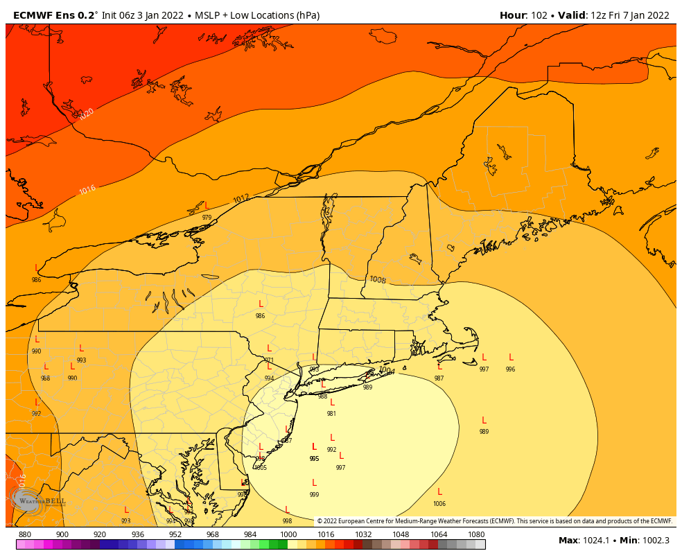
heehaw453 wrote:Both major model ensembles have the signal for a significant storm on Thursday night/Friday at D3+. EPS is tucked and GFS is more towards BM track. Based on the h5 consistency it's becoming more likely this occurs. The who gets what is dependent on the western ridge as well as the baroclinic zone. Kind of nice to be tracking this setup. We shall see...
I havent had more than a brief look into this one yet but Miller B type set up which can be tricky. Always a screw zone of subsidence
_________________
"In weather and in life, there's no winning and losing; there's only winning and learning."
WINTER 2012/2013 TOTALS 43.65"WINTER 2017/2018 TOTALS 62.85" WINTER 2022/2023 TOTALS 4.9"
WINTER 2013/2014 TOTALS 64.85"WINTER 2018/2019 TOTALS 14.25" WINTER 2023/2024 TOTALS 13.1"
WINTER 2014/2015 TOTALS 71.20"WINTER 2019/2020 TOTALS 6.35"
WINTER 2015/2016 TOTALS 35.00"WINTER 2020/2021 TOTALS 37.75"
WINTER 2016/2017 TOTALS 42.25"WINTER 2021/2022 TOTALS 31.65"

sroc4- Admin
- Posts : 8441
Reputation : 302
Join date : 2013-01-07
Location : Wading River, LI
Re: January 2022 Obs & Discussions
![]() by amugs Mon Jan 03, 2022 9:56 am
by amugs Mon Jan 03, 2022 9:56 am
_________________
Mugs
AKA:King: Snow Weenie
Self Proclaimed
WINTER 2014-15 : 55.12" +.02 for 6 coatings (avg. 35")
WINTER 2015-16 Total - 29.8" (Avg 35")
WINTER 2016-17 : 39.5" so far
amugs- Advanced Forecaster - Mod
- Posts : 15130
Reputation : 213
Join date : 2013-01-07
Age : 54
Location : Hillsdale,NJ
Re: January 2022 Obs & Discussions
![]() by amugs Mon Jan 03, 2022 10:15 am
by amugs Mon Jan 03, 2022 10:15 am

_________________
Mugs
AKA:King: Snow Weenie
Self Proclaimed
WINTER 2014-15 : 55.12" +.02 for 6 coatings (avg. 35")
WINTER 2015-16 Total - 29.8" (Avg 35")
WINTER 2016-17 : 39.5" so far
amugs- Advanced Forecaster - Mod
- Posts : 15130
Reputation : 213
Join date : 2013-01-07
Age : 54
Location : Hillsdale,NJ
Re: January 2022 Obs & Discussions
![]() by SENJsnowman Mon Jan 03, 2022 10:18 am
by SENJsnowman Mon Jan 03, 2022 10:18 am
amugs wrote:GEFS from 6Z too
Yeah, I can see that’s gonna suck me right back in…bring it on!
SENJsnowman- Senior Enthusiast
- Posts : 1195
Reputation : 61
Join date : 2017-01-06
Age : 51
Location : Long Branch, NJ
rb924119 likes this post
Re: January 2022 Obs & Discussions
![]() by amugs Mon Jan 03, 2022 12:33 pm
by amugs Mon Jan 03, 2022 12:33 pm
_________________
Mugs
AKA:King: Snow Weenie
Self Proclaimed
WINTER 2014-15 : 55.12" +.02 for 6 coatings (avg. 35")
WINTER 2015-16 Total - 29.8" (Avg 35")
WINTER 2016-17 : 39.5" so far
amugs- Advanced Forecaster - Mod
- Posts : 15130
Reputation : 213
Join date : 2013-01-07
Age : 54
Location : Hillsdale,NJ
Re: January 2022 Obs & Discussions
![]() by heehaw453 Mon Jan 03, 2022 1:27 pm
by heehaw453 Mon Jan 03, 2022 1:27 pm
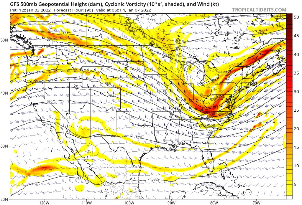
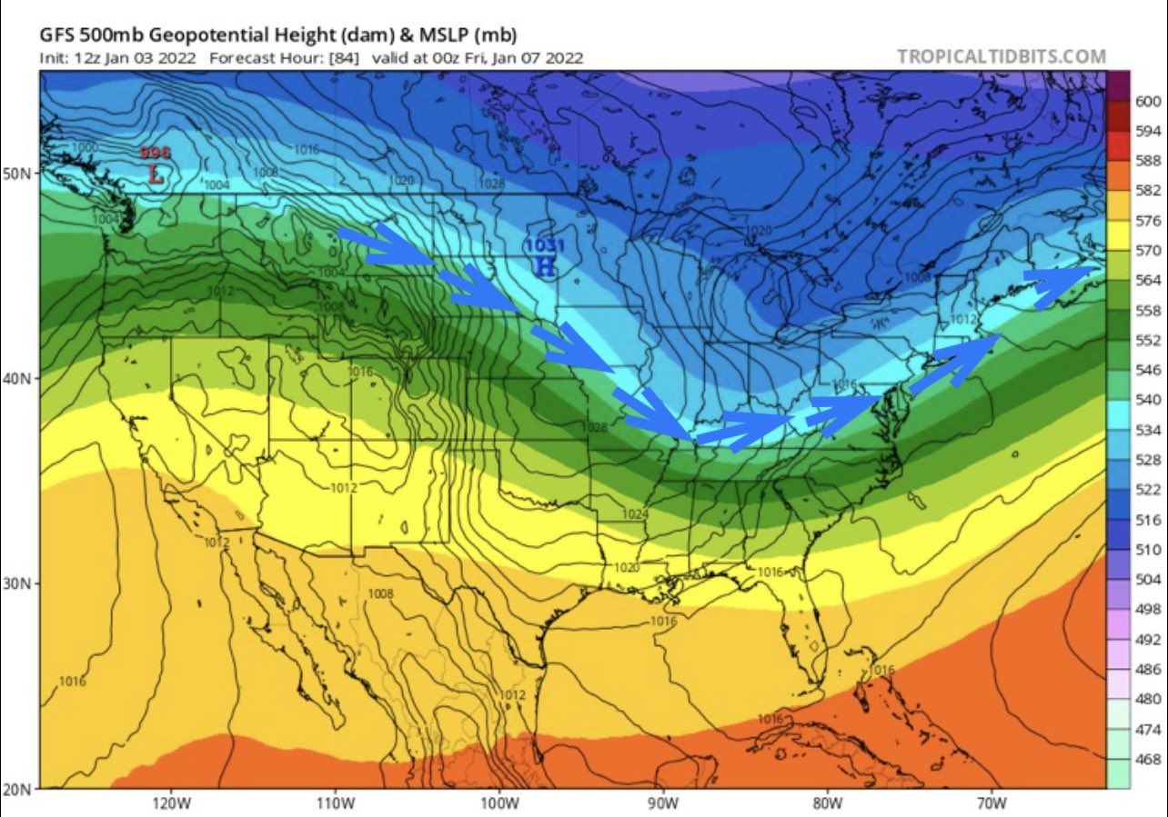
Lots to figure out with the 1/7 threat. But your bigger snow storms tend to have negatively tilted troughs, moisture fetch from the Atlantic and ample supply of cold air. This has the makings of all three. At the very least confidence is growing for at least a moderate event that affects more of the area. Note the classic comma head which is indicative of your bigger storms. We shall see...
Limiting factor here is the progression of the storm. IT's kind of fast.

heehaw453- Advanced Forecaster
- Posts : 3907
Reputation : 86
Join date : 2014-01-20
Location : Bedminster Township, PA Elevation 600' ASL
Page 4 of 19 • 1, 2, 3, 4, 5 ... 11 ... 19 ![]()
|
|
|